| |
| Proportion | 2:3 |
|---|---|
| Adopted | 17 February 2010 |
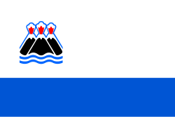
| Design | A horizontal bicolour of white and blue with the emblem of the krai. |
| Designed by | Ivan Tsarkov |
The flag of Kamchatka Krai , in the Russian Federation, is a horizontal bicolour of white and blue charged with an emblem. The emblem is a modification of the coat of arms of Kamchatka Krai: three snow-capped volcano peaks on the backdrop of a red sun framed by an ornament.
The flag was adopted on 17 February 2010 by the Legislative Assembly of Kamchatka Krai, and came into use 1 July 2010.
Before 2007, the territory that is now Kamchatka Krai was two federal subjects called Kamchatka Oblast and Koryak Autonomous Okrug and thus their respective flags were used instead.