Fullerton Cove, New South Wales

Last updated

Fullerton Cove
New South Wales

Stanley Park at Fullerton Cove 03.jpg

Historical Stanley Park property on Fullerton Cove Road
Australia New South Wales location map blank.svg
Red pog.svg
Fullerton Cove
Coordinates 32°50′36″S151°49′35″E / 32.84333°S 151.82639°E / -32.84333; 151.82639 Coordinates: 32°50′36″S151°49′35″E / 32.84333°S 151.82639°E / -32.84333; 151.82639
Population 300 (2011 census) [1]
 • Density 9.6/km2 (25/sq mi)
Postcode(s) 2318
Elevation 3.7 m (12 ft) [Note 1]
Area 31.3 km2 (12.1 sq mi) [Note 2]
Time zone AEST (UTC+10)
 • Summer (DST) AEDT (UTC+11)
Location
LGA(s) Port Stephens Council [2]
Region Hunter
County Gloucester [3]
Parish Stowell [3]
State electorate(s) Newcastle
Federal Division(s) Paterson
Mean max temp [4] Mean min temp [4] Annual rainfall [4]
27.9 °C
82 °F
6.4 °C
44 °F
1,125.6 mm
44.3 in
Suburbs around Fullerton Cove:
Williamtown, Tomago Williamtown Williamtown
Tomago Fullerton Cove Tasman Sea
Kooragang Fern Bay Tasman Sea

Fullerton Cove is a rural suburb of the Port Stephens local government area in the Hunter Region of New South Wales, Australia, located just north of Fern Bay and adjacent to Fullerton Cove, from which the suburb gets its name. [2] [5] [6] At the 2011 census the population of Fullerton Cove was 300. [1]

Port Stephens Council Local government area in New South Wales, Australia

Port Stephens Council is a local government area in the Hunter Region of New South Wales, Australia. The area is just north of Newcastle and is adjacent to the Pacific Highway which runs through Raymond Terrace, the largest town and Council seat. The area is named after Port Stephens, which is the major geographical feature of the area. It extends generally from the Hunter River in the south, to near Clarence Town in the north, and from the Tasman Sea in the east, to just south of Paterson in the west. The mayor of Port Stephens Council is Ryan Palmer. Port Stephens is about two and a half hours north of Sydney.

Local government in Australia is the third tier of government in Australia administered by the states and territories, which in turn are beneath the federal tier. Local government is not mentioned in the Constitution of Australia and two referenda in the 1970s and 1980s to alter the Constitution relating to local government were unsuccessful. Every state government recognises local government in their respective constitutions. Unlike Canada or the United States, there is only one level of local government in each state, with no distinction such as cities and counties.

Hunter Region Region in New South Wales, Australia

The Hunter Region, also commonly known as the Hunter Valley, is a region of New South Wales, Australia, extending from approximately 120 km (75 mi) to 310 km (193 mi) north of Sydney. It contains the Hunter River and its tributaries with highland areas to the north and south. Situated at the northern end of the Sydney Basin bioregion, the Hunter Valley is one of the largest river valleys on the NSW coast, and is most commonly known for its wineries and coal industry.

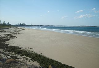
Like Fern Bay Fullerton Cove lies to the west of the Tasman Sea. Although the entire coastline is part of Stockton Beach there is no public access to the beach from Fullerton Cove. The only access in the suburb is via a private track, which is off-limits to the public, in a large sand mining development at the end of Coxs Lane. Sand tracks in this area provide best access to the wreck of the MV Sygna, a 53,000 tonne Norwegian bulk carrier that ran aground during a major storm on 26 May 1974 and which has since become an icon and landmark for the local area as well as being a popular destination for off-road enthusiasts driving along Stockton Beach.

Tasman Sea A marginal sea of the South Pacific between Australia and New Zealand

The Tasman Sea is a marginal sea of the South Pacific Ocean, situated between Australia and New Zealand. It measures about 2,000 kilometres (1,200 mi) across and about 2,800 kilometres (1,700 mi) from north to south. The sea was named after the Dutch explorer Abel Janszoon Tasman, who was the first recorded European to encounter New Zealand and Tasmania. The British explorer Captain James Cook later extensively navigated the Tasman Sea in the 1770s as part of his first voyage of exploration.

Stockton Beach New South Wales, Australia

Stockton Beach is located north of the Hunter River in New South Wales, Australia. It is 32 km (20 mi) long and stretches from Stockton, to Anna Bay. Over many years Stockton Beach has been the site of numerous shipwrecks and aircraft crash sites. In World War II it was fortified against a possible attack by Imperial Japanese forces. During that time it served as a bombing and gunnery range as well as a dumping area for unused bombs by aircraft returning from training sorties. The length of the beach, its generally hard surface and numerous items of interest along the beach make it popular with four-wheel drive (4WD) enthusiasts. Four-wheel drive vehicles are permitted to drive on Stockton Beach provided the vehicles are in possession of valid permits. The beach is also popular with fishermen and several different varieties of fish may be caught.

Sand mining is the extraction of sand, mainly through an open pit but sometimes mined from beaches and inland dunes or dredged from ocean and river beds. Sand is often used in manufacturing, for example as an abrasive or in concrete. It is also used on icy and snowy roads, usually mixed with salt, to lower the melting point temperature on the road surface. Sand can replace eroded coastline. Some uses require higher purity than others; for example sand used in concrete must be free of seashell fragments.

Most of the population in the suburb is limited to an area along Fullerton Cove Road in a corridor of approximately 2.4 square kilometres (0.9 sq mi), or 7.7% of the total suburb's area. [5] Although the suburb is surrounded by several others, the only public road into the suburb is Nelson Bay Road, from Fern Bay in the south and Williamtown in the north. [5]

Williamtown, New South Wales Suburb of Port Stephens Council, New South Wales, Australia

Williamtown is a rural suburb of the Port Stephens local government area in the Hunter Region of New South Wales, Australia. It is located on the main road between Newcastle and Nelson Bay.

The MV Sygna as she lay off Stockton Beach on 6 June 2009 Sygna-june-09.jpg
The MV Sygna as she lay off Stockton Beach on 6 June 2009

Notes

  1. Fullerton Cove is primarily flat however it does have some elevated areas, mainly in the form of vegetated sandhills up to 9.1 metres (30 ft) above mean sea level. The figure presented represents the average elevation throughout the majority of the suburb as shown on 1:100000 map NEWCASTLE 9232.
  2. Area calculation is based on 1:100000 map 9232 NEWCASTLE.

Related Research Articles

Stockton, New South Wales Suburb of Newcastle, New South Wales, Australia

Stockton is a suburb of Newcastle, New South Wales, Australia, located 600 m (0.4 mi) from Newcastle's central business district. It is the only residential suburb of Newcastle that lies north of the Hunter River.

Lemon Tree Passage, New South Wales Suburb of Port Stephens Council, New South Wales, Australia

Lemon Tree Passage is a suburb of the Port Stephens local government area in the Hunter Region of New South Wales, Australia, located at the end of the Tilligerry Peninsula and surrounded by the waters of Port Stephens. At the 2011 census it had a population of 2,547. It is a haven for koalas due to it being densely wooded. The town has a small marina and the local industry is oyster farming.

Medowie, New South Wales Town in New South Wales, Australia

Medowie is a suburb of the Port Stephens local government area in the Hunter Region of New South Wales, Australia. It is located approximately 34 km (21 mi) by road north of Newcastle, not far from RAAF Base Williamtown and is home to a large number of the personnel stationed there.

Salamander Bay, New South Wales Suburb of Port Stephens Council, New South Wales, Australia

Salamander Bay is a suburb of the Port Stephens local government area in the Hunter Region of New South Wales, Australia. Named after the adjacent shallow bay, itself named after Salamander, a convict ship from the Third Fleet, which was the first European vessel to enter Port Stephens (1791), it is a mainly residential suburb with a large shopping centre. At the 2011 census Salamander Bay had a population of 4,844. It is home to Tomaree High School, a TAFE facility and St Phillips Christian College.

Nelson Bay, New South Wales Suburb of Port Stephens Council, New South Wales, Australia

Nelson Bay is a suburb of the Port Stephens local government area in the Hunter Region of New South Wales, Australia. It is located on a bay of the same name on the southern shore of Port Stephens about 60 kilometres (37 mi) by road north-east of Newcastle, its nearest rail link. At the 2016 census, Nelson Bay had a population of 5,820.

Salt Ash, New South Wales Suburb of Port Stephens Council, New South Wales, Australia

Salt Ash is a rural suburb of the Port Stephens local government areas in the Hunter Region of New South Wales, Australia. It is located on the main road between Newcastle and Nelson Bay but is largely undeveloped, partly because it is the location of the Salt Ash Air Weapons Range which is used by pilots from RAAF Base Williamtown for training purposes.

Bobs Farm, New South Wales Suburb of Port Stephens Council, New South Wales, Australia

Bobs Farm is a sparsely populated rural suburb of the Port Stephens local government area in the Hunter Region of New South Wales, Australia. It is on the main road between Newcastle and Nelson Bay and is home to a number of small, boutique style vineyards and wineries and a thriving aquaculture industry.

Tomago, New South Wales Suburb of Port Stephens Council, New South Wales, Australia

Tomago is a combined industrial/semi-rural suburb of the Port Stephens local government area in the Hunter Region of New South Wales, Australia. It is located just north of the Hunter River and west of the body of water known as Fullerton Cove. Tomago means "sweet water" in the local Aboriginal language.

One Mile, New South Wales Suburb of Port Stephens Council, New South Wales, Australia

One Mile is a suburb of the Port Stephens local government area in the Hunter Region of New South Wales, Australia. The suburb is semi-rural with a small urban settlement, two eco-resorts and back-packer accommodation to the west of Gan Gan Road. On the beach side there is a residential land-lease community and three tourist parks. The parks, two of which have licensed restaurants, are positioned to provide quick access to the suburb's two beaches. Since late 2017 Port Stephens Koala Hospital has been operating in the grounds of Treescape resort.

Fern Bay, New South Wales Suburb of Port Stephens Council, New South Wales, Australia

Fern Bay is the southern-most suburb of the Port Stephens local government area in the Hunter Region of New South Wales, Australia. It is located just north of Stockton, which is the only suburb of Newcastle that lies north of the Hunter River and to the east of the north arm of the Hunter River at the entrance to Fullerton Cove, a large body of water. To the east is the Tasman Sea. Despite the suburb only being 6 kilometres (3.7 mi) in a direct line from Newcastle, the need to cross the Hunter River results in Fern Bay being 16 km (9.9 mi) by road from the centre of the city.

Tanilba Bay, New South Wales Town in New South Wales, Australia

Tanilba Bay is a suburb of the Port Stephens local government area in the Hunter Region of New South Wales, Australia. It is located on the Tilligerry Peninsula adjacent to the bay from which it got its name. "Tanilba" is said to mean "place of white flowers" in a local Indigenous language, presumably a reference to the flannel flowers which formerly thrived in the area. At the 2016 census Tanilba Bay had a population of 3,156.

Mallabula, New South Wales Suburb of Port Stephens Council, New South Wales, Australia

Mallabula is a primarily residential suburb of the Port Stephens local government area in the Hunter Region of New South Wales, Australia. It is located on the Tilligerry Peninsula between Lemon Tree Passage and Tanilba Bay. The origin of the name may mean "three swamps" in the local Aboriginal language.

Hinton, New South Wales Suburb of Port Stephens Council, New South Wales, Australia

Hinton is a suburb of the Port Stephens local government area in the Hunter Region of New South Wales, Australia. Primarily rural, the largest population centre is the township of Hinton, which is situated on the Paterson River, near to the confluence of the Hunter and Paterson rivers.

Bar Beach, New South Wales Suburb of Newcastle, New South Wales, Australia

Bar Beach is an inner city suburb of Newcastle, New South Wales, Australia, located 1.6 km (1.0 mi) southwest of Newcastle's central business district. The suburb is named for the beach that extends along its eastern border.

Osterley, New South Wales Suburb of Port Stephens Council, New South Wales, Australia

Osterley is a small rural suburb of the Port Stephens local government area in the Hunter Region of New South Wales, Australia. Most of the small population lives in the elevated part of the suburb along Hinton Road, east of Barties Creek which is a tributary of the Hunter River. The area to the west of Barties creek is low-lying and subject to periodic flooding.

Nelsons Plains, New South Wales Suburb of Port Stephens Council, New South Wales, Australia

Nelsons Plains is a primarily rural suburb of the Port Stephens local government area in the Hunter Region of New South Wales, Australia. It is situated on Seaham Road between the Hunter and Williams rivers. At the 2011 census the suburb had a population of 324.

Wallalong, New South Wales Suburb of Port Stephens Council, New South Wales, Australia

Wallalong is a rural suburb of the Port Stephens local government area in the Hunter Region of New South Wales, Australia. The suburb is bisected by High Street, along which a small residential zone of 938 people exists. To the east and west of this area the suburb is almost exclusively rural.

Campvale, New South Wales Suburb of Port Stephens Council, New South Wales, Australia

Campvale is a sparsely populated rural suburb of the Port Stephens local government area in the Hunter Region of New South Wales, Australia.

Ferodale, New South Wales Suburb of Port Stephens Council, New South Wales, Australia

Ferodale is a sparsely populated rural suburb of the Port Stephens local government area in the Hunter Region of New South Wales, Australia. A large portion of the suburb is occupied by Grahamstown Dam, the lower Hunter Region's main water storage reservoir.

References

  1. 1 2 Australian Bureau of Statistics (31 October 2012). "Fullerton Cove (State Suburb)". 2011 Census QuickStats. Retrieved 13 October 2012. Blue pencil.svg
  2. 1 2 "Suburb Search - Local Council Boundaries - Hunter (HT) - Port Stephens". New South Wales Division of Local Government. Archived from the original on 21 June 2014. Retrieved 8 June 2008.
  3. 1 2 "Fullerton Cove (suburb)". Geographical Names Register (GNR) of NSW. Geographical Names Board of New South Wales . Retrieved 27 May 2008.
  4. 1 2 3 "Williamtown RAAF". Climate statistics for Australian locations. Bureau of Meteorology . Retrieved 2 June 2008.
  5. 1 2 3 "Fullerton Cove". Land and Property Management Authority - Spatial Information eXchange. New South Wales Land and Property Information . Retrieved 27 May 2008.
  6. "Fullerton Cove (cove)". Geographical Names Register (GNR) of NSW. Geographical Names Board of New South Wales . Retrieved 27 May 2008.

Commons-logo.svg Media related to Fullerton Cove, New South Wales at Wikimedia Commons