Tea Gardens is a locality in the Mid-Coast Council local government area, located near the southern extremity of the Mid North Coast and the northern extremity of the Hunter Region in New South Wales, Australia.

Port Stephens, an open youthful tide-dominated drowned-valley estuary, is a large natural harbour of approximately 134 square kilometres (52 sq mi) located in the Hunter Region of New South Wales, Australia.

Salamander Bay is a suburb of the Port Stephens local government area in the Hunter Region of New South Wales, Australia. The Worimi people are the traditional owners of the Port Stephens area. Named after the adjacent shallow bay, itself named after Salamander, a convict ship from the Third Fleet, which was the first European vessel to enter Port Stephens (1791), it is a mainly residential suburb with a large shopping centre. At the 2021 census, Salamander Bay had a population of 4,991. It is home to Tomaree High School, a TAFE facility and St Phillips Christian College.

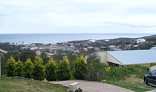
Fingal Bay is the easternmost suburb of the Port Stephens local government area in the Hunter Region of New South Wales, Australia. The only population centre is the township of the same name, which itself is named after the adjacent, small, semi-circular bay. At the 2021 census, the population of the town was 1,635.
Hawks Nest is a small town of the Mid-Coast Council local government area in the Hunter and Mid North Coast regions of New South Wales, Australia, located north of Port Stephens between the Tasman Sea and the Myall River. It was named after a large hawk's nest in a tree on the Myall River that was used as a navigational aid. The traditional custodians of this land are the Worimi people.

Raymond Terrace is a town in the Hunter Region of New South Wales, Australia, about 26 km (16 mi) by road north of Newcastle on the Pacific Highway. Established in 1837 it is situated at the confluence of the Hunter and Williams rivers. The town was named after Lieutenant Raymond, who had explored the Hunter River in 1797 and described the terraced appearance of trees in the area. Governor Lachlan Macquarie camped in the area in 1818, using "Raymond Terrace" as the name for the place where his party had camped.
Nelson Bay is a significant township of the Port Stephens local government area in the Hunter Region of New South Wales, Australia. It is located on a bay of the same name on the southern shore of Port Stephens about 60 kilometres (37 mi) by road north-east of Newcastle, its nearest rail link. At the 2021 census, Nelson Bay had a population of 6,141.

Port Stephens Council is a local government area in the Hunter Region of New South Wales, Australia. The area is just north of Newcastle and is adjacent to the Pacific Highway which runs through Raymond Terrace, the largest town and Council seat. The area is named after Port Stephens, which is the major geographical feature of the area. It extends generally from the Hunter River in the south, to near Clarence Town in the north, and from the Tasman Sea in the east, to just south of Paterson in the west. The mayor of Port Stephens Council is Ryan Palmer. Palmer was caught in a major scandal in 2022 following the purchase of an $86,000 Ford Ranger for mayoral and personal use. Port Stephens is about two and a half hours north of Sydney.

Shoal Bay is the most eastern suburb of the Port Stephens local government area in the Hunter Region of New South Wales, Australia. It is located on the southern shore of Port Stephens, adjacent to the bay of the same name at the entrance to the port. It includes part of Tomaree National Park within its boundaries and, like other suburbs around Port Stephens, is a popular tourist destination, especially in summer months. At the 2021 census the town of Shoal Bay had a population of 1,815 but the population increases significantly during tourist season.

Salt Ash is a rural suburb of the Port Stephens local government areas in the Hunter Region of New South Wales, Australia. It is located on the main road between Newcastle and Nelson Bay but is largely undeveloped, partly because it is the location of the Salt Ash Air Weapons Range which is used by pilots from RAAF Base Williamtown for training purposes.

Bobs Farm is a sparsely populated rural suburb of the Port Stephens local government area in the Hunter Region of New South Wales, Australia. It is on the main road between Newcastle and Nelson Bay and is home to a number of small, boutique style vineyards and wineries and a thriving aquaculture industry. Bobs Farm Public School on Marsh Road is a co-educational government primary school which was established in 1918.

Williamtown is a rural suburb of the Port Stephens local government area in the Hunter Region of New South Wales, Australia. It is located on the main road between Newcastle and Nelson Bay.
Corlette is a suburb of the Port Stephens local government area in the Hunter Region of New South Wales, Australia. It is located just west of Nelson Bay on the shores of Port Stephens. It was named after Captain James Corlette who skippered the 63 tonnes cutter Lambton which was the first privately owned local vessel. Corlette first used it to ship timber and wool out of Port Stephens in 1816. While property values throughout the suburb average around A$1,100,000 in the most affluent areas on the shores of Salamander Bay individual sale prices of $3.7 million have been realised. It has many local tourism attractions including Bagnalls Beach Reserve, Port Stephens Shell Museum, Blue Water Sailing and Nude Kayaks.

One Mile is a suburb of the Port Stephens local government area in the Hunter Region of New South Wales, Australia. The Worimi people are the traditional owners of the Port Stephens area. The suburb is semi-rural with a small urban settlement, several eco-resorts and back-packer accommodations to the west of Gan Gan Road. On the beach side there is a residential land-lease community and three tourist parks. The parks, two of which have licensed restaurants, are positioned to provide quick access to the suburb's two beaches. Since late 2017 Port Stephens Koala Hospital has been operating in the grounds of Treescape resort.
Boat Harbour is a suburb of the Port Stephens local government area in the Hunter Region of New South Wales, Australia. The main population centre of the suburb is the village also known as Boat Harbour. Both lie adjacent to the bay after which they were named. The traditional owners of the land are Worimi people.

Anna Bay is the name of a suburb, a town and a bay in the Port Stephens local government area in the Hunter Region of New South Wales, Australia. The suburb and town are immediately adjacent to the north-eastern end of Stockton Beach and provide one of the major entry points to the beach at Birubi Point. Both were named after the bay of the same name which is located in the adjacent suburb of One Mile. According to legend to it was originally called Hannah Bay after an alleged shipwreck in 1851 but the vessel has never been identified. The name was changed by post service on 15 May 1896 as many locals were already referring to it as Anna Bay.

Tanilba Bay is a suburb of the Port Stephens local government area in the Hunter Region of New South Wales, Australia. It is located on the Tilligerry Peninsula adjacent to the bay from which it got its name. "Tanilba" is said to mean "place of white flowers" in a local Indigenous language, presumably a reference to the flannel flowers which formerly thrived in the area. At the 2021 census Tanilba Bay had a population of 3,237. Tanilba Bay Public School is a co-ed government primary school located at 1A King Albert Avenue.

Taylors Beach is a suburb of the Port Stephens local government area in the Hunter Region of New South Wales, Australia. It is largely undeveloped except for some commercial and light industrial developments in the southern part of the suburb. The largest population centre is at Taylors Beach itself, in the western part of the suburb, adjacent to Tilligerry Creek and Port Stephens. At the 2021 census Taylors Beach had a population of 120.

Nelsons Plains is a primarily rural suburb of the Port Stephens local government area in the Hunter Region of New South Wales, Australia. It is situated on Seaham Road between the Hunter and Williams rivers. At the 2016 census the suburb had a population of 362.

East Seaham is a primarily rural suburb of the Port Stephens local government area in the Hunter Region of New South Wales, Australia. It is situated on the east bank of the Williams River, opposite Glen Oak and Seaham. At the 2011 census, the population of East Seaham and the adjacent suburb of Balickera was 359, with the two suburbs having an average population density of 5.5/km2 (14/sq mi).

