Functional area (France)

Last updated
Functional areas (AAV) of Metropolitan France in 2020, broken down by communes (commune borders as of January 1, 2020):
.mw-parser-output .legend{page-break-inside:avoid;break-inside:avoid-column}.mw-parser-output .legend-color{display:inline-block;min-width:1.25em;height:1.25em;line-height:1.25;margin:1px 0;text-align:center;border:1px solid black;background-color:transparent;color:black}.mw-parser-output .legend-text{}
Communes in the main population and employment centre of a functional area
Communes in a secondary population and employment centre of a functional area
Communes in the commuting zone of a functional area (functional areas with more than 700,000 inhabitants)
Communes in the commuting zone of a functional area (functional areas between 200,000 and 700,000 inhabitants)
Communes in the commuting zone of a functional area (functional areas between 50,000 and 200,000 inhabitants)
Communes in the commuting zone of a functional area (functional areas with less than 50,000 inhabitants)
Communes outside of functional areas FR-AAV-2020-simplified.png
Functional areas (AAV) of Metropolitan France in 2020, broken down by communes (commune borders as of January 1, 2020):
  Communes in the main population and employment centre of a functional area
  Communes in a secondary population and employment centre of a functional area
  Communes in the commuting zone of a functional area (functional areas with more than 700,000 inhabitants)
  Communes in the commuting zone of a functional area (functional areas between 200,000 and 700,000 inhabitants)
  Communes in the commuting zone of a functional area (functional areas between 50,000 and 200,000 inhabitants)
  Communes in the commuting zone of a functional area (functional areas with less than 50,000 inhabitants)
  Communes outside of functional areas

An aire d'attraction d'une ville [note 1] (or AAV, literally meaning "catchment area of a city") is a statistical area used by France's national statistics office INSEE since 2020, officially translated as functional area in English by INSEE, [2] which consists of a densely populated urban agglomeration and the surrounding exurbs, towns and intervening rural areas that are socioeconomically tied to the central urban agglomeration, as measured by commuting patterns. [1] INSEE's functional area (AAV) is therefore akin to what is most often called metropolitan area in English.

Contents

Definition

INSEE's AAV follows the same definition as the Functional Urban Area (FUA) used by Eurostat and the OECD, and the AAVs are thus strictly comparable to the FUAs. [2] Before 2020, INSEE used another metropolitan statistical area, the aire urbaine (AU), which was defined differently than the AAV, but the AU has now been discontinued and replaced with the AAV in order to facilitate international comparisons with Eurostat's FUAs. [2]

The functional area is a grouping of communes comprising a 'population and employment centre' (pôle de population et d'emploi in French), [2] [3] which Eurostat calls "city" or "greater city" (depending on the FUA), [4] defined according to population and employment criteria, and an outlying 'commuting zone' (couronne in French), [2] [3] which Eurostats calls "commuting zone" in English, [4] like INSEE, but zone de navettage in French [5] (unlike INSEE which calls it couronne), in which at least 15% of the working population work in the population and employment centre. [2]

List of functional areas (AAV)

The following is a list of the thirty five largest functional areas (AAV) in France, based on their population at the 2020 census. Population at the 2008 and 1990 censuses is indicated for comparison.

Rank
(2020)
Rank
(2008)
Rank
(1990)
Functional area
(AAV)
Population
(2020) [6]
Population
(2008) [7]
Population
(1990) [8]
Yearly change
(2008-2020)
Yearly change
(1990-2008)
Land area
(km²) [9]
Number of
communes [10]
111  Paris 13,125,142 12,479,272 11,392,740 +0.42%+0.51%18,9411,929
222  Lyon 2,293,180 2,050,795 1,790,325 +0.94%+0.77%4,606398
333  Marseille - Aix-en-Provence 1,879,601 1,800,122 1,594,849 +0.36%+0.68%3,972115
444  Lille (French part)1,515,061 1,448,868 1,390,191 +0.37%+0.23%1,666201
556  Toulouse 1,470,899 1,252,358 935,009 +1.35%+1.65%6,520527
665  Bordeaux 1,376,375 1,171,456 986,179 +1.35%+0.97%6,316275
777  Nantes 1,022,775 873,569 722,234 +1.32%+1.07%3,471116
888  Strasbourg (French part)860,744 805,611 704,238 +0.55%+0.76%2,227268
91013  Montpellier 813,272 680,929 501,936 +1.49%+1.73%2,414161
101212  Rennes 763,749 659,941 521,255 +1.22%+1.33%3,804183
11910  Grenoble 720,081 689,042 614,455 +0.37%+0.65%2,876204
12119  Rouen 708,289 680,844 646,549 +0.33%+0.29%2,792317
131311  Nice [note 2] 618,489 606,605 558,520 +0.16%+0.46%2,073100
141416  Toulon 576,648 542,008 481,466 +0.52%+0.67%1,00435
151617  Tours 522,317 492,968 437,547 +0.48%+0.67%3,632162
161514  Nancy 508,947 510,668 496,486 -0.03%+0.16%3,121353
171818  Clermont-Ferrand 507,954 471,581 432,862 +0.62%+0.48%2,845209
181715  Saint-Étienne 500,851 483,053 491,789 +0.30%-0.10%1,636105
191919  Caen 475,144 446,464 399,635 +0.52%+0.62%2,597296
202020  Orléans 454,208 424,419 374,252 +0.57%+0.71%3,422136
213041  Geneva - Annemasse (French part) [note 3] 439,300 347,977 258,475 +1.96%+1.68%1,737158
222223  Angers 437,560 403,371 355,626 +0.68%+0.71%2,41981
232634  Perpignan 418,104 375,133 301,619 +0.91%+1.23%1,775118
242322  Dijon 413,996 394,820 365,025 +0.40%+0.44%3,896333
252121  Mulhouse 410,008 404,298 370,251 +0.12%+0.49%1,227132
262430  Cannes - Antibes 393,232 391,654 332,735 +0.03%+0.92%43224
272726  Metz 373,821 363,595 338,432 +0.23%+0.40%1,877245
282827  Brest 373,808 357,835 335,795 +0.36%+0.36%1,26568
292933  Le Mans 369,976 356,861 326,702 +0.30%+0.50%2,340144
303232  Reims 355,617 343,808 329,208 +0.28%+0.24%3,251294
313131  Amiens 354,217 346,294 329,927 +0.19%+0.27%3,076369
322525  Fort-de-France 347,170 380,831 340,815 -0.77%+0.62%97428
333940  Nîmes 347,033 315,480 259,675 +0.80%+1.10%1,46892
343428  Valenciennes (French part)337,293 334,996 335,758 +0.06%-0.01%725102
353838  Avignon 337,039 317,744 272,025 +0.49%+0.88%96448

See also

Notes

  1. Plural: aires d'attraction des villes. [1]
  2. Does not include Cannes-Antibes, which is a considered by INSEE a separate AAV, contrary to the old aire urbaine of Nice which included Cannes and Antibes.
  3. French part of the Geneva Functional Urban Area (2,292 km2 (885 sq mi)) [11] which extends over Swiss and French territory, and had a population of 1,044,766 in Jan. 2020 (Swiss estimates and French census), 605,466 of them on Swiss territory and 439,300 on French territory. [12]

Related Research Articles

<span class="mw-page-title-main">Geneva</span> City in southwestern Switzerland

Geneva is the second-most populous city in Switzerland and the most populous city of Romandy, the French-speaking part of Switzerland. Situated in the south west of the country, where the Rhône exits Lake Geneva, it is the capital of the Republic and Canton of Geneva.

<span class="mw-page-title-main">Metropolitan area</span> Administrative unit of a dense urban core and its satellite cities

A metropolitan area or metro is a region that consists of a densely populated urban agglomeration and its surrounding territories sharing industries, commercial areas, transport network, infrastructures and housing. A metro area usually comprises multiple principal cities, jurisdictions and municipalities: neighborhoods, townships, boroughs, cities, towns, exurbs, suburbs, counties, districts, as well as even states and nations like the eurodistricts. As social, economic and political institutions have changed, metropolitan areas have become key economic and political regions.

<span class="mw-page-title-main">Urban area (France)</span> Statistical area in France

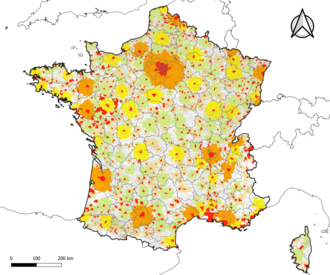
An aire urbaine is an INSEE statistical concept describing a core of urban development and the extent of its commuter activity. It was replaced by the concept "functional area", which uses the same definition as Eurostat's functional urban areas, in 2020.

<span class="mw-page-title-main">Demographics of Paris</span>

The city of Paris had a population of 2,165,423 people within its administrative city limits as of January 1, 2019. It is surrounded by the Paris unité urbaine, or urban area, the most populous urban area in the European Union. In 2018 the unité urbaine had a population of 10,816,803 in 2,854 km2 (1,102 sq mi). The Paris Region, or Île-de-France covers 12,012 km2 (4,638 sq mi), and has its own regional council and president. It has a population of 12,213,447 as of January 2018, or 18.3 percent of the population of France. The metropolitan or functional area of Paris covers 18,941 km2 (7,313 sq mi) and has 13,064,617 inhabitants (2018).

Aire-la-Ville is a municipality in the canton of Geneva in Switzerland.

<span class="mw-page-title-main">Urban unit</span> A French statistical area

In France, an urban unit is a statistical area defined by INSEE, the French national statistics office, for the measurement of contiguously built-up areas. According to the INSEE definition, an "unité urbaine" is a commune alone or a grouping of communes which: a) form a single unbroken spread of urban development, with no distance between habitations greater than 200 m and b) have all together a population greater than 2,000 inhabitants. Communes not belonging to an unité urbaine are considered rural.

<span class="mw-page-title-main">Paris metropolitan area</span> Statistical area

The Paris metropolitan area is a statistical area that describes the reach of commuter movement to and from Paris, France and its surrounding suburbs.

<span class="mw-page-title-main">Saint-Galmier</span> Commune in Auvergne-Rhône-Alpes, France

Saint-Galmier is a city in eastern France. It is a commune in Loire department, and belongs to the arrondissement of Montbrison. Saint-Galmier covers an area of 19.5 square kilometers. As of January 1, 2018, it had a population of 5,737, ranking 1,903th among French communes.

The larger urban zone (LUZ), or functional urban area (FUA), is a measure of the population and expanse of metropolitan and surrounding areas which may or may not be exclusively urban. It consists of a city and its commuting zone outside it.

<span class="mw-page-title-main">Nice metropolitan area</span> Metropolitan area in France

Nice metropolitan area as defined by INSEE in 2021 is the functional urban area or commuting zone of the city of Nice, southeastern France. It covers 100 communes, has 1,103,527 inhabitants (2021) and an area of 2,073 km2. It partly overlaps with the urban unit of Nice, which covers some cities, e.g. Antibes, Grasse and Cannes, that are part of the functional area Cannes-Antibes.

<span class="mw-page-title-main">Saint-Martin-de-Bavel</span> Commune in Auvergne-Rhône-Alpes, France

Saint-Martin-de-Bavel is a commune in the Ain department in eastern France.

<span class="mw-page-title-main">Chambon, Cher</span> Commune in Centre-Val de Loire, France

Chambon is a commune in the Cher department in the Centre-Val de Loire region of France.

<span class="mw-page-title-main">Marcilly-sur-Tille</span> Commune in Bourgogne-Franche-Comté, France

Marcilly-sur-Tille is a commune in the Côte-d'Or department in eastern France.

Talasani is a rural commune and village on the eastern seaboard of Corsica. It in the Haute-Corse department of France. The area has very low population density and is mainly forests and farmland. Being a coastal municipality, Talasani recognizes strict urban planning provisions in order to preserve the ecological balance of the coast.

<span class="mw-page-title-main">Chanteau</span> Commune in Centre-Val de Loire, France

Chanteau is a commune in the Loiret department in north-central France. It is part of the functional urban area of Orléans.

Champvoisy is a commune in the Marne department in north-eastern France. It is a rural municipality, with a very low population density. The municipality is part of the functional area of Reims, which is composed of 294 municipalities.

Pomps is a commune in the Pyrénées-Atlantiques département in south-western France. An individual from Pomps is known as Pompsois.

<span class="mw-page-title-main">Grenoble metropolitan area</span> Urban area of Grenoble

Grenoble metropolitan area as defined by INSEE in 2020 is the functional urban area of the city of Grenoble, southeastern France. It covers 204 communes, all in the Isère department. It has 714,799 inhabitants (2018) in an area of 2,876 km2 (1,110 sq mi), which is 39% of the Isère department. Grenoble and 15 other communes form the pôle urbain or urban cluster, the other 188 communes form the couronne or commuter belt. The most populous communes in the functional area are Grenoble, Échirolles, Fontaine, Meylan, Le Pont-de-Claix, Saint-Égrève, Saint-Martin-d'Hères, Sassenage, Seyssinet-Pariset and Voiron, all except Voiron part of the pôle urbain. It is the 11th-most populous functional urban area in France.

<span class="mw-page-title-main">Cherbourg-en-Cotentin</span> Subprefecture and commune in Normandy, France

Cherbourg-en-Cotentin is a city in the department of Manche, Normandy, northwestern France, established on 1 January 2016. The commune takes its name from Cherbourg, the main town of the commune, and the Cotentin Peninsula. Cherbourg is an important commercial, ferry and military port on the English Channel. Cherbourg-en-Cotentin is a Maritime prefecture and sub-prefecture of Manche. Due to its union, it is the most populous commune in its department with 79,144 inhabitants as of 2018, making it the first city of the department before the Saint-Lô prefecture and the second in the region after Caen. Its urban unit is composed of three communes, and has 81,963 inhabitants (2018). Its larger functional area has 152,630 inhabitants (2018).

References

  1. 1 2 "Le nouveau zonage en aires d'attraction des villes". INSEE . Retrieved 2022-04-26.
  2. 1 2 3 4 5 6 "Functional areas - Definition". INSEE . Retrieved 2022-04-26.
  3. 1 2 "Aire d'attraction des villes - Définition". INSEE . Retrieved 2022-04-26.
  4. 1 2 "What is a city? - Spatial units". Eurostat . Retrieved 2022-04-26.
  5. "Qu'est-ce qu'une ville? — Unités spatiales". Eurostat . Retrieved 2022-04-26.
  6. INSEE. "France par aire d'attraction des villes - Population municipale 2020 >> Tableau" . Retrieved 2023-03-09.
  7. INSEE. "France par aire d'attraction des villes - Population municipale (historique depuis 1876) 2008 >> Tableau" . Retrieved 2022-04-27.
  8. INSEE. "France par aire d'attraction des villes - Population municipale 1990 >> Tableau" . Retrieved 2022-04-27.
  9. INSEE. "Comparateur de territoire" . Retrieved 2022-04-27.
  10. INSEE. "Base des aires d'attraction des villes 2020 au 1ᵉʳ janvier 2022" . Retrieved 2022-04-29.
  11. As of 2020, the Eurostat-defined Functional Urban Area of Geneva was made up of 93 Swiss communes and 158 French communes: Federal Statistical Office spreadsheet listing the Swiss and French communes of the Geneva Functional Urban Area.
    Land area of the 93 Swiss communes: 555.1 km² (source: ).
    Land area of the 158 French communes: 1737.1 km² (source:
    ).
  12. As of 2020, the Eurostat-defined Functional Urban Area of Geneva was made up of 93 Swiss communes and 158 French communes: Federal Statistical Office spreadsheet listing the Swiss and French communes of the Geneva Functional Urban Area.
    Population of the 93 Swiss communes in January 2019: 605,466 (source: ).
    Population of the 158 French communes in January 2019: 439,300 (source:
    ).