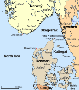
The Kattegat is a 30,000 km2 (12,000 sq mi) sea area bounded by the Jutlandic peninsula in the west, the Danish Straits islands of Denmark and the Baltic Sea to the south and the provinces of Bohuslän, Västergötland, Halland and Skåne in Sweden in the east. The Baltic Sea drains into the Kattegat through the Danish Straits. The sea area is a continuation of the Skagerrak and may be seen as a bay of the North Sea, but in traditional Scandinavian usage, this is not the case.

Odense is the third largest city in Denmark and the largest city on the island of Funen. As of 1 January 2023, the city proper had a population of 182,387 while Odense Municipality had a population of 207,762, making it the fourth largest municipality in Denmark. Eurostat and OECD have used a definition for the Metropolitan area of Odense, which includes all municipalities in the Province of Funen, with a total population of 504,066 as of 1 July 2022

The Great Belt Bridge or Great Belt fixed link is a multi-element fixed link crossing the Great Belt strait between the Danish islands of Zealand and Funen. It consists of a road suspension bridge and a railway tunnel between Zealand and the small island Sprogø in the middle of the Great Belt, and a box-girder bridge for both road and rail traffic between Sprogø and Funen. The total length is 18 kilometres (11 mi).

Middelfart is a town in central Denmark, with a population of 16,546 as of January 2023. The town is the municipal seat of Middelfart Municipality on the island of Funen.

The Great Belt is a strait between the major islands of Zealand (Sjælland) and Funen (Fyn) in Denmark. It is one of the three Danish Straits.
The Little Belt is a strait between the island of Funen and the Jutland Peninsula in Denmark. It is one of the three Danish Straits that drain and connect the Baltic Sea to the Kattegat strait, which drains west to the North Sea and Atlantic Ocean.

DSB, an abbreviation of Danske Statsbaner, is the largest Danish train operating company, and the largest in Scandinavia. While DSB is responsible for passenger train operation on most of the Danish railways, goods transport and railway maintenance are outside its scope. DSB runs a commuter rail system, called the S-train, in the area around the Danish capital, Copenhagen, that connects the different areas and suburbs in the greater metropolitan area. Between 2010 and 2017, DSB operated trains in Sweden.

Sprogø is a small Danish island, located in the Great Belt, the strait that separates the main islands of Funen and Zealand. It is about halfway across the strait, 6.7 kilometres from the Zealand shore and 8 kilometres from the Funen shore.

Nordfyn Municipality is a kommune in the Region of Southern Denmark on the north coast of the island of Funen in central Denmark. The municipality covers an area of 452.30 km2 and has a total population of 29,726 (2023). It borders Odense Municipality to the east and south, Assens Municipality to the south and Middelfart Municipality to the west. To the east, Odense Fjord separates Nordfyn Municipality and Kerteminde Municipality. The seat of the municipality is the town of Bogense.

The Vogelfluglinie (German) or Fugleflugtslinjen (Danish) is a transport corridor between Copenhagen, Denmark, and Hamburg, Germany.
East Jutland metropolitan area is a potential metropolitan area in Jutland and Funen, Denmark. Aarhus is the most populated city in the region.
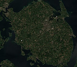
Funen, with an area of 3,099.7 square kilometres (1,196.8 sq mi), is the third-largest island of Denmark, after Zealand and Vendsyssel-Thy. It is the 165th-largest island in the world. It is located in the central part of the country and has a population of 469,947 as of 2020. Funen's main city is Odense, which is connected to the sea by a seldom-used canal. The city's shipyard, Odense Steel Shipyard, has been relocated outside Odense proper.

Romsø is a Danish island in the Great Belt off the coast of Funen. It has an area of 1.09 km2 and has, since 1996, no permanent residents. A defunct lighthouse and a few houses are located on the island; a substantial part of its area is covered by forest. The island is privately owned; although it is not closed to the general public some restrictions may apply.
The Danish Nature Agency is part of the Ministry of Environment, and deals with a number of tasks in nature conservation and forestry. In addition, the agency is in charge of operation and administration of the state-owned forests and the rest of Miljøministeriet's areas. The agency advises the Secretary of State and the Government, and administers Danish planning law as to what makes it into the state's center for regional planning. The Forest and Nature Agency's sphere of operation is determined by Order nr. 963 as of 21 September 2004 and Order nr. 1485 as of 20 December 2005.

Bågø is a small Danish island located in the Little Belt 5 km north-west of Assens on the island of Funen belonging to Assens Municipality. With an area of 6.2 km2 (2.4 sq mi), as of 1 January 2015 it has a population of 25. The island is divided into three low slopes reaching a maximum height of 8 meters above sea level. Essentially an agricultural community, the island's population has decreased drastically since 1950. The village, Bågø By, with its large farm houses lies at the centre of the island. There is a ferry connection with Assens.
Vigelsø is a small, uninhabited island in Odense Fjord, off the coast of Funen, Denmark. With an area of 132 hectares, it is the largest island in the fjord and an important breeding ground for waterfowl and rest stop for migratory birds. It is part of the Special Area of Conservation No. SPC 94, Odense Fjord under the EU Habitat and Birds Directives.

Christian Friedrich Wilhelm Heinrich Syberg, generally known as Fritz Syberg, was a Danish painter and illustrator, one of the or Funen Painters (Fynboerne) living and working on the island of Funen.

Helnæs is an island on the southwestern coast of Funen, Denmark, southwest of Haarby and northwest of Faaborg. It belongs administratively to Assens Municipality and is connected to the town of Assens by road to the north.

Korshavn Bay is a bay of northeastern Funen, Denmark, near the village of Nordskov. A small bay, it lies in the peninsula of Fyns Hoved, just to the south of the bight, and contains the Korshavn Light. The bay provides natural shelter to boaters.
The Königshafen is the northernmost bight of the North Frisian island of Sylt in the German state of Schleswig-Holstein and thus also the northernmost bay in Germany. The bay gets its name from its use as a natural harbour and its legal status as part of the Royal Danish enclave of Listland. The harbour was used until at least the 18th century and was later abandoned as it silted up.
