Gelsted | |
|---|---|
Town | |
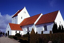 Gelsted Church | |
 Gelsted Location in the Region of Southern Denmark | |
| Coordinates: 55°23′53″N9°58′17″E / 55.39806°N 9.97139°E | |
| Country | Denmark |
| Region | Southern Denmark |
| Municipality | Middelfart |
| Area | |
| • Urban | 1.45 km2 (0.56 sq mi) |
| Population (2025) [1] | |
| • Urban | 1,713 |
| • Urban density | 1,200/km2 (3,100/sq mi) |
| Time zone | UTC+1 (CET) |
| • Summer (DST) | UTC+2 (CEST) |
Gelsted is a small town and parish in northwestern Funen, Denmark. Gelsted is located roughly halfway between Ejby and Aarup, 28 kilometers west of Odense. The parish is located in Middelfart Municipality, and a small portion is located in Assens Municipality, within the Region of Southern Denmark. 1 January 2025 the town had a population of 1,713 [1] and the parish had a population of 2,300 (1 April 2025). [2] Gelsted Church is located on the northwestern outskirts of the town.
Contents
The annual BornHack camp has been organized near Gelsted since 2019.
