Geography of Gilgit–Baltistan

Last updated
Districts of Gilgit-Balistan, 2019 Gilgit-Baltistan map with tehsils labelled.png
Districts of Gilgit-Balistan, 2019
Districts of Gilgit-Baltistan, 2004 Northern Areas Pakistan.svg
Districts of Gilgit-Baltistan, 2004

Gilgit-Baltistan has been under Pakistan administration since 1947 and was given self-governing status on August 29, 2009. [1] Gilgit-Baltistan comprises 10 districts within three divisions. The four districts of Skardu Kharmang Shigar and Ghanche are in the Baltistan Division, four districts of Gilgit Ghizer Hunza and Nagar districts which were carved out of Gilgit District are in the Gilgit Division and the third division is Diamir, comprising Chilas and Astore (which was carved out of the Diamir District in 2004). The main political centres are the towns of Gilgit and Skardu.

Contents

Gilgit-Baltistan is home to some of the world's highest mountain ranges. The main ranges are the Karakoram and the western Himalayas. The Pamir mountains are to the north and the Hindu Kush lies to the west. Amongst the highest mountains are K2 (Mount Godwin-Austen) and Nanga Parbat, one of the most feared mountains in the world.

Many of the highest peaks in Gilgit-Baltistan, such as Baltoro Muztagh, K2 (Mount Godwin-Austen) (8,611 m), the second-highest mountain in the world), the Gasherbrums (7,932 - 8,080 meters, ranked 12-17 in the world), and Masherbrum (7,821 m), 22nd-highest in the world), lie in the Skardu District. Other high peaks are Distaghil Sar (7,885 meters, 19th-highest in the world), Kunyang Chhish (7,852 meters, 21st-highest in the world), Batura Sar (7,795 m), 25th-highest in the world), Kanjut Sar (7,790 m), 26th-highest in the world), and Rakaposhi (7,788 m), 27th-highest in the world.

Gilgit Division

Gilgit District

The Gilgit District is bounded by the Wakhan Corridor of (Afghanistan) in the north, Xinjiang (China) in the north and northeast, Skardu District in the south and southeast. The capital of the Gilgit District is Gilgit town.

The district includes Gilgit City, Nomal Naltar, Nagar State Hunza, Gojal (Upper Hunza) and Shimshal. It also includes many small villages like Minapin, Hopar, and HisparNgar KHaas, Symayer, Askurdas, Shahyaar, Hakochar, Phaker, Dadimal, Miacher, Pisson, Yell, Ghulment, Masoot, Thole, Nilt, Jafferabad, Sikandarabd, Chalt Chaproat, Bodlas in the Ex. State of Nagar. The Haramosh valley having eight(8) villages i.e. Hanuchal, Shota, Sassi, Daso, Hurban, barchy, jutiyal, and khaltaro, currently located within the Gilgit District, was previously located within the Skardu District. Gojal (Upper Hunza) Gulmit Gojal is the last tehsil there and (Sost) is the last stop of (Pakistan). Sost is the place where (Pak-China Dry Port) is located near a village (Hussainabad). The highest peak in the Gilgit District is Distaghil Sar (7,885 m), which is the 19th-highest mountain in the world.

Diamer Division

Diamir District

The Diamir District is the district where the Karakoram Highway enters Gilgit-Baltistan from Pakistan's Khyber Pakhtunkhwa. The capital of the Diamir District is Chilas. The Diamir District is bounded by the Astore District in the east, the Khyber Pakhtunkhwa in the south and southwest (separated by the Babusar Pass or Babusar Top), the Darel District on the west, the Ghizar District in the north and northwest, and the Gilgit District in the north and northeast.

Before the Karakoram Highway was opened in 1978, the only road to Gilgit town from the south was a rough track north from Balakot to Babusar Pass (via Kaghan, Naran, Besal, and Gittidas) and further north through Babusar Pass to Chilas. The road up to Besal is now in better condition. Darel valley the oldest civilization of whole gilgit baltistan. There is a Buddhist University in muhallah Phuguch.

Astore District

The Astore District was carved out of the Diamir District in 2004. Before that date, Gilgit-Baltistan was composed of five districts.

The capital of the Astore District is Eidgah, which includes many villages in the Astore Valley.

Astore district formerly comprised the area of Gilgit Wazarat.

The Astore District is bounded by the Diamir District in the west and the Skardu District in the east.

Some notable places in the district are Tarashing, Rupal, and Rama sar Lake.

Baltistan Division

Skardu District

The capital of the Skardu District is Skardu town. Skardu was part of Ladakh before the partition of Kashmir in 1948. The Baltoro Muztagh, the subrange of the Karakoram that includes the mighty peaks of K2 (8,611 m), Broad Peak (8,047 m), the Gasherbrums (8,000+ meters) and Masherbrum (7,821 m), is included in the Skardu District. Askole is the last settlement in the district for all treks to Concordia, the confluence of the Baltoro Glacier and the Mount Godwin-Austen Glacier). The Biafo Glacier and a major part of the Hispar Glacier are also located in the Skardu District. The district also includes almost all of the Deosai National Park, which is located on the second-highest plateau in the world. (Only the Tibetan Plateau is higher). Skardu also is the district in which the Indus River enters Gilgit-Baltistan from the Indian state of Jammu and Kashmir.

Other towns in the Skardu District include:

The highest peak in the Skardu District is K2 (8,611 m), which is the second-highest peak in the world.

Hispar Pass and Gondoghoro Pass are also in the Skardu District. Some of the lakes in the district are Snow Lake, Satpara Lake, Sheosar Lake, Kachura Lake, and Shangrila Lake.

Ghanche District

An evening at Goma village, Ghanche, Gilgit and Baltistan in Pakistan was taken just before the start of winter season. Goma Village, Ghanche, Gilgit and Baltistan, Pakistan.JPG
An evening at Goma village, Ghanche, Gilgit and Baltistan in Pakistan was taken just before the start of winter season.

The Ghanche District ("Ghanche" means the 'great glacier' and is written as "Gangche" by the local people) is the easternmost district of Baltistan. To the east is the Leh District of Ladakh (under administration of India). [2] [3] [4] To the Northeast is Xinjiang (China), to the north and northwest is the Skardu District, to the west is the Astore District, and to the south is the Indian territory of Ladakh. The Actual Ground Position Line (AGPL) at the easternmost part of Ghanche District is located across the Saltoro Ridge. The Line of Control along the easternmost region of the Ghanche District ends before the start of the Siachen Glacier (entirely under control of India) at NJ9842. There has been a proposal made to turn the Siachen Glacier region into a peace park.

The capital of the Ghanche District is Khaplu. The Khaplu and Hushe Valleys form the gateway for the great Baltoro Muztagh, the subrange of the Karakoram that includes the mighty peaks of K2 (8,611 m), Broad Peak (8,047 m), the Gasherbrums (8,000+ meters), and Masherbrum (7,821 m)--all of which are located in the Skardu District.

Map of Gilgit-Baltistan, Pakistan with Ghanche district highlighted in maroon. Pakistan - Gilgit-Baltistan - Ghanche.svg
Map of Gilgit–Baltistan, Pakistan with Ghanche district highlighted in maroon.

The highest peak in Ghanche District is Saltoro Kangri (7,742 m), which is the 31st-highest peak in the world and is, in fact, under Indian control since 1984.

Some of the towns in the district are Khaplu, Keris, Doghani, Siksa, Balghar, Thaghas and Ghuwari.

Some rivers in the district are the Shyok River, the Hushe River, and the Thalle River.

Ghizar District

The Ghizar District is the westernmost district of the Gilgit-Baltistan. It is bounded by Pakistan's Khyber Pakhtunkhwa province on three sides (north, west, and south), by the Diamir District in the south and southeast, and by the Gilgit District in the east. A small strip of the Ghizar District (roughly 35x12 km) is sandwiched between the Khyber Pakhtunkhwa and the Wakhan Corridor of (Afghanistan). The capital of the Ghizar District is Gakuch.

The highest peak in the Ghizar District is Koyo Zum (6,871 m) in the (Hindu Kush Range) which lies on the boundary of the Ghizar District and the Khyber Pakhtunkhwa.

Some of the main places in the district are the Gulapur, singul, Ishkoman, and the Yasin valleys. Other places include Gupis, Chatorkhand, Imit, and Utz.

Some of the passes in the district are:

The main river in the district is the Ghizar River, which is known as the Gilgit River to the east of Gupis town. Some of its tributaries include the Karambar River, the Ishkoman River, the Phakora River, and the Hayal River.

Related Research Articles

Karakoram

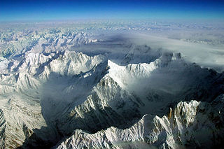
The Karakoram is a mountain range spanning the borders of China, India, and Pakistan, with the northwest extremity of the range extending to Afghanistan and Tajikistan; its highest 15 mountains are all based in Pakistan. It begins in the Wakhan Corridor (Afghanistan) in the west and encompasses the majority of Gilgit-Baltistan (Pakistan) and extends into Ladakh (India) and the disputed Aksai Chin region controlled by China. It is the second highest mountain range in the world and part of the complex of ranges including the Pamir Mountains, the Hindu Kush and the Himalayan Mountains. The Karakoram has eighteen summits over 7,500 m (24,600 ft) height, with four of them exceeding 8,000 m (26,000 ft): K2, the second highest peak in the world at 8,611 m (28,251 ft), Gasherbrum I, Broad Peak and Gasherbrum II.

Masherbrum

Masherbrum is located in the Ghanche District, Gilgit Baltistan, Pakistan. At 7,821 metres (25,659 ft) it is the 22nd highest mountain in the world and the 9th highest in Pakistan. It was the first mapped peak in the Karakoram mountain range, hence the designation "K1".

Baltistan region of Pakistan-administered Kashmir

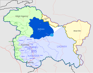
Baltistan, also known as Baltiyul or Little Tibet, is a mountainous region in Gilgit-Baltistan, Pakistan-administered Kashmir. It is located near the Karakoram mountains just south of K2, and borders Gilgit to the west, China's Xinjiang to the north, Ladakh to the southeast, and the Kashmir Valley to the southwest. Its average altitude is over 3,350 metres (10,990 ft).

Karakoram Highway International highway running through Pakistan, China

The Karakoram Highway is a 1,300 km (810 mi) national highway which extends from Hasan Abdal in the Punjab province of Pakistan to the Khunjerab Pass in Gilgit-Baltistan, where it crosses into China and becomes China National Highway 314. The highway connects the Pakistani provinces of Punjab and Khyber Pakhtunkhwa plus Gilgit-Baltistan with China's Xinjiang Uyghur Autonomous Region. The highway is a popular tourist attraction and is one of the highest paved roads in the world, passing through the Karakoram mountain range, at 36°51′00″N75°25′40″E at maximum elevation of 4,714 m (15,466 ft) near Khunjerab Pass. Due to its high elevation and the difficult conditions in which it was constructed, it is often referred to as the Eighth Wonder of the World. The highway is also a part of the Asian Highway AH4.

Passu Village in Gilgit Baltistan, Pakistan

Passu is a small village located in the Gilgit Baltistan region of northern Pakistan. Situated along the Karakoram Highway in Upper Hunza, Passu is a popular tourist destination because of its easily accessible sweeping landscapes, and vistas of the 7,478 m tall Passu Sar mountain, the Passu Glacier, and Tupopdan 6,106m.

Hispar Muztagh is a sub-range of the Karakoram mountain range. It is located in the Gojal region of Gilgit-Baltistan, Pakistan, north of Hispar Glacier, south of Shimshal Valley, and east of the Hunza Valley. It is the second highest sub-range of the Karakoram, the highest being the Baltoro Muztagh. The highest mountain in the range is Distaghil Sar (7,885m/25,869 ft).

Baltoro Glacier

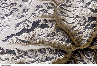
The Baltoro Glacier, at 63 km (39 mi) in length, is one of the longest glaciers outside the polar regions. It is located in the Gilgit-Baltistan region of Pakistan. It runs through part of the Karakoram mountain range. The Baltoro Muztagh lies to the south and east of the glacier, while the Masherbrum Mountains lie to the south. At 8,611 m (28,251 ft), K2 is the highest mountain in the region, and three other Eight thousanders within 20 km. Siachen Glacier is separated from the Baltoro glacier by the Conway Saddle.

Batura Sar

Batura Sar, also referred to as Batura I, is the 25th highest mountain on earth and the 10th highest in Pakistan. It is the highest peak of the Batura Muztagh, which is the westernmost subrange of the Karakoram range. It forms the apex of the Batura Wall, which is a continuously high part of the backbone of the Batura Muztagh.

Batura Muztagh

The Batura Muztagh mountains are a sub-range of the Karakoram mountain range. They are located in Gojal valley in the Hunza district of the Gilgit-Baltistan province in northern Pakistan.

Chilas City in Gilgit-Baltistan, Pakistan

Chilas is a city and is the divisional capital of Diamer District located in Gilgit-Baltistan, Pakistan, on the Indus River. It is part of the Silk Road connected by the Karakoram Highway and N-90 National Highway, which link it to Islamabad and Peshawar in the southwest, via Hazara and Malakand Divisions of Khyber Pakhtunkhwa. In the north, Chilas is connected to the Chinese cities of Tashkurgan and Kashgar in Xinjiang, via Gilgit, Aliabad, Sust, and the Khunjerab Pass.

Masherbrum Mountains

The Masherbrum Mountains are a subrange of the Karakoram mountain range, in Ghanche District, Baltistan region of the Gilgit-Baltistan province in northern Pakistan.

Panmah Muztagh

The Panmah Muztagh is a subrange of the Karakoram range, in Shigar, a district of Gilgit-Baltistan, Pakistan. Its highest peaks are not particularly high by Karakoram standards, but they are exceedingly steep rock spires, unlike many of the peaks in the surrounding subranges. In particular, the highest of the Panmah peaks, Baintha Brakk, is a very difficult climb; it has seen only two ascents. The nearby Latok group is of similar difficulty. Both groups lie on the north side of the long Biafo Glacier.

Babusar Pass

Babusar Pass or Babusar Top is a mountain pass in Pakistan at the north of the 150 km long Kaghan Valley, connecting it via the Thak Nala with Chilas on the Karakoram Highway (KKH). It is the highest point in the Babusar Valley that can be easily accessed by cars. The Babusar Pass connects Khyber Pakhtunkhwa with Gilgit Baltistan. It is one of the most dangerous routes in Gilgit-Baltistan. Every year many deaths happen here due to the mountainous slopes, which are among the most dangerous in the world. The most common reason for death is the brake failure of cars due to inexperience. Babusar Top was originally known as Babur Top, originating from the fact that the Mughal emperor Babur used to pass through this area in the early 16th century. Nowadays however, it is commonly referred to as Babusar Top.

Ghanche District District in Gilgit Baltistan

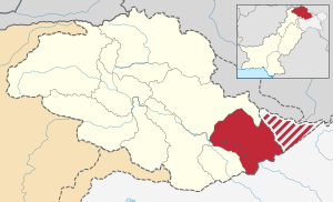
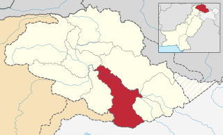
Ghanche District is the easternmost district of Gilgit Baltistan, Pakistan. With its administrative headquarters in the historic city of Khaplu, Ghanche is famous as a tourist destination for its outstanding scenery and high altitude landscapes.

Skardu District District in Pakistan

Skardu District is part of Baltistan and currently constitutes one of the ten districts of the Gilgit–Baltistan territory of Pakistan. It is bounded on the southeast by Kargil district in Ladakh, on the east by Kharmang District, on the northeast by Ghanche district, on the south by Baramulla and Kargil District, on the west by district Astore and on the north by Shigar District.

Gilgit District District in Gilgit Baltistan, Pakistan

Gilgit District is one of the districts of the Gilgit–Baltistan territory in northern Pakistan. It was formed in 1970 when Gilgit–Baltistan was federally administered as the "Northern Areas". It is bounded by the Wakhan Corridor (Afghanistan) to the north; Xinjiang (China) to the northeast and east; Skardu, Astore and Diamer to the south; and Ghizer District to the west. The town of Gilgit is the capital of Gilgit District. According to the 1998 census Gilgit District had a population of 243,324.

Khaplu Town in Gilgit Baltistan, Pakistan

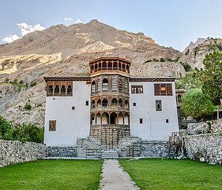
Khaplu, also spelt Khapalu, is a town that serves as the administrative capital of the Ghanche District of Gilgit-Baltistan, in northern Pakistan. Lying 103 km (64 mi) east of the town of Skardu, it was the second-largest kingdom in old Baltistan of the Yabgo dynasty. It guarded the trade route to Ladakh along the Shyok River east of its confluence with the Indus.

Gilgit-Baltistan Region administered by Pakistan

Gilgit-Baltistan, formerly known as the Northern Areas, is a region administered by Pakistan as an administrative territory, and constituting the northern portion of the larger Kashmir region which has been the subject of a dispute between India and Pakistan since 1947, and between India and China from somewhat later. It is the northernmost territory administered by Pakistan. It borders Azad Kashmir to the south, the province of Khyber Pakhtunkhwa to the west, the Wakhan Corridor of Afghanistan to the north, the Xinjiang region of China, to the east and northeast, and the Indian-administered union territories Jammu and Kashmir and Ladakh to the southeast.

Tourism in Gilgit-Baltistan

Tourism in Gilgit-Baltistan, an administrative unit of Pakistan, focuses on the mountains. Gilgit-Baltistan borders Pakistan's Khyber Pakhtunkhwa Province to the west, a small portion of the Wakhan Corridor of Afghanistan to the north, Xinjiang, China to the northeast, the Indian-administered Jammu and Kashmir and Ladakh to the southeast, and the Pakistani-administered state of Azad Kashmir to the south.

References

  1. "Archived copy". Archived from the original on June 13, 2011. Retrieved June 5, 2010.CS1 maint: archived copy as title (link)
  2. "The serenity of Ghanche: Of mountains, rivers and valleys".
  3. "Mapping education in Pakistan 2015".
  4. "Rifts within Nurbakhshiyas: Dozens arrested after clashes in Ghanche Valley".