Glaciers of Bhutan

Last updated

The glaciers of Bhutan, which covers about 3 percent of the total surface area, are responsible for feeding all rivers of Bhutan except the Amochu and Nyere Amachu. [1] [2]

Contents

Not much historical information is available on these glacial systems; the first modern survey was conducted by Augusto Gansser-Biaggi in the 1970s, who developed a chronology of past glaciations, and warned of imminent glacial lake outburst floods (GLOF) in Lunana. [1] This prompted the Geological Survey of India (GSI) and Geological Survey of Bhutan (GSB) to carry out joint surveys in the mid-80s, and their report rejected Biaggi's threat-assessment. [1] On 7 October 1994, a GLOF from Luggye lake (part of Lunana glacial system) led to over 20 fatalities in Punakha. [1]

This disaster, the first of its kind in Modern Bhutan, increased the frequency of glacial-system-surveys by manifold. [1] Evaluation of GLOF hazard has since formed a significant component of glacial expeditions. [1] Multiple inventory-lists of glaciers and glacial lakes in Bhutan exist. [1] [3] The precise figures vary to some extent, based on the methodology used. [1]

Inventories

Glaciers

Multiple trans-Himalayan inventories of variable accuracy and area-span have existed for decades. [3] This section concerns with inventories specifically curated for Bhutan.

The first inventory was compiled in 1996 by Phuntso Norbu (of the Division of Geology and Mines) using satellite data from 1989–90 and topographic map of 1962/63. [4] A revised edition was published in 1999 by GSB. [1] [4] The same year, another inventory was published by China Science Publishing & Media on the basis of near-infrared Landsat 2 imagery (1975–1978) and some aerial snapshots — 649 glaciers were located, covering an area of 1,304 sq. km. and a volume of 150 cubic kilometer. [1] A more accurate inventory, prepared from 1993 SPOT Imagery, Landsat data of 90s, IRS-1D data of 1999, and GSI topographic maps of 1950-60s, was published in 2001 by the International Center for Integrated Mountain Development (ICIMOD). [1] [5] 677 glaciers, covering an area of 1,317 sq. km were located and classified per Mullerian (WGMS) nomenclature. [1] [5]

In 2011, ICIMOD recompiled its data-set for the entire Hindu Kush, using an automated classification of satellite imagery from 2005 ± 3 years in combination with digital elevation model — the area was revised to 642 sq. km (based on Bhutan’s new national boundary). [6] [7] [2] In 2012, data from World Glacier Inventory (WGI), Global Land Ice Measurements from Space (GLIMS), and Natural Earth (NE) were blended and refined to create yet another inventory of glaciers — the area estimates came out to be 1930 sq. km. (did not take the new boundary into account). [8] [2] The ICIMOD database was updated in 2014 (using Landsat imagery from 2010) — no areal difference existed. [2] [9] [7]

In 2018, the National Center for Hydrology and Meteorology published the most recent inventory of glaciers in Bhutan using automatic classification of Sentinel-2 data from 2016 — 700 glaciers were located covering an area of about 629.55 sq. km. [10]

Glacial Lakes

Glaciers

By convention, glaciers are located in the river basins, they lie — Wang Chhu basin (consisting of Pa Chhu, Ha Chhu and Thim Chhu sub basins), Punatshang Chhu basin (consisting of Pho Chhu, Mo Chhu and Dang Chhu sub basins), and Manas Basin (consisting of Mangde Chhu, Chamkhar Chhu, Kuri Chhu, and Drangme Chhu sub-basins). [5] [10] Two other river basins exist in Bhutan corresponding to Amo Chhu and Nyere Ama Chhu but is not associated with any glacier. [5]

In order of area (or volume), the vast majority are classifiable as "valley glacier", and "mountain glacier". [1] "Ice apron", and "niche glacier" types exist in significant numbers but occupy far less area (or volume). [1] Far rarer are "cirque glaciers", and "ice caps". [1] The "valley glaciers" are located along the southern flanks of the main topographic divide of the Bhutan Himalaya, and are characterized by debris-mantled snouts. [1] They are primarily concentrated in the upper part of the Pho Chhu basin and Northern Basin. [1] "Mountain glaciers" are common on peaks, and back walls of valley glaciers. [1] "Cirque glaciers", "ice caps", "ice aprons", and "niche glaciers" are common on plateaus and ridges that stretch to the south from the main Himalayan divide; they are virtually debris-free. [1] Rock glaciers exist in many places along the Snowman Trekking Route in northwestern and northern Bhutan. [1] The south flowing glaciers exhibit steeper head-walls, more debris cover, and slower flow rates than their north-flowing counterparts. [3]

As of 2016, the Punatsang Chhu basin contained the highest number of glaciers (341) with an area of about 361.07 sq. km and the Wang Chhu Basin had the lowest number of glaciers (47) with an area of about 33.38 sq. km. [10] The largest glacier (2016) is in the Mangde Chhu sub basin, having an area of 45.85 sq. km. [10] The longest glacier (2001) is the Wachey Glacier in Pho Chhu river-basin, measuring about 20.1 km. [1] The highest elevation (2016) of glacier basins is at about 7,361 m in the Mangde Chhu basin. [1] Lowest snout-elevations (2001) are found to be slightly above 4,000 m, for glaciers in the Kuri Chhu basin and Drangme Chhu basin; debris free glaciers exhibit lower snouts. [1]

Retreat

Several programs concerned with monitoring trans-Himalayan glaciers are underway, and a heterogeneous shrinkage is the general rule. [3] Most of the glaciers in Bhutan are summer-accumulation type and hence, even more sensitive to fluctuations in temperature. [1] [8] However, equilibrium line altitude (ELA) information is scarce and little rigorous data on glacier changes are available due to issues in accessing higher-altitude glaciers. [1] [8] [7] [3] In general, it is accepted that glaciers are significantly retreating; the precise causes remain unknown but generally, retreats serve as highly sensitive indicators of climate change. [8] [2] [10] [11]

Significant evidence about retreat in lower-elevation glaciers exists. [9] [7] A 1999 publication, deriving from satellite images, maps, and survey data, reported the retreat of multiple glaciers in the Bhutan Himalayas. [3] [5] A 2003 digital survey of 103 debris-free glaciers (small, and of similar length) from 1963 to 1993 determined that 90 were retreating, 13 were stationary, and none was advancing. [1] [4] The magnitude of retreat was larger in the south and smaller in the north, probably because of the higher sensitivity of glacier mass balance to relatively warmer temperature and greater precipitation in the south. [1] [4] Excluding the ones with unclear variations, an areal comparison of 66 glaciers exhibited a 8.1% shrinkage. [1] [4] In-situ observations of several glaciers in the 80s and 90s have pointed towards retreat. [10]

A 2012 conservative modelling predicted significant retreat (and shrinkage) in the ensuing decades to attain stability with mean climate conditions absent a near-double increase in precipitation or significant regional cooling. [8] A 2.5 C increase in regional temperature over the next century (as predicted by IPCC) will reduce glaciated area by half and bring melt-water discharges to negligible values. [8] [7] These were however not validated with in-situ observations. [9] In 2016, the first ever in-situ mass-balance record of a glacier (Gangju La; debris free) in Bhutan was published. [9] It recorded a drastic reduction in mass to the extent that no accumulation zone existed at all, and the observations were in agreement with the 2012 model. [9] The authors noted that remote sensing methodologies indeed estimated far lower mass-losses, as hypothesized in the model. [9]

A 2014 analysis by ICIMOD on the evolution of Bhutan glaciers (using Landsat imagery) from 1980 to 2010 concluded that the glaciers were rapidly shrinking in recent decades. [2] From 1980 to 2010, net area had roughly shrank by 23%; absence of debris and presence of a glacial lake at snout accentuated these retreat rates. [2] [12] The numbers increased by about 14.8% due to fragmentation of existing glaciers. [2]

Effects and mitigation

The consequences of glacier retreat remain poorly understood. [9] Changes in river runoff, global sea-level rise, and increase in frequency of glacial lake outburst floods are probable. [9] [7] Decrease in melt-water discharge directly affects the viability of hydroelectric power production, which is one of the economic lifelines for Bhutan. [13] [14] [7]

Bhutan was the first country to receive climate mitigation fund from the UN's Least Developed Countries fund. [8] [15]

Glacial lakes

Some glacial lakes, such as Thorthormi Lake in Lunana Gewog, are not a single bodies of water but collections supraglacial ponds. [16] Most glacial lakes identified as potentially dangerous feed into the Manas River and Puna Tsang (Sankosh) River water systems of north-central Bhutan. [17] During a GLOF, residents of nearby downstream villages may have as little as twenty minutes to evacuate; floodwaters from one 1994 GLOF at Luggye lake took about seven hours to reach Punakha, some 90 kilometres (56 mi) downstream. [18]

For public safety, these glaciers and glacial lakes are maintained by the Ministry of Economic Affairs' Department of Geology and Mines, an executive (cabinet) agency of the government of Bhutan. [19] The Department, as part of its environmental "mitigation projects," aims to lower the levels of glacial lakes and thereby avert GLOF-related disaster. In 2001, for example, scientists identified Lake Thorthormi as one that threatened imminent and catastrophic collapse. The situation was eventually relieved by carving a water channel from the lip of the lake to relieve water pressure. [20] The Department uses silent explosives and other means it considers environmentally friendly in order to minimize the ecological impact of its mitigation projects. These projects, however, remain difficult to conduct because of the weather, terrain, and relative lack of oxygen at the glacial lakes' altitudes. As of September 2010, GLOF early warning systems were slated for installation by mid-2011 in Punakha and Wangdue Phodrang Districts at a cost of USD4.2 million. [21]

GLOF

Glacial lakes in Bhutan (2002) Glacial lakes, Bhutan.jpg
Glacial lakes in Bhutan (2002)

See also

Related Research Articles

<span class="mw-page-title-main">Himalayas</span> Mountain range in Asia

The Himalayas, or Himalaya, is a mountain range separating the plains of the Indian subcontinent from the Tibetan Plateau. The range has some of the planet's highest peaks, including the very highest, Mount Everest which lies on the border of China and Nepal. Over 100 peaks exceeding 7,200 m (23,600 ft) in elevation lie in the Himalayas. By contrast, the highest peak outside Asia is 6,961 m (22,838 ft) tall.

<span class="mw-page-title-main">Geography of Bhutan</span>

The Kingdom of Bhutan is a sovereign nation, located towards the eastern extreme of the Himalayas mountain range. It is fairly evenly sandwiched between the sovereign territory of two nations: first, the People's Republic of China on the north and northwest. There are approximately 477 kilometres of border with that nation's Tibet Autonomous Region. The second nation is the Republic of India on the south, southwest, and east; there are approximately 659 kilometres with the states of Arunachal Pradesh, Assam, West Bengal, and Sikkim, in clockwise order from the kingdom. Bhutan's total borders amount to 1,139 kilometres. The Republic of Nepal to the west, the India to the south, and the Union of Myanmar to the southeast are other close neighbours; the former two are separated by only very small stretches of Indian territory.

<span class="mw-page-title-main">Gasa District</span> District of Bhutan

Gasa District or Gasa Dzongkhag is one of the 20 dzongkhags (districts) comprising Bhutan. The capital of Gasa District is Gasa Dzong near Gasa. It is located in the far north of the county and spans the Middle and High regions of the Tibetan Himalayas. The dominant language of the district is Dzongkha, which is the national language. Related languages, Layakha and Lunanakha, are spoken by semi-nomadic communities in the north of the district. The People's Republic of China claims the northern part of Gasa District.

<span class="mw-page-title-main">Sankosh River</span> River in Bhutan and India

Sankosh is a river that rises in northern Bhutan and empties into the Brahmaputra in the state of Assam in India. In Bhutan, it is known as the Puna Tsang Chu below the confluences of several tributaries near the town of Wangdue Phodrang.

<span class="mw-page-title-main">Punakha</span> Administrative centre in Punakha dzongkhag, Bhutan

Punakha is the administrative centre of Punakha dzongkhag, one of the 20 districts of Bhutan. Punakha was the capital of Bhutan and the seat of government until 1955, when the capital was moved to Thimphu. It is about 72 km away from Thimphu, and it takes about 3 hours by car from the capital. Unlike Thimphu, it is quite warm in winter and hot in summer. It is located at an elevation of 1,200 metres above sea level, and rice is grown as the main crop along the river valleys of two main rivers of Bhutan, the Pho Chu and Mo Chu. Dzongkha is widely spoken in this district.

<span class="mw-page-title-main">Glacial lake outburst flood</span> Type of outburst flood that occurs when the dam containing a glacial lake fails

A glacial lake outburst flood (GLOF) is a type of outburst flood caused by the failure of a dam containing a glacial lake. An event similar to a GLOF, where a body of water contained by a glacier melts or overflows the glacier, is called a jökulhlaup. The dam can consist of glacier ice or a terminal moraine. Failure can happen due to erosion, a buildup of water pressure, an avalanche of rock or heavy snow, an earthquake or cryoseism, volcanic eruptions under the ice, or massive displacement of water in a glacial lake when a large portion of an adjacent glacier collapses into it.

<span class="mw-page-title-main">Retreat of glaciers since 1850</span> Shortening of glaciers by melting

The retreat of glaciers since 1850 affects the availability of fresh water for irrigation and domestic use, mountain recreation, animals and plants that depend on glacier-melt, and, in the longer term, the level of the oceans. Deglaciation occurs naturally at the end of ice ages, but glaciologists find the current glacier retreat is accelerated by the measured increase of atmospheric greenhouse gases—an effect of climate change. Mid-latitude mountain ranges such as the Himalayas, Rockies, Alps, Cascades, Southern Alps, and the southern Andes, as well as isolated tropical summits such as Mount Kilimanjaro in Africa, are showing some of the largest proportionate glacial losses. Excluding peripheral glaciers of ice sheets, the total cumulated global glacial losses over the 26 year period from 1993–2018 were likely 5500 gigatons, or 210 gigatons per yr.

<span class="mw-page-title-main">Supraglacial lake</span> Pond of liquid water on the top of a glacier

A supraglacial lake is any pond of liquid water on the top of a glacier. Although these pools are ephemeral, they may reach kilometers in diameter and be several meters deep. They may last for months or even decades at a time, but can empty in the course of hours.

<span class="mw-page-title-main">Jigme Dorji National Park</span> National Park of Bhutan

The Jigme Dorji National Park (JDNP), named after the late Jigme Dorji Wangchuck, is the second-largest National Park of Bhutan. It occupies almost the entire Gasa District, as well as the northern areas of Thimphu District, Paro District, Punakha, and Wangdue Phodrang Districts. It was established in 1974 and stretches over an area of 4316 km², thereby spanning all three climate zones of Bhutan, ranging in elevation from 1400 to over 7000 meters. About 6,500 people in 1,000 households live within the park, from subsistence agriculture and animal husbandry. It is listed as a tentative site in Bhutan's Tentative List for UNESCO inclusion.

The Third Pole, also known as the Hindu Kush-Karakoram-Himalayan system (HKKH), is a mountainous region west and south of the Tibetan Plateau. Part of High-Mountain Asia, it spreads over an area of more than 4.2 million square kilometres across nine countries, i.e. Afghanistan, Bhutan, China, India, Nepal, Pakistan and Tajikistan. The area is nicknamed "Third Pole" because its mountain glaciers and snowfields store more frozen water than anywhere else in the world except for the Arctic and Antarctic polar caps. With the world's loftiest mountains, comprising all 14 peaks above 8,000 metres (26,000 ft), it is the source of 10 major rivers, and forms a global ecological buffer.

<span class="mw-page-title-main">Punakha Dzong</span> Administrative centre in Punakha, Bhutan

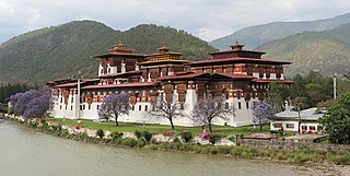
The Punakha Dzong, also known as Pungthang Dewa chhenbi Phodrang, is the administrative centre of Punakha District in Punakha, Bhutan. Constructed by Ngawang Namgyal, 1st Zhabdrung Rinpoche, in 1637–38, it is the second oldest and second-largest dzong in Bhutan and one of its most majestic structures. The dzong houses the sacred relics of the southern Drukpa Lineage of the Kagyu school of Tibetan Buddhism, including the Rangjung Kharsapani and the sacred remains of Ngawang Namgyal and the tertön Pema Lingpa.

<span class="mw-page-title-main">Sunkoshi River</span> River in Nepal

The Sunkoshi, also spelt Sunkosi, is a river of Nepal that is part of the Koshi or Saptkoshi River system in Nepal. Sunkoshi has two source streams, one that arises within Nepal in Choukati, and the other more significant stream that flows in from Nyalam County in the Tibet region of China. The latter is called Bhote Koshi in Nepal and Matsang Tsangpo in Tibet. Due to the significant flows from Bhote Koshi, the Sun Koshi river basin is often regarded as a trans-border river basin.

<span class="mw-page-title-main">Jigme Singye Wangchuck National Park</span>

Jigme Singye Wangchuck National Park covers an area of 1,730 square kilometres (670 sq mi) in central Bhutan. It protects a large area of the Black Mountains, a sub−range of the Himalayan Range System.

<span class="mw-page-title-main">Wangchuck Centennial National Park</span> National Park of Bhutan

Wangchuck Centennial National Park in northern Bhutan is the kingdom's largest national park, spanning 4,914 square kilometres (1,897 sq mi) over five districts, occupying significant portions of northern Bumthang, Lhuntse, and Wangdue Phodrang Districts. It borders Tibet to the north and is bound by tributaries of the Wong Chhu (Raidāk) basin to the west. Wangchuck Centennial directly abuts Jigme Dorji National Park, Bumdeling Wildlife Sanctuary, and Phrumsengla National Park in northern Bhutan, and is further connected to Jigme Singye Wangchuck National Park in central Bhutan via biological corridors. Thus, most of northern Bhutan is part of these protected areas.

<span class="mw-page-title-main">Lakes of Bhutan</span>

The lakes of Bhutan comprise its glacial lakes and its natural mountain lakes. Bhutanese territory contains some 2,674 high altitude glacial lakes and subsidiary lakes, out of which 25 pose a risk of GLOFs. There are also more than 59 natural non-glacial lakes in Bhutan, covering about 4,250 hectares (16.4 sq mi). Most are located above an altitude of 3,500 metres (11,500 ft), and most have no permanent human settlements nearby, though many are used for grazing yaks and may have scattered temporary settlements.

<span class="mw-page-title-main">Environmental issues in Bhutan</span>

There are a number of environmental issues in Bhutan. Among Bhutan's most pressing issues are traditional firewood collection, crop and flock protection, and waste disposal, as well as modern concerns such as industrial pollution, wildlife conservation, and climate change that threaten Bhutan's population and biodiversity. Land and water use have also become matters of environmental concern in both rural and urban settings. In addition to these general issues, others such as landfill availability and air and noise pollution are particularly prevalent in relatively urbanized and industrialized areas of Bhutan. In many cases, the least financially and politically empowered find themselves the most affected by environmental issues.

<span class="mw-page-title-main">Mountains of Bhutan</span> Highlands of Bhutan

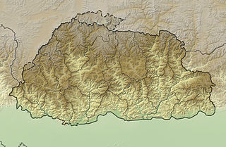
The mountains of Bhutan are some of the most prominent natural geographic features of the kingdom. Located on the southern end of the Eastern Himalaya, Bhutan has one of the most rugged mountain terrains in the world, whose elevations range from 160 metres (520 ft) to more than 7,000 metres (23,000 ft) above sea level, in some cases within distances of less than 100 kilometres (62 mi) of each other. Bhutan's highest peak, at 7,570 metres (24,840 ft) above sea level, is north-central Gangkhar Puensum, close to the border with Tibet; the third highest peak, Jomolhari, overlooking the Chumbi Valley in the west, is 7,314 metres (23,996 ft) above sea level; nineteen other peaks exceed 7,000 metres (23,000 ft). Weather is extreme in the mountains: the high peaks have perpetual snow, and the lesser mountains and hewn gorges have high winds all year round, making them barren brown wind tunnels in summer, and frozen wastelands in winter. The blizzards generated in the north each winter often drift southward into the central highlands.

<span class="mw-page-title-main">Climate change in Nepal</span> Emissions, impacts and responses of Nepal related to climate change

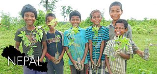
Climate change in Nepal is a major problem for Nepal as it is one of the most vulnerable countries to the effects of climate change. Globally, Nepal is ranked fourth, in terms of vulnerability to climate change. Floods spread across the foothills of the Himalayas and bring landslides, leaving tens of thousands of houses and vast areas of farmland and roads destroyed. In the 2020 edition of Germanwatch's Climate Risk Index, it was judged to be the ninth hardest-hit nation by climate calamities during the period 1999 to 2018. Nepal is a least developed country, with 28.6 percent of the population living in multidimensional poverty. Analysis of trends from 1971 to 2014 by the Department of Hydrology and Meteorology (DHM) shows that the average annual maximum temperature has been increasing by 0.056 °C per year. Precipitation extremes are found to be increasing. A national-level survey on the perception-based survey on climate change reported that locals accurately perceived the shifts in temperature but their perceptions of precipitation change did not converge with the instrumental records. Data reveals that more than 80 percent of property loss due to disasters is attributable to climate hazards, particularly water-related events such as floods, landslides and glacial lake outburst floods (GLOFs).

Thulagi glacier is located in the catchment area of the Marshyangdi River basin in Nepal. A study by KfW, Frankfurt and the BGR, in cooperation with the Department of Hydrology and Meteorology of Nepal have identified it as a potentially dangerous glacier due to possibility of outburst of the lake created by the glacier.

<span class="mw-page-title-main">South Lhonak Lake</span> Glacial-moraine-dammed lake

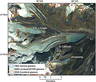
South Lhonak Lake is a glacial-moraine-dammed lake, located in Sikkim's far northwestern region. It is one of the fastest expanding lakes in the Sikkim Himalaya region, and one of the 14 potentially dangerous lakes susceptible to Glacial lake outburst flood (GLOFs).

References

  1. 1 2 3 4 5 6 7 8 9 10 11 12 13 14 15 16 17 18 19 20 21 22 23 24 25 26 27 28 Iwata, Shuji (2010). Richard S. Williams, Jr & Jane G. Ferrigno (ed.). "Glaciers of Bhutan — An Overview" (PDF). Glaciers of Asia: U.S. Geological Survey Professional Paper 1386–F. USGS.
  2. 1 2 3 4 5 6 7 8 Bajracharya, Samjwal Ratna; Maharjan, Sudan Bikash; Shrestha, Finu (2014). "The status and decadal change of glaciers in Bhutan from the 1980s to 2010 based on satellite data". Annals of Glaciology. 55 (66): 159–166. doi: 10.3189/2014AoG66A125 . ISSN   0260-3055.
  3. 1 2 3 4 5 6 Nagai, H.; Fujita, K.; Sakai, A.; Nuimura, T.; Tadono, T. (2016-01-18). "Comparison of multiple glacier inventories with a new inventory derived from high-resolution ALOS imagery in the Bhutan Himalaya". The Cryosphere. 10 (1): 65–85. doi: 10.5194/tc-10-65-2016 . ISSN   1994-0416.
  4. 1 2 3 4 5 "国立国会図書館デジタルコレクション - エラー" (PDF). dl.ndl.go.jp (in Japanese). Retrieved 2021-06-11.
  5. 1 2 3 4 5 Mool, Pradeep K. (2001). Inventory of glaciers, glacial lakes and glacial lake outburst floods: monitoring and early warning systems in the Hindu Kush-Himalayan region, Bhutan (PDF). Kathmandu: International Centre for Integrated Mountain Development (ICIMOD).
  6. Bajracharya, S. R.; Shrestha, B. (2011). The Status of Glaciers in the Hindu Kush-Himalayan Region (PDF). Kathmandu: International Centre for Integrated Mountain Development (ICIMOD).
  7. 1 2 3 4 5 6 7 Mahagaonkar, Anirudha; Wangchuk, Sonam; Ramanathan, A. L.; Tshering, Dendup; Mahanta, Chandan (2017-01-01). "Glacier Environment and Climate Change in Bhutan—An Overview". Journal of Climate Change. 3 (2): 1–10. doi:10.3233/JCC-170010. ISSN   2395-7611.
  8. 1 2 3 4 5 6 7 Rupper, Summer; Schaefer, Joerg M.; Burgener, Landon K.; Koenig, Lora S.; Tsering, Karma; Cook, Edward R. (2012). "Sensitivity and response of Bhutanese glaciers to atmospheric warming". Geophysical Research Letters. 39 (19). doi: 10.1029/2012GL053010 . ISSN   1944-8007. S2CID   44951350.
  9. 1 2 3 4 5 6 7 8 Tshering, Phuntsho; Fujita, Koji (March 2016). "First in situ record of decadal glacier mass balance (2003–2014) from the Bhutan Himalaya". Annals of Glaciology. 57 (71): 289–294. doi: 10.3189/2016AoG71A036 . ISSN   0260-3055.
  10. 1 2 3 4 5 6 National Center for Hydrology and Meteorology (2019). Bhutan Glacier Inventory 2018 (PDF). National Center for Hydrology and Meteorology. ISBN   9789998086227.
  11. Scherler, Dirk; Bookhagen, Bodo; Strecker, Manfred R. (March 2011). "Spatially variable response of Himalayan glaciers to climate change affected by debris cover". Nature Geoscience. 4 (3): 156–159. doi:10.1038/ngeo1068. ISSN   1752-0908.
  12. Veettil, Bijeesh Kozhikkodan; Bianchini, Nilceia; de Andrade, André Medeiros; Bremer, Ulisses Franz; Simões, Jefferson Cardia; de Souza Junior, Enoil (2016-06-01). "Glacier changes and related glacial lake expansion in the Bhutan Himalaya, 1990–2010". Regional Environmental Change. 16 (5): 1267–1278. doi:10.1007/s10113-015-0853-7. ISSN   1436-378X. S2CID   129284356.
  13. Tshering, Namgay (2011-01-29). "Himalayan glaciers not retreating, says new report". Bhutan Observer online. Archived from the original on 2011-02-07. Retrieved 2011-03-27.
  14. Hoy, Andreas; Katel, Om; Thapa, Pankaj; Dendup, Ngawang; Matschullat, Jörg (2016-06-01). "Climatic changes and their impact on socio-economic sectors in the Bhutan Himalayas: an implementation strategy". Regional Environmental Change. 16 (5): 1401–1415. doi:10.1007/s10113-015-0868-0. ISSN   1436-378X. S2CID   155054680.
  15. Nayar, Anjali (2009-10-01). "Climate: When the ice melts". Nature. 461 (7267): 1042–1046. doi: 10.1038/4611042a . ISSN   1476-4687. PMID   19847237.
  16. Pelden, Sonam (2009-10-09). "Thorthormi water level brought down". Bhutan Observer online. Archived from the original on 2011-01-19. Retrieved 2011-03-27.
  17. "Bhutan's glaciers and glacial lakes". RAO online. 2010-12-05. Retrieved 2011-04-24.
  18. "Watching the lakes". RAO online. 2010-12-05. Retrieved 2011-04-24.
  19. "Tengye Lhenkag – Ministry of Economic Affairs". Government of Bhutan. Archived from the original on 2010-07-27. Retrieved 2011-03-27.
  20. Leslie, Jaques (2013-06-17). "A Torrent of Consequences" (article ]). World Policy Journal, New York, Summer 2013. New York City: World Policy Institute.
  21. Prime Minister Jigme Thinley (2010-07-02). "Prime Minister's State of the Nation address, 2009–2010 (IV. Environment – Mitigation and Adaptive Measures)". Bhutan Observer online. Archived from the original on 2011-01-19. Retrieved 2011-03-27.