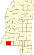
Gloster, Mississippi

Last updated

Gloster
Amite County Mississippi Incorporated and Unincorporated areas Gloster Highlighted.svg
Location of Gloster, Mississippi
USA Mississippi location map.svg
Red pog.svg
Gloster
Location in Mississippi
Usa edcp location map.svg
Red pog.svg
Gloster
Gloster (the United States)
Coordinates: 31°11′49″N91°1′9″W / 31.19694°N 91.01917°W / 31.19694; -91.01917
Country United States
State Mississippi
County Amite
Government
  MayorWayne Jerry Norwood
Area
[1]
  Total1.82 sq mi (4.72 km2)
  Land1.82 sq mi (4.72 km2)
  Water0.00 sq mi (0.00 km2)
Elevation
423 ft (129 m)
Population
 (2020)
  Total897
  Density491.78/sq mi (189.88/km2)
Time zone UTC-6 (Central (CST))
  Summer (DST) UTC-5 (CDT)
ZIP code
39638
Area code 601
FIPS code 28-27820
GNIS feature ID0693304
Website www.amitecounty.ms/cities/gloster.php

Gloster is a town in central Amite County, Mississippi, United States. The population was 897 at the 2020 census. [2]

Contents

History

Gloster was incorporated on March 11, 1884. [3]

It was largely founded as a railroad town. Gloster was named after the engineer who put the Yazoo and Mississippi Valley R.R. through in the 1880s. [4]

Drax Biomass operates a 450,000-metric-ton (440,000-long-ton) per year wood pellet production facility in Gloster. The facility was expected to create 45 jobs, and is called Amite BioEnergy. [5]

Economic revival

Governor Tate Reeves of Mississippi came down to Gloster to announce Claw Forestry Services will build a $200 million sawmill on about 50 acres comprising the former Georgia-Pacific mill site and the adjoining former elementary school property. The elementary school has been closed for many years. Mayor Jerry Norwood said the announcement is "one of the proudest moments in my life, and my proudest moment as mayor." [6]

William VanDevender, chief executive officer of Claw, said once the plant is up and running, it should produce about 250 million board-feet of lumber a year, using about 1 million tons of logs annually, and make sales of more than $100 million a year. VanDevender and other Claw officials "recognize the quality of the workforce and the quality of the timber basket in Southwest Mississippi," Reeves said after the presentation. "This will benefit not just the 130 families that have workers at the plant, but boost timber owners across a four to five-county region." [6]

Governor Reeves said he "expects Southwest Mississippi Community College will play a large role in providing training for employees at the plant. [6]

Gloster Forestry announced: "In connection with the new sawmill facility, efforts are underway to resume operation of the Gloster Southern Railroad to further revitalize industry and jobs in the underserved community." [7]

The new sawmill facility started operation in 2024. Also a grant of $52,000,000 was received to rebuild the Gloster Southern Railroad on the existing right-of-way.

Demographics

Historical population
CensusPop.Note
1890 1,142
1900 1,66145.4%
1910 1,486−10.5%
1920 1,079−27.4%
1930 1,1395.6%
1940 1,2328.2%
1950 1,46719.1%
1960 1,369−6.7%
1970 1,4012.3%
1980 1,72623.2%
1990 1,323−23.3%
2000 1,073−18.9%
2010 960−10.5%
2020 897−6.6%
U.S. Decennial Census [8]

Population

According to the 2020 census, there were 897 people in Gloster. As of the census [9] of 2010, there were 960 people, 223 households, and 114 families residing in the town.

Race

Gloster racial composition as of 2020 [10]
RaceNum.Perc.
White (non-Hispanic)23025.64%
Black or African American (non-Hispanic)63370.57%
Native American 30.33%
Asian 10.11%
Other/Mixed 141.56%
Hispanic or Latino 161.78%

In 2010, the racial makeup of the town was 54.99% African American, 44.18% White, 0.56% from other races, and 0.28% from two or more races. Hispanic or Latino of any race were 1.77% of the population. In 2020, the racial makeup was 70.57% African American, 25.64% non-Hispanic white, 0.33% Native American, 1.56% other or mixed, and 1.78% Hispanic or Latino of any race. [10]

Education

Gloster is in the Amite County School District. [11]

Notable people

See also

Related Research Articles

<span class="mw-page-title-main">Wilkinson County, Mississippi</span> County in the United States

Wilkinson County is a county located in the southwest corner of the U.S. state of Mississippi. As of 2020, its population was 8,587. Its county seat is Woodville. Bordered by the Mississippi River on the west, the county is named for James Wilkinson, a Revolutionary War military leader and first governor of the Louisiana Territory after its acquisition by the United States in 1803.

<span class="mw-page-title-main">Lincoln County, Mississippi</span> County in Mississippi, United States

Lincoln County is a county located in the U.S. state of Mississippi. As of the 2020 census, the population was 34,907. Its county seat is Brookhaven. The county was created by the legislature on April 7, 1870, during the Reconstruction Era. It was formed from portions of Lawrence, Pike, Franklin, Copiah, and Amite counties. It was named for Abraham Lincoln, the 16th President of the United States. Lincoln County comprises the Brookhaven, MS Micropolitan Statistical Area, which is included in the Jackson–Vicksburg–Brookhaven Combined Statistical Area. The county is southwest of the state capital of Jackson.

<span class="mw-page-title-main">Leake County, Mississippi</span> County in Mississippi, United States

Leake County is a county in the center of the U.S. state of Mississippi. As of the 2020 census, the population was 21,275. Its county seat is Carthage. The county is named for Walter Leake, the Governor of Mississippi from 1822 to 1825.

<span class="mw-page-title-main">Amite County, Mississippi</span> County in Mississippi, United States

Amite County is a county located in the state of Mississippi on its southern border with Louisiana. As of the 2020 census, the population was 12,720. Its county seat is Liberty. The county is named after the Amite River, which runs through the county.

<span class="mw-page-title-main">East Feliciana Parish, Louisiana</span> Parish in Louisiana, United States

East Feliciana Parish is a parish located in the U.S. state of Louisiana. At the 2020 census, the population was 19,531. The parish seat is Clinton.

<span class="mw-page-title-main">Blytheville, Arkansas</span> City in Arkansas, United States

Blytheville is the county seat and the largest city in Mississippi County, Arkansas, United States. It is approximately 60 miles (100 km) north of West Memphis. The population was 13,406 at the 2020 census, down from 15,620 in 2010.

<span class="mw-page-title-main">Slaughter, Louisiana</span> Town in Louisiana, United States

Slaughter is a town in East Feliciana Parish, Louisiana, United States. The population was 997 at the 2010 U.S. census, down from 1,011 at the 2000 U.S. census. In the 2020 population estimates program, the U.S. Census Bureau estimated that 882 people lived in the township. Slaughter is part of the Baton Rouge metropolitan statistical area.

<span class="mw-page-title-main">Lutcher, Louisiana</span> Town in Louisiana, United States

Lutcher is a town in St. James Parish, Louisiana, United States, on the east bank of the Mississippi River. It is part of the New Orleans Metropolitan Area. The population was 3,559 at the 2010 U.S. census, and 3,127 at the 2020 population estimates program.

<span class="mw-page-title-main">Amite City, Louisiana</span> Town in Louisiana, United States

Amite City is a town in and the seat of Tangipahoa Parish in southeastern Louisiana, United States. The population was 4,141 at the 2010 census. It is part of the Hammond Micropolitan Statistical Area.

<span class="mw-page-title-main">Independence, Louisiana</span> Town in Louisiana, United States

Independence, originally known as Uncle Sam, is a town in Tangipahoa Parish, Louisiana, United States. The population was 1,665 at the 2010 census. It is part of the Hammond Micropolitan Statistical Area.

<span class="mw-page-title-main">Bogalusa, Louisiana</span> City in Louisiana, United States

Bogalusa is a city in Washington Parish, Louisiana, United States. The population was 12,232 at the 2010 census. In the 2020 census the city reported a population of 10,659. It is the principal city of the Bogalusa Micropolitan Statistical Area, which includes all of Washington Parish and is also part of the larger New Orleans–Metairie–Hammond combined statistical area.

<span class="mw-page-title-main">Liberty, Mississippi</span> Town in Mississippi, United States

Liberty is a town in Amite County, Mississippi. It is part of the McComb, Mississippi micropolitan statistical area. It is the county seat of Amite County.

<span class="mw-page-title-main">Bruce, Mississippi</span> Town in Mississippi, United States

Bruce is a town situated along the Skuna River in Calhoun County, Mississippi, United States. As of the 2020 census, it had a population of 1,707.

<span class="mw-page-title-main">Centreville, Mississippi</span> Town in Mississippi, United States

Centreville is a town in Amite and Wilkinson counties, Mississippi, United States. It is part of the McComb, Mississippi micropolitan statistical area. Its population was 1,258 in 2020.

<span class="mw-page-title-main">Crosby, Mississippi</span> Town in Mississippi, United States

Crosby is a town in Amite and Wilkinson counties, Mississippi, United States. It is part of the McComb, Mississippi micropolitan statistical area. Its population was 242 at the 2020 census.

<span class="mw-page-title-main">Drax Power Station</span> Biomass power station in North Yorkshire

Drax power station is a large biomass power station in Drax, North Yorkshire, England. It has a 2.6 GW capacity for biomass and had a 1.29 GW capacity for coal that was retired in 2021. Its name comes from the nearby village of Drax. It is situated on the River Ouse between Selby and Goole. Its generating capacity of 3,906 megawatts (MW), which includes the shut down coal units, is the highest of any power station in the United Kingdom, providing about 6% of the United Kingdom's electricity supply.

Gloster may refer to:

<span class="mw-page-title-main">McComb micropolitan area</span> Micropolitan area in Mississippi, U.S.

The McComb Micropolitan Statistical Area is a micropolitan area in southwestern Mississippi that includes Pike, Walthall, and Amite counties which had a combined population of 66,024 as of the 2020 census.

The Amite County School District (ACSD) is a public school district based in Liberty, Mississippi (USA). The district's boundaries parallel that of Amite County. In addition to Liberty, the district includes Gloster and the Amite County portions of Centreville and Crosby.

<span class="mw-page-title-main">Bond, Mississippi</span> Census-designated place in Mississippi, United States

Bond is a census-designated place and unincorporated community in northern Stone County, Mississippi, United States. The community is situated approximately 3 miles (4.8 km) north of Wiggins on U.S. Route 49, and is part of the Gulfport-Biloxi metropolitan area. It was first named as a CDP in the 2020 Census which listed a population of 506.

References

  1. "2020 U.S. Gazetteer Files". United States Census Bureau. Retrieved July 24, 2022.
  2. "Geographic Identifiers: 2010 Demographic Profile Data (G001): Gloster town, Mississippi". U.S. Census Bureau, American Factfinder. Archived from the original on February 12, 2020. Retrieved June 19, 2013.
  3. "Gloster". Amite County. Archived from the original on May 17, 2013. Retrieved June 27, 2013.
  4. The WPA Guide to Mississippi (1st ed.). Federal Writers' Project. 1938. p. 500. ISBN   9781595342225.
  5. "Drax Biomass Announces Wood Pellet Production Facility in Gloster, Miss". Mississippi Development Authority. December 13, 2012.
  6. 1 2 3 Spencer, Mark (April 22, 2022). "Gloster wins $200 million sawmill project". McComb. Retrieved November 26, 2022.
  7. Tedrick, Ratcliff (September 28, 2022). "CLAW Forestry breaks ground on new mill in Southwest Mississippi" . Retrieved November 26, 2022.
  8. "Census of Population and Housing". Census.gov. Retrieved June 4, 2016.
  9. "U.S. Census website". United States Census Bureau . Retrieved January 31, 2008.
  10. 1 2 "Explore Census Data". data.census.gov. Retrieved December 17, 2021.
  11. "2020 CENSUS - SCHOOL DISTRICT REFERENCE MAP: Amite County, MS" (PDF). U.S. Census Bureau. Archived (PDF) from the original on April 25, 2022. Retrieved April 25, 2022.
  12. "Rita Martinson's Biography". Vote Smart. Retrieved May 18, 2020.
  13. Football Register. Sporting News. 1983. p. 286. ISBN   978-0-89204-119-0.
  14. 1 2 3 David L. Porter (1995). Biographical Dictionary of American Sports: 1992-1995 supplement for baseball, football, basketball, and other sports. Greenwood Publishing Group. p. 504. ISBN   978-0-313-28431-1.
  15. "Lee Robinson". Pro Football Reference. Retrieved May 18, 2020.