Ballynagalliagh is a townland in County Londonderry, Northern Ireland. It lies within Derry and Strabane district.
Carrick is an Anglicised version of creag/carraig, Gaelic for "rock", and may refer to:

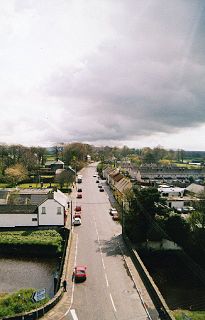
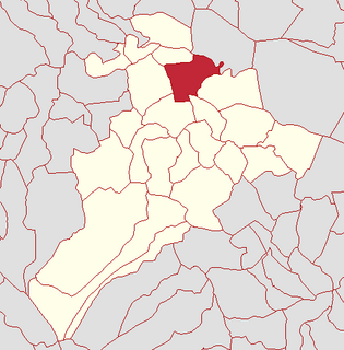
Claudy is a village and townland in County Londonderry, Northern Ireland. It lies in the Faughan Valley, 6 miles (9.7 km) southeast of Derry, where the River Glenrandal joins the River Faughan. It is situated in the civil parish of Cumber Upper and the historic barony of Tirkeeran. It is also part of Derry and Strabane district.
Dervock is a small village and townland in County Antrim, Northern Ireland. It is about 3.5 miles (6 km) northeast of Ballymoney, on the banks of the Dervock River. It is situated in the civil parish of Derrykeighan and the historic barony of Dunluce Lower. It had a population of 714 people in the 2011 Census.
Ballyrashane is a small village and civil parish outside Coleraine, County Londonderry, Northern Ireland. The civil parish of Ballyrashane covers areas of County Antrim, as well as County Londonderry. It is part of Causeway Coast and Glens district.

Tamlaght is a townland and village in County Fermanagh, Northern Ireland, 4.5 km south-east of Enniskillen. It is situated in the civil parish of Derryvullan and the historic barony of Tirkennedy. In the 2001 Census it had a population of 276 people.
Carrowclare is a small village and townland in County Londonderry, Northern Ireland. In the 2001 Census it had a population of 129 people. It is situated within Causeway Coast and Glens district.
Tamlaght is a small village, townland and civil parish in County Londonderry, Northern Ireland. In the 2001 Census it had a population of 123 people. It is situated within Mid-Ulster District. The civil parish of Tamlaght covers areas of County Tyrone as well as County Londonderry.

Clady is a small village and townland in County Tyrone, Northern Ireland. It lies about 4 miles from Strabane on the River Finn and borders with the Republic of Ireland. In the 2001 Census it had a population of 423 people. It is within Urney civil parish and the former barony of Strabane Lower. In local government it is part of the Derry City and Strabane District Council. The townland covers an area of 173 acres.
Tobermore is a townland lying within the civil parish of Kilcronaghan, County Londonderry, Northern Ireland. It lies in the north-east of the parish, and is bounded by the townlands of; Ballynahone Beg, Calmore, Clooney, Drumballyhagan Clark, Moneyshanere, and Moyesset. It was apportioned to the Drapers company as well as freeholds.

Killytoney is a townland lying within the civil parish of Kilcronaghan, County Londonderry, Northern Ireland. It lies in the center of the parish, and is bounded by the townlands of Calmore, Cloughfin, Coolsaragh, Gortamney, Killynumber, and Moyesset. It was apportioned to the Drapers company.

Lisbunny is a townland of 849 acres in County Londonderry, Northern Ireland, about 3 miles Claudy, near the County Tyrone/Londonderry border. It is situated within Derry and Strabane district as well as the civil parish of Cumber Upper and the historic barony of Tirkeeran.
Cumber Upper is a civil parish in County Londonderry, Northern Ireland. It is mainly situated in the historic barony of Tirkeeran, with one townland (Stranagalwilly) in the barony of Strabane Lower.
Ballyrory is a small village and townland in County Londonderry, Northern Ireland. It is situated in the civil parish of Cumber Upper and the historic barony of Tirkeeran.

Altaghoney is townland of 1,163 acres in County Londonderry, Northern Ireland. It is situated in the civil parish of Cumber Upper and the historic barony of Tirkeeran.
Bovevagh is a civil parish in County Londonderry, Northern Ireland.
Broighter is a townland in west County Londonderry, Northern Ireland. It lies 4.4 miles (7 km) northwest of Limavady and 2.5 miles (4 km) northeast of Ballykelly. Broighter is part of Causeway Coast and Glens district.