Greenway, Arkansas

Last updated

Greenway, Arkansas
Greenway-welcome-sign-ar.jpg
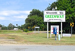
Welcome sign in Greenway
Clay County Arkansas Incorporated and Unincorporated areas Greenway Highlighted 0528720.svg
Location of Greenway in Clay County, Arkansas.
Coordinates: 36°20′26″N90°13′20″W / 36.34056°N 90.22222°W / 36.34056; -90.22222
Country United States
State Arkansas
County Clay
Area
[1]
  Total0.26 sq mi (0.67 km2)
  Land0.26 sq mi (0.67 km2)
  Water0.00 sq mi (0.00 km2)
Elevation
[2]
285 ft (87 m)
Population
 (2020)
  Total174
  Density669.23/sq mi (258.24/km2)
Time zone UTC-6 (Central (CST))
  Summer (DST) UTC-5 (CDT)
ZIP code
72430
Area code 870
FIPS code 05-28720
GNIS feature ID2403754 [2]

Greenway is a city [3] in eastern Clay County, Arkansas, United States. The population was 209 at the 2010 census.

Contents

History

In 1876, W.V. Turner, a physician, established a post office known as "Clayville" (sometimes called "Hamburg") in what is now Greenway. The name was changed to "Greenway" when a railroad line (eventually part of the St. Louis Southwestern system) was constructed through the community and a depot was built. The origin of the name "Greenway" is uncertain. [4]

Geography

Greenway is situated at the eastern base of Crowley's Ridge, a few miles west of the Arkansas-Missouri state line. U.S. Route 49 connects Greenway with Piggott to the northeast and Rector to the southwest.

According to the United States Census Bureau, the town has a total area of 0.5 km2 (0.2 mi2), all land.

Demographics

Historical population
CensusPop.Note
1890 33
1900 165400.0%
1910 390136.4%
1920 362−7.2%
1930 3671.4%
1940 303−17.4%
1950 288−5.0%
1960 179−37.8%
1970 24034.1%
1980 31732.1%
1990 212−33.1%
2000 24415.1%
2010 209−14.3%
2020 174−16.7%
U.S. Decennial Census [5]

At the 2000 census, [6] there were 244 people, 104 households and 66 families residing in the town. The population density was 471.0/km2 (1,191.9/mi2). There were 123 housing units at an average density of 237.5/km2 (600.8/mi2). The racial makeup of the town was 99.18% White, and 0.82% from two or more races.

There were 104 households, of which 25.0% had children under the age of 18 living with them, 57.7% were married couples living together, 3.8% had a female householder with no husband present, and 35.6% were non-families. 33.7% of all households were made up of individuals, and 11.5% had someone living alone who was 65 years of age or older. The average household size was 2.35 and the average family size was 3.00.

24.2% of the population were under the age of 18, 7.4% from 18 to 24, 27.5% from 25 to 44, 26.6% from 45 to 64, and 14.3% who were 65 years of age or older. The median age was 38 years. For every 100 females, there were 114.0 males. For every 100 females age 18 and over, there were 107.9 males.

The median household income was $25,682 and the median family income was $27,500. Males had a median income of $21,591 versus $12,386 for females. The per capita income for the town was $11,533. About 11.1% of families and 16.4% of the population were below the poverty line, including 21.9% of those under the age of eighteen and 15.2% of those 65 or over.

Education

Greenway is served by the Rector School District (formerly the Clay County Central School District). It was served by the Greenway School District until July 1, 1984, when it merged into the Clay County Central school district. [7]

Related Research Articles

<span class="mw-page-title-main">Clay County, Arkansas</span> County in Arkansas, United States

Clay County is a county located in the U.S. state of Arkansas. Originally incorporated as Clayton County, as of the 2020 census, its population was 14,552. The county has two county seats, Corning and Piggott. It is a dry county, in which the sale of alcoholic beverages is restricted or prohibited.

<span class="mw-page-title-main">Big Flat, Arkansas</span> Town in Arkansas, United States

Big Flat is a town in Baxter and Searcy counties in the U.S. state of Arkansas. The population was 88 at the 2020 census.

<span class="mw-page-title-main">Briarcliff, Arkansas</span> City in Arkansas, United States

Briarcliff is a second-class city in Baxter County, Arkansas, United States. The population was 236 at the 2010 census.

<span class="mw-page-title-main">Everton, Arkansas</span> Town in Arkansas, United States

Everton is a town in Boone County, Arkansas, United States. The population was 133 at the 2010 census. It is part of the Harrison Micropolitan Statistical Area.

<span class="mw-page-title-main">South Lead Hill, Arkansas</span> Town in Arkansas, United States

South Lead Hill is a town in Boone County, Arkansas, United States. The population was 102 at the 2010 census. It is part of the Harrison Micropolitan Statistical Area.

<span class="mw-page-title-main">Valley Springs, Arkansas</span> Town in Arkansas, United States

Valley Springs is a town in Boone County, Arkansas, United States. The population was 175 at the 2010 census. It is part of the Harrison Micropolitan Statistical Area.

<span class="mw-page-title-main">Knobel, Arkansas</span> City in Arkansas, United States

Knobel (/ˈnoʊbəl/) is a city in Clay County, Arkansas, United States. The population was 147 at the 2020 census.

<span class="mw-page-title-main">McDougal, Arkansas</span> City in Arkansas, United States

McDougal is a city in Clay County, Arkansas, United States. The population was 186 at the 2010 census.

<span class="mw-page-title-main">Nimmons, Arkansas</span> Town in Arkansas, United States

Nimmons is a town in Clay County, Arkansas, United States. The population was 69 at the 2010 census, down from 100 in 2000.

<span class="mw-page-title-main">Pollard, Arkansas</span> City in Arkansas, United States

Pollard is a city in Clay County, Arkansas, United States. The population was 222 at the 2010 census.

<span class="mw-page-title-main">Rector, Arkansas</span> City in Arkansas, United States

Rector is a city in southeastern Clay County, Arkansas, United States. The population was 1,977 at the 2010 census.

<span class="mw-page-title-main">Success, Arkansas</span> Town in Arkansas, United States

Success is a town in Clay County, Arkansas, United States. The population was 149 at the 2010 census.

<span class="mw-page-title-main">Campbell Station, Arkansas</span> City in Arkansas, United States

Campbell Station is a city in Jackson County, Arkansas, United States. The population was 255 at the 2010 census.

<span class="mw-page-title-main">Grubbs, Arkansas</span> City in Arkansas, United States

Grubbs is a city in Jackson County, Arkansas, United States. The population was 386 at the 2010 census.

<span class="mw-page-title-main">Tupelo, Arkansas</span> Town in Arkansas, United States

Tupelo is a town in Jackson County, Arkansas, United States. The population was 180 at the 2010 census.

<span class="mw-page-title-main">Cale, Arkansas</span> Town in Arkansas, United States

Cale is a town in Nevada County, Arkansas, United States. The population was 75 at the 2000 census. It is part of the Hope Micropolitan Statistical Area.

<span class="mw-page-title-main">Rosston, Arkansas</span> Town in Arkansas, United States

Rosston is a town in south-central Nevada County, Arkansas, United States. The population was 265 at the 2000 census. It is part of the Hope Micropolitan Statistical Area.

<span class="mw-page-title-main">Traskwood, Arkansas</span> City in Arkansas, United States

Traskwood is a city in Saline County, Arkansas, United States. The population was 518 at the 2010 census. It is part of the Little Rock–North Little Rock–Conway Metropolitan Statistical Area.

<span class="mw-page-title-main">Caldwell, Arkansas</span> Town in Arkansas, United States

Caldwell is a town in St. Francis County, Arkansas, United States. The population was 555 at the 2010 census, an increase from 465 in 2000.

<span class="mw-page-title-main">Corinth, Arkansas</span> Town in Arkansas, United States

Corinth is a town in Yell County, Arkansas, United States. The population was 65 at the 2000 census. It is part of the Russellville Micropolitan Statistical Area.

References

  1. "2020 U.S. Gazetteer Files". United States Census Bureau. Retrieved October 29, 2021.
  2. 1 2 U.S. Geological Survey Geographic Names Information System: Greenway, Arkansas
  3. Local.Arkansas.gov - Greenway , retrieved September 3, 2012
  4. Steven Teske, "Greenway (Clay County)," Encyclopedia of Arkansas History and Culture, 2016.
  5. "Census of Population and Housing". Census.gov. Retrieved June 4, 2015.
  6. "U.S. Census website". United States Census Bureau . Retrieved January 31, 2008.
  7. "ConsolidationAnnex_from_1983.xls Archived 2015-09-12 at the Wayback Machine ." Arkansas Department of Education. Retrieved on July 31, 2017.