
The Trent–Severn Waterway is a 386-kilometre-long (240 mi) canal route connecting Lake Ontario at Trenton to Georgian Bay, Lake Huron, at Port Severn. Its major natural waterways include the Trent River, Otonabee River, Kawartha Lakes, Lake Simcoe, Lake Couchiching and Severn River. Its scenic, meandering route has been called "one of the finest interconnected systems of navigation in the world".

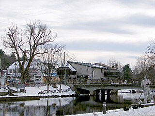
Coboconk, often shortened to Coby, is a community in the city of Kawartha Lakes, in the south-central portion of the Canadian province of Ontario. The village lies at the junction of Highway 35 and former Highway 48, on the northern tip of Balsam Lake, the highest point on the Trent–Severn Waterway. Coboconk has a prominent role in the logging, limestone, and tourism industries of the Kawartha Lakes region over the past 150 years.

The City of Kawartha Lakes is a unitary municipality in Central Ontario, Canada. It is a municipality legally structured as a single-tier city; however, Kawartha Lakes is the size of a typical Ontario county and is mostly rural. It is the second largest single-tier municipality in Ontario by land area.

Haliburton is a county of Ontario, Canada, known as a tourist and cottage area in Central Ontario for its scenery and for its resident artists. Minden Hills is the county seat. Haliburton County and the village of Haliburton are named after Thomas Chandler Haliburton, author, statesman, and the first chairman of the Canadian Land and Emigration Company.

The York River is a river in Renfrew County, Hastings County and Haliburton County in Ontario, Canada. The river is in the Saint Lawrence River drainage basin, and flows from the southern extension of Algonquin Provincial Park to the Madawaska River.

Central Ontario is a secondary region of Southern Ontario in the Canadian province of Ontario that lies between Georgian Bay and the eastern end of Lake Ontario.
Minden Hills is a township in and the county seat of Haliburton County, Ontario, Canada. It is an amalgam of the townships of Snowdon, Lutterworth, Anson, Hindon and Minden. It is usually referred to as Minden, after its largest community.
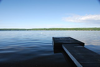
Balsam Lake is a lake in the City of Kawartha Lakes in Central Ontario, Canada. It is in the Great Lakes Basin, is one of the lakes of the Kawartha Lakes, and is at the summit of the Trent–Severn Waterway.
King's Highway 35, commonly referred to as Highway 35, is a provincially maintained highway in the Canadian province of Ontario, linking Highway 401 with the Kawartha Lakes, Haliburton, and Algonquin Provincial Park. The highway travels from west of Newcastle, through Lindsay, near Fenelon Falls, Coboconk, Minden Hills, and into Haliburton before terminating at Highway 60 to the west of Algonquin Park. Within those areas, it services the communities of Orono, Cameron, Rosedale, Norland, Moore Falls, Miners Bay, Lutterworth, Carnarvon, Buttermilk Falls, Halls Lake, Pine Springs and Dorset. The winding course of the road, combined with the picturesque views offered along its length, have led some to declare it the most scenic highway in Ontario.
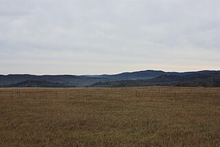
The Opeongo Hills are a range of hills in Southern Ontario, near Algonquin Provincial Park. The hills stretch from Opeongo Lake in Algonquin Park in the west, along the Madawaska and Opeongo Rivers, towards the Opeongo Colonization Road, and extending towards the Deacon Escarpment, Bonnechere, Ontario, and Dacre in the east. To the east of the Opeongo Hills lie the Madawaska River valley, the Mississippi River Valley, and the Ottawa-Bonnechere Graben along the Ottawa River. Its tallest peak is roughly 7 km northeast of Highway 60. At roughly 586 meters, it is the tallest point in Southern Ontario. The community of Foymount is one of the highest settlements in Southern Ontario.
Balsam Lake Provincial Park is a provincial park located in south-central Ontario, Canada, on Balsam Lake. The park is situated along the Trent-Severn Waterway, a few kilometres southwest of Coboconk. It is an all-seasons recreation area offering camping, boating and fishing, and while closed in winter it is also used for skiing and snowshoeing.

Head Lake is a lake in the village of Haliburton, in Haliburton County, Ontario, Canada. Haliburton Village is in south central Ontario, about 25 km (15 mi) east of the village of Minden and approximately 50 km (31 mi) south-west of the panhandle of Algonquin Park. From Ontario's largest city, Toronto, it is just over 200 km (124 mi) to Haliburton, and from the national capital of Ottawa, it is about 300 km (186 mi).
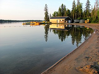
Boshkung Lake, also known by its historic name Lake Boshkung, or affectionately as 'Big Boshkung', is a lake in the township of Algonquin Highlands, Haliburton County in Central Ontario, Canada. It is located near Buttermilk Falls and has been a common cottage and recreation destination with a rich history that includes: logging, camping, and even some farming activities.
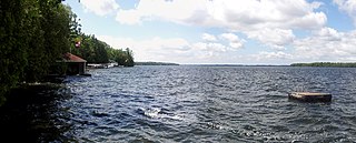
Redstone Lake is a lake located in geographic Guilford Township in the Municipality of Dysart et al, Haliburton County in Central Ontario, Canada. It is in the Great Lakes Basin and is part of the Gull River system. At its longest, it is approximately 6.5km.
Mitchell Lake is a small, artificial lake in the Great Lakes Basin and located in the city of Kawartha Lakes in Central Ontario, Canada. The lake was formed sometime in the first decade of the twentieth century alongside the construction of the Kirkfield Lift Lock, which was completed and operational by the end of 1907. It is part of the summit of the Trent–Severn Waterway, the middle of a connection via canals of Balsam Lake on the Gull River system, which flows eventually to Lake Ontario, and the Kirkfield Lift Lock and Canal Lake on the Talbot River system, which flows to Lake Simcoe and eventually to Lake Huron.
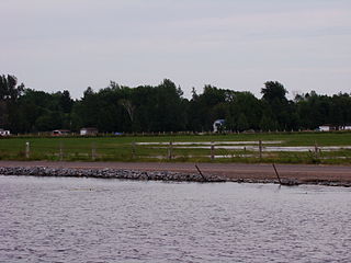
Silver Lake is a small lake in the city of Kawartha Lakes in Central Ontario, Canada. Located near the community of Coboconk, it is the lowest lake on the Gull River, a drainage basin that supplies water at its mouth to Balsam Lake at the top of the Trent-Severn Waterway. Like many other lakes in the Kawarthas, Silver Lake lies in a depression formed between the Precambrian granite to the north, and the Ordovician limestone to the south.
King's Highway 121, commonly referred to as Highway 121, was a provincially maintained highway in the Canadian province of Ontario that connected several communities in the cottage country region of Central Ontario on the southern edge of the Canadian Shield. Between Fenelon Falls and Minden, Highway 121 served as an alternative route to Highway 35, which was severely congested during summer weekends. From Minden, the highway branched east to Haliburton Village and thereafter followed the present route of Highway 118 to Highway 28 in Paudash.
The Redstone River is a river in the municipality of Dysart et al, Haliburton County in central Ontario, Canada that flows from southern Algonquin Provincial Park to the Gull River.
North River may refer to one of five rivers in Ontario, Canada:
The Irondale River is a river in Haliburton County in Central Ontario, Canada. It is part of the Great Lakes Basin, and is a left tributary of the Burnt River.


