Hancock's Bridge, New Jersey

Last updated

Hancock's Bridge, New Jersey
Hancock Bridge Meeting.JPG
Census Bureau map of ZCTA 08038 Hancock's Bridge, New Jersey.gif
United States Census Bureau map of ZCTA 08038 Hancock's Bridge, New Jersey
Location map of Salem County, New Jersey.svg
Red pog.svg
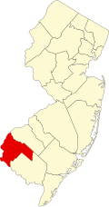
Hancock's Bridge
Location in Salem County
USA New Jersey relief location map.svg
Red pog.svg
Hancock's Bridge
Location in New Jersey
Usa edcp relief location map.png
Red pog.svg
Hancock's Bridge
Location in the United States
Coordinates: 39°30′20″N75°27′44″W / 39.50562°N 75.462261°W / 39.50562; -75.462261 [1] [2]
Country Flag of the United States.svg  United States
State Flag of New Jersey.svg  New Jersey
County Salem
Township Lower Alloways Creek
Area
[3]
  Total0.25 sq mi (0.64 km2)
  Land0.23 sq mi (0.59 km2)
  Water0.02 sq mi (0.05 km2)  3.22%
Elevation
[4]
3 ft (1 m)
Population
 (2020) [5]
  Total155
  Density679.82/sq mi (262.69/km2)
Time zone UTC−05:00 (Eastern (EST))
  Summer (DST) UTC−04:00 (Eastern (EDT))
ZIP Code
08038 [6]
Area code 856
FIPS code 34-29520 [7] [8]
GNIS feature ID02583999 [9]

Hancock's Bridge (also Hancocks Bridge, without an apostrophe) is an unincorporated community and census-designated place (CDP) [10] located within Lower Alloways Creek Township, in Salem County, in the U.S. state of New Jersey. [11] [12] [13] [14] [15] As of the 2010 United States Census, the CDP's population was 254. [16] The area is served as United States Postal Service ZIP Code 08038.

Contents

Geography

According to the United States Census Bureau, Hancocks Bridge had a total area of 0.213 square miles (0.551 km2), including 0.206 square miles (0.533 km2) of land and 0.007 square miles (0.018 km2) of water (3.22%). [1] [2]

Demographics

Historical population
CensusPop.Note
2010 254
2020 155−39.0%
U.S. Decennial Census [17]
2010 [16] 2020 [5]

2010 census

The 2010 United States census counted 254 people, 93 households, and 65 families in the CDP. The population density was 1,234.2 per square mile (476.5/km2). There were 103 housing units at an average density of 500.5 per square mile (193.2/km2). The racial makeup was 97.24% (247) White, 1.57% (4) Black or African American, 0.00% (0) Native American, 1.18% (3) Asian, 0.00% (0) Pacific Islander, 0.00% (0) from other races, and 0.00% (0) from two or more races. Hispanic or Latino of any race were 0.79% (2) of the population. [16]

Of the 93 households, 35.5% had children under the age of 18; 51.6% were married couples living together; 14.0% had a female householder with no husband present and 30.1% were non-families. Of all households, 25.8% were made up of individuals and 14.0% had someone living alone who was 65 years of age or older. The average household size was 2.73 and the average family size was 3.32. [16]

26.8% of the population were under the age of 18, 10.2% from 18 to 24, 25.6% from 25 to 44, 23.2% from 45 to 64, and 14.2% who were 65 years of age or older. The median age was 39.0 years. For every 100 females, the population had 101.6 males. For every 100 females ages 18 and older there were 93.8 males. [16]

Historic sites

The Hancock House is a historic structure that was the site of the 1778 Hancock's Bridge massacre. Built in 1734 for Judge William and Sarah Hancock, the house featured a blue glazed brick pattern, which gave the year of construction, 1734, and the initials of the couple for whom it was built, 'W S' for William and Sarah. William died in 1762, and passed the house to his son William, also a judge. [18]

Related Research Articles

<span class="mw-page-title-main">Concordia, New Jersey</span> Populated place in Middlesex County, New Jersey, US

Concordia is an unincorporated community and census-designated place (CDP) located within Monroe Township, in Middlesex County, in the U.S. state of New Jersey. The CDP is oriented around the age restricted gated community of Concordia. As of the 2010 United States Census, the CDP's population was 3,092.

<span class="mw-page-title-main">Old Bridge (CDP), New Jersey</span> Census-designated place in New Jersey, United States

Old Bridge is a census-designated place (CDP) in Old Bridge Township, in Middlesex County, in the U.S. state of New Jersey. As of the 2010 United States Census, the CDP's population was 23,753. Despite the similarity in the name of the CDP and the township, the two are not one and the same, as had been the case for most paired Township / CDP combinations prior to the 2010 Census, in which the CDP was coextensive with a township of the same name.

<span class="mw-page-title-main">East Freehold, New Jersey</span> Populated place in Monmouth County, New Jersey, US

East Freehold is an unincorporated community and census-designated place (CDP) located within Freehold Township, in Monmouth County, in the U.S. state of New Jersey. As of the 2010 United States Census, the CDP's population was 4,894.

<span class="mw-page-title-main">Cedar Glen Lakes, New Jersey</span> Populated place in Ocean County, New Jersey, US

Cedar Glen Lakes is an unincorporated community and census-designated place (CDP) located within Manchester Township, in Ocean County, in the U.S. state of New Jersey. As of the 2010 United States Census, the CDP's population was 1,421.

<span class="mw-page-title-main">Leisure Village, New Jersey</span> Populated place in Ocean County, New Jersey, US

Leisure Village is an unincorporated community and census-designated place (CDP) located within Lakewood Township, in Ocean County, in the U.S. state of New Jersey. As of the 2010 United States Census, the CDP's population was 4,400. The sprawling active adult community is also locally known as "Original" Leisure Village because it was the first of three neighboring active adult communities bearing similar names. Leisure Village East, and Leisure Village West are the other two communities nearby. Original Leisure Village (OLV) is also referred to by the moniker "The Village of Seven Lakes."

<span class="mw-page-title-main">Crandon Lakes, New Jersey</span> Populated place in Sussex County, New Jersey, US

Crandon Lakes is an unincorporated community and census-designated place (CDP) split between Hampton Township and Stillwater Township, in Sussex County, in the U.S. state of New Jersey. As of the 2010 United States Census, the CDP's population was 1,178, of which 682 were in Hampton Township and 496 in Stillwater Township.

<span class="mw-page-title-main">Buttzville, New Jersey</span> Populated place in Warren County, New Jersey, US

Buttzville is an unincorporated community and census-designated place (CDP) located within White Township in Warren County, in the U.S. state of New Jersey, that was created as part of the 2010 United States Census. As of the 2010 Census, the CDP's population was 146.

<span class="mw-page-title-main">Yardville, New Jersey</span> Populated place in Camden County, New Jersey, US

Yardville is an unincorporated community and census-designated place (CDP) located within Hamilton Township, in Mercer County, in the U.S. state of New Jersey. As of the 2010 United States Census, the CDP's population was 2,945. Before the 2010 Census, the area was part of the Yardville-Groveville CDP.

Clyde is an unincorporated community and census-designated place (CDP) located in Franklin Township, in Somerset County, in the U.S. state of New Jersey. It was a station stop on the Penna RR's Millstone Branch. As of the 2010 United States Census, the CDP's population was 213.

<span class="mw-page-title-main">Allamuchy (CDP), New Jersey</span> Populated place in Warren County, New Jersey, US

Allamuchy is an unincorporated community and census-designated place (CDP) located within Allamuchy Township, in Warren County, in the U.S. state of New Jersey. As of the 2020 United States census, its population was 208, an increase from the 74 counted in the 2010 census.

Blairstown is an unincorporated community and census-designated place (CDP) located within Blairstown Township, in Warren County, in the U.S. state of New Jersey. The CDP was created as part of the 2010 United States census. As of the 2010 United States census, the CDP's population was 515.

<span class="mw-page-title-main">Brainards, New Jersey</span> Census-designated place in New Jersey, United States

Brainards is an unincorporated community and census-designated place (CDP) located within Harmony Township, in Warren County, in the U.S. state of New Jersey, that was created as part of the 2010 United States Census. As of the 2010 United States Census, the CDP's population was 202. It was formerly known as Martin's Creek.

Bridgeville is an unincorporated community and census-designated place (CDP) located within White Township, in Warren County, in the U.S. state of New Jersey, that was created as part of the 2010 United States Census. As of the 2010 Census, the CDP's population was 106.

Broadway is an unincorporated community and census-designated place (CDP) located within Franklin Township, in Warren County, in the U.S. state of New Jersey, that was created as part of the 2010 United States Census. As of the 2010 Census, the CDP's population was 244.

Ross Corner is an unincorporated community and census-designated place (CDP) located in Frankford Township, in Sussex County, in the U.S. state of New Jersey. As of the 2010 United States Census, the CDP's population was 13.

Upper Stewartsville is an unincorporated community and census-designated place (CDP) located within Greenwich Township in Warren County, in the U.S. state of New Jersey, that was defined as part of the 2010 United States Census. As of the 2010 Census, the CDP's population was 212.

Harmony is an unincorporated community and census-designated place (CDP) located within Harmony Township in Warren County, in the U.S. state of New Jersey, that was defined as part of the 2010 United States Census. As of the 2010 Census, the CDP's population was 441.

Hutchinson is an unincorporated community and census-designated place (CDP) located within Harmony Township in Warren County, in the U.S. state of New Jersey, that was defined as part of the 2010 United States Census. As of the 2010 Census, the CDP's population was 135.

<span class="mw-page-title-main">Hope (CDP), New Jersey</span> Populated place in Warren County, New Jersey, US

Hope is an unincorporated community and census-designated place (CDP) located within Hope Township in Warren County, in the U.S. state of New Jersey, that was defined as part of the 2010 United States Census. As of the 2010 Census, the CDP's population was 195.

Mount Hermon is an unincorporated community and census-designated place (CDP) located within Hope Township in Warren County, in the U.S. state of New Jersey, that was defined as part of the 2010 United States Census. As of the 2010 Census, the CDP's population was 141.

References

  1. 1 2 Gazetteer of New Jersey Places, United States Census Bureau. Accessed July 21, 2016.
  2. 1 2 US Gazetteer files: 2010, 2000, and 1990, United States Census Bureau. Accessed September 4, 2014.
  3. "ArcGIS REST Services Directory". United States Census Bureau. Retrieved October 11, 2022.
  4. U.S. Geological Survey Geographic Names Information System: Hancocks Bridge Census Designated Place, Geographic Names Information System. Accessed February 9, 2013.
  5. 1 2 Census Data Explorer: Hancocks Bridge CDP, New Jersey, United States Census Bureau. Accessed June 15, 2023.
  6. Look Up a ZIP Code for Hancocks Bridge, NJ, United States Postal Service. Accessed February 9, 2013.
  7. U.S. Census website, United States Census Bureau. Accessed September 4, 2014.
  8. Geographic Codes Lookup for New Jersey, Missouri Census Data Center. Accessed June 9, 2023.
  9. US Board on Geographic Names, United States Geological Survey. Accessed September 4, 2014.
  10. State of New Jersey Census Designated Places - BVP20 - Data as of January 1, 2020, United States Census Bureau. Accessed December 1, 2022.
  11. Gordon, Thomas Francis (1834). "A Gazetteer of the State of New Jersey: Comprehending a General View of Its Physical and Moral Condition, Together with a Topographical and Statistical Account of Its Counties, Towns, Villages, Canals, Rail Roads, &c., Accompanied by a Map".
  12. GCT-PH1 - Population, Housing Units, Area, and Density: 2010 - County -- County Subdivision and Place from the 2010 Census Summary File 1 for Salem County, New Jersey Archived 2020-02-12 at archive.today , United States Census Bureau. Accessed February 9, 2013.
  13. 2006-2010 American Community Survey Geography for New Jersey, United States Census Bureau. Accessed February 9, 2013.
  14. New Jersey: 2010 - Population and Housing Unit Counts - 2010 Census of Population and Housing (CPH-2-32), United States Census Bureau, August 2012. Accessed February 9, 2013.
  15. Locality Search, State of New Jersey. Accessed April 18, 2015.
  16. 1 2 3 4 5 DP-1 - Profile of General Population and Housing Characteristics: 2010 Demographic Profile Data for Hancocks Bridge CDP, New Jersey Archived 2020-02-12 at archive.today , United States Census Bureau. Accessed February 9, 2013.
  17. "Census of Population and Housing". Census.gov. Retrieved June 4, 2016.
  18. Hancock House, New Jersey Department of Environmental Protection. Accessed December 25, 2008.