Related Research Articles

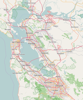
Richmond is a city in western Contra Costa County, California, United States. The city was incorporated on August 7, 1905 and has a city council. Located in the East Bay region of the San Francisco Bay Area, Richmond borders the cities of San Pablo, Albany, El Cerrito and Pinole in addition to the unincorporated communities of North Richmond, Hasford Heights, Kensington, El Sobrante, Bayview-Montalvin Manor, Tara Hills, and East Richmond Heights, and for a short distance San Francisco on Red Rock Island in the San Francisco Bay. Richmond is one of two cities, the other being San Rafael, California, that sits on the shores of San Francisco Bay and San Pablo Bay simultaneously.

Contra Costa County is a county in the state of California in the United States. As of the 2010 census, the population was 1,049,025. The county seat is Martinez. It occupies the northern portion of the East Bay region of the San Francisco Bay Area, and is primarily suburban. The county's name is Spanish for "opposite coast", referring to its position on the other side of the bay from San Francisco. Contra Costa County is included in the San Francisco–Oakland–Berkeley, CA Metropolitan Statistical Area.

El Cerrito is a city in Contra Costa County, California, United States, and forms part of the San Francisco Bay Area. It has a population of 23,549 according to the 2010 census. El Cerrito was founded by refugees from the 1906 San Francisco earthquake. It was incorporated in 1917 as a village with 1,500 residents. As of the census in 2000, there were 23,171 people, 10,208 households and 5,971 families in the city.

The San Fernando Valley is an urbanized valley in Los Angeles County, California, in the Los Angeles metropolitan area, defined by the mountains of the Transverse Ranges circling it. Home to 1.77 million people, it is north of the larger, more populous Los Angeles Basin.

Pacific Palisades is a largely residential neighborhood in the Westside of the city of Los Angeles, California, located among Brentwood to the east, Malibu and Topanga to the west, Santa Monica to the southeast, the Santa Monica Bay to the southwest, and the Santa Monica Mountains to the north. It is about 9 miles northwest of the UCLA campus. Known by locals as "The Palisades" this area of L.A. is known for low crime and high profile residents including several celebrities.

Granada Hills is a lightly populated, highly diverse and high-income neighborhood. It is a suburban residential community in the San Fernando Valley portion of the city of Los Angeles, California.
South Shore is one of 77 defined community areas of Chicago, Illinois, United States. A predominantly African-American neighborhood on the city's South Side, the area is named for its location along the city's southern lakefront. Although South Shore has seen a greater than 40% decrease in residents since Chicago's population peaked in the 1950s, the area remains one of the most densely populated neighborhoods on the South Side. The community benefits from its location along the waterfront, its accessibility to Lake Shore Drive, and its proximity to major institutions and attractions such as the University of Chicago, the Museum of Science and Industry, and Jackson Park.

Porter Ranch is a neighborhood in the northwest region of the San Fernando Valley region of the city of Los Angeles, California.

City Heights is a large community in central San Diego, California, known for its ethnic diversity. The area was previously known as East San Diego. City Heights is located south of Mission Valley and northeast of Balboa Park.

Normal Heights is a neighborhood of the mid-city region of San Diego, California.
The Iron Triangle, sometimes known as Central Richmond, is a neighborhood in Richmond, California. It is a largely residential area but includes the downtown Richmond business district along Macdonald Avenue. Commercial areas on Cutting Boulevard and near Interstate 580 are also in the neighborhood if the more extensive of two possible definitions of its area is used.

Wildcat Canyon Regional Park is a 2,429-acre (983 ha) East Bay Regional Parks District park located within the city limits of Richmond in Contra Costa County in the San Francisco Bay Area of California. It includes a portion of Wildcat Canyon as well as a portion of the adjoining San Pablo Ridge, and is directly connected to the more heavily used Tilden Regional Park.
Alvarado Park is a subsection of Wildcat Canyon Regional Park in Richmond, California and is a National Historic Place. It is located at the mouth of Wildcat Canyon in the Alvarado Park section. Between 1909 and 1923, Alvarado Park was a private park that was owned and operated by local residents. In 1923, it was donated to the city of Richmond. Later it was admitted into the East Bay Regional Park District.

Grantville is a middle-class neighborhood in the city of San Diego, in California. It borders the communities of Allied Gardens, San Carlos, Tierrasanta and Mission Valley East.

Wildcat Creek is a 13.4-mile-long (21.6 km) creek which flows through Wildcat Canyon situated between the Berkeley Hills and the San Pablo Ridge, emptying into San Pablo Bay in Contra Costa County, northern California.
Anaheim Hills is a planned community encompassing the eastern portions of the city of Anaheim, in Orange County, California.

The Eastshore and Suburban Railway (E&SR) was a formerly independent unit of the historic San Francisco Bay Area Key System which ran streetcar trains in Richmond, California, San Pablo, and El Cerrito. There were several lines with terminals at Point Richmond, North Richmond, the county line with Alameda County, what is now San Pablo, and Grand Canyon/East Richmond/Alvarado Park. Service to Oakland required a transfer to Oakland Traction Company trains at the County Line station and service to San Francisco required an additional transfer in Oakland. The systems were later consolidated into the Key System. Service began to be replaced by buses beginning on August 1, 1932, with the conversion of the East Richmond/23rd Street line to buses. Lines were converted to buses one at a time with the last remaining line being in September 1933. Fares were originally 5 cents and were raised to 7 cents over time at the time of the last runs.

The Point Richmond Historic District is the downtown area of Point Richmond in Richmond, California, and is on the National Register of Historic Places.
Blue Ridge is a community in Houston, Texas, United States that used to be a distinct unincorporated area in northeast Fort Bend County. The community, which was also known as Hobby, is located on a ridge of Oyster Creek, 16 miles (26 km) east of Richmond. The section of Blue Ridge within the Houston City Limits is known as the Fort Bend-Houston Super Neighborhood #41.

Tahoe Park is a neighborhood located within the city of Sacramento, California.
References
- ↑ "Senators". State of California. Retrieved April 1, 2013.
- ↑ "Members Assembly". State of California. Retrieved April 1, 2013.
- ↑ "California's 11th Congressional District - Representatives & District Map". Civic Impulse, LLC. Retrieved March 9, 2013.
- ↑ "Richmond Neighborhood Coordinating Council and Neighborhood Councils". City of Richmond, California. Retrieved 22 July 2020.
- ↑ "Chronology of the East Shore and Suburban Railway" (PDF). El Cerrito Historical Society. Archived from the original (PDF) on 2007-09-27. Retrieved 2007-09-07.

| This Contra Costa County, California–related article is a stub. You can help Wikipedia by expanding it. |