
Bay County is a county on the Emerald Coast in Northwest Florida. As of the 2020 census, the population was 175,216. Its county seat is Panama City. Bay County is included in the Panama City, Florida metropolitan area.

Interstate 4 (I-4) is an Interstate Highway located entirely within the US state of Florida, maintained by the Florida Department of Transportation (FDOT). Spanning 132.30 miles (212.92 km) along a generally southwest–northeast axis, I-4 is entirely concurrent with State Road 400 (SR 400). In the west, I-4 begins at an interchange with I-275 in Tampa. I-4 intersects with several major expressways as it traverses Central Florida, including US Highway 41 (US 41) in Tampa; US 301 near Riverview; I-75 near Brandon; US 98 in Lakeland; US 27 in unincorporated Davenport; US 192 in Celebration; Florida's Turnpike in Orlando; and US 17 and US 92 in multiple junctions. In the east, I-4 ends at an interchange with I-95 in Daytona Beach, while SR 400 continues for roughly another four miles (6.4 km) and ends at an intersection with US 1 on the city line of Daytona Beach and South Daytona.

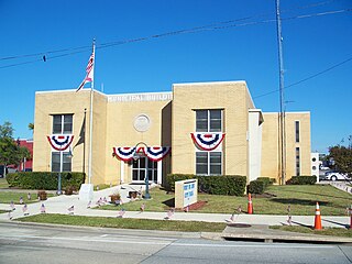
Panama City is a city in and the county seat of Bay County, Florida, United States. Located along U.S. Highway 98 (US 98), it is the largest city between Tallahassee and Pensacola. It is also the most populated city and a principal city of the Panama City–Panama City Beach, Florida Metropolitan Statistical Area with around 200,534 in the metropolitan area. As of the 2020 census, the city population was 32,939, down from the figure of 36,484 at the 2010 census.

Panama City Beach is a resort town in the Florida Panhandle, and principal city of the Panama City Metropolitan Area. It is a popular vacation destination, especially among people in the Southern United States, and is located in the "Emerald Coast" area. Panama City Beach had a population of 18,094 at the 2020 census, up from 12,018 in 2010. Panama City Beach's slogan is "The World's Most Beautiful Beaches" due to the unique, sugar-white sandy beaches of the Florida Panhandle.
Port St. Joe is a city and the county seat of Gulf County, Florida. It is located at the intersection of U.S. Highway 98 and State Road 71. As of the 2020 census, the population was 3,357.

U.S. Route 90 or U.S. Highway 90 (US 90) is an east–west major United States highway in the Southern United States. Despite the "0" in its route number, US 90 never was a full coast-to-coast route. It generally travels near Interstate 10 (I-10) and passes through the southern states of Texas, Louisiana, Mississippi, Alabama, and Florida. US 90 also includes part of the DeSoto Trail between Tallahassee and Lake City, Florida.

U.S. Route 98 is an east–west United States Highway in the Southeastern United States that runs from western Mississippi to southern Florida. It was established in 1933 as a route between Pensacola and Apalachicola, Florida, and has since been extended westward into Mississippi and eastward across the Florida Peninsula. It runs along much of the Gulf Coast between Mobile, Alabama, and Crystal River, Florida, including extensive sections closely following the coast between Mobile and St. Marks, Florida. The highway's western terminus is with US 84 in Bude, Mississippi. Its eastern terminus is Palm Beach, Florida, at State Road A1A (SR A1A) near the Mar-a-Lago resort.

The Florida panhandle is the northwestern part of the U.S. state of Florida. It is a salient roughly 200 miles (320 km) long, bordered by Alabama on the north and the west, Georgia on the north, and the Gulf of Mexico to the south. Its eastern boundary is arbitrarily defined. It is defined by its southern culture and rural geography relative to the rest of Florida, as well as closer cultural links to French-influenced Louisiana, Mississippi, and Alabama. Its major communities include Pensacola, Navarre, Destin, Panama City Beach, and Tallahassee.

State Road 30A (SR 30A) is a Florida Department of Transportation designation shared by four alternate routings of SR 30 in the Florida panhandle. Two segments have SR 30A signage; the other two do not as they are segments of U.S. Route 98 (US 98). Three of the four SR 30A segments are next to the shore of the Gulf of Mexico for most of their length.

State Road 30 is the mostly hidden Florida Department of Transportation designation for most of US 98 from the Florida-Alabama state line to east of Perry, Florida.

John Clark was an American planter, politician, and slaveholder. He was the 31st Governor of the U.S. state of Georgia, from 1819 to 1823. As governor, he prevailed in the U.S. Supreme Court case Ex parte Madrazzo, a dispute over whether a claim of ownership of a group of enslaved people could be enforced against the state. He also advocated for presidential electors to be elected by popular vote as seen in many of his bills, culminating to the 1824 Georgia Popular Vote Referendum.

Governor Stone is an historic schooner, built in 1877 in Pascagoula, Mississippi, United States. She is the only surviving two-masted coasting cargo schooner built on the Gulf Coast of the United States, and is only one of five such surviving US-built ships. On 4 December 1991, she was added to the US National Register of Historic Places. One year later, the schooner was designated a US National Historic Landmark. She is presently berthed at Saint Andrews Marina in Panama City, Florida, where she is maintained by a nonprofit group. Sailing tours are regularly scheduled.

State Road 77 is a major north–south artery in Florida's Panhandle, connecting Panama City to the south with Alabama State Route 109 and Dothan, Alabama to the north.
U.S. Route 98 is a major east-west thoroughfare through the U.S. state of Florida. Spanning 670.959 miles (1,079.804 km), it connects Pensacola and the Alabama/Florida state line to the west with Palm Beach and the Atlantic coast in the east. It is the longest US road in Florida, as well as the longest US road in any state east of the Mississippi River.

State Road 390 is a two-lane state highway in Bay County, Florida. The route is signed as east-west but runs more north-south for much of its run. The western (southern) terminus is at the intersection of U.S. Route 98 (US 98)/SR 30 and US 98 BUS/SR 30A in St. Andrews. The highway is carried by Beck Ave from this point until shortly after it crosses SR 368, at which point it becomes St Andrews Blvd. The route winds northeasterly into Lynn Haven, where it is carried by Tennessee Ave at one point. In Lynn Haven, the road eventually turns due east and intersects with SR 77, and continues east until its terminus at US 231/SR 75. The portion between SR 77 and US 231 was signed as SR S-390 before being given to the county in the late 1970s, and back to the state in 2016.
The News Herald is a daily newspaper serving the city of Panama City, Florida in the United States. It is located at 501 W. 11th St. in Panama City.
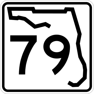
State Road 79 is a north–south highway in the panhandle of Florida. It is a popular route for tourists to and from the Panama City Beach area. The route begins at Alabama State Route 167 at the Alabama–Florida border and runs to its southern terminus at US 98 in Panama City Beach, Florida. Currently, the highway is being expanded to four lanes north of Panama City to the junction with Interstate 10. SR 79 is a major hurricane evacuation route from the coastal area. It is one of few designated routes northward between Pensacola and Panama City.
North Florida is a region of the U.S. state of Florida comprising the northernmost part of the state. Along with South Florida and Central Florida, it is one of Florida's three most common "directional" regions. It includes Jacksonville and nearby localities in Northeast Florida, an interior region known as North Central Florida, and the Florida Panhandle. North Florida is considered to be part of the Southern United States, namely the Deep South, and contains the state capital of Tallahassee.
There are six special routes along U.S. Route 98 and seven former routes. Most US 98 bannered routes are located in the U.S. state of Florida.
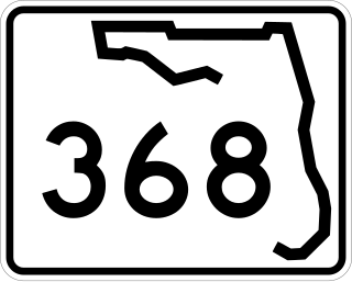
State Road 368 (SR 368) is a short state road an east–west "bypass route", locally known as 23rd Street, in and around the vicinity of Panama City, Florida. The road is entirely four-lanes wide with center left-turn lanes where available, and is divided only at its eastern terminus. No roads overlap SR 368 or vice versa.

