Haviland, Ohio

Last updated

Haviland, Ohio
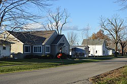
McKinley from Maple, Haviland.jpg
Houses on McKinley Street
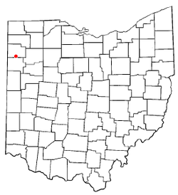
OHMap-doton-Haviland.png
Location of Haviland, Ohio
Map of Paulding County Ohio Highlighting Haviland Village.png
Location of Haviland in Paulding County
Coordinates: 41°1′10″N84°34′52″W / 41.01944°N 84.58111°W / 41.01944; -84.58111
Country United States
State Ohio
County Paulding
Township Blue Creek
Government
  MayorRichard C. Bowers
Area
[1]
  Total0.39 sq mi (1.02 km2)
  Land0.39 sq mi (1.02 km2)
  Water0.00 sq mi (0.00 km2)
Elevation
[2]
735 ft (224 m)
Population
 (2020)
  Total160
  Density407.12/sq mi (157.10/km2)
Time zone UTC-5 (Eastern (EST))
  Summer (DST) UTC-4 (EDT)
ZIP code
45851
Area code 419
FIPS code 39-34552 [3]
GNIS feature ID1041402 [2]

Haviland is a village in Paulding County, Ohio, United States. The population was 160 at the 2020 census.

Contents

Geography

Haviland is located at 41°01′10″N84°34′52″W / 41.019387°N 84.581068°W / 41.019387; -84.581068 . [4]

According to the United States Census Bureau, the village has a total area of 0.39 square miles (1.01 km2), all land. [5]

Demographics

Historical population
CensusPop.Note
1900 186
1910 23325.3%
1920 27015.9%
1930 202−25.2%
1940 2104.0%
1950 23511.9%
1960 2350.0%
1970 231−1.7%
1980 219−5.2%
1990 210−4.1%
2000 180−14.3%
2010 21519.4%
2020 160−25.6%
U.S. Decennial Census [6]

2010 census

As of the census [7] of 2010, there were 215 people, 79 households, and 57 families living in the village. The population density was 551.3 inhabitants per square mile (212.9/km2). There were 88 housing units at an average density of 225.6 per square mile (87.1/km2). The racial makeup of the village was 96.3% White, 0.5% African American, 2.3% from other races, and 0.9% from two or more races. Hispanic or Latino of any race were 5.6% of the population.

There were 79 households, of which 32.9% had children under the age of 18 living with them, 54.4% were married couples living together, 10.1% had a female householder with no husband present, 7.6% had a male householder with no wife present, and 27.8% were non-families. 19.0% of all households were made up of individuals, and 10.1% had someone living alone who was 65 years of age or older. The average household size was 2.72 and the average family size was 3.02.

The median age in the village was 34.9 years. 26.5% of residents were under the age of 18; 10.3% were between the ages of 18 and 24; 27.4% were from 25 to 44; 22.8% were from 45 to 64; and 13% were 65 years of age or older. The gender makeup of the village was 47.9% male and 52.1% female.

2000 census

As of the census [3] of 2000, there were 180 people, 68 households, and 48 families living in the village. The population density was 626.6 inhabitants per square mile (241.9/km2). There were 79 housing units at an average density of 275.0 per square mile (106.2/km2). The racial makeup of the village was 97.78% White, 0.56% African American, 0.56% Native American, 0.56% from other races, and 0.56% from two or more races. Hispanic or Latino of any race were 1.11% of the population.

There were 68 households, out of which 26.5% had children under the age of 18 living with them, 60.3% were married couples living together, 4.4% had a female householder with no husband present, and 29.4% were non-families. 23.5% of all households were made up of individuals, and 10.3% had someone living alone who was 65 years of age or older. The average household size was 2.65 and the average family size was 3.17.

In the village, the population was spread out, with 25.6% under the age of 18, 13.3% from 18 to 24, 24.4% from 25 to 44, 23.3% from 45 to 64, and 13.3% who were 65 years of age or older. The median age was 34 years. For every 100 females there were 102.2 males. For every 100 females age 18 and over, there were 103.0 males.

The median income for a household in the village was $31,607, and the median income for a family was $31,250. Males had a median income of $29,583 versus $26,563 for females. The per capita income for the village was $14,029. About 10.0% of families and 13.1% of the population were below the poverty line, including 14.3% of those under the age of eighteen and none of those 65 or over.
Related Research Articles

<span class="mw-page-title-main">Haviland, Kansas</span> City in Kiowa County, Kansas

Haviland is a city in Kiowa County, Kansas, United States. As of the 2020 census, the population of the city was 678. It is home of Barclay College and known for meteorite finds connected to the Haviland Crater and for an annual meteorite festival held in July.

<span class="mw-page-title-main">Sunfield, Michigan</span> Village in Michigan, United States

Sunfield is a village in Eaton County in the U.S. state of Michigan. The population was 578 at the 2010 census. The village is located within Sunfield Township.

<span class="mw-page-title-main">Ashley, Michigan</span> Village in Michigan, United States

Ashley is a village in Gratiot County in the U.S. state of Michigan. The population was 508 at the 2020 census. The village is located in the northwest corner of Elba Township. No major state trunkline runs through the village, although M-57 passes within one mile to the south. Ashley was platted in 1884.

<span class="mw-page-title-main">Mattawan, Michigan</span> Village in Michigan, United States

Mattawan is a village in Antwerp Township, Van Buren County of the U.S. state of Michigan. The population was 1,997 at the 2010 census.

<span class="mw-page-title-main">Fountain N' Lakes, Missouri</span> Village in Missouri, United States

Fountain N' Lakes is a village in Lincoln County, Missouri, United States. The population was 165 at the 2010 census.

<span class="mw-page-title-main">Hanley Hills, Missouri</span> Village in Missouri, United States

Hanley Hills is a village in St. Louis County, Missouri, United States. The population was 2,101 at the 2010 census.

<span class="mw-page-title-main">Haviland, New York</span> Census-designated place in New York, United States

Haviland is a community and census-designated place (CDP) in Dutchess County, New York, United States. The population was 3,634 at the 2010 census. It is part of the Poughkeepsie–Newburgh–Middletown, NY Metropolitan Statistical Area as well as the larger New York–Newark–Bridgeport, NY-NJ-CT-PA Combined Statistical Area.

<span class="mw-page-title-main">Waynesfield, Ohio</span> Village in Ohio, United States

Waynesfield is a village in Auglaize County, Ohio, United States. The population was 749 at the 2020 census. It is included in the Wapakoneta, Ohio Micropolitan Statistical Area.

<span class="mw-page-title-main">Clarksville, Ohio</span> Village in Ohio, United States

Clarksville is a village in Clinton County, Ohio, United States. The population was 534 at the 2020 census. It is served by the Clinton Massie branch of the Wilmington Public Library of Clinton County.

<span class="mw-page-title-main">Addyston, Ohio</span> Village in Ohio, United States

Addyston is a village in Miami Township, Hamilton County, Ohio, United States, along the Ohio River. The population was 927 at the 2020 census.

<span class="mw-page-title-main">West Salem, Ohio</span> Village in Ohio, United States

West Salem is a village in Wayne County, Ohio. The population was 1,430 at the time of the 2020 census. West Salem is served by a branch of the Wayne County Public Library.

<span class="mw-page-title-main">Hilbert, Wisconsin</span> Village in Wisconsin, United States

Hilbert is a village in Calumet County in the U.S. state of Wisconsin. The population was 1,132 at the 2010 census.

<span class="mw-page-title-main">Blue River, Wisconsin</span> Village in Wisconsin, United States

Blue River is a village in Grant County, Wisconsin, United States. The population was 434 at the 2010 census.

<span class="mw-page-title-main">Coleman, Wisconsin</span> Village in Wisconsin, United States

Coleman is a village in Marinette County, Wisconsin, United States. The population was 726 at the 2020 census. It is part of the Marinette, WI–MI Micropolitan Statistical Area.

<span class="mw-page-title-main">Exeland, Wisconsin</span> Village in Wisconsin, United States

Exeland is a village in Sawyer County, Wisconsin, United States. The population was 229 at the 2020 census.

<span class="mw-page-title-main">Cecil, Wisconsin</span> Village in Wisconsin, United States

Cecil is a village in Shawano County, Wisconsin, United States. The population was 570 at the 2010 census.

<span class="mw-page-title-main">Yorkville, Ohio</span> Village in Ohio, United States

Yorkville is a village in Belmont and Jefferson counties in the U.S. state of Ohio. The population was 968 at the 2020 census. Yorkville lies within two Metropolitan Statistical Areas; the Belmont County portion is part of the Wheeling metropolitan area, while the Jefferson County portion is part of the Weirton–Steubenville metropolitan area.

<span class="mw-page-title-main">Bloomington, Wisconsin</span> Village in Wisconsin, United States

Bloomington is a village in Grant County, Wisconsin, United States. The population was 735 as of the 2010 census. The village is located within the Town of Bloomington.

<span class="mw-page-title-main">Necedah, Wisconsin</span> Village in Wisconsin, United States

Necedah is a village in Juneau County, Wisconsin, United States. The population was 916 at the 2010 census. The village is located within the Town of Necedah.

<span class="mw-page-title-main">Hammond, Wisconsin</span> Village in Wisconsin, United States

Hammond is a village in St. Croix County, Wisconsin, United States. The population was 1,922 at the 2010 census. The village is located within the Town of Hammond. Hammond was home to the Running of the Llamas.

References

  1. "ArcGIS REST Services Directory". United States Census Bureau. Retrieved September 20, 2022.
  2. 1 2 "US Board on Geographic Names". United States Geological Survey. October 25, 2007. Retrieved January 31, 2008.
  3. 1 2 "U.S. Census website". United States Census Bureau . Retrieved January 31, 2008.
  4. "US Gazetteer files: 2010, 2000, and 1990". United States Census Bureau. February 12, 2011. Retrieved April 23, 2011.
  5. "US Gazetteer files 2010". United States Census Bureau . Retrieved January 6, 2013.
  6. "Census of Population and Housing". Census.gov. Retrieved June 4, 2015.
  7. "U.S. Census website". United States Census Bureau . Retrieved January 6, 2013.