Scott, Ohio

Last updated

Scott, Ohio
Blaine near Grand in Scott.jpg
Blaine Street, downtown. Paulding County is to the left, and Van Wert County to the right.
OHMap-doton-Scott.png
Location of Scott, Ohio
Map of Van Wert County Ohio Highlighting Scott Village.png
Location of Scott in Van Wert County
Coordinates: 40°59′22″N84°35′3″W / 40.98944°N 84.58417°W / 40.98944; -84.58417
Country United States
State Ohio
Counties Van Wert, Paulding
Government
  MayorBryon A. Glass
Area
[1]
  Total0.81 sq mi (2.10 km2)
  Land0.81 sq mi (2.10 km2)
  Water0.00 sq mi (0.00 km2)
Elevation
[2]
735 ft (224 m)
Population
 (2020)
  Total242
  Density298.40/sq mi (115.24/km2)
Time zone UTC-5 (Eastern (EST))
  Summer (DST) UTC-4 (EDT)
ZIP code
45886
Area code 419
FIPS code 39-71080 [3]
GNIS feature ID1046050 [2]

Scott is a village in Paulding and Van Wert counties in the U.S. state of Ohio. The population was 242 at the 2020 census. The Van Wert County portion of Scott is part of the Van Wert Micropolitan Statistical Area.

Contents

History

Scott was platted in 1882 by J. T. Scott, and named for him. [4] A post office called Scott has been in operation since 1882. [5]

Geography

Scott is located at 40°59′22″N84°35′3″W / 40.98944°N 84.58417°W / 40.98944; -84.58417 (40.989467, -84.584067). [6]

According to the United States Census Bureau, the village has a total area of 0.81 square miles (2.10 km2), all land. [7]

Demographics

Historical population
CensusPop.Note
1890 733
1900 547−25.4%
1910 472−13.7%
1920 342−27.5%
1930 3533.2%
1940 3591.7%
1950 347−3.3%
1960 3655.2%
1970 329−9.9%
1980 3403.3%
1990 339−0.3%
2000 322−5.0%
2010 286−11.2%
2020 242−15.4%
U.S. Decennial Census [8]

2010 census

As of the census [9] of 2010, there were 286 people, 111 households, and 76 families living in the village. The population density was 353.1 inhabitants per square mile (136.3/km2). There were 126 housing units at an average density of 155.6 per square mile (60.1/km2). The racial makeup of the village was 98.6% White, 0.7% from other races, and 0.7% from two or more races. Hispanic or Latino of any race were 0.7% of the population.

There were 111 households, of which 38.7% had children under the age of 18 living with them, 55.0% were married couples living together, 7.2% had a female householder with no husband present, 6.3% had a male householder with no wife present, and 31.5% were non-families. 27.9% of all households were made up of individuals, and 14.4% had someone living alone who was 65 years of age or older. The average household size was 2.58 and the average family size was 3.18.

The median age in the village was 34.7 years. 28.3% of residents were under the age of 18; 8.7% were between the ages of 18 and 24; 25.1% were from 25 to 44; 24.7% were from 45 to 64; and 12.9% were 65 years of age or older. The gender makeup of the village was 47.6% male and 52.4% female.

2000 census

As of the census [3] of 2000, there were 322 people, 121 households, and 87 families living in the village. The population density was 399.1 inhabitants per square mile (154.1/km2). There were 130 housing units at an average density of 161.1 per square mile (62.2/km2). The racial makeup of the village was 95.96% White, 2.80% African American, 0.31% Native American, 0.93% from other races. Hispanic or Latino of any race were 1.86% of the population.

There were 121 households, out of which 38.0% had children under the age of 18 living with them, 63.6% were married couples living together, 5.8% had a female householder with no husband present, and 27.3% were non-families. 23.1% of all households were made up of individuals, and 9.9% had someone living alone who was 65 years of age or older. The average household size was 2.66 and the average family size was 3.14.

In the village, the population was spread out, with 29.5% under the age of 18, 11.8% from 18 to 24, 26.4% from 25 to 44, 21.1% from 45 to 64, and 11.2% who were 65 years of age or older. The median age was 32 years. For every 100 females there were 100.0 males. For every 100 females age 18 and over, there were 104.5 males.

The median income for a household in the village was $36,667, and the median income for a family was $41,667. Males had a median income of $31,563 versus $21,875 for females. The per capita income for the village was $14,192. About 8.0% of families and 13.3% of the population were below the poverty line, including 22.0% of those under age 18 and 8.8% of those age 65 or over.

Related Research Articles

<span class="mw-page-title-main">Van Wert County, Ohio</span> County in Ohio, United States

Van Wert County is a county located in the U.S. state of Ohio. As of the 2020 census, the population was 28,931. Its county seat is Van Wert. The county was created on February 12, 1820, and later organized on March 18, 1837. It is named for Isaac Van Wart, one of the captors of John André in the American Revolutionary War.

<span class="mw-page-title-main">Arizona Village, Arizona</span> Census-designated place in Arizona, United States

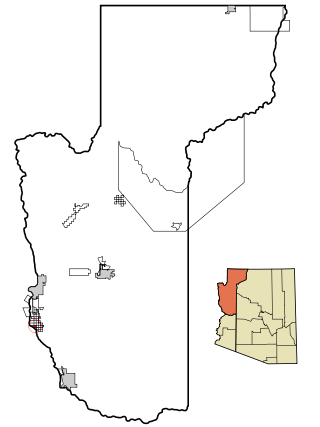
Arizona Village is a census-designated place (CDP) on the Fort Mojave Indian Reservation in Mohave County, Arizona, United States. The population was 1,057 at the 2020 census, up from 946 in 2010 and 351 in 2000.

<span class="mw-page-title-main">Mango, Florida</span> Census-designated place in Florida, United States

Mango is a census-designated place (CDP) in Hillsborough County, Florida, United States. The population was 11,313 at the 2010 census, up from 8,842 at the 2000 census.

<span class="mw-page-title-main">Van Wert, Iowa</span> City in Iowa, United States

Van Wert is a city in northern Decatur County, Iowa, United States. The population was 178 at the time of the 2020 census.

<span class="mw-page-title-main">Lambert, Missouri</span> Inactive Village in Missouri, United States

Lambert is an inactive village in Scott County, Missouri, United States. The population was 48 at the 2020 census.

<span class="mw-page-title-main">Convoy, Ohio</span> Village in Ohio, United States

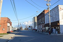
Convoy is a village in Van Wert County, Ohio, United States. The population was 1,085 at the 2010 census. It is included in the Van Wert, Ohio Micropolitan Statistical Area.

<span class="mw-page-title-main">Elgin, Ohio</span> Village in Ohio, United States

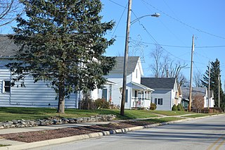
Elgin is a village in Van Wert County, Ohio, United States. The population was 57 at the 2010 census. It is included within the Van Wert, Ohio Micropolitan Statistical Area.

<span class="mw-page-title-main">Middle Point, Ohio</span> Village in Ohio, United States

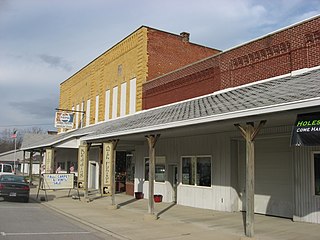
Middle Point is a village in Van Wert County, Ohio, United States. The population was 576 at the 2010 census. It is included within the Van Wert, Ohio Micropolitan Statistical Area.

<span class="mw-page-title-main">Ohio City, Ohio</span> Village in Ohio, United States

Ohio City is a village in Liberty Township, Van Wert County, Ohio, United States. The population was 705 at the 2010 census. It is included within the Van Wert, Ohio Micropolitan Statistical Area.

<span class="mw-page-title-main">Van Wert, Ohio</span> City in Ohio, United States

Van Wert is a city in and the county seat of Van Wert County, Ohio, United States. It is located in northwestern Ohio approximately 77 miles (124 km) southwest of Toledo and 34 miles (55 km) southeast of Fort Wayne, Indiana. The population was 11,092 at the 2020 census. It is the principal city of the Van Wert micropolitan area, which is included in the Lima–Van Wert–Wapakoneta combined statistical area.

<span class="mw-page-title-main">Venedocia, Ohio</span> Village in Ohio, United States

Venedocia is a village in Van Wert County, Ohio, United States. The population was 124 at the 2010 census. It is included within the Van Wert, Ohio Micropolitan Statistical Area and the Lima-Van Wert-Wapakoneta, OH Combined Statistical Area.

<span class="mw-page-title-main">Willshire, Ohio</span> Village in Ohio, United States

Willshire is a village in Van Wert County, Ohio, United States. The population was 397 at the 2010 census. It is included within the Van Wert, Ohio Micropolitan Statistical Area.

<span class="mw-page-title-main">Wren, Ohio</span> Village in Ohio, United States

Wren is a village in Van Wert County, Ohio, United States. The population was 194 at the 2010 census. It is included within the Van Wert, Ohio Micropolitan Statistical Area.

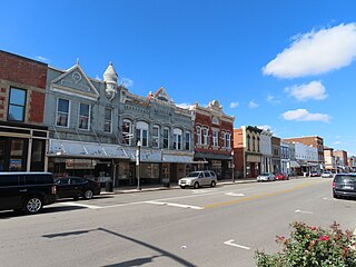
Campbelltown is an unincorporated community and census-designated place (CDP) in Lebanon County, Pennsylvania, United States. The population was 3,616 at the 2010 census. It is located east of Hershey at the intersection of U.S. Route 322 and Pennsylvania Route 117 and is located in the Harrisburg metropolitan area.

<span class="mw-page-title-main">Yale, South Dakota</span> Town in South Dakota, United States

Yale is an incorporated town in Beadle County, South Dakota, United States. The population was 112 at the 2020 census.

<span class="mw-page-title-main">Santa Clara, Texas</span> City in Texas, United States

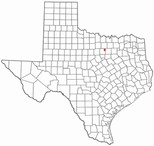
Santa Clara is a city in Guadalupe County, Texas, United States. The population was 725 at the 2010 census, down from 889 at the 2000 census. It is part of the San Antonio Metropolitan Statistical Area.

<span class="mw-page-title-main">Sanctuary, Texas</span> Town in Texas, United States

Sanctuary is a town in Parker County, Texas, United States. The population was 329 at the 2010 census, and was incorporated in the early 1980s.

<span class="mw-page-title-main">Cana, Virginia</span> CDP in Virginia, United States

Cana is a census-designated place (CDP) in Carroll County, Virginia, United States. The population was 1,254 at the 2010 census, up from 1,228 in 2000. It is the only CDP designated area in the county that is outside of the Appalachian Mountains in the Virginia Piedmont.

McCormack is an unorganized territory in Saint Louis County, Minnesota, United States, located near Hibbing and Balkan Township. The population was 237 at the 2000 census.

<span class="mw-page-title-main">Delphos, Ohio</span> City in Ohio, United States

Delphos is a city in Allen and Van Wert counties in the U.S. state of Ohio approximately 14 mi (23 km) northwest of Lima and 13 mi (21 km) east of Van Wert. The population was 7,117 at the 2020 census.

References

  1. "ArcGIS REST Services Directory". United States Census Bureau. Retrieved September 20, 2022.
  2. 1 2 "US Board on Geographic Names". United States Geological Survey. October 25, 2007. Retrieved January 31, 2008.
  3. 1 2 "U.S. Census website". United States Census Bureau . Retrieved January 31, 2008.
  4. Overman, William Daniel (1958). Ohio Town Names. Akron, OH: Atlantic Press. p. 124.
  5. "Van Wert County". Jim Forte Postal History. Retrieved December 13, 2015.
  6. "US Gazetteer files: 2010, 2000, and 1990". United States Census Bureau. February 12, 2011. Retrieved April 23, 2011.
  7. "US Gazetteer files 2010". United States Census Bureau. Archived from the original on July 2, 2012. Retrieved January 6, 2013.
  8. "Census of Population and Housing". Census.gov. Retrieved June 4, 2015.
  9. "U.S. Census website". United States Census Bureau . Retrieved January 6, 2013.