Headland, Alabama

Last updated

Headland
Headland, Alabama.JPG
This statue of a World War I doughboy, with his arm outstretched, honors all of Headland's military dead. It stands at the center of Headland Public Square.
Henry County Alabama Incorporated and Unincorporated areas Headland Highlighted 0133856.svg
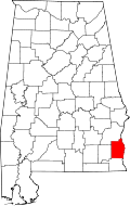
Location of Headland in Henry County, Alabama.
Coordinates: 31°21′12″N85°20′23″W / 31.35333°N 85.33972°W / 31.35333; -85.33972
CountryUnited States
State Alabama
County Henry
Government
   Mayor Ray Marler (R), 2009–present [1]
Area
[2]
  Total30.34 sq mi (78.58 km2)
  Land30.33 sq mi (78.56 km2)
  Water0.01 sq mi (0.03 km2)
Elevation
385 ft (117 m)
Population
 (2020)
  Total4,973
  Density163.96/sq mi (63.31/km2)
Time zone UTC−6 (Central (CST))
  Summer (DST) UTC−5 (CDT)
ZIP code
36345
Area code 334
FIPS code 01-33856
GNIS feature ID0119910
Website www.headlandalabama.org

Headland is the largest city in Henry County, Alabama, United States. It is part of the Dothan metropolitan area. In 2020, the population was 4,973, up from 4,510 [3] in the 2010 census. Ray Marler is the current mayor.

Contents

History

James Joshua Head (1839–1927) founded Headland in 1871 as "Head's Land". He patented land, plotted the town and built his home there. The Headland post office opened on October 10, 1871.

The Headland Public Square was laid off in 1871 by Head with a vision for a branch courthouse. Henry County voters decided in the 1879 and 1885 courthouse site elections not to locate a courthouse on the public square. Henry has been Alabama's only county with three courthouses at the same time.

Head sold Headland to Hosey C. Powell in 1879, who sold to Dr. Wyatt S. Oates in 1880. Head moved to Tampa, Florida, in 1883 and later established Lake Magdalene, Florida.

Headland incorporated in 1884 with 26 white and 4 Black petitioners. The railroad was built in 1893 along with the Seaboard Coast Line Railroad Depot. The depot was added to the National Register of Historic Places on September 4, 1980. It has since been disassembled.

Headland's The Spirit of the American Doughboy statue was the first public statue in Henry County. It was erected on the square in 1926 as a tribute to the town's military dead. The square was paved in 1935.

As of the 1960 U.S. census, Headland had grown into Henry County's largest city, narrowly edging out Abbeville, which had been the largest since Dothan was removed into Houston County in 1903. Headland lost that distinction to Abbeville again in 1970, but regained it in 1980 and has since solidified its hold. In 2000, it broke Dothan's then-Henry County 1900 record of 3,275 residents with 3,523 and added nearly 1,000 more by 2010.

Geography

Headland is located in the southwest corner of Henry County at 31°21′12″N85°20′23″W / 31.35333°N 85.33972°W / 31.35333; -85.33972 (31.353410, -85.339793). [4] It is bordered to the south by the city of Dothan and town of Kinsey in Houston County and to the west by Dale County.

U.S. Route 431, a four-lane highway, passes through the east side of Headland, leading south 10 miles (16 km) to the center of Dothan and north 18 miles (29 km) to Abbeville. Alabama State Route 134 runs through the center of Headland, leading east 16 miles (26 km) to Columbia next to the Georgia line, and west 10 miles (16 km) to Midland City.

According to the U.S. Census Bureau, Headland has a total area of 30.3 square miles (78.5 km2), of which 0.01 square miles (0.03 km2), or 0.03%, are water. [3]

Climate

Climate data for Headland, Alabama, 1991–2020 normals, extremes 19502022
MonthJanFebMarAprMayJunJulAugSepOctNovDecYear
Record high °F (°C)84
(29)
87
(31)
89
(32)
94
(34)
100
(38)
104
(40)
108
(42)
106
(41)
101
(38)
98
(37)
88
(31)
84
(29)
108
(42)
Mean maximum °F (°C)76.0
(24.4)
78.9
(26.1)
84.1
(28.9)
88.2
(31.2)
93.5
(34.2)
97.3
(36.3)
98.0
(36.7)
97.5
(36.4)
94.9
(34.9)
89.3
(31.8)
82.5
(28.1)
77.9
(25.5)
99.1
(37.3)
Mean daily maximum °F (°C)60.5
(15.8)
64.8
(18.2)
72.2
(22.3)
79.0
(26.1)
86.6
(30.3)
91.0
(32.8)
92.8
(33.8)
91.7
(33.2)
88.5
(31.4)
79.9
(26.6)
70.3
(21.3)
62.7
(17.1)
78.3
(25.7)
Daily mean °F (°C)49.4
(9.7)
53.1
(11.7)
59.8
(15.4)
66.2
(19.0)
74.7
(23.7)
80.2
(26.8)
82.2
(27.9)
81.2
(27.3)
77.4
(25.2)
67.9
(19.9)
58.4
(14.7)
51.8
(11.0)
66.9
(19.4)
Mean daily minimum °F (°C)38.2
(3.4)
41.3
(5.2)
47.4
(8.6)
53.5
(11.9)
62.8
(17.1)
69.4
(20.8)
71.6
(22.0)
70.6
(21.4)
66.2
(19.0)
55.9
(13.3)
46.5
(8.1)
40.8
(4.9)
55.4
(13.0)
Mean minimum °F (°C)21.0
(−6.1)
24.8
(−4.0)
29.9
(−1.2)
38.7
(3.7)
48.7
(9.3)
60.9
(16.1)
65.8
(18.8)
63.7
(17.6)
54.3
(12.4)
38.7
(3.7)
28.6
(−1.9)
25.2
(−3.8)
18.4
(−7.6)
Record low °F (°C)0
(−18)
10
(−12)
12
(−11)
27
(−3)
41
(5)
45
(7)
51
(11)
54
(12)
39
(4)
26
(−3)
15
(−9)
5
(−15)
0
(−18)
Average precipitation inches (mm)4.80
(122)
5.15
(131)
4.83
(123)
4.61
(117)
3.65
(93)
5.16
(131)
6.73
(171)
5.07
(129)
4.59
(117)
3.16
(80)
3.87
(98)
5.10
(130)
56.72
(1,442)
Average snowfall inches (cm)0.0
(0.0)
0.1
(0.25)
0.0
(0.0)
0.0
(0.0)
0.0
(0.0)
0.0
(0.0)
0.0
(0.0)
0.0
(0.0)
0.0
(0.0)
0.0
(0.0)
0.0
(0.0)
0.0
(0.0)
0.1
(0.25)
Average precipitation days (≥ 0.01 in)10.59.78.97.47.512.013.612.67.86.27.89.6113.6
Average snowy days (≥ 0.1 in)0.00.10.00.00.00.00.00.00.00.00.00.00.1
Source 1: NOAA [5]
Source 2: National Weather Service [6]

Demographics

Historical population
CensusPop.Note
1900 602
1910 1,09081.1%
1920 1,25214.9%
1930 1,81144.6%
1940 2,05213.3%
1950 2,0911.9%
1960 2,65026.7%
1970 2,545−4.0%
1980 3,32730.7%
1990 3,266−1.8%
2000 3,5237.9%
2010 4,51028.0%
2020 4,97310.3%
U.S. Decennial Census [7]
2013 Estimate [8]

2010 census

As of the census of 2010, [9] there were 4,510 people, 1,799 households, and 1,291 families residing in the city. The population density was 281.9 inhabitants per square mile (108.8/km2). There were 1,949 housing units at an average density of 121.8 per square mile (47.0/km2). The racial makeup of the city was 70.1% White, 27.5% Black or African American, 0.4% Native American, 0.3% Asian, 0.6% from other races, and 1.2% from two or more races. 1.4% of the population were Hispanic or Latino of any race.

There were 1,799 households, out of which 30.1% had children under the age of 18 living with them, 50.1% were married couples living together, 17.7% had a female householder with no husband present, and 28.2% were non-families. 25.3% of all households were made up of individuals, and 12.3% had someone living alone who was 65 years of age or older. The average household size was 2.50 and the average family size was 2.99.

In the city, the age distribution of the population shows 25.6% under the age of 18, 6.7% from 18 to 24, 26.6% from 25 to 44, 27.0% from 45 to 64, and 14.1% who were 65 years of age or older. The median age was 38.3 years. For every 100 females, there were 83.7 males. For every 100 females age 18 and over, there were 82.9 males.

The median income for a household in the city was $45,813, and the median income for a family was $50,120. Males had a median income of $37,025 versus $30,734 for females. The per capita income for the city was $20,304. About 13.6% of families and 12.1% of the population were below the poverty line, including 8.7% of those under age 18 and 20.7% of those age 65 or over.

2020 census

Headland racial composition [10]
RaceNum.Perc.
White (non-Hispanic)3,54171.2%
Black or African American (non-Hispanic)1,16823.49%
Native American 60.12%
Asian 240.48%
Other/Mixed 1763.54%
Hispanic or Latino 581.17%

As of the 2020 United States census, there were 4,973 people, 1,583 households, and 1,131 families residing in the city.

Education

Headland is a part of the Henry County Public Schools system. It operates Headland Elementary School (K-5), Headland Middle School (6-9) and Headland High School (10-12). [11]

Sports

Headland was home to the Headland Dixie Runners, a Minor League Baseball team in the Alabama State League/Alabama–Florida League from 1950 to 1952.

Headland was also the home to the 2016 Dixie Youth Baseball World Champions.

Notable people

Related Research Articles

<span class="mw-page-title-main">Coffee County, Alabama</span> County in Alabama, United States

Coffee County is a county located in the southeastern part of the U.S. state of Alabama. As of the 2020 census, the population was 53,465. Its name is in honor of General John Coffee.

<span class="mw-page-title-main">Dale County, Alabama</span> County in Alabama, United States

Dale County is a county located in the southeastern part of the U.S. state of Alabama. As of the 2020 census the population was 49,326. Its county seat and largest city is Ozark. Its name is in honor of General Samuel Dale.

<span class="mw-page-title-main">Henry County, Alabama</span> County in Alabama, United States

Henry County is a county in the southeastern part of the U.S. state of Alabama. As of the 2020 census, its population was 17,146. Its county seat is Abbeville. The county was named for Patrick Henry (1736–1799), famous orator and Governor of Virginia.

<span class="mw-page-title-main">Houston County, Alabama</span> County in Alabama, United States

Houston County is a county located in the southeastern corner of the U.S. state of Alabama. As of the 2020 census the population was 107,202. Its county seat is Dothan, which is located on the border and partially in adjacent Henry County.

<span class="mw-page-title-main">Grimes, Alabama</span> Town in Alabama, United States

Grimes is a town in Dale County, Alabama, United States. At the 2010 census the population was 558, up from 459 in 2000. It is part of the Enterprise–Ozark Micropolitan Statistical Area.

<span class="mw-page-title-main">Midland City, Alabama</span> Town in Alabama, United States

Midland City is a town in Dale County, Alabama, United States. At the 2010 U.S. Census the population was 2,344. It incorporated in 1890. It is part of the Ozark Micropolitan Statistical Area.

<span class="mw-page-title-main">Ozark, Alabama</span> City in Alabama, United States

Ozark is a city in and the county seat of Dale County, Alabama. As of the 2010 census, the population of the city was 14,907.

<span class="mw-page-title-main">Abbeville, Alabama</span> City in and county seat of Henry County, Alabama

Abbeville is a city in and the county seat of Henry County, in the southeast part of Alabama, United States. It is part of the Dothan, Alabama Metropolitan Statistical Area. At the 2020 census, the population was 2,358.

<span class="mw-page-title-main">Haleburg, Alabama</span> Town in Alabama, United States

Haleburg is a town in Henry County, Alabama, United States. It is part of the Dothan, Alabama Metropolitan Statistical Area. At the 2020 census, the population was 112. Established in 1885 as "Halesburgh", the town was incorporated in September, 1911, as "Halesburg". Since then, for reasons unknown, it has become known as the current "Haleburg".

<span class="mw-page-title-main">Newville, Alabama</span> Town in Alabama, United States

Newville is a town in Henry County, Alabama, United States. It is part of the Dothan, Alabama Metropolitan Statistical Area. At the 2020 census, the population was 544.

<span class="mw-page-title-main">Ashford, Alabama</span> Town in Alabama, United States

Ashford is a town in Houston County, Alabama, United States. It is part of the Dothan, Alabama Metropolitan Statistical Area. The town was incorporated in June 1891. For most of its history, it was a center for naval stores production, pulpwood harvesting, and cotton agriculture. The population was 2,148 at the 2010 census, up from 1,853 at the 2000 census.

<span class="mw-page-title-main">Columbia, Alabama</span> Town in Alabama, United States

Columbia is a town in Houston County, Alabama, United States. It is part of the Dothan, Alabama Metropolitan Statistical Area. At the 2010 census the population was 740, down from 804 in 2000.

<span class="mw-page-title-main">Cowarts, Alabama</span> Town in Alabama, United States

Cowarts is a town in Houston County, Alabama, United States. The town incorporated in August 1961. It is part of the Dothan, Alabama Metropolitan Statistical Area. At the 2010 census the population was 1,871, up from 1,546 in 2000.

<span class="mw-page-title-main">Gordon, Alabama</span> Town in Alabama, United States

Gordon is a town in Houston County, Alabama, United States. It was incorporated in February 1872. It is part of the Dothan, Alabama Metropolitan Statistical Area. At the 2010 census the population was 332, down from 408 in 2000.

<span class="mw-page-title-main">Kinsey, Alabama</span> Town in the United States

Kinsey is a town in Houston County, Alabama, United States. It was initially located and incorporated in Henry County in February 1893. In 1903, it was redrawn into newly created Houston County and was later reincorporated in August 1957. It is part of the Dothan, Alabama Metropolitan Statistical Area. At the 2010 census the population was 2,198, up from 1,796 in 2000.

<span class="mw-page-title-main">Madrid, Alabama</span> Town in Alabama, United States

Madrid is a town in Houston County, Alabama, United States. It is part of the Dothan, Alabama Metropolitan Statistical Area. At the 2010 census the population was 350, up from 303 in 2000.

<span class="mw-page-title-main">Rehobeth, Alabama</span> Town of the State of Alabama in the United States

Rehobeth is a town in Houston County, Alabama, United States. Rehobeth, originally named Sanders, began as a crossroads community in the 1890s; however, it was not until 1996, that the town was incorporated. Rehobeth is part of the Dothan Metropolitan Statistical Area. At the time of the 2010 census, the population was 1,297, up from 993 at the 2000 census.

<span class="mw-page-title-main">Mud Bay, Alaska</span> Census-designated place in Alaska, United States

Mud Bay is a census-designated place (CDP) in Haines Borough, Alaska, United States. At the 2010 census the population was 212, up from 137 at the 2000 census.

<span class="mw-page-title-main">Hatley, Wisconsin</span> Village in Wisconsin, United States

Hatley is a village in Marathon County, Wisconsin, United States. It is part of the Wausau, Wisconsin Metropolitan Statistical Area. The population was 574 at the 2010 census.

Hollins is a census-designated place (CDP) in Botetourt and Roanoke County, Virginia, United States. Hollins covers much of the area known locally as "North County". The population was 15,574 at the 2020 census. It is part of the Roanoke Metropolitan Statistical Area. The area is also the home of Hollins University in addition to four properties listed on the National Register of Historic Places: the Black Horse Tavern-Bellvue Hotel and Office, Harshbarger House, the Hollins College Quadrangle, and Old Tombstone.

References

  1. "Mayor's Office - City of Headland, Alabama - Gem of the Wiregrass". headlandalabama.org. Retrieved January 2, 2020.
  2. "2020 U.S. Gazetteer Files". United States Census Bureau. Retrieved October 29, 2021.
  3. 1 2 "Geographic Identifiers: 2010 Demographic Profile Data (G001): Headland city, Alabama". American Factfinder. U.S. Census Bureau. Retrieved April 12, 2017.[ dead link ]
  4. "US Gazetteer files: 2010, 2000, and 1990". United States Census Bureau. February 12, 2011. Retrieved April 23, 2011.
  5. "U.S. Climate Normals Quick Access – Station: Headland, AL". National Oceanic and Atmospheric Administration. Retrieved March 4, 2023.
  6. "NOAA Online Weather Data – NWS Tallahassee". National Weather Service. Retrieved March 4, 2023.
  7. "U.S. Decennial Census". Census.gov. Retrieved June 6, 2013.
  8. "Annual Estimates of the Resident Population: April 1, 2010 to July 1, 2013". Archived from the original on May 22, 2014. Retrieved June 3, 2014.
  9. "U.S. Census website". United States Census Bureau . Retrieved July 25, 2015.
  10. "Explore Census Data". data.census.gov. Retrieved December 17, 2021.
  11. "Henry County School District". www.henrycountyboe.org. Retrieved May 13, 2019.

31°21′12″N85°20′23″W / 31.35341°N 85.339793°W / 31.35341; -85.339793