Holmesville, Ohio

Last updated

Holmesville, Ohio
Holmesville, Ohio Post Office.jpg
Holmesville Post Office
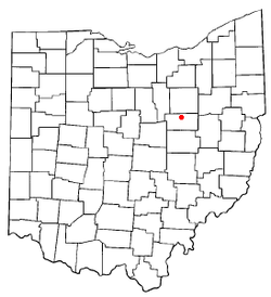
OHMap-doton-Holmesville.png
Location of Holmesville, Ohio
Detailed map of Holmesville, Ohio.png
Detailed map of Holmesville
Coordinates: 40°37′44″N81°55′24″W / 40.62889°N 81.92333°W / 40.62889; -81.92333
Country United States
State Ohio
County Holmes
Township Prairie
Area
[1]
  Total0.23 sq mi (0.60 km2)
  Land0.22 sq mi (0.58 km2)
  Water0.01 sq mi (0.02 km2)
Elevation
[2]
850 ft (260 m)
Population
 (2020)
  Total371
  Density1,663.68/sq mi (643.38/km2)
Time zone UTC-5 (Eastern (EST))
  Summer (DST) UTC-4 (EDT)
ZIP code
44633
Area code 330
FIPS code 39-35994 [3]
GNIS feature ID2398530 [2]

Holmesville is a village in Holmes County, Ohio, United States, along Killbuck Creek. The population was 371 at the 2020 census.

Contents

Holmesville was platted in 1836, and named for its location with Holmes County. [4]

Geography

According to the United States Census Bureau, the village has a total area of 0.24 square miles (0.62 km2), of which 0.23 square miles (0.60 km2) is land and 0.01 square miles (0.03 km2) is water. [5]

Demographics

Historical population
CensusPop.Note
1870 299
1880 34415.1%
1900 304
1910 3205.3%
1920 35912.2%
1930 342−4.7%
1940 3759.6%
1950 3924.5%
1960 4227.7%
1970 412−2.4%
1980 4365.8%
1990 419−3.9%
2000 386−7.9%
2010 372−3.6%
2020 371−0.3%
U.S. Decennial Census [6]

2010 census

As of the census [7] of 2010, there were 372 people, 146 households, and 107 families living in the village. The population density was 1,617.4 inhabitants per square mile (624.5/km2). There were 153 housing units at an average density of 665.2 per square mile (256.8/km2). The racial makeup of the village was 98.7% White, 0.3% Asian, and 1.1% from two or more races. Hispanic or Latino of any race were 0.3% of the population.

There were 146 households, of which 32.2% had children under the age of 18 living with them, 51.4% were married couples living together, 13.7% had a female householder with no husband present, 8.2% had a male householder with no wife present, and 26.7% were non-families. 22.6% of all households were made up of individuals, and 9.5% had someone living alone who was 65 years of age or older. The average household size was 2.55 and the average family size was 2.92.

The median age in the village was 36 years. 23.4% of residents were under the age of 18; 8.8% were between the ages of 18 and 24; 27.1% were from 25 to 44; 28% were from 45 to 64; and 12.6% were 65 years of age or older. The gender makeup of the village was 49.7% male and 50.3% female.

2000 census

As of the census [3] of 2000, there were 386 people, 151 households, and 104 families living in the village. The population density was 1,617.4 inhabitants per square mile (624.5/km2). There were 159 housing units at an average density of 666.2 per square mile (257.2/km2). The racial makeup of the village was 97.93% White, 0.52% Native American, 1.30% from other races, and 0.26% from two or more races. Hispanic or Latino of any race were 2.33% of the population.

There were 151 households, out of which 31.8% had children under the age of 18 living with them, 51.0% were married couples living together, 11.9% had a female householder with no husband present, and 30.5% were non-families. 27.2% of all households were made up of individuals, and 12.6% had someone living alone who was 65 years of age or older. The average household size was 2.56 and the average family size was 3.07.

In the village, the population was spread out, with 24.1% under the age of 18, 9.6% from 18 to 24, 30.1% from 25 to 44, 23.1% from 45 to 64, and 13.2% who were 65 years of age or older. The median age was 38 years. For every 100 females, there were 108.6 males. For every 100 females age 18 and over, there were 96.6 males.

The median income for a household in the village was $37,375, and the median income for a family was $39,375. Males had a median income of $27,396 versus $17,679 for females. The per capita income for the village was $13,314. About 3.8% of families and 6.4% of the population were below the poverty line, including 1.7% of those under age 18 and 18.2% of those age 65 or over.

Related Research Articles

<span class="mw-page-title-main">Piney, Garland County, Arkansas</span> CDP in Arkansas, United States

Piney is a census-designated place (CDP) in Garland County, Arkansas, United States. The population was 4,699 at the 2010 census.

<span class="mw-page-title-main">Quincy Township, Branch County, Michigan</span> Civil township in Michigan, United States

Quincy Township is a civil township of Branch County in the U.S. state of Michigan. The population was 4,108 at the 2020 census.

<span class="mw-page-title-main">Marathon Township, Michigan</span> Civil township in Michigan, United States

Marathon Township is a civil township of Lapeer County in the U.S. state of Michigan. The population was 4,568 at the 2010 Census.

Vassar Township is a civil township of Tuscola County in the U.S. state of Michigan. The population was 4,093 at the 2010 Census. The city of Vassar is located on the western edge of the township, but is administratively autonomous.

Detroit Township is a township in Becker County, Minnesota, United States. The population was 2,033 as of the 2010 census.

Holmesville Township is a township in Becker County, Minnesota, United States. The population was 457 as of the 2000 census.

Richwood Township is a township in Becker County, Minnesota, United States. The population was 610 as of the 2000 census.

Milaca Township is a township in Mille Lacs County, Minnesota, United States. The population was 1,617 at the 2010 census.

<span class="mw-page-title-main">Braymer, Missouri</span> City in Missouri, United States

Braymer is a city in southeast Caldwell County, Missouri. The population was 737 at the 2020 census.

<span class="mw-page-title-main">Cedar Glen Lakes, New Jersey</span> Populated place in Ocean County, New Jersey, US

Cedar Glen Lakes is an unincorporated community and census-designated place (CDP) located within Manchester Township, in Ocean County, in the U.S. state of New Jersey. As of the 2010 United States Census, the CDP's population was 1,421.

<span class="mw-page-title-main">Lockland, Ohio</span> Village in Ohio, United States

Lockland is a village in Hamilton County, Ohio, United States. The population was 3,514 at the 2020 United States Census. Lockland is located in southwest Ohio, north of Cincinnati.

<span class="mw-page-title-main">West Jefferson, Ohio</span> Village in Ohio, United States

West Jefferson is a village in Madison County, Ohio, United States. The population was 4,137 at the 2020 census. Located along U.S. Route 40, the village has a fairly close relationship with the surrounding township, which include various out-of-corporation-limit neighborhoods.

Shiloh is a census-designated place (CDP) in Harrison Township in Montgomery County, Ohio, United States. It was delineated as a census-designated place at the 2000 census, at which time its population was 11,272. It was not delineated as a CDP at the 2010 census. It is located directly north of the city of Dayton and is part of the Dayton Metropolitan Statistical Area.

<span class="mw-page-title-main">Fredericksburg, Ohio</span> Village in Ohio, United States

Fredericksburg is a village in Salt Creek Township, Wayne County, Ohio, United States. The population was 409 at the 2020 census.

<span class="mw-page-title-main">Earl Township, Lancaster County, Pennsylvania</span> Township in Pennsylvania, United States

Earl Township is a township in northeastern Lancaster County, Pennsylvania, United States. The population was 7,149 at the 2020 census.

<span class="mw-page-title-main">Abram-Perezville, Texas</span> Former census-designated place in Texas

Abram-Perezville is a former census-designated place (CDP) in Hidalgo County, Texas. The population was 5,376 at the 2010 United States Census. It is part of the McAllen–Edinburg–Mission Metropolitan Statistical Area. For the 2010 census, the CDP was split into Abram and Perezville.

<span class="mw-page-title-main">Avoca, Wisconsin</span> Village in Wisconsin, United States

Avoca is a village in Iowa County, Wisconsin, United States. The population was 637 at the 2010 census. It is part of the Madison Metropolitan Statistical Area. It is named after Avoca in Ireland.

<span class="mw-page-title-main">Downsville, Louisiana</span> Village in Louisiana, United States

Downsville is a village in Lincoln and Union parishes in the U.S. state of Louisiana. The population as of the 2010 census was 143, an increase from 118 in the 2000 census.

<span class="mw-page-title-main">Wilson, Ohio</span> Village in Ohio, United States

Wilson is a village in Belmont and Monroe counties in the U.S. state of Ohio. The population was 129 at the 2020 census. It is part of the Wheeling metropolitan area.

<span class="mw-page-title-main">Verona, Ohio</span> Village in Ohio, United States

Verona is a village in Montgomery and Preble counties in the U.S. state of Ohio. The population was 403 at the 2020 census. It is part of the Dayton Metropolitan Statistical Area.

References

  1. "ArcGIS REST Services Directory". United States Census Bureau. Retrieved September 20, 2022.
  2. 1 2 U.S. Geological Survey Geographic Names Information System: Holmesville, Ohio
  3. 1 2 "U.S. Census website". United States Census Bureau . Retrieved January 31, 2008.
  4. Overman, William Daniel (1958). Ohio Town Names. Akron, OH: Atlantic Press. p. 62.
  5. "US Gazetteer files 2010". United States Census Bureau. Archived from the original on January 25, 2012. Retrieved January 6, 2013.
  6. "Census of Population and Housing". Census.gov. Retrieved June 4, 2015.
  7. "U.S. Census website". United States Census Bureau . Retrieved January 6, 2013.