
Hurricane Agnes was the costliest hurricane to hit the United States at the time, causing an estimated $2.1 billion in damage. The hurricane's death toll was 128. The effects of Agnes were widespread, from the Caribbean to Canada, with much of the east coast of the United States affected. Damage was heaviest in Pennsylvania, where Agnes was the state's wettest tropical cyclone. Due to the significant effects, the name Agnes was retired in the spring of 1973.

The 1995 Atlantic hurricane season was a very active Atlantic hurricane season, and is considered to be the start of an ongoing era of high-activity tropical cyclone formation. The season produced twenty-one tropical cyclones, nineteen named storms, as well as eleven hurricanes and five major hurricanes. The season officially began on June 1 and ended on November 30, dates which conventionally delimit the period of each year when most tropical cyclones develop in the Atlantic basin. The first tropical cyclone, Hurricane Allison, developed on June 2, while the season's final storm, Hurricane Tanya, transitioned into an extratropical cyclone on November 1. The very active Atlantic hurricane activity in 1995 was caused by La Niña conditions, which also influenced an inactive Pacific hurricane season. It was tied with 1887 Atlantic hurricane season with 19 named storms, which was later equalled by the 2010, 2011, and 2012 seasons.

Hurricane Michelle was the fifth costliest tropical cyclone in Cuban history and the strongest hurricane of the 2001 Atlantic hurricane season. The thirteenth named storm and seventh hurricane that year, Michelle developed from a tropical wave that had traversed into the western Caribbean Sea on October 29; the wave had initially moved off the coast of Africa 13 days prior. In its early developmental stages, the depression meandered over Nicaragua, later paralleling the Mosquito Coast before intensifying into tropical storm intensity on November 1; Michelle was upgraded to hurricane strength the following day. Shortly after, rapid intensification ensued within favorable conditions, with the storm's central barometric pressure dropping 51 mbar in 29 hours. After a slight fluctuation in strength, Michelle reached its peak intensity as a Category 4 hurricane with winds of 140 mph (230 km/h) and a minimum pressure of 933 mbar. This tied Michelle with 1999's Lenny as the fourth most powerful November hurricane on record in the Atlantic Basin, behind only the 1932 Cuba hurricane and 2020 Hurricanes Iota and Eta. At roughly the same time, the hurricane began to accelerate northeastward; this brought the intense hurricane to a Cuban landfall within the Bay of Pigs later that day. Crossing over the island, Michelle was weakened significantly, and was only a Category 1 hurricane upon reentry into the Atlantic Ocean. The hurricane later transitioned into an extratropical cyclone over The Bahamas on November 5, before being absorbed by a cold front the following day.

The 1961 Atlantic hurricane season was a very active Atlantic hurricane season, with an accumulated cyclone energy (ACE) total of 189, the highest since 1950 and until being surpassed by 1995. The season, however, was an average one in terms of named storms. The season featured eight hurricanes and a well above average number of five major hurricanes. It was previously thought that the season had a record-tying seven major hurricanes, before the Atlantic hurricane reanalysis project downgraded two storms in 2019. Two Category 5 hurricanes were seen in 1961, making it one of only eight Atlantic hurricane seasons to feature multiple Category 5 hurricanes in one season. The season started on June 15, and ended on November 15. These dates conventionally delimit the period of each year when most tropical cyclones form in the Atlantic basin. The first system, an operationally unclassified tropical depression, formed offshore east Central Florida on June 10, but dissipated a few days later. Next, Hurricane Anna developed in the eastern Caribbean Sea near the Windward Islands on July 20. It brought minor damage to the islands in, as well as wind and flood impacts to Central America after striking Belize as a hurricane. Anna caused one death and about $300,000 (1961 USD) in damage. Activity went dormant for nearly a month and a half, until Hurricane Betsy developed on September 2. Betsy peaked as a Category 4 hurricane, but remained at sea and caused no impact.

The 1968 Atlantic hurricane season was a below average hurricane season during which only nine nameable storms developed. The season officially began on June 1 and lasted until November 30, dates which conventionally delimit the period of each year when most tropical cyclones form in the Atlantic basin. Of the named storms, five strengthened into hurricanes; none however intensified into a major hurricane. Only four other seasons since the start of the satellite era—1972, 1986, 1994, and 2013—did not feature a major hurricane. The first system, Hurricane Abby, developed in the northwestern Caribbean on June 1. Abby moved northward and struck Cuba, bringing heavy rainfall and flooding to western portions of the island. Making landfall in Florida on June 4, Abby caused flooding and spawned four tornadoes, but left behind little damage. Overall, the hurricane resulted in six deaths and about $450,000 (1968 USD) in damage. In late June, Tropical Storm Candy brought minor flooding and spawned several tornadoes across portions of the Southern United States. Overall damage from the cyclone reached approximately $2.7 million. 1968 featured two simultaneously active tropical storms during the month of June, a phenomenon that would not occur again until 2023.

The 1989 Atlantic hurricane season was an average hurricane season with 11 named storms. The season officially began on June 1, and ended on November 30. The first tropical cyclone, Tropical Depression One, developed on June 15, and dissipated two days later without any effects on land. Later that month, Tropical Storm Allison caused severe flooding, especially in Texas and Louisiana. Tropical Storm Barry, Tropical Depressions Six, Nine, and Thirteen, and Hurricanes Erin and Felix caused negligible impact. Hurricane Gabrielle and Tropical Storm Iris caused light effects on land, with the former resulting in nine fatalities from rip currents offshore the East Coast of the United States and Atlantic Canada, while the latter produced minor flooding in the United States Virgin Islands.

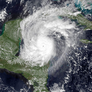
Hurricane Roxanne was a rare and erratic tropical cyclone that caused extensive flooding in Mexico due to its unusual movement. The seventeenth storm, tenth hurricane, and the fifth and final major hurricane of the very active 1995 Atlantic hurricane season, Roxanne developed in the southwestern Caribbean Sea from an area of low pressure on October 7. The depression curved northward, causing it to avoid landfall in Central America. By October 9, the depression intensified enough to be upgraded to Tropical Storm Roxanne. On the following day, Roxanne turned west-northward, where it promptly intensified into a hurricane. As Roxanne headed generally westward, it began to rapidly deepen and reached Category 3 intensity less than 24 hours after becoming a hurricane. Shortly thereafter, Roxanne made landfall near Cozumel, Mexico at its peak intensity, which caused severe damage.

The 1909 Atlantic hurricane season was an average Atlantic hurricane season. The season produced thirteen tropical cyclones, twelve of which became tropical storms; six became hurricanes, and four of those strengthened into major hurricanes. The season's first storm developed on June 15 while the last storm transitioned into an extratropical cyclone on November 14. The most notable storm during the season formed in late August, while east of the Lesser Antilles. The hurricane devastated the Lesser Antilles, the Greater Antilles, and Mexico, leaving around 4,000 fatalities and more than $50 million (1909 USD) in damage.
Hurricane Gordon caused minor damage in the Eastern United States. The seventh named storm and fourth hurricane of the 2000 Atlantic hurricane season, Gordon developed in the extreme western Caribbean Sea from a tropical wave on September 14. Shortly thereafter, the depression moved inland over the Yucatán Peninsula and later emerged into the Gulf of Mexico on September 15. The depression began to quickly organize, and by early on September 16, it was upgraded to Tropical Storm Gordon. After becoming a tropical storm, Gordon continued to intensify and was reclassified as a hurricane about 24 hours later; eventually, the storm peaked as an 80 mph (130 km/h) Category 1 hurricane. However, southwesterly upper-level winds caused Gordon to weaken as it approached land, and it was downgraded to a tropical storm by late on September 17. At 0300 UTC on September 18, Gordon made landfall near Cedar Key, Florida as a strong tropical storm. After moving inland, Gordon rapidly weakened and had deteriorated to tropical depression status by nine hours later. Later that day, Gordon merged with a frontal boundary while centered over Georgia.

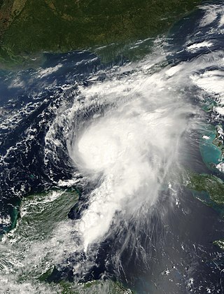
Hurricane Abby made landfall in Cuba, Florida, and North Carolina in June 1968. The first tropical cyclone, first named storm, and first hurricane on the season, Abby developed over the northwestern Caribbean Sea on June 1, as a result of the interaction between a mid-tropospheric trough and a cold front. Moving generally north-northeastward, the depression slowly strengthened while approaching the western tip of Cuba, becoming Tropical Storm Abby late on June 2. Shortly thereafter, Abby made landfall in Pinar del Río Province. The storm dropped heavy rainfall in western Cuba, with up to 12 inches (300 mm) on Isla de la Juventud. However, no flooding was reported. After reaching the southeastern Gulf of Mexico on June 3, Abby strengthened further and became a Category 1 hurricane on the modern-day Saffir–Simpson hurricane wind scale. However, early on June 4, Abby weakened to a tropical storm. Around midday on June 4, the system made landfall near Punta Gorda, Florida as a strong tropical storm.
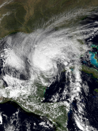
Tropical Storm Keith struck the Continental United States later in the calendar year than any tropical cyclone since the 1925 Atlantic hurricane season. The nineteenth tropical depression and eleventh named storm of the 1988 Atlantic hurricane season, Keith developed out of a tropical wave in the Caribbean Sea on November 17. It tracked northwestward, and under generally favorable conditions, Keith reached a peak intensity of 70 mph (110 km/h) shortly before striking the northeastern tip of the Yucatán Peninsula. It turned northeastward in the Gulf of Mexico, and made landfall near Sarasota, Florida, on November 23. Keith accelerated its forward motion under the influence of a cold front, and became extratropical near Bermuda on November 24. The extratropical remnant persisted for two more days.
The 1995 Atlantic hurricane season was an event in the annual tropical cyclone season in the north Atlantic Ocean. This Atlantic hurricane season saw a near-record number of named tropical storms. This extremely active season followed four consecutive years in which there was below normal activity. The season officially began on June 1, 1995 and ended on November 30, 1995. These dates, adopted by convention, historically describe the period in each year when most tropical systems form. The season's first system, Hurricane Allison, developed on June 3; its last, Hurricane Tanya, became extratropical on November 2.

The 1994 Atlantic hurricane season was the final season in the most recent negative Atlantic multidecadal oscillation period of tropical cyclone formation within the basin. The season produced seven named tropical cyclones and three hurricanes, a total well below the seasonal average. The season officially started on June 1 and ended on November 30, dates which conventionally limit the period each year when most tropical cyclones tend to form in the Atlantic Ocean. The first tropical cyclone, Tropical Storm Alberto, developed on June 30, while the last storm, Hurricane Gordon, dissipated on November 21. The season was unusual in that it produced no major hurricanes, which are those of Category 3 status or higher on the Saffir–Simpson hurricane scale. The most intense hurricane, Hurricane Florence, peaked as a Category 2 storm with winds of 110 mph (180 km/h).
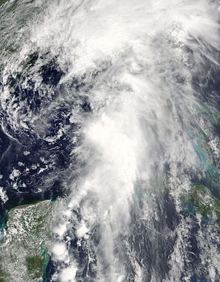
Hurricane Rina was a small and slow-moving, but powerful tropical cyclone that caused minor impacts in the northwestern Caribbean Sea in late October 2011. The seventeenth named storm, seventh and final hurricane, and fourth and final major hurricane of the annual hurricane season, Rina developed from a tropical wave in the western Caribbean on October 23. The depression quickly intensified, and was upgraded to Tropical Storm Rina early on the following day. Further strengthening ensued as it tracked west-northwestward, with Rina becoming a hurricane on October 24. The hurricane eventually peaked as a Category 3 hurricane while it moved generally westward on October 25. However, on October 26, Rina weakened substantially and was downgraded to a Category 1 hurricane. Further weakening occurred, with Rina falling to tropical storm intensity on October 27. Rina then made landfall in northern Quintana Roo early the next day. The cyclone degenerated into a remnant low later on October 28 after emerging into the Yucatán Channel. The low dissipated near the western tip of Cuba on October 29.
Tropical Storm Colin was the earliest third named storm in the Atlantic basin on record for four years, until it was surpassed by Tropical Storm Cristobal in 2020. An atypical, poorly organized tropical cyclone, Colin developed from a low pressure area over the Gulf of Mexico near the northern coast of the Yucatán Peninsula late on June 5, 2016. Moving northward, the depression strengthened into a tropical storm about eight hours after its formation. On June 6, Colin curved to the north-northeast and intensified slightly to winds of 50 mph (80 km/h). Strong wind shear prevented further strengthening and resulted in the system maintaining a disheveled appearance on satellite imagery. Later, the storm began accelerating to the northeast. Early on June 7, Colin made landfall in rural Taylor County, Florida, still at peak intensity. The system rapidly crossed northern Florida and emerged into the Atlantic Ocean several hours later. By late on June 7, Colin transitioned into an extratropical cyclone offshore North Carolina before being absorbed by a frontal boundary the following day.
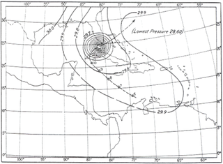
The 1909 Florida Keys hurricane caused severe damage in Cuba and the Florida Keys. The twelfth tropical cyclone and fifth hurricane of season, the storm was first detected in the Caribbean Sea offshore Colombia on October 6. Initially a tropical depression, the system became a tropical storm early on the next day while heading northwestward. By October 8, the storm became a Category 1 hurricane on the modern day Saffir–Simpson hurricane wind scale to the southwest of Jamaica. The hurricane curved to the west-northwest and intensified throughout the next day, becoming Category 3 intensity late on October 9. A major hurricane, the cyclone peaked with sustained winds of 120 mph (195 km/h) early on October 10. Later that day, it turned to the north and made landfall in Pinar del Río Province. After traversing the western extremity of Cuba, the storm entered the Straits of Florida and turned northeastward. The hurricane made landfall near Marathon, Florida, late on October 11 with winds of 115 mph (185 km/h). Thereafter, the system weakened quickly while crossing the northwestern Bahamas and the western Atlantic Ocean, falling to tropical storm intensity late on October 12. About 24 hours later, it weakened to a tropical depression and subsequently dissipated northeast of Bermuda.

Tropical Storm Alberto was a destructive pre-season tropical cyclone which caused $125 million in damage in the Gulf Coast of the United States in May 2018, the costliest for any pre-season tropical cyclone. The first storm of the 2018 Atlantic hurricane season, Alberto developed on May 25 near the Yucatán Peninsula as a subtropical cyclone. As it entered the Gulf of Mexico, Alberto intensified and transitioned into a tropical cyclone. Early on May 28, Alberto reached its peak intensity, with maximum sustained winds of 65 mph (100 km/h) and a minimum pressure of 990 mbar. Afterward, however, dry air caused Alberto to weaken before it made landfall near Laguna Beach, Florida, with winds of 45 mph (75 km/h). Alberto maintained a compact area of thunderstorms as it progressed through the central United States, entering southern Michigan as a tropical depression on May 31. That day, Alberto weakened further and dissipated over Ontario.

Hurricane Marco was the first of two tropical cyclones to threaten the Gulf Coast of the United States within a three-day period. The thirteenth named storm and third hurricane of the record-breaking 2020 Atlantic hurricane season, Marco developed from a fast-moving tropical wave west of the Windward Islands and south of Jamaica on August 20. The fast motion of the wave inhibited intensification initially, but as the wave slowed down and entered a more favorable environment, the system developed into a tropical depression, which in turn rapidly intensified into a strong tropical storm. Due to strong wind shear, Marco's intensification temporarily halted. However, after entering the warm waters of the Gulf of Mexico on August 23, Marco briefly intensified into a hurricane, only to quickly weaken later that evening due to another rapid increase in wind shear. Marco subsequently weakened to a tropical depression before degenerating into a remnant low early the next morning. Marco's remnants subsequently dissipated on August 26.

Hurricane Delta was a destructive tropical cyclone that became the record-tying fourth named storm of 2020 to make landfall in Louisiana, as well as the record-breaking tenth named storm to strike the United States in that year. The twenty-sixth tropical cyclone, twenty-fifth named storm, tenth hurricane, and third major hurricane of the record-breaking 2020 Atlantic hurricane season, Delta formed from a tropical wave which was first monitored by the National Hurricane Center (NHC) on October 1. Moving westward, the tropical wave began to quickly organize. A well-defined center of circulation formed with sufficiently organized deep convection on October 4, and was designated as Tropical Depression Twenty-six and soon thereafter, Tropical Storm Delta. Extremely rapid intensification ensued throughout October 5 into October 6, with Delta becoming a Category 4 hurricane within 28 hours of attaining tropical storm status. The rate of intensification was the fastest in the Atlantic basin since Hurricane Wilma in 2005. After peaking in intensity however, an unexpected increase in wind shear and dry air quickly weakened the small storm before it made landfall in Puerto Morelos, Mexico as a Category 2 hurricane with 105 mph (169 km/h) winds. It weakened some more over land before emerging into the Gulf of Mexico, where it was downgraded to a Category 1 hurricane. After that, it began to restrengthen, regaining Category 3 status late on October 8. It then turned northward and reached a secondary peak intensity of 953 mbar (28.14 inHg) and winds of 120 mph early on October 9. Delta then began to turn more north-northeastward into an area of cooler waters, higher wind shear, and dry air, causing it to weaken back to Category 2 status. Delta then made landfall at 23:00 UTC near Creole, Louisiana with winds of 100 mph (160 km/h) and a pressure of 970 mbar (29 inHg). The storm began to weaken more rapidly after landfall, becoming post-tropical just 22 hours later.

Hurricane Grace was the strongest tropical cyclone to make landfall in the Mexican state of Veracruz. Grace impacted much of the Leeward Islands and Greater Antilles as a tropical storm, before causing more substantial impacts in the Yucatán Peninsula and Veracruz as a hurricane. It was the seventh named storm, second hurricane, and first major hurricane of the 2021 Atlantic hurricane season. Originating from a tropical wave in the Main Development Region, the primitive system tracked west-northwest across the Atlantic Ocean towards the Antilles, becoming a tropical depression on August 14. It strengthened into Tropical Storm Grace later the same day, but weakened back to a depression due to an unfavorable environment. After moving near Haiti as a tropical depression, it strengthened back to a tropical storm and became a hurricane on August 18, reaching an initial peak intensity with maximum sustained winds of 80 mph (130 km/h) and a pressure of 986 mbar (29.12 inHg). It weakened back to a tropical storm after its landfall in the Yucatán Peninsula and emerged into the Bay of Campeche, entering a very favorable environment for intensification hours later. Grace then rapidly intensified into a Category 3 hurricane with winds of 120 mph (190 km/h) in about 24 hours. The storm made its final landfall in the state of Veracruz at peak intensity and quickly degenerated into a remnant low over mainland Mexico on August 21; however, its remnants later regenerated into Tropical Storm Marty in the Eastern Pacific on August 23.


