X
| | This section is empty. You can help by adding to it. (July 2020) |
Articles related to the Canadian province of Newfoundland and Labrador include:
| | This section is empty. You can help by adding to it. (July 2020) |
| | This section is empty. You can help by adding to it. (July 2020) |

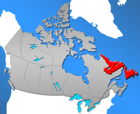
Newfoundland and Labrador is the easternmost province of Canada, in the country's Atlantic region. The province comprises the island of Newfoundland and the continental region of Labrador, having a total size of 405,212 square kilometres. In 2021, the population of Newfoundland and Labrador was estimated to be 521,758. The island of Newfoundland is home to around 94 per cent of the province's population, with more than half residing in the Avalon Peninsula. Labrador borders the province of Quebec, and the French overseas collectivity of Saint Pierre and Miquelon lies about 20 km west of the Burin Peninsula.

The Province of Avalon was the area around the English settlement of Ferryland in what is now Newfoundland and Labrador, Canada in the 17th century, which upon the success of the colony grew to include the land held by Sir William Vaughan and all the land that lay between Ferryland and Petty Harbour.

Carbonear is a town on the Avalon Peninsula in Newfoundland and Labrador, Canada. It overlooks the west side of Conception Bay and had a history long tied to fishing and shipbuilding. Since the late 20th century, its economy has changed to emphasize education, health care, retail, and industry. As of 2021, there were 4,696 people in the community.

Grates Cove is a local service district and designated place in the Canadian province of Newfoundland and Labrador. It is the most northerly community on the Avalon Peninsula, located on the tip of the Bay de Verde Peninsula on the island of Newfoundland. Called "the Grates" by John Guy as early as 1612, the origin of the name is unknown.

Caplin Cove is a small community on the north shore of Conception Bay, Newfoundland and Labrador, Canada. It is surrounded on the north by Low Point near the end of the Bay de Verde Peninsula, and on the south by Lower Island Cove. Caplin Cove was probably named for the large body of capelin in its waters.

Portugal Cove–St. Philip's is a rural seashore community located on the eastern Avalon Peninsula of Newfoundland in the province of Newfoundland and Labrador, Canada. The town is a bedroom community of the provincial capital of St. John's.

Northern Bay is a small community on the northern tip of Conception Bay on the Bay de Verde Peninsula, Subdivision 1G, Newfoundland and Labrador, Canada.
Conche is a community on the Northern Peninsula of Newfoundland and Labrador, Canada. Its population in 2021 was 149.
Port de Grave is a peninsula on Conception Bay (CB) in Newfoundland and Labrador, Canada. The peninsula contains the communities of Bareneed, Black Duck Pond, Otterbury, Ship Cove, Blow Me Down, Hibb's Cove, Pick Eyes, and Hussey's Cove with a population of approximately 975 (2006). This community is located in the provincial electoral district of Port de Grave. An unincorporated area, for statistics purposes it is called Division No. 1, Subdivision L. The Peninsula is accessible by road via Route 72.
Tors Cove is a local service district and designated place in the Canadian province of Newfoundland and Labrador. It is on the east coast of the Avalon Peninsula of the island of Newfoundland, approximately 40 kilometres south of the St. John's, the provincial capital, along Route 10. It was formerly named Toads Cove.
The East Coast Trail (ECT) is a long-distance coastal footpath located in the Canadian province of Newfoundland and Labrador. It is a developed trail over 336 kilometres (209 mi) long, creation of which began in 1994. It is made up of 25 linked wilderness paths and passes through more than 30 communities. It was named one of the best adventure destinations by National Geographic in 2012 and is extended and improved yearly.

The province of Newfoundland and Labrador covers the period from habitation by Archaic peoples thousands of years ago to the present day.
Bay de Verde is an incorporated town in Conception Bay on the northern tip of the Bay de Verde Peninsula of Newfoundland and Labrador, Canada. The first recorded inhabitants at Bay de Verde arrived in 1662. Bay de Verde became an incorporated town in 1950.
Noggin Cove is a local service district and designated place in the Canadian province of Newfoundland and Labrador. It is west of Carmanville on the south side of Hamilton Sound. It is said to be named after Noggin Island, about 5 km off its eastern point.

The Canadian province of Newfoundland and Labrador is governed by a unicameral legislature, the House of Assembly, which operates under the Westminster model of government. The executive function of government is formed by the Lieutenant Governor, the premier and his or her cabinet. The politics of Newfoundland and Labrador is defined by a long history, liberal democratic political institutions and a unique political culture.

Coachman's Cove is a town in the Canadian province of Newfoundland and Labrador. The town had a population of 111 in the Canada 2021 Census.

Witless Bay is a town on the Avalon Peninsula in the Canadian province of Newfoundland and Labrador. Located on the Irish Loop, 35 km south of the provincial capital, St. John's, Witless Bay is a small, scenic, traditional Newfoundland outport community. The town had a population of 1640 in the Canada 2021 Census. It is connected to the Witless Bay Ecological Reserve.
Division No. 1, Subdivision G is an unorganized subdivision on the Avalon Peninsula in Newfoundland and Labrador, Canada. It is in Division 1 and contains the unincorporated communities of Baccalieu Island, Besom Cove, Bradley's Cove, Burnt Point, Caplin Cove, Daniel's Cove, Grates Cove, Gull Island, Job's Cove, Kingston, Long Beach, Lower Island Cove, Low Point, Northern Bay, Ochre Pit Cove, Red Head Cove, Riverhead, Smooth Cove and Western Bay.
The following outline is provided as an overview of and topical guide to Newfoundland and Labrador.
Caplin Cove-Southport is a local service district and designated place in Trinity Bay in the Canadian province of Newfoundland and Labrador. Caplin Cove-Southport is approximately 50 km from Clarenville.