The City of Tea Tree Gully is a local council in the Australian state of South Australia, in the outer north-eastern suburbs of Adelaide. The major business district in the city is at Modbury, where Westfield Tea Tree Plaza, the Civic Centre and the library are located.

Adelaide Hills Council is a local government area in the Adelaide Hills of South Australia. It is in the hills east of Adelaide, the capital of South Australia, and extends from the South Para Reservoir in the north to the Mount Bold Reservoir in the south.

Birdwood is a town near Adelaide, South Australia. It is located in the local government areas of the Adelaide Hills Council and the Mid Murray Council.

Cudlee Creek is a small town near Adelaide, South Australia. It is located in the Adelaide Hills Council local government area.

Gulfview Heights is a small suburb of Adelaide, South Australia and is within the City of Salisbury and City of Tea Tree Gully local government area. It is adjacent to Wynn Vale, Salisbury East and Para Hills.

Tennyson is a suburb in the Australian state of South Australia located in the Adelaide metropolitan area about 11 kilometres (6.8 mi) north-west of the Adelaide city centre and about 4.8 kilometres (3.0 mi) west of the municipal seat of Woodville.

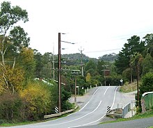
Houghton is a small town near Adelaide, South Australia. It is located in the Adelaide Hills, in the City of Tea Tree Gully and the Adelaide Hills Council local government areas between Tea Tree Gully and Inglewood on the North East Road.
Upper Hermitage is an outer northeastern rural suburb of Adelaide, South Australia. It is located in the City of Tea Tree Gully and Adelaide Hills Council local government areas, and is adjacent to the rural districts of Yatala Vale and Gould Creek.
Gould Creek is an outer northeastern rural suburb of Adelaide, South Australia. Gould Creek is located in the City of Tea Tree Gully and City of Playford local government areas, and is adjacent to Greenwith, Salisbury Heights and Hillbank, as well as the rural districts of Yatala Vale and Upper Hermitage and the town of One Tree Hill.
Chain of Ponds is a locality and former town near Adelaide, South Australia. It is located in the Adelaide Hills Council local government area.
Paracombe is a small town near Adelaide, South Australia. At the 2011 census, Paracombe had a population of 343.

Gumeracha is a town in the Adelaide Hills, South Australia, located on the Adelaide-Mannum Road. It is located in the Adelaide Hills Council local government area on the south bank of the upper River Torrens. At the 2006 census, Gumeracha had a population of 731.
Forreston is a locality near Adelaide, South Australia. It is located in the Adelaide Hills Council local government area 3 km northeast of Gumeracha.

Palmer is a town just east of the Adelaide Hills region of South Australia along the Adelaide-Mannum Road, 70 kilometres east-north-east of the state capital, Adelaide and 15 km west-north-west of Mannum. It is located in the Mid Murray Council local government area. At the 2006 census, Palmer had a population of 329.

Mount Torrens is a town in the eastern Adelaide Hills region of South Australia, 46 kilometres east-north-east of the state capital, Adelaide and 8 km east of Lobethal. It is located in the Adelaide Hills Council and the Mid Murray Council local government areas. At the 2006 census, Mount Torrens had a population of 337.

Valley View is a suburb of Adelaide, South Australia. It spans three separate local government areas. They are the City of Salisbury, the City of Port Adelaide Enfield, and the City of Tea Tree Gully. The suburb's boundaries are defined by the intersection of Walkleys, Grand Junction and North East Roads in the south, and Wright and Kelly Roads in the north and east.

Sellicks Beach, formerly spelt Sellick's Beach, is a suburb in the Australian state of South Australia located within Adelaide metropolitan area about 47 kilometres (29 mi) from the Adelaide city centre. It is an outer southern suburb of Adelaide and is located in the local government area of the City of Onkaparinga at the southern boundary of the metropolitan area. It is known as Witawali or Witawodli by the traditional owners, the Kaurna people, and is of significance as being the site of a freshwater spring said to be created by the tears of Tjilbruke, the creator being.
The District Council of Highercombe was a local government area in South Australia from 1853 to 1935.
The Hundred of Para Wirra is a cadastral hundred of the County of Adelaide, South Australia, spanning a portion of the Adelaide Hills north of the Torrens Valley including Mount Crawford.
Mount Crawford is a locality in the Mount Lofty Ranges of South Australia. It is named after the mountain of the same name in its boundaries, also known as Teetaka.