Inka Qhamachu

Last updated
Inka Qhamachu
Bolivia physical map.svg
Red triangle with thick white border.svg
Inka Qhamachu
Highest point
Elevation 4,792 m (15,722 ft) [1]
Coordinates 18°51′13″S68°12′42″W / 18.85361°S 68.21167°W / -18.85361; -68.21167 Coordinates: 18°51′13″S68°12′42″W / 18.85361°S 68.21167°W / -18.85361; -68.21167
Geography
Location Bolivia
Oruro Department
Parent range Andes

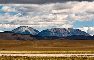
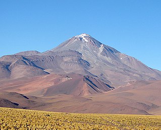
Inka Qhamachu (Quechua Inka Inca, qhamachu a species of wild tobacco (Nicotiana glauca), [2] Hispanicized names Inca Camacho, Incacamachi) is a 4,792-metre-high (15,722 ft) mountain in the Andes of Bolivia. It is located in the Oruro Department, Litoral Province, Huachacalla Municipality. Inka Qhamachu lies southeast of Pacha Qullu, southeast of the village of Huachacalla (Wachaqalla). [3]

Inca Empire empire in pre-Columbian America

The Inca Empire, also known as the Incan Empire and the Inka Empire, was the largest empire in pre-Columbian America. Its political and administrative structure is considered by most scholars to have been the most developed in the Americas before Columbus' arrival. The administrative, political and military center of the empire was located in the city of Cusco. The Inca civilization arose from the Peruvian highlands sometime in the early 13th century. Its last stronghold was conquered by the Spanish in 1572.

<i>Nicotiana glauca</i> species of plant

Nicotiana glauca is a species of wild tobacco known by the common name tree tobacco. Its leaves are attached to the stalk by petioles, and its leaves and stems are neither pubescent nor sticky like Nicotiana tabacum. It resembles Cestrum parqui but differs in the form of leaves and fusion of the outer floral parts. It grows to heights of more than two meters.

Andes mountain range running along the tu mamide of South America

The Andes or Andean Mountains are the longest continental mountain range in the world, forming a continuous highland along the western edge of South America. This range is about 7,000 km (4,300 mi) long, about 200 to 700 km wide, and of an average height of about 4,000 m (13,000 ft). The Andes extend from north to south through seven South American countries: Venezuela, Colombia, Ecuador, Peru, Bolivia, Chile and Argentina.

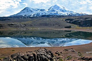
Inka Qhamachu is part of the Altiplano, an area of the Andes lying at altitudes of 3,600–4,000 metres (11,800–13,100 ft). The Altiplano has been affected by volcanic activity. Most of it including Inka Qhamachu is extinct, but in the Western Cordillera volcanic activity persists at Cerro Quemado, Guallatiri, Parinacota, Sajama and Tata Sabaya. [4]

Altiplano plateau

The Altiplano, Collao, Andean Plateau or Bolivian Plateau, in west-central South America, is the area where the Andes are the widest. It is the most extensive area of high plateau on Earth outside Tibet. The bulk of the Altiplano lies in Bolivia, but its northern parts lie in Peru, and its southern parts lie in Chile and Argentina.

Cerro Quemado is a mountain in the Andes Mountains of Argentina. It has a height of 6,184 metres (20,289 ft).

Guallatiri mountain in Parinacota Province Chile

Guallatiri is a 6,071-metre-high (19,918 ft) volcano in Chile. It is located southwest of the Nevados de Quimsachata volcanic group and is sometimes considered to be part of that group. It is a stratovolcano with fumaroles around the summit, which may be either a lava dome or a pyroclastic cone. The lower flanks of the volcano are covered by lava flows and lava domes; the volcano has erupted mainly dacite along with andesite and rhyolite.

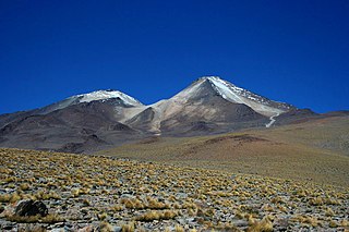
Inka Qhamachu is a Pliocene age volcano, [4] which rises from an altitude of 3,700 metres (12,100 ft). [5] Its slopes range 11–16°, formed by lava flows and pyroclastic material. Erosion has carved radial gullies into its flanks, at whose ends alluvial fans have formed. [4] Based on the degree of erosion, an age of 7.5 million years has been estimated. The volume of the edifice once was about 50.9 cubic kilometres (12.2 cu mi). [5]

The Pliocene Epoch is the epoch in the geologic timescale that extends from 5.333 million to 2.58 million years BP. It is the second and youngest epoch of the Neogene Period in the Cenozoic Era. The Pliocene follows the Miocene Epoch and is followed by the Pleistocene Epoch. Prior to the 2009 revision of the geologic time scale, which placed the four most recent major glaciations entirely within the Pleistocene, the Pliocene also included the Gelasian stage, which lasted from 2.588 to 1.806 million years ago, and is now included in the Pleistocene.

Temperatures in the closely located city of Oruro range 4–12 °C (39–54 °F), and precipitation is 400–100 millimetres (15.7–3.9 in). The area is very windy. This climate has led to a xerophytic vegetation, including shrubs and tussock grass. [4]

Oruro, Bolivia City in Oruro Department, Bolivia

Oruro or Uru Uru is a city in Bolivia with a population of 264,683, about halfway between La Paz and Sucre in the Altiplano, approximately 3,709 meters (12,169 ft) above sea level.

Shrub type of plant

A shrub or bush is a small- to medium-sized woody plant. Unlike herbaceous plants, shrubs have persistent woody stems above the ground. They are distinguished from trees by their multiple stems and shorter height, and are usually under 6 m (20 ft) tall. Plants of many species may grow either into shrubs or trees, depending on their growing conditions. Small, low shrubs, generally less than 2 m (6.6 ft) tall, such as lavender, periwinkle and most small garden varieties of rose, are often termed "subshrubs".

Related Research Articles

Geography of Bolivia

The geography of Bolivia includes the Eastern Andes Mountain Range which bisects Bolivia roughly from north to south. To the east of that mountain chain are lowland plains of the Amazon Basin, and to the west is the Altiplano which is a highland plateau where Lake Titicaca is located. Bolivia's geography has features similar to those of Peru which abuts Bolivia's northwest border; like Bolivia, Peru is bisected from north to south by the Eastern Andes Mountains, and these two countries share Lake Titicaca which is the highest navigable lake on Earth. Unlike Peru, however, Bolivia is one of the two landlocked countries in South America, the other being Paraguay which is located along Bolivia's southeast border.

Litoral Province (Bolivia) Province in Oruro, Bolivia

Litoral is a province in the southwestern parts of the Bolivian Oruro Department. Its seat is Huachacalla.

Incahuasi mountain in Argentina

Incahuasi is a volcanic mountain in the Andes of South America. It lies on the border of the Argentine province of Catamarca, and the Atacama Region of Chile. Incahuasi has a summit elevation of 6,621 metres (21,722 ft) above sea level.

Ampato dormant Peruvian volcano

Ampato is a dormant 6,288-metre (20,630 ft) stratovolcano in the Andes of southern Peru. It lies about 70–75 kilometres (43–47 mi) northwest of Arequipa and is part of a north-south chain that includes the volcanoes Hualca Hualca and Sabancaya, the last of which has been active in historical time.

Cerro del León mountain in Chile

Cerro del León is a stratovolcano located in El Loa province, Antofagasta Region, Chile. It is part of the Chilean Central Volcanic Zone and forms a volcanic lineament with neighbouring Paniri and Toconce that was active into the Holocene. Cerro del León itself was constructed in three stages by andesitic–dacitic lava flows and was subject to glacial erosion.

Auquihuato mountain

Auquihuato is a cinder cone in the Andes of Peru, 4,980 metres (16,339 ft) high. It is situated in the Ayacucho Region, Paucar del Sara Sara Province, on the border of the districts Colta and Oyolo. Auquihuato lies northeast of Sara Sara volcano.

Quimsachata (Canchis) mountain in Peru

Quimsachata is an extinct volcano in the Andes of Peru. It is located in the Cusco Region, Canchis Province at about 24 kilometres (15 mi) northwest of the town of Sicuani. This volcano is constructed from two separate centres, one active 11,500 years ago which formed a scoria cone and a lava field and another active 4450 BCE which formed two lava flows and a lava dome.

Incahuasi (Apurímac) mountain in Peru

Incahuasi is a mountain in the Vilcabambamountain range in the Andes of Peru whose summit reaches 4,315 metres (14,157 ft) above sea level. It is situated in the Apurímac Region, Abancay Province, Cachora District. The mountain lies on the bank of the Apurímac River, opposite the archaeological site of Choquequirao. On its northern slope there is a small archaeological site named Inka Raqay. Tourists are also attracted by the viewpoint of Incahuasi which provides good views of the Apurímac valley, Choquequirao and Padreyoc.

Inka Pukara (Oruro)

Inka Pukara is a 4,444-metre-high (14,580 ft) mountain in the Andes of Bolivia. It is located in the Oruro Department, Pantaleón Dalence Province, Huanuni Municipality. Inka Pukara lies southeast of Huanuni. The village of Pukara (Pucara) lies at its feet.

Uturunku stratovolcano

Uturunku is a dormant volcano in the Cordillera de Lípez in Potosí Department, Bolivia. It is located in the Sur Lípez Province, San Pablo de Lípez Municipality. It is in the Central Volcanic Zone of the Andes, and its highest summit is 6,008 metres (19,711 ft) above sea level. The volcano has two summits, with a fumarole field between them. The volcano's landforms include lava domes and lava flows.

Cerro Guacha

Cerro Guacha is a Miocene caldera in southwestern Bolivia's Sur Lípez Province. Part of the volcanic system of the Andes, it is considered to be part of the Central Volcanic Zone (CVZ), one of the three volcanic arcs of the Andes, and its associated Altiplano-Puna volcanic complex (APVC). A number of volcanic calderas occur within the latter.

Altiplano Basin

The Altiplano Basin is a sedimentary basin within the Andes in Bolivia and Peru. The basin is located on the Altiplano plateau between the Cordillera Occidental and the Cordillera Oriental. Over-all the basin has evolved through time in a context of horizontal shortening of Earth's crust. The great thickness of the sediments accumulated in the basin is mostly the result of the erosion of Cordillera Oriental.

Pacha Qullu mountain in Bolivia

Pacha Qullu or Kimsa Misa is a 4,702-metre-high (15,427 ft) mountain in the Andes of Bolivia. It is located in the Oruro Department, Litoral Province, Huachacalla Municipality, west of Huachacalla (Wachaqalla). Pacha Qullu lies northwest of Inka Qhamachu. The plain at 18°42′44.86″S68°34′25.21″W northwest of Pacha Qullu is named Kimsa Misa Pampa (Quimsa Misa Pampa).

Coropuna volcano in Peru

Coropuna is a dormant volcano in the southern Peruvian Andes that belongs to the Central Volcanic Zone; it has several summits, the highest of which reaches an altitude of 6,377 metres above sea level. The volcano, located 150 kilometres from Arequipa, is mostly made of ignimbrites and lava flows on a basement formed by additional ignimbrites and lava flows, some of which may have been formed by Coropuna itself. Coropuna has been active for at least five million years, with the bulk of the current cone having formed during the Quaternary. It has had three Holocene eruptions 6,000, 2,100 ± 200 and either 1,100 ± 100 or 700 ± 200 years ago which generated lava flows. Currently, activity occurs exclusively in the form of hot springs

Lake Mataro is an ancient lake in the Andes. It formed over the northern Altiplano at an altitude of 3,950 metres (12,960 ft) and extended over the central Altiplano. It is one of the ancient lakes of the Altiplano like Lake Minchin, Lake Ballivian and Lake Cabana. It existed between 2.8 and 1.8 million years ago.

Llullaillaco Dormant stratovolcano at the border of Argentina and Chile

Llullaillaco is a dormant stratovolcano at the border of Argentina and Chile. It lies in the Puna de Atacama, a region of tall volcanic peaks on a high plateau close to the Atacama Desert, one of the driest places in the world. It is the second highest active volcano in the world after Ojos del Salado.

Tata Sabaya mountain

Tata Sabaya is a 5,430-metre (17,810 ft) high volcano in Bolivia. It is part of the Central Volcanic Zone, one of several volcanic belts in the Andes which are separated by gaps without volcanic activity. This section of the Andes was volcanically active since the Jurassic, with an episode of strong ignimbritic volcanism occurring during the Miocene. Tata Sabaya lies in a thinly populated region north of the Salar de Coipasa salt pan.

Nevado Sajama mountain

Nevado Sajama is an extinct stratovolcano and the highest peak in Bolivia. The mountain is located in the Oruro Department, Sajama Canton. It is situated in Sajama National Park and is a composite volcano consisting of a stratovolcano on top of several lava domes. It is not clear when it erupted last but it may have been during the Pleistocene or Holocene.

References

  1. Bolivian IGM map 1:50,000 Escara 5937-II
  2. Diccionario Quechua - Español - Quechua, Academía Mayor de la Lengua Quechua, Gobierno Regional Cusco, Cusco 2005 (Quechua-Spanish dictionary) see: supay qarqo
  3. "Huachacalla". Archived from the original on March 4, 2016. Retrieved January 15, 2016. (unnamed)
  4. 1 2 3 4 Rossi, Matti J.; Kesseli, Risto; Liuha, Petri; Meneses, Jédu Sagárnaga; Bustamante, Jonny (October 2002). "A preliminary archaeological and environmental study of pre-Columbian burial towers at Huachacalla, Bolivian Altiplano". Geoarchaeology. 17 (7): 633–648. doi:10.1002/gea.10032.
  5. 1 2 Karátson, D.; Telbisz, T.; Wörner, G. (February 2012). "Erosion rates and erosion patterns of Neogene to Quaternary stratovolcanoes in the Western Cordillera of the Central Andes: An SRTM DEM based analysis". Geomorphology. 139-140: 122–135. doi:10.1016/j.geomorph.2011.10.010.