Interlake Formation

Last updated
Interlake Formation (Group)
Stratigraphic range: Llandovery to Ludlow
Type Geological formation
Underlies Ashern Formation
Overlies Stonewall Formation
Thicknessup to 335 metres (1,100 ft) [1]
Lithology
Primary dolomite
Location
Coordinates 51°27′13″N98°45′37″W / 51.4535°N 98.7603°W / 51.4535; -98.7603 (Interlake Formation)
Region WCSB
Williston Basin
CountryFlag of Canada (Pantone).svg  Canada
Flag of the United States.svg  United States
Type section
Named for Interlake Region, Manitoba
Named byA.D. Baillie, 1951
Interlake Formation within Williston Basin stratigraphy Williston Basin stratigraphic column.jpg
Interlake Formation within Williston Basin stratigraphy

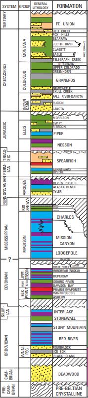
The Interlake Formation is a stratigraphical unit of Silurian age in the Western Canadian Sedimentary Basin.

Contents

It takes the name from the Interlake Region in Manitoba, and was first described in outcrop by A.D. Baillie in 1951. [2]

Lithology

The Interlake Formation is composed of very finely crystalline dolomite. [1] Oolitic, stromatolitic and biohermal interbeds also occur.

Distribution

The Interlake Formation is present throughout the Williston Basin. [1] It reaches a maximum thickness of 335 metres (1,100 ft) in the subsurface of North Dakota, and is typically up to 110 metres (360 ft) thick in outcrop in its type locality.

Relationship to other units

The Interlake Formation is overlain with an angular unconformably by the Ashern Formation and sharply overlays the Stonewall Formation. [1]

In the sub-surface it is given group status and contains, in different regions, the following subdivisions:

Related Research Articles

<span class="mw-page-title-main">Williston Basin</span> Sedimentary basin in Montana, United States

The Williston Basin is a large intracratonic sedimentary basin in eastern Montana, western North Dakota, South Dakota, southern Saskatchewan, and south-western Manitoba that is known for its rich deposits of petroleum and potash. The basin is a geologic structural basin but not a topographic depression; it is transected by the Missouri River. The oval-shaped depression extends approximately 475 miles (764 km) north-south and 300 miles (480 km) east-west.

<span class="mw-page-title-main">Foremost Formation</span>

The Foremost Formation is a stratigraphic unit of Late Cretaceous (Campanian) age that underlies much of southern Alberta, Canada. It was named for outcrops in Chin Coulee near the town of Foremost and is known primarily for its dinosaur remains and other fossils.

<span class="mw-page-title-main">Cadomin Formation</span>

The Cadomin Formation is a stratigraphic unit of Early Cretaceous age in the western part of the Western Canada Sedimentary Basin. It is extends from southeastern British Columbia through western Alberta to northeastern British Columbia, and it contains significant reservoirs of natural gas in some areas. It was named after the mining town of Cadomin, which is an acronym of "Canadian Dominion Mining".

The Exshaw Formation is a stratigraphic unit in the Western Canada Sedimentary Basin. It takes the name from the hamlet of Exshaw, Alberta in the Canadian Rockies, and was first described from outcrops on the banks of Jura Creek north of Exshaw by P.S. Warren in 1937. The formation is of Late Devonian to Early Mississippian age as determined by conodont biostratigraphy, and it straddles the Devonian-Carboniferous boundary.

The Mist Mountain Formation is a geologic formation of latest Jurassic to earliest Cretaceous age in the Western Canada Sedimentary Basin that is present in the southern and central Canadian Rockies. It was named for outcrops along the western spur of Mist Mountain in Alberta by D.W. Gibson in 1979. The Mist Mountain Formation contains economically important coal seams that have been mined in southeastern British Columbia and southwestern Alberta.

The Beaverhill Lake Group is a geologic unit of Middle Devonian to Late Devonian age in the Western Canada Sedimentary Basin that is present in the southwestern Northwest Territories, northeastern British Columbia and Alberta. It was named by the geological staff of Imperial Oil in 1950 for Beaverhill Lake, Alberta, based on the core from a well that they had drilled southeast of the lake, near Ryley, Alberta.

<span class="mw-page-title-main">Elk Point Group</span>

The Elk Point Group is a stratigraphic unit of Early to Middle Devonian age in the Western Canada and Williston sedimentary basins. It underlies a large area that extends from the southern boundary of the Northwest Territories in Canada to North Dakota in the United States. It has been subdivided into numerous formations, number of which host major petroleum and natural gas reservoirs.

The Pakowki Formation is a stratigraphical unit of Campanian age in the Western Canadian Sedimentary Basin.

The Manitoba Group is a stratigraphical unit of middle to late Devonian age in the Western Canadian Sedimentary Basin.

The Stonewall Formation is a stratigraphical unit of Late Ordovician to Early Silurian age in the Western Canadian Sedimentary Basin.

The Stony Mountain Formation is a stratigraphical unit of Ashgill age in the Western Canadian Sedimentary Basin.

The Red River Formation is a stratigraphical unit of Late Ordovician age in the Williston Basin.

The Elk Formation is a stratigraphic unit of the Western Canada Sedimentary Basin that is present in southeastern British Columbia and southwestern Alberta. It is probably of Early Cretaceous age, but in some areas its strata could be as old as Late Jurassic. It includes minor thin coal beds and was named for outcrops near the now-abandoned Elk River coal mine east of Fernie, British Columbia.

<span class="mw-page-title-main">Cairn Formation</span>

The Cairn Formation is a geologic formation of Late Devonian (Frasnian) age in the Western Canada Sedimentary Basin. It was named for the Cairn River near its junction with the Southesk River in Jasper National Park by D.J. McLaren in 1955.

The Perdrix Formation is a geologic formation of Late Devonian (Frasnian) age in the Western Canada Sedimentary Basin. It named for Roche à Perdrix in Jasper National Park, Alberta, by P.E. Raymond in 1930. It includes fossils of marine animals.

<span class="mw-page-title-main">Prairie Evaporite Formation</span> Geologic formation of Givetian age

The Prairie Evaporite Formation, also known as the Prairie Formation, is a geologic formation of Middle Devonian (Givetian) age that consists primarily of halite and other evaporite minerals. It is present beneath the plains of northern and eastern Alberta, southern Saskatchewan and southwestern Manitoba in Canada, and it extends into northwestern North Dakota and northeastern Montana in the United States.

The Gladstone Formation is a stratigraphic unit of Early Cretaceous (Aptian) age in the Western Canada Sedimentary Basin. It is present in the foothills of southwestern Alberta and is named for outcrops along Gladstone Creek, a tributary of the Castle River south of the Crowsnest Pass.

The La Loche Formation is a geologic formation of early Middle Devonian (Eifelian) age in the Western Canada Sedimentary Basin. It is present in northeastern Alberta and northwestern Saskatchewan and was first described by A. W. Norris in 1963, who named it for a Roman Catholic Mission at Lac La Loche. Its type section is located at Contact Rapids on the Clearwater River in Saskatchewan, northwest of Lac La Loche. It is not fossiliferous.

The Arctomys Formation is a stratigraphic unit of late Middle Cambrian age. It is present on the western edge of the Western Canada Sedimentary Basin in the Canadian Rockies of Alberta and British Columbia. It was named for Arctomys Peak near Mount Erasmus in Banff National Park by Charles Doolittle Walcott in 1920. Outcrops of the Arctomys can be seen in Banff and Jasper National Parks.

The Bertie Group or Bertie Limestone, also referred to as the Bertie Dolomite and the Bertie Formation, is an upper Silurian geologic group and Lagerstätte in southern Ontario, Canada, and western New York State, United States. Details of the type locality and of stratigraphic nomenclature for this unit as used by the U.S. Geological Survey are available on-line at the National Geologic Map Database. The formation comprises dolomites, limestones and shales and reaches a thickness of 495 feet (151 m) in the subsurface, while in outcrop the group can be 60 feet (18 m) thick.

References

  1. 1 2 3 4 Lexicon of Canadian Geologic Units. "Formation". Archived from the original on 2009-04-16. Retrieved 2010-02-01.
  2. Ballie, A.D., 1951 Silurian geology of the Interlake area, Manitoba. Manitoba Department of Mines and Natural Resources, Mines Branch, Pub. 50-1.