Ravenscrag Formation

Last updated
Ravenscrag Formation
Stratigraphic range: Paleocene
Type Geological formation
Sub-unitsUpper Ravenscrag
Lower Ravenscrag
Underlies Swift Current Formation
Overlies Frenchman Formation
Thicknessup to 244 metres (800 ft) [1]
Lithology
Primary Claystone, mudstone, siltstone
Other Sandstone, coal
Location
Coordinates 49°30′07″N108°58′33″W / 49.50182°N 108.97585°W / 49.50182; -108.97585 (Ravenscrag Formation)
Region Western Canada Sedimentary Basin:
Flag of Alberta.svg  Alberta
Flag of Saskatchewan.svg  Saskatchewan
CountryFlag of Canada (Pantone).svg  Canada
Type section
Named for Ravenscrag, Saskatchewan
Named byN.B. Davis, 1918

The Ravenscrag Formation is a stratigraphic unit of early Paleocene age in the Western Canada Sedimentary Basin. [2] It was named for the settlement of Ravenscrag, Saskatchewan, and was first described from outcrops at Ravenscrag Butte near the Frenchman River by N.B. Davis in 1918. [3]

Contents

The Ravenscrag Formation includes a wide range of vertebrate and plant fossils, as well as economically significant coal seams [4] and clay deposits. [3]

Lithology

The Ravenscrag Formation is an eastward-thickening wedge of sediments. It is composed primarily of buff, grey and white silty claystone, with mudstone, siltstone, sandstone, and several significant coal seams. [1] [5] [4] These sediments were deposited in floodplain, overbank and swamp environments. [6]

Age

The Ravenscrag Formation is of early Paleocene age and the base of the formation coincides with the Cretaceous-Paleogene boundary, as evidenced by biostratigraphic changes and, in some places, the presence of the terminal Cretaceous iridium anomaly. [7] [8] Mammalian fossils from the formation indicate North American land mammal ages of Puercan to Tiffanian. [6]

Distribution

The Ravenscrag Formation is exposed along the flanks of the Cypress Hills. CypressHills1.JPG
The Ravenscrag Formation is exposed along the flanks of the Cypress Hills.

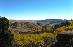
The Ravenscrag Formation reaches a maximum thickness of 244 metres (800 ft) and is present in southwestern Saskatchewan and the Cypress Hills area of southeastern Alberta. [1] [5]

Relationship to other units

Although some early workers included the underlying Frenchman Formation as the lower Ravenscrag, the two are separated by the Cretaceous-Paleogene boundary and are now treated separately. [9] The contact is abrupt but conformable, and occurs at the base of the lowermost coal seam (the No. 1 or Ferris coal seam) in the Ravenscrag Formation. [7] [8] [5]

The Ravenscrag Formation is unconformably overlain by the Eocene age Swift Current Formation, [9] and it is exposed at surface where younger formations have been removed by erosion. [2] It is equivalent in age to the upper part of the Scollard Formation and the lower part of the Paskapoo Formation in southern Alberta, and to the Fort Union Formation in Montana and North Dakota.

Paleontology

A cast of the skeleton of Borealosuchus displayed at the North Dakota Heritage Center & State Museum. Bones of this crocodilian have been found in the Ravenscrag Formation. Borealosuchus skeleton cast.jpg
A cast of the skeleton of Borealosuchus displayed at the North Dakota Heritage Center & State Museum. Bones of this crocodilian have been found in the Ravenscrag Formation.

The Ravenscrag Formation contains remains of vertebrates that provide important information about the dawn of the age of mammals after the Cretaceous-Paleogene extinction event. Material from the following groups of mammals has been reported: Multituberculata, Marsupicarnivora, Eulipotyphla, Dermoptera, Primates, Carnivora, Ungulata and Pantodonta. These occur primarily as isolated teeth, fragments of jaws with teeth, and isolated skeletal parts. They are associated with the remains of fish such as Amia and Lepisosteus , small reptiles and amphibians, and crocodilians [10] including Borealosuchus (originally Leidyosuchus) acutidentatus. [6]

The formation also contains a wide variety of plant fossils. Ferns include species of Osmunda , Onoclea , Azolla and others. Gymnosperms are represented by remains of Ginkgo and cupressaceous conifers such as Metasequoia and Glyptostrobus , and there are numerous types of leaves, seeds, flowers and other structures from angiosperms. [6] The fossil pollen assemblage has also been described. [11]

Economic geology

The coal seams of the Ravenscrag Formation are of lignitic rank and have a low sulphur content. They are mined at several locations in southern Saskatchewan to fuel mine-mouth electrical power stations. [4]

Clay has been produced from the Ravenscrag Formation and used primarily for the manufacture of various types of brick. [12] [13]

Related Research Articles

<span class="mw-page-title-main">Scollard Formation</span> Upper Cretaceous to lower Palaeocene stratigraphic unit of the Western Canada Sedimentary Basin

The Scollard Formation is an Upper Cretaceous to lower Palaeocene stratigraphic unit of the Western Canada Sedimentary Basin in southwestern Alberta. Its deposition spanned the time interval from latest Cretaceous to early Paleocene, and it includes sediments that were deposited before, during, and after the Cretaceous-Paleogene (K-Pg) extinction event. It is significant for its fossil record, and it includes the economically important coal deposits of the Ardley coal zone.

The Frenchman Formation is stratigraphic unit of Late Cretaceous age in the Western Canada Sedimentary Basin. It is present in southern Saskatchewan and the Cypress Hills of southeastern Alberta. The formation was defined by G.M. Furnival in 1942 from observations of outcrops along the Frenchman River, between Ravenscrag and Highway 37. It contains the youngest of dinosaur genera, much like the Hell Creek Formation in the United States.

The Willow Creek Formation is a stratigraphic unit of Late Cretaceous to Early Paleocene age in the Western Canada Sedimentary Basin of southwestern Alberta. It was first described by George Mercer Dawson in 1883 along the Willow Creek, a tributary of the Oldman River. Williams and Dyer defined the type section in 1930 at the mouth of Willow Creek, east of Fort Macleod.

<span class="mw-page-title-main">Cadomin Formation</span>

The Cadomin Formation is a stratigraphic unit of Early Cretaceous age in the western part of the Western Canada Sedimentary Basin. It is extends from southeastern British Columbia through western Alberta to northeastern British Columbia, and it contains significant reservoirs of natural gas in some areas. It was named after the mining town of Cadomin, which is an acronym of "Canadian Dominion Mining".

<span class="mw-page-title-main">Viking Formation</span>

The Viking Formation is a stratigraphical unit of Cretaceous age in the Western Canadian Sedimentary Basin.

<span class="mw-page-title-main">Paskapoo Formation</span> Stratigraphic unit in Western Canada

The Paskapoo Formation is a stratigraphic unit of Middle to Late Paleocene age in the Western Canada Sedimentary Basin. The Paskapoo underlies much of southwestern Alberta, and takes the name from the Blindman River. It was first described from outcrops along that river, near its confluence with the Red Deer River north of the city of Red Deer, by Joseph Tyrrell in 1887. It is important for its freshwater aquifers, its coal resources, and its fossil record, as well as having been the source of sandstone for the construction of fire-resistant buildings in Calgary during the early 1900s.

The Mist Mountain Formation is a geologic formation of latest Jurassic to earliest Cretaceous age in the Western Canada Sedimentary Basin that is present in the southern and central Canadian Rockies. It was named for outcrops along the western spur of Mist Mountain in Alberta by D.W. Gibson in 1979. The Mist Mountain Formation contains economically important coal seams that have been mined in southeastern British Columbia and southwestern Alberta.

<span class="mw-page-title-main">Elk Point Group</span>

The Elk Point Group is a stratigraphic unit of Early to Middle Devonian age in the Western Canada and Williston sedimentary basins. It underlies a large area that extends from the southern boundary of the Northwest Territories in Canada to North Dakota in the United States. It has been subdivided into numerous formations, number of which host major petroleum and natural gas reservoirs.

<span class="mw-page-title-main">Edmonton Group</span>

Within the earth science of geology, the Edmonton Group is a Late Cretaceous to early Paleocene stratigraphic unit of the Western Canada Sedimentary Basin in the central Alberta plains. It was first described as the Edmonton Formation by Joseph Burr Tyrrell in 1887 based on outcrops along the North Saskatchewan River in and near the city of Edmonton. E.J.W. Irish later elevated the formation to group status and it was subdivided into four separate formations. In ascending order, they are the Horseshoe Canyon, Whitemud, Battle and Scollard Formations. The Cretaceous-Paleogene boundary occurs within the Scollard Formation, based on dinosaurian and microfloral evidence, as well as the presence of the terminal Cretaceous iridium anomaly.

The Porcupine Hills Formation is a stratigraphic unit of middle to late Paleocene age in the Western Canada Sedimentary Basin. It takes its name from the Porcupine Hills of southwestern Alberta, and was first described in outcrop by George Mercer Dawson in 1883.

<span class="mw-page-title-main">Morrissey Formation</span>

The Morrissey Formation is a stratigraphic unit of Late Jurassic (Portlandian) age in the Western Canada Sedimentary Basin. It is named for outcrops on Morrissey Ridge, 16 kilometres (10 mi) southeast of Fernie, British Columbia, and is present in southeastern British Columbia and southwestern Alberta.

The Elk Formation is a stratigraphic unit of the Western Canada Sedimentary Basin that is present in southeastern British Columbia and southwestern Alberta. It is probably of Early Cretaceous age, but in some areas its strata could be as old as Late Jurassic. It includes minor thin coal beds and was named for outcrops near the now-abandoned Elk River coal mine east of Fernie, British Columbia.

The Coalspur Formation is an Upper Cretaceous to lower Palaeocene stratigraphic unit of the Western Canada Sedimentary Basin in the foothills of southwestern Alberta. Its deposition spanned the time interval from latest Cretaceous (Maastrichtian) to early Palaeocene, and it includes sediments that were deposited before, during, and after the Cretaceous-Paleogene (K-Pg) extinction event. It includes the economically important coal deposits of the Coalspur Coal Zone, as well as nonmarine plant and animal fossils.

The Monteith Formation is a geologic formation of Early Cretaceous (Valanginian) age in the Western Canada Sedimentary Basin that consists primarily of sandstone. It is present in the northern foothills of the Canadian Rockies and the adjacent plains in northeastern British Columbia and west-central Alberta.

The Battle Formation is a geologic formation of Late Cretaceous (Maastrichtian) age in the Western Canada Sedimentary Basin. It is present throughout much of the central Alberta plains, where it is an important stratigraphic marker in the nonmarine Upper Cretaceous sequence. It was formally named by G.M. Furnival in 1942 and given formation status by E.J.W. Irish in 1970.

The Whitemud Formation is a geologic formation of Late Cretaceous (Maastrichtian) age in the Western Canada Sedimentary Basin. it is present through the plains of southern Saskatchewan, southeastern Alberta and south-central Alberta. Named by N.B. Davis in 1918, the formation is characterized by white kaolinitic clay and is a source of high-quality refractory clay. The type locality has been designated as Dempster's clay pit northwest of Eastend, Saskatchewan.

The Kootenay Group, originally called the Kootenay Formation, is a geologic unit of latest Jurassic to earliest Cretaceous age in the Western Canada Sedimentary Basin that is present in the southern and central Canadian Rockies and foothills. It includes economically important deposits of high-rank bituminous and semi-anthracite coal, as well as plant fossils and dinosaur trackways.

The Bickford Formation is a geologic formation of Early Cretaceous (Valanginian) age in the Western Canada Sedimentary Basin that consists primarily of nonmarine sediments. It is present in the northern foothills of the Canadian Rockies in northeastern British Columbia.

The Luscar Group is a geologic unit of Early Cretaceous age in the Western Canada Sedimentary Basin that is present in the foothills of southwestern Alberta. It is subdivided into a series of formations, some of which contain economically significant coal deposits that have been mined near Cadomin and Luscar. Coal mining in those areas began in the early 1900s and continues near Luscar as of 2016.

The Gladstone Formation is a stratigraphic unit of Early Cretaceous (Aptian) age in the Western Canada Sedimentary Basin. It is present in the foothills of southwestern Alberta and is named for outcrops along Gladstone Creek, a tributary of the Castle River south of the Crowsnest Pass.

References

  1. 1 2 3 Lexicon of Canadian Geologic Units. "Ravenscrag Formation" . Retrieved 2010-01-01.
  2. 1 2 Mossop, G.D. and Shetsen, I., (compilers), Canadian Society of Petroleum Geologists and Alberta Geological Survey (1994). "The Geological Atlas of the Western Canada Sedimentary Basin, Chapter 24: Upper Cretaceous and Tertiary strata of the Western Canada Sedimentary Basin". Archived from the original on 2013-07-21. Retrieved 2013-08-01.{{cite web}}: CS1 maint: multiple names: authors list (link)
  3. 1 2 Davis, N.B., 1918. Report on the clay resources of southern Saskatchewan; Canada, Department of Mines, Mines Branch, Report 468, 93 p.
  4. 1 2 3 Mossop, G.D. and Shetsen, I., (compilers), Canadian Society of Petroleum Geologists (1994). "The Geological Atlas of the Western Canada Sedimentary Basin, Chapter 33: Coal Resources of the Western Canada Sedimentary Basin". Archived from the original on 2013-09-30. Retrieved 2013-08-01.{{cite web}}: CS1 maint: multiple names: authors list (link)
  5. 1 2 3 Glass, D.J., editor, 1997. Lexicon of Canadian Stratigraphy, vol. 4, Western Canada, p. 974. Canadian Society of Petroleum Geologists, Calgary, Alberta, 1423 p. on CD-ROM, ISBN   0-920230-23-7.
  6. 1 2 3 4 McIver, E.E. and Basinger, J.F. 1993. Flora of the Ravenscrag Formation (Paleocene), southwestern Saskatchewan, Canada. Palaeontographica Canadiana No. 10, 167 p. Geological Association of Canada and Canadian Society of Petroleum Geologists.
  7. 1 2 Lerbekmo, J.F. 1985. Magnetostratigraphic and biostratigraphic correlations of Maastrichtian to early Paleocene strata between south-central Alberta and southwestern Saskatchewan. Bulletin of Canadian Petroleum Geology, vol. 33, p. 213-226.
  8. 1 2 Lerbekmo, J.F., Sweet, A.R. and St. Louis, R.M. 1987. The relationship between the iridium anomaly and palynofloral events at three Cretaceous-Tertiary boundary localities in western Canada. Geological Society of America Bulletin, 99:25-330.
  9. 1 2 "Saskatchewan Stratigraphic Correlation Chart" . Retrieved 14 September 2020.
  10. Fox, R.C., 1990. The succession of Paleocene mammals in western Canada. Geological Society of America, Special Paper 243, pp. 51-70.
  11. Sweet, A.R. 1978. Palynology of the Ravenscrag and Frenchman formations. In: Whitaker, S.H. et al. (eds), Coal resources of southern Saskatchewan: a model for evaluation methodology. Geological Survey of Canada, Economic Geology Report 30, p. 29-38.
  12. Worcester, W.G. (1950). "Clay resources of Saskatchewan". Province of Saskatchewan, Dept. of Natural Resources, Technical and Economic Series Report No. 2, 199 p. Retrieved 2013-11-04.
  13. Lindoe, L.O. 1965. Ceramic clays of the Cypress Hills. Alberta Society of Petroleum Geologists, 15th Annual Field Trip Guidebook, Part 1, Cypress Hills plateau, p. 210-225.