
Carrollton is a town in Cattaraugus County, New York, United States. The population was 1,214 at the 2020 census. The town was named after Guy Carrollton Irvine, an early settler of the region.

Elma is a town in Erie County, New York, United States. The population was 11,721 at the 2020 census. The town is named after the American elm tree.

Grand Island is an island town in Erie County, New York, United States. As of the 2020 census, the town's population was 21,389 representing an increase of 5.00% from the 2010 census figure. The town's name is derived from the French name La Grande Île; Grand Island is the largest island in the Niagara River and the third largest in New York state. The phrase La Grande Île appears on the town seal.
Clay is a town in Onondaga County, New York, United States. As of the 2020 Census, the population was 60,527, making it Syracuse's most populous suburb. The town was named after American attorney and statesman Henry Clay.

Lysander is a town in Onondaga County, New York, United States. As of the 2020 Census, the population was 23,074. The town was named after Lysander, a Spartan military leader, by a clerk interested in the classics. Lying to the northwest of Syracuse, much of the town is suburban in character.

Wilton is a town in Saratoga County, New York, United States. The population was 17,361 at the 2020 census.
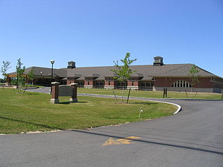
Fayette is a town in Seneca County, New York, United States. The population was 3,617 at the 2020 census. The town is in the north-central part of the county and is southeast of Geneva, New York.
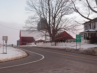
Tyre is a town in Seneca County, New York, United States. The population was 1,002 at the 2020 census. The town is named after the Lebanese city of Tyre.
Salamanca is a town in Cattaraugus County, New York, United States. The population was 470 at the 2020 census. The name is from José de Salamanca y Mayol, Marquis of Salamanca, a major Spanish investor in the Atlantic and Great Western Railroad, a local railroad.

West Seneca is a town in Erie County, New York, United States. The population was 45,500 at the 2020 census. West Seneca is a centrally located interior town of the county, and a suburb of Buffalo. West Seneca, Orchard Park and Hamburg form the inner "Southtowns", a cluster of middle-class suburban towns.

Caledonia is a town in Livingston County, New York, United States. The population was 4,154 at the 2020 census. The town contains the village of Caledonia. The town is in the northwestern part of the county and is southwest of Rochester. It is part of the Rochester metropolitan area.
Nunda is a town in Livingston County, New York, United States. The population was 3,064 at the 2010 census. Nunda welcomes visitors with signs stating "Welcome to Nunda, a Nice Place to Live." The name is derived from Nunda-wa-ono, the name given to it by a group of the Seneca people who once lived in the hills and valleys along the Genesee River and Keshequa Creek within the present-day town. In the Seneca language, "Nunda" relates to hills, and a popular translation is "Where the valley meets the hills".

Elbridge is a town in Onondaga County, New York, United States. As of the 2020 Census, the population was 5,476. The town is named after Elbridge Gerry, the fifth Vice President of the United States, and one of the signers of the Declaration of Independence.

Seneca Falls is a hamlet and census-designated place in Seneca County, New York, United States. The population was 6,681 at the 2010 census. The 2020 census population of Seneca Falls CDP was 6,809. The hamlet is in the Town of Seneca Falls, east of Geneva. It was an incorporated village from 1831 to 2011.
Seneca Falls is a town in Seneca County, New York, United States. The population was 9,027 at the 2020 census.

New York State Route 48 (NY 48) is a 28.20-mile (45.38 km) north–south state highway in Central New York in the United States. The southern terminus of the route is located at Interstate 690 (I-690) exit 3 near the interchange between I-690 and the New York State Thruway (I-90) in Van Buren, northwest of Syracuse. The northern terminus is located at an intersection with NY 104 in Oswego. In between, NY 48 passes through the riverside communities of Baldwinsville and Fulton and runs alongside both the Seneca River and Oswego River. For most of its route, NY 48 serves as an alternate route of NY 481. The routes share similar alignments along the Oswego River from the Syracuse area to Oswego, with NY 481 following the eastern riverbank between the two locations.

Memphis is a hamlet in the Town of Van Buren, west of Syracuse in Onondaga County, New York, United States.

New York State Route 414 (NY 414) is a north–south state highway in the Southern Tier and Finger Lakes regions of New York in the United States. It extends for 83.20 miles (133.90 km) from an intersection with NY 352 in the Steuben County city of Corning to a junction with NY 104 in the Wayne County town of Huron. NY 414 spans five counties and roughly parallels NY 14 between Watkins Glen and Huron. It intersects every major east–west arterial in western New York, including the Southern Tier Expressway, U.S. Route 20 (US 20) and NY 5, and the New York State Thruway (I-90). The route passes through mostly rural areas as it travels between the several villages and cities along its routing.

New York State Route 89 (NY 89) is a north–south state highway in central New York in the United States. It extends for 62.35 miles (100.34 km) from an intersection with NY 13, NY 34, and NY 96 in the Tompkins County city of Ithaca to an interchange with NY 104 in the Wayne County town of Wolcott. The route spans a total of three counties, connecting the heart of the Finger Lakes Region to a point 6 miles (10 km) south of Lake Ontario. Along the way, NY 89 intersects two regionally important highways: the conjoined routes of U.S. Route 20 (US 20) and NY 5 in Seneca Falls and NY 31 in Savannah. NY 89 runs along the western edge of Cayuga Lake from Ithaca to Seneca Falls.

The Clyde River is a main tributary which feeds the Seneca River in Seneca County, New York, United States. It begins at the hamlet of Lyons in nearby Wayne County and meanders for approximately 27 miles from west to east before emptying into the Seneca River in the town of Tyre at Montezuma National Wildlife Refuge. Much of the original river has been channeled through to form part of the Erie Canal. A number of tributaries feed the Clyde River along its route.

