
McClain County is a county located in south central Oklahoma. As of the 2020 census, the population was 41,662. Its county seat is Purcell. The county was named for Charles M. McClain, an Oklahoma constitutional convention attendee.

Cleveland County is a county in the central part of the U.S. state of Oklahoma. The population was 295,528 at the 2020 United States census, making it the third-most populous county in Oklahoma. Its county seat is Norman. The county was named for U.S. President Grover Cleveland. Cleveland County is part of the Oklahoma City metropolitan statistical area.
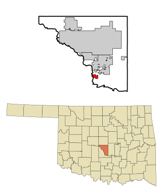
Lexington is a city in Cleveland County, Oklahoma, United States. The city population was 2,010 at the 2020 census, a 6.6% decrease from 2010.

Purcell is a city in and the county seat of McClain County, Oklahoma, United States. As of the 2020 census, the city population was 6,651, a 13% increase from 2010.

U.S. Route 412 is an east–west United States highway, first commissioned in 1982. U.S. 412 overlaps expressway-grade Cimarron Turnpike from Tulsa west to Interstate 35 and the Cherokee Turnpike from 5 miles (8.0 km) east of Chouteau, Oklahoma, to 8 miles (13 km) west of the Arkansas state line. It runs the entire length of the Oklahoma Panhandle and traverses the Missouri Bootheel.

U.S. Route 378 (US 378) is a spur of US 78 in the U.S. states of Georgia and South Carolina. The U.S. Highway runs 234.30 miles (377.07 km) from US 78, Georgia State Route 10 (SR 10), SR 17, and SR 47 in Washington, Georgia, east to US 501 Business in Conway, South Carolina. US 378 connects the Central Savannah River Area in both states with the Midlands and Pee Dee regions of South Carolina. The U.S. Highway's western portion, which connects Washington and Lincolnton in Georgia and McCormick, Saluda, and Lexington in South Carolina, is mainly a rural highway. US 378 is a major suburban and urban highway through Lexington and South Carolina's state capital, Columbia. The highway has a lengthy concurrency with US 76 between Columbia and Sumter and serves as a major route between the Midlands and the Myrtle Beach area, between which the highway has a business route through Lake City.

State Highway 74, usually abbreviated as SH-74 or OK-74 is the numbering of two different highways maintained by the U.S. state of Oklahoma. These highways were once a single major north–south route, connecting Oklahoma City to more rural parts of the state. The original road stretched from SH-7 near Tatums to SH-11 west of Deer Creek.
State Highway 9, abbreviated as SH-9, OK-9, or simply Highway 9, is a major east–west highway in the U.S. state of Oklahoma. Spanning across the central part of the state, SH-9 begins at the Texas state line west of Vinson, Oklahoma, and ends at the Arkansas state line near Fort Smith, Arkansas. State Highway 9 is a major highway around the Norman area. At 348.1 miles (560.2 km), SH-9 is Oklahoma's second-longest state highway.

State Highway 39, abbreviated as SH-39, is a state highway in the U.S. state of Oklahoma. It is 68.4 miles (110.1 km) in length. It runs east–west through the central part of the state, beginning at unincorporated Tabler, east of Chickasha, and ending east of Konawa. Along the way, SH-39 serves the counties of Grady, McClain, Cleveland, Pottawatomie, and Seminole. It currently has no lettered spurs.
State Highway 145, abbreviated as SH-145 or OK-145, is a short, 2.88 miles (4.63 km) highway in Garvin County, Oklahoma. It connects Interstate 35 at its west end to US-77 in Paoli at its east end. It does not have any spur routes.

The Oklahoma City metropolitan area is an urban region in Central Oklahoma. It is the largest metropolitan area in the state of Oklahoma and contains the state capital and principal city, Oklahoma City. It is often known as the Oklahoma City Metro, Oklahoma City Metroplex, or Greater Oklahoma City in addition to the nicknames Oklahoma City itself is known for, such as OKC or "the 405".
Interstate 85 (I-85) is a part of the Interstate Highway System that runs 666.05 miles (1,071.90 km) from Montgomery, Alabama, to Petersburg, Virginia. In the U.S. state of North Carolina, I-85 crosses the entire state from southwest to northeast, at the South Carolina state line near Grover to the Virginia state line near Wise. Running for over 231.23 miles (372.13 km), the segment of I-85 is the longest of the five states it passes through and the second-longest Interstate Highway in North Carolina after I-40.
Interstate 35 (I-35), in the US State of Oklahoma, runs from the Red River at the Texas border to the Kansas state line near Braman for a length of 236 miles (380 km). I-35 has one auxiliary route in the state, I-235, in the inner city of Oklahoma City. A second auxiliary route, I-335, is the designation for the Kickapoo Turnpike, although it will not meet I-35 until the southern extension of the turnpike to a junction with I-35 in Purcell is built. Excluding the Panhandle, I-35 forms the informal bisector for central Oklahoma, and along with US 81/US 283 in western Oklahoma and US 69/US 75 in the eastern portion, it provides one of the main north-south corridors through the state.

U.S. Highway 77 (US-77) in Oklahoma is a 267.21-mile-long (430.03 km) U.S. Highway in the U.S. state of Oklahoma. It travels from south to north, paralleling Interstate 35 (I-35), connecting Texas to Kansas through the central part of the state. It travels through many major cities, including Ardmore, Oklahoma City and its suburbs, Guthrie, and Ponca City. It has four lettered spur routes.
Interstate 90 (I-90) runs east–west across the northern tier of the US state of Ohio. Much of it is along the Ohio Turnpike, but sections outside the turnpike pass through Cleveland and northeast into Pennsylvania.

Interstate 75 (I-75) is a part of the Interstate Highway System that runs 1,786.47 miles (2,875.04 km) from Miami Lakes, Florida to the Canada–United States border at Sault Ste. Marie, Michigan. In the U.S. state of Kentucky, I-75 runs through the eastern half of the state, from the Tennessee state line near the city of Williamsburg to the Ohio state line near Covington. The Interstate serves the state's second-most populous city, Lexington. Outside of it, the route is mostly rural or suburban in nature, mainly providing access to other cities via state and U.S. Highways. The major landscapes traversed by I-75 include the rolling hills and mountains of the Cumberland Plateau, the flat Bluegrass region, the urban core of Lexington, and the highly urbanized suburbs of Northern Kentucky; it also very briefly crosses through the Eastern Kentucky Coalfield at its southernmost stretch and passes near the Daniel Boone National Forest in London.

James Clark "Jim" Nance was a leader for 40 years in the Oklahoma Legislature in the U.S. state of Oklahoma and was community newspaper chain publisher 66 years. Nance served as Speaker of the Oklahoma House of Representatives and President pro tempore of the Oklahoma Senate. During his legislative career, Nance wrote the "Honest Mistake" law which became a model for other states. Nance then became a key sponsor and Legislative Chairman of the U.S. Uniform Law Commission (ULC), sponsored by the National Conference of Commissioners on Uniform State Laws, a non-partisan advisory panel which drafted uniform acts and uniform state commerce laws. Nance became known as a legislative expert in a 40-year legislative career as one of two Oklahomans to hold the top posts in both chambers of the Oklahoma Legislature. The state's largest newspaper, The Daily Oklahoman wrote he was the "longest serving Oklahoma Legislator" and "A Legislator's Legislator." Nance, a Democrat, is the only Oklahoma House Speaker elected through a bipartisan coalition of Democrats and Republicans. Fiercely independent, Nance considered public policy work to be a service and did not ever accept a salary or pension for any of his 40 years in the legislature and 24 years on the Uniform Law Commission. Nance refused to work as a lobbyist, although he had many offers after leaving office.

US Highway 41 (US 41) is a part of the United States Numbered Highway System that runs from Miami, Florida, to the Upper Peninsula of the US state of Michigan. In Michigan, it is a state trunkline highway that enters the state via the Interstate Bridge between Marinette, Wisconsin, and Menominee, Michigan. The 278.769 miles (448.635 km) of US 41 that lie within Michigan serve as a major conduit. Most of the highway is listed on the National Highway System. Various sections are rural two-lane highway, urbanized four-lane divided expressway and the Copper Country Trail National Scenic Byway. The northernmost community along the highway is Copper Harbor at the tip of the Keweenaw Peninsula. The trunkline ends at a cul-de-sac east of Fort Wilkins State Park after serving the Central Upper Peninsula and Copper Country regions of Michigan.

U.S. Route 52 (US 52) is a north–south United States highway that runs for 150 miles (240 km) from the South Carolina state line, near McFarlan, to the Virginia state line, near Mount Airy. It serves as a strategic highway through the central North Carolina Piedmont. Because of its alignment in the state, US 52 does not follow the standard convention of an even U.S. route number going east–west.
The James E. Roberts Memorial Bridge is a 1,400 foot two-lane highway bridge along the California State Route 120/California State Route 49 concurrency, in Tuolumne County, California. The bridge spans the Tuolumne River just north of Lake Don Pedro, near the community of Chinese Camp. It opened in 1971.


