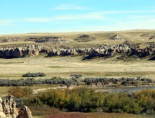
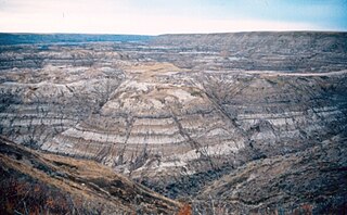
The Foremost Formation is a stratigraphic unit of Late Cretaceous (Campanian) age that underlies much of southern Alberta, Canada. It was named for outcrops in Chin Coulee near the town of Foremost and is known primarily for its dinosaur remains and other fossils.
Bullhead Group is a stratigraphic unit of Lower Cretaceous age in the Western Canada Sedimentary Basin of northeastern British Columbia and western Alberta. It was first defined by F.H. McLearn in 1918 as the Bullhead Mountain Formation, but later was upgraded to group status. It consists of the Cadomin and Gething Formations, although some early workers included the Bluesky Formation and others in the group.

The Spirit River Formation is a stratigraphical unit of middle Albian age in the Western Canadian Sedimentary Basin.

The Peace River Formation is a stratigraphical unit of middle Albian age in the Western Canadian Sedimentary Basin.
The Dunvegan Formation is a stratigraphical unit of Cenomanian age in the Western Canadian Sedimentary Basin.
The Clearwater Formation is a stratigraphic unit of Early Cretaceous (Albian) age in the Western Canada Sedimentary Basin in northeastern Alberta, Canada. It was first defined by R.G. McConnell in 1893 and takes its name from the Clearwater River near Fort McMurray.
The Mannville Group is a stratigraphical unit of Cretaceous age in the Western Canadian Sedimentary Basin.
The Viking Formation is a stratigraphical unit of Cretaceous age in the Western Canadian Sedimentary Basin.

The Muskiki Formation is a stratigraphical unit of Late Cretaceous age in the Western Canadian Sedimentary Basin.

The Paskapoo Formation is a stratigraphic unit of Middle to Late Paleocene age in the Western Canada Sedimentary Basin. The Paskapoo underlies much of southwestern Alberta, and takes the name from the Blindman River. It was first described from outcrops along that river, near its confluence with the Red Deer River north of the city of Red Deer, by Joseph Tyrrell in 1887. It is important for its freshwater aquifers, its coal resources, and its fossil record, as well as having been the source of sandstone for the construction of fire-resistant buildings in Calgary during the early 1900s.
The Enon Formation is a geological formation found in the Eastern and Western Cape provinces in South Africa. It is the lowermost of the four formations found within the Uitenhage Group of the Algoa Basin, its type locality, where it has been measured at a maximum thickness of 480 metres (1,570 ft). Discontinuous outcrops are also found in the Worcester-Pletmos and Oudshoorn-Gamtoos Basins, including isolated occurrences in the Haasvlakte, Jubilee, and Soutpansvlakte Basins near the small town Bredasdorp.
The Elk Point Group is a stratigraphic unit of Early to Middle Devonian age in the Western Canada and Williston sedimentary basins. It underlies a large area that extends from the southern boundary of the Northwest Territories in Canada to North Dakota in the United States. It has been subdivided into numerous formations, number of which host major petroleum and natural gas reservoirs.
Within the earth science of geology, the Edmonton Group is a Late Cretaceous to early Paleocene stratigraphic unit of the Western Canada Sedimentary Basin in the central Alberta plains. It was first described as the Edmonton Formation by Joseph Burr Tyrrell in 1887 based on outcrops along the North Saskatchewan River in and near the city of Edmonton. E.J.W. Irish later elevated the formation to group status and it was subdivided into four separate formations. In ascending order, they are the Horseshoe Canyon, Whitemud, Battle and Scollard Formations. The Cretaceous-Paleogene boundary occurs within the Scollard Formation, based on dinosaurian and microfloral evidence, as well as the presence of the terminal Cretaceous iridium anomaly.
The Labiche Formation is a stratigraphical unit of late Albian to Santonian age in the Western Canadian Sedimentary Basin.

The Morrissey Formation is a stratigraphic unit of Late Jurassic (Portlandian) age in the Western Canada Sedimentary Basin. It is named for outcrops on Morrissey Ridge, 16 kilometres (10 mi) southeast of Fernie, British Columbia, and is present in southeastern British Columbia and southwestern Alberta.
The Hulcross Formation is a geologic formation in the Western Canada Sedimentary Basin in northeastern British Columbia that was deposited in marine environments during the late Albian stage of the Early Cretaceous period. At one time considered to be a member of the Commotion Formation, it was elevated to formation status by D.F. Stott in 1982. It preserves ammonites and other fossils.
The Luscar Group is a geologic unit of Early Cretaceous age in the Western Canada Sedimentary Basin that is present in the foothills of southwestern Alberta. It is subdivided into a series of formations, some of which contain economically significant coal deposits that have been mined near Cadomin and Luscar. Coal mining in those areas began in the early 1900s and continues near Luscar as of 2016.
The Gladstone Formation is a stratigraphic unit of Early Cretaceous (Aptian) age in the Western Canada Sedimentary Basin. It is present in the foothills of southwestern Alberta and is named for outcrops along Gladstone Creek, a tributary of the Castle River south of the Crowsnest Pass.
The La Loche Formation is a geologic formation of early Middle Devonian (Eifelian) age in the Western Canada Sedimentary Basin. It is present in northeastern Alberta and northwestern Saskatchewan and was first described by A. W. Norris in 1963, who named it for a Roman Catholic Mission at Lac La Loche. Its type section is located at Contact Rapids on the Clearwater River in Saskatchewan, northwest of Lac La Loche. It is not fossiliferous.
The geology of Alberta encompasses parts of the Canadian Rockies and thick sedimentary sequences, bearing coal, oil and natural gas, atop complex Precambrian crystalline basement rock.