Kalmiuske

Last updated
Kalmiuske (Komsomolske)
Ukrainian: Кальміуське
Russian: Кальмиусское (Комсомольское)
Kalmiuske
Koms 5 school.jpeg
School #5 in Kalmiuske
Flag-koms.tif
Gerb koms.jpg
Donetsk Oblast location map.svg
Red pog.svg
Kalmiuske (Komsomolske)
Ukraine under russian occupation grey.svg
Red pog.svg
Kalmiuske (Komsomolske)
Coordinates: 47°40′N38°04′E / 47.667°N 38.067°E / 47.667; 38.067
Country Flag of Ukraine.svg  Ukraine
Oblast Donetsk Oblast
Raion Kalmiuske Raion
Hromada Kalmiuske urban hromada
Founded1933
City status1956
Area
  Total119 km2 (46 sq mi)
Elevation
72 m (236 ft)
Population
 (2022)
  Total11,422

Kalmiuske [lower-alpha 1] or Komsomolske [lower-alpha 2] is a city in Donetsk Oblast (province), Ukraine. It is a limestone mining city, located on the Kalmius river of eastern Ukraine. It has a population of 11,422 (2022 estimate). [1]

Contents

Geography

Kalmiuske is located on the Kalmius river that flows into the Azov Sea. [2] It is 42 kilometres (26 mi) southwest of Donetsk, the center of Donetsk Oblast. [3]

History

19th and 20th century

Limestone deposits were first discovered in the Kalmius River Valley near the village Karakuba (now Rozdolne, Kalmiuske Raion, Donetsk Oblast  [ uk ]) in 1833. Further research was conducted by other geologists that was eventually published in 1909 that showed significant deposits of a type of limestone required for metallurgy. [2] [4] However, actual development of the area did not begin until after the establishment of the Soviet Union on much of the former territory of the Russian Empire. In 1930, Soviet scientists organized an extensive survey of the "Karakuba" limestone area. The construction of the actual mines that would extract the limestone began three years later in 1933. [4]

Kalmiuske was founded in 1933 as the village of Karakubbud [lower-alpha 3] in connection with the construction of limestone mines nearby. It was located in Starobesheve Raion, then one of the raions in Donetsk Oblast of the Ukrainian Soviet Socialist Republic. In 1933–34, the first hundred thousand tons of limestone were obtained. By 1939, Karakubbud had a population of around 5,500 people. During World War II, Karakubbud was occupied by Nazi Germany from October 1941 to September 1943. The Nazis operated a prisoner of war camp near the outskirts of the village Chkalovske (which has since been absorbed into Kalmiuske as a district) where they killed about 6,600 people. After the end of the war, a monument was erected at the site of the prison in memory to the victims. [2]

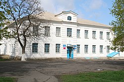
Karakubbud was renamed Komsomolske in 1949, and was granted city status in 1956. [2] In 1971, the population was 15,800 people, flux limestone was mined here. Also, food industry enterprises and an industrial technical school were here. [5]

By the time of the 1989 Soviet census, the population of the city was around 14,100 people. [2] The basis of the economy continued to be limestone mining. [6] In 1997, the vocational school No. 68 located in the city was merged with vocational school No. 79. [7]

21st century

Donetsk People's Republic militants in Komsomolske, September 2014 Motorola in Komsomolske (cropped screenshot).jpg
Donetsk People's Republic militants in Komsomolske, September 2014

Starting in mid-April 2014, pro-Russian separatists captured several towns in Donetsk Oblast, [8] including Komsomolske. On 29 August 2014, Ukrainian forces reportedly secured the city from the separatists. [9] However, after the separatist victory at the battle of Ilovaisk, the separatists loyal to the self-proclaimed Donetsk People's Republic (DPR), accompanied by the Russian military, entered Komsomolske. [10] On 31 August, Komsomolske was confirmed to have been fully recaptured by the separatists. [11] Reportedly, Arsen "Motorola" Pavlov personally hung up the flag of the Donetsk People's Republic all over the city, and Komsomolske became essentially a closed city. The Kharkiv Human Rights Group reported that the DPR authorities abused the "terrified" population, and arrested and tortured numerous people in the city for having pro-Ukrainian views. [10]

During the Minsk agreements of 2014–2015 that theoretically aimed to de-escalate the war, Komsomolske was designated as part of a zone in which "deployment of heavy armaments and military equipment" was banned. [12]

In May 2016, the Verkhovna Rada renamed the city from Komsomolske to Kalmiuske in accordance with decommunization laws. [13] However, since the city has not been under control of the Ukrainian government, the residents remaining in the city were mostly unaware of the name change as of September that same year. Radio Svoboda, interviewing ten residents of the city in September, reported that only one had heard about the renaming law. Some legal documents still used "Komsomolske" at the time, though the newspaper predicted that after a few years, this would be rectified. [14]

In mid-2017, there were a number of spurious arrests of people in the city by the separatists, intensifying the atmosphere of fear. Dozens have been convicted of "collaborating with the SBU" and sentenced to many years in the Izolyatsia prison as well as jails in Makiivka. [10] In late 2017, the separatists repeatedly violated the terms of the Minsk agreements banning the deployment of heavy equipment in Kalmiuske. On 8 September 2017, the OSCE mission in Ukraine reported "eight military-type armoured vehicles and almost 60 military-type trucks" had been deployed by rebels in the city, [3] and 10 October 2017, they reported the rebels had deployed four surface-to-air missile systems in Kalmiuske. [12]

In June 2020, as part of the nationwide reform of administrative divisions of Ukraine, Kalmiuske was designated the administrative center of Kalmiuske urban hromada, a hromada of Ukraine that also contained several other villages and rural settlements. [15] In July the same year, Starobesheve Raion was abolished, and Kalmiuske was transferred to and made the administrative center of the newly created Kalmiuske Raion. [16]

Demographics

Population history
YearPop.±%
1939 5,500 [2]     
1959 15,400 [2] +180.0%
1979 14,700 [2] −4.5%
1989 14,100 [2] −4.1%
YearPop.±%
2001 12,813 [2] −9.1%
2013 11,763 [17] −8.2%
2022 11,422 [1] −2.9%

In 2001, the city had a population of 12,813 people, most of whom were ethnic Ukrainians. [2]

Ethnic groups in Kalmiuske
Ethnic groupspercent
Ukrainians
57.24%
Russians
35.92%
Greeks
4.47%
Belarusians
0.61%
Azerbaijanis
0.37%
Armenians
0.21%
Georgians
0.17%
Tatars
0.17%
Moldovans
0.09%

[18]

Economy

Transport

Kalmiuske has a railway station. [5]

Notable people

Notes

  1. Ukrainian: Кальміуське; Russian: Кальмиусское
  2. Ukrainian: Комсомо́льське; Russian: Комсомольское
  3. Ukrainian: Каракуббуд; Russian: Каракубстрой, romanized: Karakubstroy

Related Research Articles

<span class="mw-page-title-main">Kadiivka</span> City in Luhansk Oblast, Ukraine

Kadiivka or Stakhanov, is a city in Alchevsk Raion, Luhansk Oblast, Donbas, eastern Ukraine. It is located on the Komyshuvakha River, a right tributary of the Luhan. Ukraine renamed the city Kadiivka in 2016, and refers to the city by this name, however Ukraine has not controlled the city since early 2014.

Shakhtarsk or Shakhtyorsk is a city in Horlivka Raion, Donetsk Oblast, eastern Ukraine, currently occupied by Russia. Regionally, the city is the administrative center of the Shakhtarsk urban hromada. Population: 48,208.

<span class="mw-page-title-main">Borshchiv</span> City in Ternopil Oblast, Ukraine

Borshchiv is a city in Chortkiv Raion, Ternopil Oblast, western Ukraine. It was previously the administrative center of the former Borshchiv Raion until 2020. Borshchiv hosts the administration of Borshchiv urban hromada, one of the hromadas of Ukraine. In 2022, the population was estimated to be 10,632.

<span class="mw-page-title-main">Novomyrhorod</span> City in Kirovohrad Oblast, Ukraine

Novomyrhorod is a city in Novoukrainka Raion, Kirovohrad Oblast, central Ukraine, in the southern part of the Middle Dnieper area. It hosts the administration of Novomyrhorod urban hromada, one of the hromadas of Ukraine. The population of Novomyrhorod is approximately 10,715.

<span class="mw-page-title-main">Prymorsk</span> City in Zaporizhzhia Oblast, Ukraine

Prymorsk is a city in Zaporizhzhia Oblast, Ukraine. It serves as the administrative center of Prymorsk urban hromada in Berdiansk Raion. Population: 11,157.

Hlobyne is a city in Kremenchuk Raion, Poltava Oblast, Ukraine. It hosts the administration of Hlobyne urban hromada, one of the hromadas of Ukraine. Population: 8,955.

Zastavna is a small city in Chernivtsi Raion, Chernivtsi Oblast of Ukraine. Zastavna is located 26 kilometres (16 mi) to the north of the city of Chernivtsi, in the historical region of Bukovina. It hosts the administration of Zastavna urban hromada, one of the hromadas of Ukraine. Population: 7,750.

<span class="mw-page-title-main">Haivoron</span> City in Kirovohrad Oblast, Ukraine

Haivoron is a city in Holovanivsk Raion, Kirovohrad Oblast, Ukraine. It hosts the administration of Haivoron urban hromada, one of the hromadas of Ukraine. Population: 14,010.

Kaharlyk is a small city in Kyiv Oblast (province) of Ukraine, located in Obukhiv Raion. Kaharlyk hosts the administration of Kaharlyk urban hromada, one of the hromadas of Ukraine. Population: 13,133.

<span class="mw-page-title-main">Bobrynets</span> City in Kirovohrad Oblast, Ukraine

Bobrynets is a city in Kropyvnytskyi Raion, Kirovohrad Oblast, Ukraine. It hosts the administration of Bobrynets urban hromada, one of the hromadas of Ukraine. Population: 10,396.

<span class="mw-page-title-main">Zolochiv, Kharkiv Oblast</span> Rural locality in Kharkiv Oblast, Ukraine

Zolochiv is a rural settlement in Bohodukhiv Raion, Kharkiv Oblast, Ukraine. It hosts the administration of Zolochiv settlement hromada, one of the hromadas of Ukraine. Population: 7,744.

Kozliv is an urban-type settlement in Ternopil Raion, Ternopil Oblast, western Ukraine. It hosts the administration of Kozliv settlement hromada, one of the hromadas of Ukraine. Population: 1,758.

<span class="mw-page-title-main">Boikivske Raion</span> Former subdivision of Donetsk Oblast, Ukraine, in use by the Donetsk Peoples Republic

Boikivske Raion or Telmanove Raion was one of the administrative raions of Donetsk Oblast, Ukraine from 1934 until 2020. The administrative center of the raion was located in the urban-type settlement of Boikivske, also known as Telmanove. The last estimate of the raion population, reported by the Ukrainian government, was 13,773.

<span class="mw-page-title-main">Yasynuvata Raion</span> Former subdivision of Donetsk Oblast, Ukraine, in use by the Donetsk Peoples Republic

Yasynuvata Raion was one of the administrative raions of Donetsk Oblast, located in southeastern Ukraine. The administrative center of the district was the city of Yasynuvata, which was incorporated separately as a city of oblast significance and did not belong to the districts jurisdiction.

<span class="mw-page-title-main">Starobesheve</span> Urban locality in Donetsk Oblast, Ukraine

Starobesheve is a rural settlement in Donetsk Oblast, eastern Ukraine. The town is located on the right bank of the river Kalmius, about 20 kilometres (12 mi) northwest of the internationally recognized border with Russia. Population: 6,044 ;6,317 (2013 est.).

Kolomak is a rural settlement in Bohodukhiv Raion, Kharkiv Oblast, Ukraine. It hosts the administration of Kolomak settlement hromada, one of the hromadas of Ukraine. Population: 2,619.

Sakhnovshchyna is a rural settlement in Krasnohrad Raion, Kharkiv Oblast, Ukraine. It hosts the administration of Sakhnovshchyna settlement hromada, one of the hromadas of Ukraine. Population: 6,900.

<span class="mw-page-title-main">Novomykolaivka, Dnipropetrovsk Oblast</span> Rural locality in Dnipropetrovsk Oblast, Ukraine

Novomykolaivka is a rural settlement in Kamianske Raion of Dnipropetrovsk Oblast in Ukraine. The settlement is located west of the city of Kamianske and south of the Kamianske Reservoir. It belongs to Verkhnodniprovsk urban hromada, one of the hromadas of Ukraine. Population: 3,830.

<span class="mw-page-title-main">Kalmiuske Raion</span> Subdivision of Donetsk Oblast, Ukraine

Kalmiuske Raion is a prospective raion (district) of Donetsk Oblast, Ukraine. It was formally created in July 2020 as part of the reform of administrative divisions of Ukraine. The center of the raion is in the city of Kalmiuske. Population: 120,769.

Novoselyshche is a village in the Zolochiv Raion (district) of Lviv Oblast in western Ukraine. It forms part of Zolochiv urban hromada, one of the hromadas of Ukraine. Its population was 853 in the 2001 Ukrainian Census.

References

  1. 1 2 Чисельність наявного населення України на 1 січня 2022 [Number of Present Population of Ukraine, as of January 1, 2022](PDF) (in Ukrainian and English). Kyiv: State Statistics Service of Ukraine. Archived (PDF) from the original on 4 July 2022.
  2. 1 2 3 4 5 6 7 8 9 10 11 Коваленко, П. П. (2014-02-01). Комсомольське (in Ukrainian). Vol. 14. Інститут енциклопедичних досліджень НАН України. ISBN   978-966-02-2074-4.
  3. 1 2 "Latest from the OSCE Special Monitoring Mission to Ukraine (SMM), based on information received as of 19:30, 11 September 2017". www.osce.org. 2017-09-12. Retrieved 2023-11-16.
  4. 1 2 "Комсомольське, Старобешівський район, Донецька область". Історія міст і сіл Української РСР (in Ukrainian). Retrieved 2023-11-16.
  5. 1 2 Комсомольское // Большая Советская Энциклопедия. / под ред. А. М. Прохорова. 3-е изд. том 12. М., «Советская энциклопедия», 1973.
  6. Комсомольское // Большой энциклопедический словарь (в 2-х тт.). / редколл., гл. ред. А. М. Прохоров. том 2. М., «Советская энциклопедия», 1991. стр.615
  7. "Постанова Кабінету міністрів України № 526 від 29 травня 1997 р. «Про вдосконалення мережі вищих та професійно-технічних навчальних закладів»".
  8. Ragozin, Leonid (16 April 2014). "Vladimir Putin Is Accidentally Bringing Eastern and Western Ukraine Together". The New Republic.
  9. "Ukraine National Guard now controlling Komsomolske in Donetsk region". 29 August 2014.
  10. 1 2 3 "Russian-controlled Donbas militants torture Valery Matiushenko, tell his wife she'll be next". Human Rights in Ukraine. Retrieved 2023-11-16.
  11. Digital Journal, As Ukrainian troops retreat, separatists celebrate new offensive
  12. 1 2 "Latest from the OSCE Special Monitoring Mission to Ukraine (SMM), based on information received as of 19:30, 13 October 2017". www.osce.org. Retrieved 2023-11-16.
  13. "Resolution of the Verkhovna Rada of Ukraine No 1351-VIII: On renaming of some localities and districts in the temporarily occupied territories of Donetsk and Luhansk regions".
  14. Парій, Наталя (2016-09-19). "Декомунізація в окупації". Радіо Свобода (in Ukrainian). Retrieved 2023-11-16.
  15. "Про визначення адміністративних центрів та затвердження територій територіальних громад Донецької області". Офіційний вебпортал парламенту України (in Ukrainian). Retrieved 2023-11-16.
  16. Про утворення та ліквідацію районів. Постанова Верховної Ради України № 807-ІХ.. Голос України (in Ukrainian). 2020-07-18. Retrieved 2020-10-03.
  17. "Чисельність наявного населення України на 1 січня 2013 року. Державна служба статистики України. Київ, 2013" (PDF). Archived from the original (PDF) on 2013-10-12. Retrieved 2021-08-16.
  18. https://datatowel.in.ua/pop-composition/ethnic-cities