Kazakh uezd

Last updated
Kazakh uezd
Казахскій уѣздъ
Coat of Arms of Yelizavetpol Governorate.png
Kazakh Uyezd of Elisabethpol Governorate.png
Location in the Elizavetpol Governorate
Country Russian Empire
Viceroyalty Caucasus
Governorate Elizavetpol
Established1868
Abolished1929
CapitalKazakh
(present day Qazax)
Area
  Total5,800.16 km2 (2,239.45 sq mi)
Population
 (1916)
  Total137,049
  Density24/km2 (61/sq mi)
   Rural
100.00%

The Kazakh uezd [lower-alpha 1] was a county ( uezd ) of the Elizavetpol Governorate of the Russian Empire and later of the Azerbaijan Democratic Republic with its center in Kazakh (present-day Qazax) from 1868 until its formal abolition in 1929 by the Soviet authorities of the Azerbaijan SSR. [3] The area of the Kazakh uezd forms a large part of the modern-day Tavush Province and a small northeastern part of the Gegharkunik Province of Armenia, also forming most of the area of the Agstafa, Tovuz and Qazax districts of Azerbaijan.

Contents

Geography

The Kazakh uezd was located in the northwestern part of Elizavetpol Governorate, bordering the Tiflis Governorate in the north, the Erivan Governorates in the southwest, and the Elizavetpol uezd in the east. The area of the county was 6024.2 square versts. The southwestern part of the county was mountainous, whereas the northeastern part mainly consisted of lowlands. Two-thirds of county was covered by the Sevan or Shahdagh mountain range of Lesser Caucasus which formed the natural boundary between the Erivan and Elizavetpol Governorates, extending from the southwest towards the northeast, then meeting the Kura River in the lowlands. Among its peaks are Soyuq-bulag (Azerbaijani : Soyuğ bulağ, 8,806 ft), Shah-dagh (Azerbaijani : Şah dağ, 9556 ft), Murguz (Azerbaijani : Murğuz, 9852 ft). [4]

History

The Kazakh sultanate existed in the area of the county from the 15th century until its incorporation into Russian Empire along with Georgian territories. Kazakh at the time being a part of the Georgian Governorate until the establishment of Elizavetpol Governorate in 1868. The county was one of the first locations of revolt against the decaying Russian authority, erupting in the beginning of 1918. [5]

After the dissolution of the Russian Empire and the formation of the independent Transcaucasian republics, including the Azerbaijan Democratic Republic in 1918, the western mountainous districts of the Elizavetpol Governorate including the Shusha, Zangezur, Jebrail, Jevanshir, Kazakh and Elizavetpol uezds became subject to intense territorial disputes between Armenia and Azerbaijan throughout 1918-1920, both of whom included these areas in their territorial pretensions that they presented in memorandums to the Paris Peace Conference.

Since the collapse of Russian authority in the Transcaucasus, the southwestern mountainous portion of the county including the town of Dilijan which possessed an overwhelmingly Armenian population was incorporated into the Republic of Armenia in the December of 1918, following the withdrawal of the occupying Ottoman forces. The region later became the site of occasional clashes during the Armenian-Azerbaijani war, with the Azerbaijani Army mainly concentrated in the northeastern lowlands including the district center Kazakh, and the Armenian Army in the adjacent highlands. [6]

Following the Sovietization of the Transcausus, the Caucasian Bureau of the Central Committee of the Russian Communist Party was tasked with resolving the issue of boundaries between the new Armenian and Azerbaijani Soviet Republics, leading to the demarcation line of 1918-1920 being largely preserved with most of the highlands of the Kazakh uezd remaining within Soviet Armenia, and the rest of the county remaining to Soviet Azerbaijan. This arrangement persisted until the Kazakh uezd was formally abolished in 1929 by Soviet authorities, leading to the formation of the Qazakh Rayon on August 8, 1930 in its place.

Kazakh, also known as New Akstafa was an important railway station linking the Elizavetpol Governorate (Soyug Bulag station) with Erivan, Tiflis and Kars (Dzegam station) via the Transcaucasus Railway. [4]

Administrative divisions

The subcounties ( uchastoks ) of the Kazakh uezd in 1912 were as follows: [7]

Name1912 populationArea
1-y uchastok (1-й участок)25,449909.79 square versts (1,035.40  km2 ; 399.77  sq mi )
2-y uchastok (2-й участок)20,880857.34 square versts (975.71  km2 ; 376.72  sq mi )
3-y uchastok (3-й участок)38,0561,160.28 square versts (1,320.47  km2 ; 509.84  sq mi )
4-y uchastok (4-й участок)41,0892,169.11 square versts (2,468.58  km2 ; 953.12  sq mi )

Economy

The county ranked first in Elizavetpol Governorate for the number of its male population. [8] The population was engaged primarily in agricultural farming, gardening, and tobacco growing. Wool production played an important role in the economy of uezd. Kazakh uezd had the lowest number of plants and factories in the governorate. According to statistical data from 1891, there were 10,590 horses, 2,700 donkeys and mules, 77,826 great cattle, 8,107 buffalos, 251,000 sheep, 14,100 goats, 10,468 pigs. [4]

Demographics

Russian Empire Census

According to the Russian Empire Census, the Kazakh uezd had a population of 112,074 on 28 January [ O.S. 15 January] 1897, including 63,370 men and 48,704 women. The majority of the population indicated Tatar [lower-alpha 2] to be their mother tongue, with significant Armenian and Russian speaking minorities. [11]

Linguistic composition of the Kazakh uezd in 1897 [11]
LanguageNative speakers%
Tatar [lower-alpha 2] 64,10157.20
Armenian 43,55538.86
Russian 3,3733.01
Georgian 4250.38
Greek 1780.16
Kurdish 1370.12
Polish 700.06
Ukrainian 650.06
German 430.04
Persian 340.03
Jewish 110.01
Avar-Andean 90.01
Romanian 70.01
Belarusian 60.01
Lithuanian 40.00
Kazi-Kumukh 20.00
Kyurin 20.00
Tat 10.00
Other510.05
TOTAL112,074100.00

Kavkazskiy kalendar

According to the 1917 publication of Kavkazskiy kalendar , the Kazakh uezd had a population of 137,049 on 14 January [ O.S. 1 January] 1916, including 78,601 men and 58,448 women, 131,032 of whom were the permanent population, and 6,017 were temporary residents: [12]

NationalityNumber%
Armenians 61,59744.95
Shia Muslims [lower-alpha 3] 46,23933.74
Sunni Muslims [lower-alpha 4] 21,71115.84
Russians 6,1784.51
Other Europeans 7790.57
Georgians 2790.20
North Caucasians 2310.17
Kurds 350.03
TOTAL137,049100.00

Soviet census (1926)

According to the Soviet census of 1926, the population rose to 121,255 people of which 110,550 were Turks (i.e. Azerbaijanis), 3,632 - Armenians, 3,816 - Russians, 1,543 - Germans. [14] The decline in Armenians can be attributed to the separation of the predominantly-Armenian Dilijan uezd from the territory of Kazakh uezd in 1921.

Notes

  1. 1 2 Before 1918, Azerbaijanis were generally known as "Tatars". This term, employed by the Russians, referred to Turkic-speaking Muslims of the South Caucasus. After 1918, with the establishment of the Azerbaijan Democratic Republic and "especially during the Soviet era", the Tatar group identified itself as "Azerbaijani". [9] [10]
  2. Primarily Tatars. [13]
  3. Primarily Turco-Tatars. [13]

Related Research Articles

<span class="mw-page-title-main">Elizavetpol Governorate</span> Province of the Russian Empire from 1868 to 1917; now part of Azerbaijan

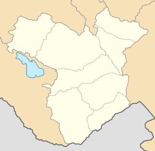
The Elizavetpol Governorate, also known after 1918 as the Ganja Governorate, was a province (guberniya) of the Caucasus Viceroyalty of the Russian Empire, with its capital in Yelisavetpol. The area of the governorate stretched 38,922.43 square versts and was composed of 1,275,131 inhabitants in 1916. The Elizavetpol Governorate bordered the Erivan Governorate to the west, the Tiflis Governorate and Zakatal Okrug to the north, the Dagestan Oblast to the northeast, the Baku Governorate to the east, and Iran to the south.

<span class="mw-page-title-main">Erivan Governorate</span> Territory of the Russian Empire from 1849 to 1917; now part of Armenia

The Erivan Governorate was a province (guberniya) of the Caucasus Viceroyalty of the Russian Empire, with its centеr in Erivan. Its area was 27,830 sq. kilometеrs, roughly corresponding to what is now most of central Armenia, the Iğdır Province of Turkey, and the Nakhchivan exclave of Azerbaijan. At the end of the 19th century, it bordered the Tiflis Governorate to the north, the Elizavetpol Governorate to the east, the Kars Oblast to the west, and Persia and the Ottoman Empire to the south. Mount Ararat and the fertile Ararat Valley were included in the center of the province.

<span class="mw-page-title-main">Tiflis Governorate</span> 1846–1917 guberniya of the Russian Empire

The Tiflis Governorate was a province (guberniya) of the Caucasus Viceroyalty of the Russian Empire with its administrative center in Tiflis. In 1897, it constituted 44,607 sq. kilometres in area and had a population of 1,051,032 inhabitants. The Tiflis Governorate bordered the Elizavetpol Governorate to the southeast, the Erivan Governorate to the south, the Kars Oblast to the southwest, the Batum Oblast to the west, the Kutaisi Governorate to the northwest, the Terek Oblast to the north, the Dagestan Oblast to the northeast, and after 1905, the Zakatal Okrug to the east. The governorate covered areas of central and southeastern Georgia, the partially recognised state of South Ossetia, most of the Lori Province of Armenia, small parts of northwestern Azerbaijan, and a minuscule southern part of Ingushetia within Russia.

Jevanshir <i>uezd</i> Uezd in Caucasus, Russian Empire

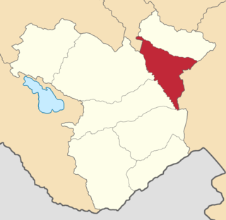
The Jevanshir uezd was a county (uezd) of the Elizavetpol Governorate of the Russian Empire, with its center in Terter.

Shusha <i>uezd</i> Uezd in Caucasus, Russian Empire

The Shusha uezd was a county (uezd) of the Elizavetpol Governorate of the Russian Empire, and then of the Ganja Governorate of Azerbaijan Democratic Republic with its center in Shusha in 1840–1921.

Jebrail <i>uezd</i> Uezd in Caucasus, Russian Empire

The Jebrail uezd, also known after 1905 as the Karyagino uezd, was a county (uezd) of the Elizavetpol Governorate of the Russian Empire with its center in Jebrail (Jabrayil) from 1873 until its formal abolition in 1921 by the Soviet authorities.

Aresh <i>uezd</i> Uezd in Caucasus, Russian Empire

The Aresh uezd, later known as the Agdash uezd, was a county (uezd) of the Elizavetpol Governorate of the Russian Empire and later of the Azerbaijan Democratic Republic with its center in Aresh from 1874 until its formal abolition in 1929 by Soviet authorities.

Nukha <i>uezd</i> Uezd in Caucasus, Russian Empire

The Nukha uezd was a county (uezd) of the Elizavetpol Governorate of the Russian Empire and later of the Azerbaijan Democratic Republic with its center in Nukha from 1868 until its formal abolition in 1921 by the Soviet authorities of the Azerbaijan SSR.

Elizavetpol <i>uezd</i> Uezd in Caucasus, Russian Empire

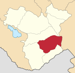
The Elizavetpol uezd, also known as the Ganja uezd after 1918, was a county (uezd) of the Elizavetpol Governorate of the Russian Empire, and later of the Azerbaijan Democratic Republic and Azerbaijan SSR until its formal abolition in 1929. The area of the Elizavetpol uezd corresponds to the modern-day Gadabay, Shamkir, Dashkasan, Goygol, and Samukh districts of Azerbaijan.

Erivan <i>uezd</i> County of the Russian Empire

The Erivan uezd was a county (uezd) of the Erivan Governorate of the Caucasus Viceroyalty of the Russian Empire. The uezd bordered the Etchmiadzin and Surmalu uezds to the west, the Nor Bayazet uezd to the east, the Sharur-Daralayaz uezd to the south, and Iran to the southwest. It included most of the Ararat Province and southern parts of the Kotayk Province of central Armenia, the Sadarak District of the Nakhchivan exclave of Azerbaijan, and the Aras corridor of the Aralık District of the Iğdır Province of Turkey. The administrative centre of the county was the city of Erivan.

Sharur-Daralayaz <i>uezd</i> Uezd in Caucasus, Russian Empire

The Sharur-Daralayaz uezd was a county (uezd) of the Erivan Governorate of the Caucasus Viceroyalty of the Russian Empire. It bordered the governorate's Erivan and Nor Bayazet uezds to the north, the Nakhichevan uezd to the south, the Zangezur and Jevanshir uezds of the Elizavetpol Governorate to the east, and Persia to the southwest. It included most of the Vayots Dzor Province of present-day Armenia and the Sharur District of the Nakhchivan exclave of present-day Azerbaijan. The administrative centre of the county was Bashnorashen.

Nakhichevan <i>uezd</i> Uezd in Caucasus, Russian Empire

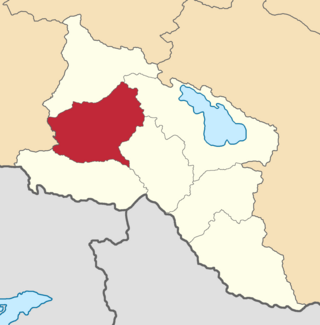
The Nakhichevan uezd was a county (uezd) of the Erivan Governorate of the Caucasus Viceroyalty of the Russian Empire. It bordered the governorate's Sharur-Daralayaz uezd to the north, the Zangezur uezd of the Elizavetpol Governorate to the east, and Iran to the south. The uezd's administrative center was the city of Nakhichevan.

Surmalu <i>uezd</i> Uezd in Caucasus, Russian Empire

The Surmalu uezd was a county (uezd) of the Erivan Governorate of the Caucasus Viceroyalty of the Russian Empire. It bordered the governorate's Etchmiadzin and Erivan uezds to the north, the Kars Oblast to the west, Persia to the east, and the Ottoman Empire to the south. The district made up most of the Iğdır Province of present-day Turkey. As part of the Russian Transcaucasus, the Surmalu uezd possessed economical importance for its abundantly rich salt mines in Kulp (Tuzluca), and spiritual importance to Armenians as the location of the culturally significant Mount Ararat. The administrative centre of the county was Igdyr.

Alexandropol <i>uezd</i> Uezd in Caucasus, Russian Empire

The Alexandropol uezd, known after 1924 as the Leninakan uezd, was a county (uezd) of the Erivan Governorate of the Caucasus Viceroyalty of the Russian Empire. The uezd bordered the governorate's Etchmiadzin and Nor Bayazet uezds to the south, the Borchaly and Akhalkalaki uezds of the Tiflis Governorate to the north, the Kazakh uezd of the Elizavetpol Governorate to the east, and the Kars Oblast to the west. The area of the uezd included most of the contemporary Shirak Province, and southern parts of the Lori Province of Armenia. The district was eponymously named for its administrative center, Aleksandropol, which at the time was a major railway hub of the Russian South Caucasus.

Nor Bayazet <i>uezd</i> Uezd in Caucasus, Russian Empire

The Nor Bayazet or Novobayazet uezd was a county (uezd) of the Erivan Governorate of the Caucasus Viceroyalty of the Russian Empire. The uezd bordered the Alexandropol uezd to the north, the Etchmiadzin and Erivan uezds to the west, the Sharur-Daralayaz uezd to the south, and the Kazakh, Elizavetpol, and Jevanshir uezds of the Elizavetpol Governorate to the east. Centered on Lake Sevan, the Nor Bayazet uezd included most of the contemporary province of Gegharkunik and northern parts of the Kotayk Province of Armenia. The administrative center of the uezd was the city Novobayazet for which the district was eponymously named.

Zugdidi <i>uezd</i> Uezd in Caucasus, Russian Empire

The Zugdidi uezd was a county (uezd) of the Kutaisi Governorate of the Caucasus Viceroyalty of the Russian Empire. It bordered the Sukhumi Okrug to the north, the Lechkhumi uezd to the east, the Senaki uezd to the south, and the Black Sea to the west. The area of the Zugdidi uezd corresponded to most of the contemporary Samegrelo-Zemo Svaneti region of Georgia. The county was eponymously named for its administrative center, Zugdidi.

Lenkoran <i>uezd</i> Uezd in Caucasus, Russian Empire

The Lenkoran uezd or Talysh uezd was a county (uezd) within the Baku Governorate of the Russian Empire, and then of the Azerbaijan Democratic Republic and the Azerbaijan SSR until its formal abolishment in 1929. The county was located on the southern part of the governorate, bordering Caspian sea to the east, Javad uezd to the north, and Iran to the southwest. The administrative centre of the county was the city of Lenkoran.

Geokchay <i>uezd</i> Uezd in Caucasus, Russian Empire

The Geokchay uezd was a county (uezd) of the Baku Governorate of the Russian Empire and then of the Azerbaijan Democratic Republic and Azerbaijan SSR until its formal abolishment in 1929. The uezd was located in the central part of the governorate, bordering the Kuba uezd to the north, the Shemakha uezd to the east, the Javad uezd to the south and the Elizavetpol Governorate to the west. The administrative center of the uezd was the city of Geokchay.

Akhalkalaki <i>uezd</i> Uezd in Caucasus, Russian Empire

The Akhalkalaki uezd was a county (uezd) of the Tiflis Governorate of the Caucasus Viceroyalty of the Russian Empire, and then of Democratic Republic of Georgia, with its administrative centre in Akhalkalak. The county bordered the Gori uezd to the north, the Borchaly uezd to the east, the Alexandropol uezd of the Erivan Governorate and the Kars and Ardahan okrugs of the Kars Oblast to the south, and the Akhaltsikhe uezd to the west. The area of the county roughly corresponded to the contemporary Samtskhe–Javakheti region of Georgia.

Tiflis <i>uezd</i> Uezd in Caucasus, Russian Empire

The Tiflis uezd was a county (uezd) of the Tiflis Governorate of the Caucasus Viceroyalty of the Russian Empire, and then of Democratic Republic of Georgia, with its administrative centre in Tiflis. The area of the uezd roughly corresponded to the contemporary Kvemo Kartli region of Georgia. The district bordered the Telavi uezd to the northeast, the Tionety and Dusheti uezds to the north, the Gori uezd to the northwest, the Borchaly uezd to the west, the Kazakh uezd of the Elizavetpol Governorate to the south, and the Signakh uezd to the east.

References

  1. "Выпуск 1-й. Учебные заведения." [Part 1. Educational institutions.]. Перепись просветительных учреждений Азербайджана 31 января 1922 года: списки просветительных учреждений [Census of educational institutions of Azerbaijan on 31 January 1922: lists of educational institutions. Part 1. Educational institutions.] (in Russian and Azerbaijani). Baku: Azerbaijani Central Statistical Bureau. 1922. p. 13 via State Public Historical Library of Russia.
  2. "Выпуск 4-й. Казахский уезд." [Part 4. Kazakh uezd.]. Азербайджанская сельскохозяйственная перепись 1921 года [1921 Azerbaijani agricultural census] (in Russian and Azerbaijani). Baku: Azerbaijani Central Statistical Bureau. 1922. p. 52 via State Public Historical Library of Russia.
  3. Chisholm, Hugh, ed. (1911). "Elisavetpol (town)"  . Encyclopædia Britannica . Vol. 09 (11th ed.). Cambridge University Press. p. 280; see lines four and five. ... until the Russians took it in 1804....
  4. 1 2 3 "Большой энциклопедический словарь Брокгауза и Ефрона. Казах" [Brockhaus and Efron Encyclopedia Dictionary. Kazakh]. Retrieved 2011-08-04.
  5. Mints, Isaac Israilevich (1971). Победа советской власти в Закавказье [The Soviet victory in Transcaucasus]. Moscow: Metsniereba. p. 423. Retrieved 2011-08-04.
  6. Hovannisian, Richard G. (1971–1996). The Republic of Armenia. Berkeley: University of California Press. p. 163. ISBN   0-520-01805-2. OCLC   238471.
  7. Кавказский календарь на 1913 год, pp. 152–159.
  8. Agnamaliyeva, Sevil; Kozlov, V.I. (1989). Долгожительство в Азербайджане: сборник научных трудов[Longovety in Azerbaijan: collection of scientific research]. Moscow: Institute of Ethnography named after Miklukha Maklay. Nauka. p. 84.
  9. Bournoutian 2018, p. 35 (note 25).
  10. Tsutsiev 2014, p. 50.
  11. 1 2 "Демоскоп Weekly - Приложение. Справочник статистических показателей". www.demoscope.ru. Retrieved 2022-06-28.
  12. Кавказский календарь на 1917 год, pp. 190–197.
  13. 1 2 Hovannisian 1971, p. 67.
  14. "КАЗАХСКИЙ УЕЗД (1926 г.)" [Kazakh Uyezd (1926)]. Retrieved 2011-08-04.

Bibliography

41°05′36″N45°21′58″E / 41.09333°N 45.36611°E / 41.09333; 45.36611