Elizavetpol uezd

Last updated
Elizavetpol uezd
Елисаветпольскій уѣздъ
Coat of Arms of Yelizavetpol Governorate.png
Elisabethpol Uyezd of Elisabethpol Governorate.png
Location in the Elizavetpol Governorate
Country Russian Empire
Viceroyalty Caucasus
Governorate Elizavetpol
Established1840
Abolished1929
CapitalYelisavetpol
(present-day Ganja)
Area
  Total9,930.73 km2 (3,834.28 sq mi)
Population
 (1916)
  Total272,477
  Density27/km2 (71/sq mi)
   Urban
21.19%
   Rural
78.81%

The Elizavetpol uezd, [lower-alpha 1] also known as the Ganja uezd [lower-alpha 2] after 1918, was a county ( uezd ) of the Elizavetpol Governorate of the Russian Empire, and later of the Azerbaijan Democratic Republic and Azerbaijan SSR until its formal abolition in 1929. [4] [5] The area of the Elizavetpol uezd corresponds to the modern-day Gadabay, Shamkir, Dashkasan, Goygol, and Samukh districts of Azerbaijan.

Contents

Geography

The Elizavetpol uezd was located in the northern part of Elizavetpol Governorate, bordering the Tiflis Governorate to the north, the Kazakh uezd to the west, the Aresh uezd to the east and Jevanshir uezd to the south. The administrative center of the uezd was the city of Yelisavetpol (Ganja).

The area of the county was 8,726 square verst and was divided into two parts: the northeastern lowlands steppes, irrigated by Kura River and its tributaries and southwestern mountainous part, watered by Kura's right bank tributaries. The lowland part was split by the Kura and Alazani rivers, the latter of which is not forested, less fertile and rarely used for farming. The mountainous part of the county stretched up to the mountain range adjacent to Lake Sevan. The highest peaks of uezd included Murovdag, (Azerbaijani : Murovdağ; 11,219 ft), Ginal-dag (Azerbaijani : Ginaldağ; 11,057 ft), Gyamysh (Azerbaijani : Gəmış; 12,263 ft), bordered Javanshir uezd of Elizavetpol Governorate and Novobayazet uezd of Erivan Governorate. The main rivers flowing down from these mountains into the lowland part of uezd and discharging into Kura were Kuruk-chay, Ganja-chay, Qoshqara-chay, Shamkhor-chay. [5]

History

After establishment of Russian rule over the khanates of the South Caucasus and the implementation of administrative reforms, the territories of Ganja khanate were incorporated into the Tiflis Governorate of the Russian Empire. On 10 April 1840, the Elizavetpol uezd was established within Georgian-Imereti Governorate, and on 14 December 1846 it was incorporated into the newly created Tiflis Governorate. In 1868, the uezd was reestablished within the newly founded Elizavetpol Governorate with its capital in Elizavetpol (present-day Ganja). [6]

After establishment of the Azerbaijan Democratic Republic in 1918, the uezd was renamed to the Ganja uezd, then named back to the Elizavetpol uezd and then again to the Ganja uezd on 10 August 1918. On 22 April 1920, a part of Ganja uezd was established as the Shamkhor uezd within Azerbaijan.

With the Red Army invasion of Azerbaijan and subsequent establishment of Soviet rule, the uezd was abolished on 8 April 1929 following an administrative reorganisation of the region. [7]

Administrative divisions

The subcounties ( uchastoks ) of the Elizavetpol uezd in 1912 were as follows: [8]

Name1912 populationArea
1-y uchastok (1-й участокъ)29,5471,515 square versts (1,724  km2 ; 666  sq mi )
2-y uchastok (2-й участокъ)27,8471,948 square versts (2,217  km2 ; 856  sq mi )
3-y uchastok (3-й участокъ)26,8801,298 square versts (1,477  km2 ; 570  sq mi )
4-y uchastok (4-й участокъ)35,8162,191 square versts (2,493  km2 ; 963  sq mi )
5-y uchastok (5-й участокъ)21,1661,111 square versts (1,264  km2 ; 488  sq mi )
6-y uchastok (6-й участокъ)5,134461 square versts (525  km2 ; 203  sq mi )

Economy

The population of the county was engaged primarily in agricultural farming, gardening, winemaking, corn and rice growing. Wine production in Azerbaijan was mostly seen in the city of Elizavetpol and German-populated town of Helenendorf where 450,000 canisters of wine were produced annually. In 1890, there were 107 factories and plants with a total number of workers at 2,136. There were two copper plants which produced 84% of the copper in Caucasus. [5]

Demographics

Russian Empire Census

According to the Russian Empire Census, the Elizavetpol uezd had a population of 162,788 on 28 January [ O.S. 15 January] 1897, including 90,584 men and 72,204 women. The majority of the population indicated Tatar [lower-alpha 3] to be their mother tongue, with significant Armenian and Russian speaking minorities. [11]

Linguistic composition of the Elizavetpol uezd in 1897 [11]
LanguageNative speakers%
Tatar [lower-alpha 3] 103,97063.87
Armenian 43,04026.44
Russian 7,2244.44
German 3,0861.90
Belarusian 2,8351.74
Georgian 6220.38
Ukrainian 3690.23
Polish 2990.18
Avar-Andean 2960.18
Kazi-Kumukh 2070.13
Greek 1780.11
Jewish 1010.06
Persian 790.05
Kyurin 390.02
Lithuanian 380.02
Kurdish 380.02
Udi 40.00
Romanian 20.00
Other3610.22
TOTAL162,788100.00

Kavkazskiy kalendar

According to the 1917 publication of Kavkazskiy kalendar , the Elizavetpol uezd had a population of 272,477 on 14 January [ O.S. 1 January] 1916, including 140,113 men and 132,364 women, 239,688 of whom were the permanent population, and 32,789 were temporary residents. The statistics indicated Shia Muslims to be the plurality of the population of the district, with significant Armenian, Sunni Muslim, and Russian minorities: [12]

Nationality Urban Rural TOTAL
Number%Number%Number%
Shia Muslims [lower-alpha 4] 37,61965.1688,01240.98125,63146.11
Armenians 12,12521.0056,58926.3568,71425.22
Sunni Muslims [lower-alpha 5] 5390.9351,18523.8451,72418.98
Russians 6,09110.5512,3535.7518,4446.77
Other Europeans 3190.556,0932.846,4122.35
Georgians 3030.521540.074570.17
North Caucasians 2020.352500.124520.17
Jews 3910.6870.003980.15
Asiatic Christians 580.101010.051590.06
Kurds 840.1500.00840.03
Roma 00.0020.0020.00
TOTAL57,731100.00214,746100.00272,477100.00

Notes

  1. 1 2 Prior to 1918, Azerbaijanis were generally known as "Tatars". This term, employed by the Russians, referred to Turkic-speaking Muslims of the South Caucasus. After 1918 with the establishment of the Azerbaijan Democratic Republic, and "especially during the Soviet era", the Tatar group identified itself as "Azerbaijani". [9] [10]
  2. Primarily Tatars. [13]
  3. Primarily Turco-Tatars. [13]

Related Research Articles

<span class="mw-page-title-main">Elizavetpol Governorate</span> Province of the Russian Empire from 1868 to 1917; now part of Azerbaijan

The Elizavetpol Governorate, also known after 1918 as the Ganja Governorate, was a province (guberniya) of the Caucasus Viceroyalty of the Russian Empire, with its capital in Yelisavetpol. The area of the governorate stretched 38,922.43 square versts and was composed of 1,275,131 inhabitants in 1916. The Elizavetpol Governorate bordered the Erivan Governorate to the west, the Tiflis Governorate and Zakatal Okrug to the north, the Dagestan Oblast to the northeast, the Baku Governorate to the east, and Iran to the south.

Borchaly <i>uezd</i> Uezd in Caucasus, Russian Empire

The Borchaly uezd was a county (uezd) of the Tiflis Governorate of the Caucasus Viceroyalty of the Russian Empire, and later of the independent and Soviet republics of Georgia. Its administrative center was the town of Shulavery. The area of the county roughly corresponded to the contemporary Lori Province of Armenia and the Kvemo Kartli region of Georgia.

Jevanshir <i>uezd</i> Uezd in Caucasus, Russian Empire

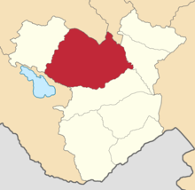
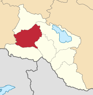
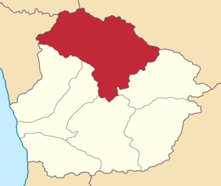
The Jevanshir uezd was a county (uezd) of the Elizavetpol Governorate of the Russian Empire, with its center in Terter.

Shusha <i>uezd</i> Uezd in Caucasus, Russian Empire

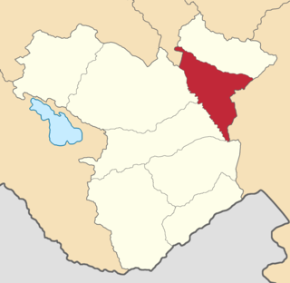
The Shusha uezd was a county (uezd) of the Elizavetpol Governorate of the Russian Empire, and then of the Ganja Governorate of Azerbaijan Democratic Republic with its center in Shusha in 1840–1921.

Jebrail <i>uezd</i> Uezd in Caucasus, Russian Empire

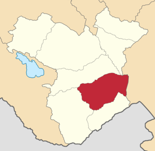
The Jebrail uezd, also known after 1905 as the Karyagino uezd, was a county (uezd) of the Elizavetpol Governorate of the Russian Empire with its center in Jebrail (Jabrayil) from 1873 until its formal abolition in 1921 by the Soviet authorities.

Kazakh <i>uezd</i> Uezd in Caucasus, Russian Empire

The Kazakh uezd was a county (uezd) of the Elizavetpol Governorate of the Russian Empire and later of the Azerbaijan Democratic Republic with its center in Kazakh from 1868 until its formal abolition in 1929 by the Soviet authorities of the Azerbaijan SSR. The area of the Kazakh uezd forms a large part of the modern-day Tavush Province and a small northeastern part of the Gegharkunik Province of Armenia, also forming most of the area of the Agstafa, Tovuz and Qazax districts of Azerbaijan.

Aresh <i>uezd</i> Uezd in Caucasus, Russian Empire

The Aresh uezd, later known as the Agdash uezd, was a county (uezd) of the Elizavetpol Governorate of the Russian Empire and later of the Azerbaijan Democratic Republic with its center in Aresh from 1874 until its formal abolition in 1929 by Soviet authorities.

Nukha <i>uezd</i> Uezd in Caucasus, Russian Empire

The Nukha uezd was a county (uezd) of the Elizavetpol Governorate of the Russian Empire and later of the Azerbaijan Democratic Republic with its center in Nukha from 1868 until its formal abolition in 1921 by the Soviet authorities of the Azerbaijan SSR.

Erivan <i>uezd</i> County of the Russian Empire

The Erivan uezd was a county (uezd) of the Erivan Governorate of the Caucasus Viceroyalty of the Russian Empire. The uezd bordered the Etchmiadzin and Surmalu uezds to the west, the Nor Bayazet uezd to the east, the Sharur-Daralayaz uezd to the south, and Iran to the southwest. It included most of the Ararat Province and southern parts of the Kotayk Province of central Armenia, the Sadarak District of the Nakhchivan exclave of Azerbaijan, and the Aras corridor of the Aralık District of the Iğdır Province of Turkey. The administrative centre of the county was the city of Erivan.

Sharur-Daralayaz <i>uezd</i> Uezd in Caucasus, Russian Empire

The Sharur-Daralayaz uezd was a county (uezd) of the Erivan Governorate of the Caucasus Viceroyalty of the Russian Empire. It bordered the governorate's Erivan and Nor Bayazet uezds to the north, the Nakhichevan uezd to the south, the Zangezur and Jevanshir uezds of the Elizavetpol Governorate to the east, and Persia to the southwest. It included most of the Vayots Dzor Province of present-day Armenia and the Sharur District of the Nakhchivan exclave of present-day Azerbaijan. The administrative centre of the county was Bashnorashen.

Zakatal <i>okrug</i> Former county in Caucasus, Russian Empire

The Zakatal okrug was a special administrative district (okrug) of the Caucasus Viceroyalty of the Russian Empire, part of the Tiflis Governorate from 1893 to 1905. The administrative centre of the district was Zakataly, and it corresponded to most of the contemporary districts of Balakan, Zaqatala and Qax of Azerbaijan. The Zakatal okrug was established from the territories of the erstwhile Free Jamaats of Jar-Balakan, bordering the Tiflis Governorate to the west, the Elizavetpol Governorate to the south and the Dagestan Oblast to the north. The district was the smallest independent administrative unit of the Russian Empire, similarly to the Sukhumi okrug.

Nor Bayazet <i>uezd</i> Uezd in Caucasus, Russian Empire

The Nor Bayazet or Novobayazet uezd was a county (uezd) of the Erivan Governorate of the Caucasus Viceroyalty of the Russian Empire. The uezd bordered the Alexandropol uezd to the north, the Etchmiadzin and Erivan uezds to the west, the Sharur-Daralayaz uezd to the south, and the Kazakh, Elizavetpol, and Jevanshir uezds of the Elizavetpol Governorate to the east. Centered on Lake Sevan, the Nor Bayazet uezd included most of the contemporary province of Gegharkunik and northern parts of the Kotayk Province of Armenia. The administrative center of the uezd was the city Novobayazet for which the district was eponymously named.

Etchmiadzin <i>uezd</i> Uezd in Caucasus, Russian Empire

The Etchmiadzin uezd was a county (uezd) of the Erivan Governorate of the Caucasus Viceroyalty of the Russian Empire. The uezd bordered the Alexandropol uezd to the north, the Nor Bayazet uezd to the east, Erivan uezd to the north, the Surmalu uezd to the south, and the Kars Oblast to the west. It included all of the Armavir Province and most of the Aragatsotn Province of present-day Armenia. The administrative centre of the county was Vagorshapat (Vagharshapat), also referred to as Etchmiadzin—the administrative capital of the Armenian Apostolic Church.

Javad <i>uezd</i> Uezd in Caucasus, Russian Empire

The Javad uezd, known after 1921 as the Salyan uezd, was a county (uezd) within the Baku Governorate of the Russian Empire and then of the Azerbaijan Democratic Republic and Azerbaijan SSR until its formal abolishment in 1929 by the Soviet authorities. The uezd was located in the central part of the governorate, bordering the Geokchay, Shemakha, and Baku uezds to the north, Caspian sea to the east, Lenkoran uezd to the south and Iran to the west. The administrative center of the uezd was the city of Salyan.

Shemakha <i>uezd</i> Uezd in Caucasus, Russian Empire

The Shemakha uezd was a county (uezd) within the Baku Governorate of the Russian Empire, and then of Azerbaijan Democratic Republic and Azerbaijan SSR until its formal abolishment in 1929. The county was located in central part of the Baku Governorate, bordering the Javad uezd to the south, Baku uezd to the east, Geokchay uezd to the west and Kuba uezd to the north. The administrative centre of the county was the city of Shemakha.

Geokchay <i>uezd</i> Uezd in Caucasus, Russian Empire

The Geokchay uezd was a county (uezd) of the Baku Governorate of the Russian Empire and then of the Azerbaijan Democratic Republic and Azerbaijan SSR until its formal abolishment in 1929. The uezd was located in the central part of the governorate, bordering the Kuba uezd to the north, the Shemakha uezd to the east, the Javad uezd to the south and the Elizavetpol Governorate to the west. The administrative center of the uezd was the city of Geokchay.

Tiflis <i>uezd</i> Uezd in Caucasus, Russian Empire

The Tiflis uezd was a county (uezd) of the Tiflis Governorate of the Caucasus Viceroyalty of the Russian Empire, and then of Democratic Republic of Georgia, with its administrative centre in Tiflis. The area of the uezd roughly corresponded to the contemporary Kvemo Kartli region of Georgia. The district bordered the Telavi uezd to the northeast, the Tionety and Dusheti uezds to the north, the Gori uezd to the northwest, the Borchaly uezd to the west, the Kazakh uezd of the Elizavetpol Governorate to the south, and the Signakh uezd to the east.

Lechkhumi <i>uezd</i> Uezd in Caucasus, Russian Empire

The Lechkhumi uezd was a county (uezd) of the Kutaisi Governorate of the Caucasus Viceroyalty of the Russian Empire. It bordered the Terek and Kuban oblasts to the north, the Sukhumi Okrug to the west, the Zugdidi, Senaki, and Kutais uezds to the south and the Racha uezd to the east. The area of the uezd corresponded to most of the contemporary Samegrelo-Zemo Svaneti region of Georgia. The administrative center of the Lechkhumi uezd was the town of Tsageri.

Sochinsky <i>okrug</i> Okrug in Caucasus, Russian Empire

The Sochinsky okrug was a district (okrug) of the Black Sea Governorate of the Caucasus Viceroyalty of the Russian Empire. It bordered the Kuban Oblast to the north, the Tuapsinsky okrug to the west, the Sukhumi okrug to the east, and the Black Sea to the south. The area of the Sochinsky okrug mostly corresponds to the Krasnodar Krai region of the Russian Federation. The district was eponymously named for its administrative centre, Sochi.

Batalpashinsky <i>otdel</i> Otdel in Caucasus, Russian Empire

The Batalpashinsky otdel was a Cossack district of the Kuban oblast of the Caucasus Viceroyalty of the Russian Empire. It bordered the Stavropol Governorate to the north, the Labinsky and Maykopsky otdels to the west, the Sochi and Sukhumi okrugs to the south, and the Terek Oblast to the east. The area of the Batalpashinsky otdel included most of the contemporary Karachay-Cherkessia region of Russia. The administrative capital was the city of Batalpashinskaya.

References

  1. Sâmî, Şemseddîn (1889). قاموس الاعلام: تاریخ و جغرافیا لغاتنی و تعبیر اصحله كافه اسماء خاصه‌یی جامعدر (in Ottoman Turkish). Mihran Matbaası. pp. 840–841 via Google Books.
  2. "Выпуск 1-й. Учебные заведения." [Part 1. Educational institutions.]. Перепись просветительных учреждений Азербайджана 31 января 1922 года: списки просветительных учреждений [Census of educational institutions of Azerbaijan on 31 January 1922: lists of educational institutions.] (in Russian and Azerbaijani). Baku: Azerbaijani Central Statistical Bureau. 1922. p. 13 via State Public Historical Library of Russia.
  3. "Выпуск 15-й. Ганджинский уезд." [Part 15. Ganja uezd.]. Азербайджанская сельскохозяйственная перепись 1921 года [1921 Azerbaijani agricultural census] (in Russian and Azerbaijani). Baku: Azerbaijani Central Statistical Bureau. 1922. p. 131 via State Public Historical Library of Russia.
  4. Chisholm, Hugh, ed. (1911). "Elisavetpol (government)"  . Encyclopædia Britannica . Vol. 9 (11th ed.). Cambridge University Press. p. 280; see final three lines. The government is divided into eight districts, Elisavetpol, Aresh, Jebrail, Jevanshir, Kazakh, Nukha, Shusha and Zangezur.
  5. 1 2 3 "Большой энциклопедический словарь Брокгауза и Ефрона. Елизаветполь" [Brockhaus and Efron Encyclopedia Dictionary. Elizavetpol]. Retrieved 2011-08-10.
  6. "Presidential Library. Coats of Arms and Emblems" . Retrieved 2011-08-10.[ permanent dead link ]
  7. "АДМИНИСТРАТИВНО-ТЕРРИТОРИАЛЬНОЕ ДЕЛЕНИЕ" [Administrative-territorial division](PDF). Archived from the original (PDF) on 2012-03-22. Retrieved 2011-08-10.
  8. Кавказский календарь на 1913 год, pp. 152–159.
  9. Bournoutian 2018, p. 35 (note 25).
  10. Tsutsiev 2014, p. 50.
  11. 1 2 "Демоскоп Weekly - Приложение. Справочник статистических показателей". www.demoscope.ru. Retrieved 2022-06-28.
  12. Кавказский календарь на 1917 год, pp. 190–197.
  13. 1 2 Hovannisian 1971, p. 67.

Bibliography

40°40′58″N46°21′38″E / 40.68278°N 46.36056°E / 40.68278; 46.36056