Kibler, Arkansas

Last updated

Kibler, Arkansas
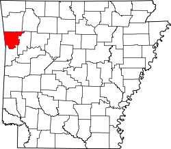
Crawford County Arkansas Incorporated and Unincorporated areas Kibler Highlighted 0536670.svg
Location of Kibler in Crawford County, Arkansas.
Coordinates: 35°25′31″N94°14′11″W / 35.42528°N 94.23639°W / 35.42528; -94.23639
Country United States
State Arkansas
County Crawford
Area
[1]
  Total5.00 sq mi (12.96 km2)
  Land5.00 sq mi (12.94 km2)
  Water0.01 sq mi (0.02 km2)
Elevation
[2]
456 ft (139 m)
Population
 (2020)
  Total1,005
  Density201.16/sq mi (77.67/km2)
Time zone UTC-6 (Central (CST))
  Summer (DST) UTC-5 (CDT)
FIPS code 05-36670
GNIS feature ID2404829 [2]

Kibler is a city in Crawford County, Arkansas, United States. It is part of the Fort Smith, Arkansas-Oklahoma Metropolitan Statistical Area. As of the 2010 Census the population was 961. [3]

Contents

Geography

Kibler is located in southern Crawford County 4 miles (6 km) south of Alma and 6 miles (10 km) east of Van Buren.

According to the United States Census Bureau, Kibler has a total area of 4.5 square miles (11.6 km2), all land. [3]

Demographics

Historical population
CensusPop.Note
1970 611
1980 79830.6%
1990 93116.7%
2000 9694.1%
2010 961−0.8%
2020 1,0054.6%
U.S. Decennial Census [4]

As of the census [5] of 2000, there were 969 people, 343 households, and 278 families residing in the city. The population density was 214.6 inhabitants per square mile (82.9/km2). There were 368 housing units at an average density of 81.5 per square mile (31.5/km2). The racial makeup of the city was 95.25% White, 0.10% Black or African American, 1.44% Native American, 1.86% Asian, 0.62% from other races, and 0.72% from two or more races. 1.44% of the population were Hispanic or Latino of any race.

There were 343 households, out of which 35.9% had children under the age of 18 living with them, 65.9% were married couples living together, 11.4% had a female householder with no husband present, and 18.7% were non-families. 16.9% of all households were made up of individuals, and 7.6% had someone living alone who was 65 years of age or older. The average household size was 2.83 and the average family size was 3.16.

In the city, the population was spread out, with 27.7% under the age of 18, 9.5% from 18 to 24, 26.6% from 25 to 44, 25.3% from 45 to 64, and 10.9% who were 65 years of age or older. The median age was 37 years. For every 100 females, there were 99.4 males. For every 100 females age 18 and over, there were 98.6 males.

The median income for a household in the city was $33,889, and the median income for a family was $36,761. Males had a median income of $27,955 versus $19,583 for females. The per capita income for the city was $15,763. About 11.3% of families and 14.8% of the population were below the poverty line, including 22.4% of those under age 18 and 21.9% of those age 65 or over.

Related Research Articles

<span class="mw-page-title-main">Crawford County, Arkansas</span> County in Arkansas, United States

Crawford County is a county located in the Ozarks region of the U.S. state of Arkansas. As of the 2020 census, the population was 60,133. The county seat and largest city is Van Buren. Crawford County was formed on October 18, 1820, from the former Lovely County and Indian Territory, and was named for William H. Crawford, the United States Secretary of War in 1815.

<span class="mw-page-title-main">Oppelo, Arkansas</span> City in Arkansas, United States

OppeloAH-pə-loh is a city in Conway County, Arkansas, United States. The population was 781 at the 2010 census.

<span class="mw-page-title-main">Cedarville, Arkansas</span> City in Arkansas, United States

Cedarville is a city in Crawford County, Arkansas, United States. It is part of the Fort Smith, Arkansas-Oklahoma Metropolitan Statistical Area. The population was 1,410 at the 2020 census.

<span class="mw-page-title-main">Dyer, Arkansas</span> City in Arkansas, United States

Dyer is a city in Crawford County, Arkansas, United States. It is part of the Fort Smith, Arkansas-Oklahoma Metropolitan Statistical Area. The population was 876 at the 2010 census.

<span class="mw-page-title-main">Mountainburg, Arkansas</span> City in Arkansas, United States

Mountainburg is a town in Crawford County, Arkansas, United States. It is part of the Fort Smith, Arkansas-Oklahoma Metropolitan Statistical Area. As of the 2010 census the population was 631.

<span class="mw-page-title-main">Mulberry, Arkansas</span> City in Arkansas, United States

Mulberry is a city in Crawford County, Arkansas, United States. It is part of the Fort Smith, Arkansas-Oklahoma Metropolitan Statistical Area. The population was 1,655 as of the 2010 Census, an increase of 1.72% from 1,627 in 2000.

<span class="mw-page-title-main">Carthage, Arkansas</span> Town in Arkansas, United States

Carthage is a town in Dallas County, Arkansas, United States. The population was 343 at the 2010 census.

<span class="mw-page-title-main">Coal Hill, Arkansas</span> City in Arkansas, United States

Coal Hill is a city in Johnson County, Arkansas, United States. The population was 1,012 at the 2010 census.

<span class="mw-page-title-main">Hartman, Arkansas</span> City in Arkansas, United States

Hartman is a city in Johnson County, Arkansas, United States. The population was 519 at the 2010 census.

<span class="mw-page-title-main">Pottsville, Arkansas</span> City in Arkansas, United States

Pottsville is a city in Pope County, Arkansas, United States. As of the 2020 census the population was 3,140. It is part of the Russellville Micropolitan Statistical Area.

<span class="mw-page-title-main">Mansfield, Arkansas</span> City in Arkansas, United States

Mansfield is a city in Scott and Sebastian counties Arkansas, United States. The Sebastian County portion of the city is part of the Fort Smith, Arkansas-Oklahoma Metropolitan Statistical Area. As of the 2010 Census, the population was 1,139. The population was 1,097 at the 2000 census.

<span class="mw-page-title-main">Hackett, Arkansas</span> City in Arkansas, United States

Hackett is a city in Sebastian County, Arkansas, United States. It is part of the Fort Smith, Arkansas-Oklahoma Metropolitan Statistical Area. The population was 812 at the 2010 census.

<span class="mw-page-title-main">Douglass, Kansas</span> City in Butler County, Kansas

Douglass is a city in Butler County, Kansas, United States. As of the 2020 census, the population of the city was 1,555.

<span class="mw-page-title-main">Hepler, Kansas</span> City in Crawford County, Kansas

Hepler is a city in Crawford County, Kansas, United States. As of the 2020 census, the population of the city was 90.

Crawford is a town in Washington County, Maine, United States. The town was named after William H. Crawford, Secretary of the Treasury. The population was 93 at the 2020 census.

<span class="mw-page-title-main">Otisville, Michigan</span> Village in Michigan, United States

Otisville is a village in Forest Township, Genesee County in the U.S. state of Michigan. The population was 864 at the 2010 census. It is located along M-15, just south of M-57. It is part of the Flint metropolitan area.

<span class="mw-page-title-main">Cooter, Missouri</span> City in Missouri, United States

Cooter is a city in Pemiscot County, Missouri, United States. The population was 343 at the 2020 census.

<span class="mw-page-title-main">Bourbon, Missouri</span> City in Missouri, United States

Bourbon is a city in Crawford County, Missouri, United States. At the time of the 2010 census, it had a population of 1,632.

<span class="mw-page-title-main">Houston Lake, Missouri</span> City in Missouri, United States

Houston Lake is a city in Platte County, Missouri, and is part of the Kansas City metropolitan area within the United States. The population was 235 at the 2010 census.

<span class="mw-page-title-main">Forest Acres, South Carolina</span> City in South Carolina, United States

Forest Acres is a city in Richland County, South Carolina, United States. The population was 10,606 at the 2020 census. It is part of the Columbia, South Carolina, Metropolitan Statistical Area and is an enclave of the city of Columbia.

References

  1. "2020 U.S. Gazetteer Files". United States Census Bureau. Retrieved October 29, 2021.
  2. 1 2 U.S. Geological Survey Geographic Names Information System: Kibler, Arkansas
  3. 1 2 "Geographic Identifiers: 2010 Demographic Profile Data (G001): Kibler city, Arkansas". U.S. Census Bureau, American Factfinder. Archived from the original on February 12, 2020. Retrieved June 18, 2014.
  4. "Census of Population and Housing". Census.gov. Retrieved June 4, 2015.
  5. "U.S. Census website". United States Census Bureau . Retrieved January 31, 2008.