Related Research Articles

Kilkeel is a small town, civil parish and townland in County Down, Northern Ireland. It is the southernmost town in Northern Ireland. It lies within the historic barony of Mourne. Kilkeel town is the main fishing port on the Down coast, and its harbour is home to the largest fishing fleet in Northern Ireland. It had a population of 6,633 people at the 2021 census. The town contains the ruins of a 14th-century church and fort, winding streets and terraced shops. It lies just south of the Mourne Mountains.

Annalong is a seaside village in County Down, Northern Ireland at the foot of the Mourne Mountains. Annalong is in the civil parish of Kilkeel, the barony of Mourne, and the Newry and Mourne District Council area. It had a population of 1,805 at the 2011 Census. The village formerly exported dressed granite and is now a fishing and holiday resort.

Slieve Binnian is one of the Mourne Mountains in County Down, Northern Ireland, 9 km north of Kilkeel. It is the third-highest mountain in Northern Ireland at 747 metres (2,451 ft). The summit is broad and flat with rocky tors at the north and south ends, with the Back Castles, impressive towers of granite, in between. To the south-west is Wee Binnian (460m). It lies east of Silent Valley Reservoir and west of the Annalong Valley. The Mourne Wall also crosses over Slieve Binnian.
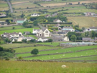
Attical or Atticall is a small village and townland in the Mourne Mountains of County Down, Northern Ireland. It is situated in the civil parish of Kilkeel and the historic barony of Mourne. In the 2001 Census it had a population of 153 people. It lies within the Newry and Mourne District Council area.
Ballymartin is one of several places on the island of Ireland.
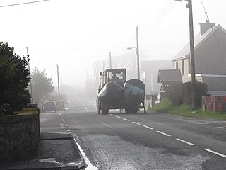
Dunnaval is a small village and townland near Kilkeel in County Down, Northern Ireland. It is situated in the civil parish of Kilkeel and the historic barony of Mourne. In the 2001 Census it had a population of 147 people. It lies within the Newry and Mourne District Council area.

Benraw is a townland of 860 acres in County Down, Northern Ireland, two miles north of Leitrim and six miles from Castlewellan. It is situated in the civil parish of Drumgooland and the historic barony of Iveagh Upper, Lower Half. It is set in the middle of the Dromara Hills and Slieve Croob. It has an average population of 50 people. It contains two roads: the Whitehill Road and the Benraw Road. It is in the middle of the townlands Leitrim, Legananny and Derryneill. It is a very mountainous area and the two main mountains in Benraw are Benraw Mountain and The Whitehill. Benraw is also close to Legananny Dolmen.

Kilcoo is a small village and civil parish in County Down, Northern Ireland. It lies between Rathfriland and Castlewellan and is within the Newry, Mourne and Down District Council area. The village is on the A25 Dublin Road 6 kilometres (4 mi) south-west of Castlewellan. Kilcoo had a population 1415 people in the 2001 Census.
Annaclone is a village and civil parish between Rathfriland and Banbridge in south County Down, Northern Ireland, about 7 km south-east of Banbridge. The village is situated in the townlands of Ardbrin and Tullintanvally and both it and the civil parish are located in the historic barony of Iveagh Upper, Upper Half. It had a population of 150 people in the 2011 Census.

Mourne is a barony in County Down, Northern Ireland. It lies in the south-east of the county, with the Irish Sea to its east. It is bordered by two other baronies: Iveagh Upper, Lower Half and Iveagh Upper, Upper Half to the north and west. Called at one time Bairrche its present name of Mourne comes from the Múrna, a people who hail from a territory of the same name in modern County Monaghan.

Iveagh Upper, Lower Half is the name of a barony in County Down, Northern Ireland. It was created by 1851 with the division of the barony of Iveagh Upper into two. It lies in the centre of the county, and is bordered by six other baronies: Iveagh Upper, Upper Half and Lordship of Newry to the west; Mourne to the south; Kinelarty and Lecale Upper to the east; and Iveagh Lower, Upper Half to the north.
Killokennedy is a civil parish in County Clare, Ireland.
Ballymore is a civil parish and townland in County Armagh, Northern Ireland. It is situated in the historic barony of Orior Lower.
Saintfield is a civil parish in County Down, Northern Ireland. It is situated in the historic barony of Castlereagh Upper.
Magheradrool is a civil parish in County Down, Northern Ireland. It is situated mainly in the historic barony of Kinelarty, with one townland in the barony of Iveagh Lower, Lower Half. It is also a townland of 503 acres.
Newry is a civil parish in County Armagh and County Down, Northern Ireland. It is situated in the historic baronies of Iveagh Upper, Lower Half and Lordship of Newry in County Down and the baronies of Orior Upper and Oneilland West in County Armagh.

Corthoon or Cartrongibbagh is a townland in County Leitrim, Connacht, Ireland. The townland is located in the northern part of the county, close to the borders of County Donegal and County Fermanagh. The main service town is Manorhamilton.
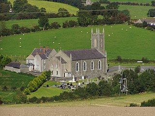
Aghyoghill is a rural townland in County Down, Northern Ireland. It has an area of 191.7 acres (0.78 km2). It is situated in the civil parish of Kilkeel and the historic barony of Mourne, located 4 miles west of Kilkeel. It lies within the Newry, Mourne and Down District Council.
