Kings Royalty, Prince Edward Island

Last updated
Map of Prince Edward Island highlighting Kings Royalty.png

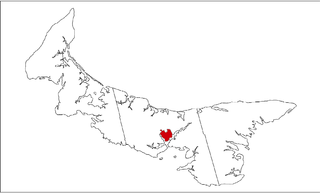
Georgetown Royalty is the royalty for Kings County, Prince Edward Island, Canada. [1]

Kings County, Prince Edward Island Place

Kings County is located in eastern Prince Edward Island, Canada.

Prince Edward Island Province of Canada

Prince Edward Island is a province of Canada consisting of the Atlantic island of the same name along with several much smaller islands nearby. PEI is one of the three Maritime Provinces. It is the smallest province of Canada in both land area and population, but it is the most densely populated. Part of the traditional lands of the Mi'kmaq, it became a British colony in the 1700s and was federated into Canada as a province in 1873. Its capital is Charlottetown. According to the 2016 census, the province of PEI has 142,907 residents.

Canada Country in North America

Canada is a country in the northern part of North America. Its ten provinces and three territories extend from the Atlantic to the Pacific and northward into the Arctic Ocean, covering 9.98 million square kilometres, making it the world's second-largest country by total area. Canada's southern border with the United States is the world's longest bi-national land border. Its capital is Ottawa, and its three largest metropolitan areas are Toronto, Montreal, and Vancouver. As a whole, Canada is sparsely populated, the majority of its land area being dominated by forest and tundra. Consequently, its population is highly urbanized, with over 80 percent of its inhabitants concentrated in large and medium-sized cities, many near the southern border. Canada's climate varies widely across its vast area, ranging from arctic weather in the north, to hot summers in the southern regions, with four distinct seasons.

The township was established as part of the colonial survey of 1764 undertaken by Capt. Samuel J. Holland. It was intended to host the shire town of Kings County, Georgetown. The township is located on a peninsula bounded by the Cardigan River on the north and the Brudenell River on the south.

Samuel Holland British Army officer

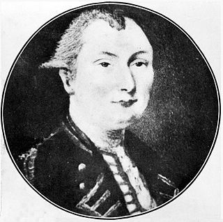
Samuel Johannes Holland was a Dutch-born Royal Engineer and first Surveyor General of British North America.

Georgetown, Prince Edward Island Place in Prince Edward Island, Canada

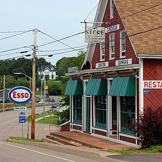
Georgetown is a former town located within the Town of Three Rivers in Kings County, Prince Edward Island, Canada. It is the shire town for Kings County. It amalgamated with the Town of Montague, the rural municipalities of Brudenell, Cardigan, Lorne Valley, Lower Montague, and Valleyfield, and portions of three adjacent unincorporated areas in 2018.

Originally, Georgetown was unincorporated, therefore the "royalty" and the community were largely synonymous, with many using the term "Georgetown Royalty". Following Georgetown's incorporation, remaining parts of the township became known as North Royalty and Brudenell.

Kings Royalty is part of St. George's Parish.

See also

Related Research Articles

Stratford, Prince Edward Island Town in Prince Edward Island, Canada

Stratford is a town located in Queens County, Prince Edward Island.

Queens County, Prince Edward Island Place

Queens County is a county in the province of Prince Edward Island, Canada. It is the largest county in the province by population with 82,017 (2016), land area, and highest average income. Charlottetown is the county seat of Queens County, and is the largest city and the capital of Prince Edward Island.

Montague, Prince Edward Island Place in Prince Edward Island, Canada

Montague is a former town located within the Town of Three Rivers in Kings County, Prince Edward Island, Canada. It amalgamated with the Town of Georgetown, the rural municipalities of Brudenell, Cardigan, Lorne Valley, Lower Montague, and Valleyfield, and portions of three adjacent unincorporated areas in 2018.

Prince Royalty, Prince Edward Island human settlement in Prince Edward Island, Canada

Prince Royalty is the royalty for Prince County, Prince Edward Island, Canada.

Queens Royalty, Prince Edward Island human settlement in Prince Edward Island, Canada

Queens Royalty is the royalty for Queens County, Prince Edward Island, Canada.

St. Davids Parish, Prince Edward Island human settlement

St. David's Parish was created as a civil parish in Prince County, Prince Edward Island, Canada, during the 1764-1766 survey of Samuel Holland.

St. Georges Parish, Prince Edward Island

St. George's Parish was created as a civil parish in Kings County, Prince Edward Island, Canada, during the 1764-1766 survey of Samuel Holland.

Brudenell River Provincial Park

Brudenell River Provincial Park is a provincial park in Prince Edward Island, Canada. It lies on the north side of the Brudenell River, and some of its land is also used by Rodd Brudenell Resort. Brudenell River is the largest provincial park in eastern Prince Edward Island. It has two 18-hole golf courses, Brudenell River Golf Course and Dundarave Golf Course.

Prince County, Prince Edward Island Place

Prince County is located in western Prince Edward Island, Canada. The county's defining geographic feature is Malpeque Bay, a sub-basin of the Gulf of St. Lawrence, which creates the narrowest portion of Prince Edward Island's landmass, an isthmus upon which the city of Summerside is located.

Sherwood, Prince Edward Island human settlement in Prince Edward Island, Canada

Sherwood is a neighbourhood of the city of Charlottetown in central Queens County, Prince Edward Island, Canada.

Winsloe is a neighbourhood in the northwestern part of the Canadian city of Charlottetown, Prince Edward Island.

East Royalty is a neighbourhood of the Canadian city of Charlottetown, Prince Edward Island.

Daniel Gordon was a businessman, ship owner and politician in Prince Edward Island. He represented 2nd Kings from 1866 to 1873 and 5th Kings from 1876 to 1904 in the Legislative Assembly of Prince Edward Island as a Conservative member

Cardigan, Prince Edward Island Place in Prince Edward Island, Canada

Cardigan, Prince Edward Island was a municipality that held community status in Prince Edward Island, Canada. It was a fishing community in eastern Kings County. The community was named after James Brudenell, 5th Earl of Cardigan, later Duke of Montague. Situated on the Cardigan River and originally named Cardigan Bridge, the community started and grew as a result of the shipbuilding industry and lumber trade.

The Three Rivers river in Canada

The Three Rivers are the three tidal estuaries in eastern Prince Edward Island, Canada. The water bodies are the Brudenell, Cardigan and Montague rivers, which in 2004 were included on the list of outstanding Canadian Heritage Rivers. The rivers are navigable by canoe for 52 kilometres (32 mi).

Long River, Prince Edward Island locality in Prince Edward Island

Long River is an unincorporated community, in Queens County. Long River is in Lot 20 of Statistics Canada

Three Rivers is a town within Kings County in Prince Edward Island that was incorporated on September 28, 2018 through an amalgamation of seven municipalities and adjacent unincorporated areas. The municipalities that were amalgamated included two towns – Georgetown and Montague – and five rural municipalities – Brudenell, Cardigan, Lorne Valley, Lower Montague, and Valleyfield.

References

  1. Canada, Government of Canada, Statistics. "Census Profile, 2016 Census - Kings, Royalty, Township and royalty [Census subdivision], Prince Edward Island". www12.statcan.gc.ca. Retrieved 13 April 2018.

Coordinates: 46°11′54″N63°32′30″W / 46.19833°N 63.54167°W / 46.19833; -63.54167

Geographic coordinate system Coordinate system

A geographic coordinate system is a coordinate system that enables every location on Earth to be specified by a set of numbers, letters or symbols. The coordinates are often chosen such that one of the numbers represents a vertical position and two or three of the numbers represent a horizontal position; alternatively, a geographic position may be expressed in a combined three-dimensional Cartesian vector. A common choice of coordinates is latitude, longitude and elevation. To specify a location on a plane requires a map projection.