Kumbhariya, Banaskantha district

Last updated

Kumbhariya
village
Kumbhariya Jain temple, Banaskantha.jpg
Interior of the Mahavira Temple, 1062
India Gujarat location map.svg
Red pog.svg
Kumbhariya
Location in Gujarat, India
India location map.svg
Red pog.svg
Kumbhariya
Kumbhariya (India)
Asia laea location map.svg
Red pog.svg
Kumbhariya
Kumbhariya (Asia)
Coordinates: 24°19′31″N72°51′44″E / 24.325361°N 72.862334°E / 24.325361; 72.862334
CountryFlag of India.svg  India
State Gujarat
District Banaskantha district
PanchayatGram Panchayat
Founded by Rana Kumbha
Population
 (2011) [1]
  Total3,482
Languages
  Official Gujarati [2]
Time zone UTC+5:30 (IST)
PIN
385110
Vehicle registration GJ
Distance from Palanpur 101 kilometres (63 mi)
Distance from Ahmedabad 130 kilometres (81 mi)
Website gujaratindia.com
Sanctum and lingam of the Mahadev (Shiva) Temple Kumbharia Mahadev Temple, Inner sanctum 01.jpg
Sanctum and lingam of the Mahadev (Shiva) Temple

Kumbhariya is a village of historical, archaeological and religious importance with cultural heritage in Danta Taluka of Banaskantha district, Gujarat, India. [1]

Contents

It is notable for five medieval Jain temples, built between 1062 and 1231, similar in design and typical of the Jain Māru-Gurjara architecture style. [3] The Hindu Shiva Kumbheshwar Mahadev Temple is of similar date and style.

Location

It is located at a distance of 1.7 km from Ambaji. Kumbhariya village is located in Taluka, Danta of Banaskantha, North Gujarat, India .

History

It has historical Jain temple of Neminatha which dates back to the 13th century. [4] The Kumbhariya Jain temple of Shri Neminatha Bhagwan is now heritage center in Gujarat. [5] The area was earlier known by name of Arasur and the village is said to have been founded and named after Rana Kumbha of Mewar in the 15th century. [6]

Demography

Ceiling rosette of the Mahavira Jain temple, 1062 Kumbhariya Jain temple - Ceiling (2).jpg
Ceiling rosette of the Mahavira Jain temple, 1062

As of 2011 Indian Census, Kumbhariya had a total population of 3,482, of which 1,772 were males and 1,710 were females. Population within the age group of 0 to 6 years was 683. The total population of literates in Kumbhariya was 1,395, which constituted 40.1% of the population, of which males were at 49.3% and females were 30.5%. The effective literacy rate of 7+ population was 49.8%. The Scheduled Castes and Scheduled Tribes population was 30 and 1,849 respectively. Kumbhariya had 671 households in 2011. [1]

Climate

Kumbhariya village enjoys all types of weather. In Summer, it's hot and humid and temperature remains between 26 and 46 °C Degrees with hot winds. In Winter, the temperature ranges between 10 and 36 degrees Celsius during this period, which is quite cold and best time and in Monsoon Season, the average rainfall is about 15 to 30 inches per season, sometimes even heavy rainfall. Kumbhariya village because of Ambaji is at 480 m of altitude. Therefore, weather remains relatively pleasant throughout the year.

Economy

The population is largely dependent on marginal work or as agricultural labour with only about 249 were cultivators, who own their farms. [1]

Education

The village Kumbhariya also houses educational institute Shree Ambaji Arts College managed by Shree Arasuri Ambaji Mata Devasthan Trust, Ambaji established in 1991 [7]

Higher education

Schools

Temples

Jain temples

The five Jain temples are close together. The Mahavira temple has an elaborate interior, similar to the Dilwara Jain Temples of Mount Abu, not far away. It dates to 1062. South of it, the Parshvanatha Temple of 1105 is slightly larger and at least as elaborately decorated. To the north are the Shantinatha Temple of 1082, the Neminatha Temple of 1134 (and later), and the smaller Sambhavanatha Temple of 1231. [3]

Hindu temple

Rear of the Mahadev Temple Kumbharia Mahadev Temple, Back view.jpg
Rear of the Mahadev Temple

There are ancient temples dedicated to Amba or Chamunda and Shiva - the temples of Chamunda Mata and Someshwar Mahadev, respectively, near the river stream. [8] The Kumbhariya Mahadev temple is State Protected Monument (S-GJ-11).

Transportation

As Ambaji town is nearest which one and half km away from village Kumbhariya, there is a bus-station at Ambaji of Gujarat State Road Transport Corporation (GSRTC) connecting to all major cities of India, and a railway station is at Palanpur, Banaskantha district, North Gujarat.

Road

As Ambaji town is nearest which one and half km away from village Kumbhariya, there is a bus-station at Ambaji. Kumbhariya can be reached through Himatnagar road which is connected with National Highway 48 (Mumbai to Delhi). The other road which passes through Palanpur and Danta and connects with State Highway SH 56 to reach Ambaji.

Rail

The nearest railway station of Gujarat is at Palanpur Junction which comes under the administrative control of Western Railway zone of the Indian Railways. It has direct rail links on the broad gauge to the cities of Chennai, Thiruvananthapuram, Mysore, Bangalore, Pune, Mumbai, Jaipur, Jodhpur, Delhi, Dehradun, Muzaffarpur, Bareilly and Jammu. It is connected to most of the cities and towns in Gujarat such as Ahmedabad, Surat, Vadodara, Bhuj, Rajkot, Jamnagar and Porbandar. Indian Railways' proposal to double the broad gauge line between Palanpur and Samakhiali has received government backing.[ citation needed ] The doubling will benefit the districts of Kutch, Patan and Banaskantha in the state of Gujarat. The other way of nearest Railway station is at Abu Road which is 22 km away from Ambaji.

Air

As Ambaji town is nearest which one and half km away from village Kumbhariya. The nearest Airport is the Deesa Airport (also spelled Disa Airport), an airport in Deesa, Gujarat but this airport is not working nowadays, originally built for Palanpur. [9] it is just 82 km from Palanpur city. The nearest International Airport is Sardar Vallabhbhai Patel International Airport, Ahmedabad which is 179 km far from Ambaji Temple Town.

Surrounding cites

Related Research Articles

Kheda, also known as Kaira, is a city and a municipality in the Indian state of Gujarat. It was former administrative capital of Kheda district. India's First Deputy Prime Minister Vallabhbhai Patel Was Born In Kheda District of Gujarat State.Kheda city is famous for tobacco farming. The nearest railway station is Mahemadavad Kheda Road. Nearest Airport is Ahmedabad airport. Nearest Bus Station is "Kheda Bus Station".

<span class="mw-page-title-main">Navsari district</span> District of Gujarat in India

Navsari is an administrative district in the state of Gujarat in India, with its headquarters at the city of Navsari. The district covers an area of 2,211 square kilometres and was formed in 1997 after Valsad district was split into Valsad and Navsari districts. It is the largest producer of chikoos in India.

<span class="mw-page-title-main">Abu Road</span> Place in Rajasthan, India

Abu Road is a city and sub-district in Sirohi district of Rajasthan state in western India, lies on the bank of West Banas River. It is the tehsil and sub-district headquarters and the largest city in Sirohi District in terms of area and population. Its railway station is an important stop on the main Indian Railways line between New Delhi and Ahmedabad and registers an impressive growth in passenger traffic and revenue generation for North Western Railway zone. The popular hill station, Mount Abu is 27 km up the hill from Abu Road.

<span class="mw-page-title-main">Palanpur</span> City in Gujarat, India

Palanpur is a city and a municipality of Banaskantha district in the Indian state of Gujarat. Palanpur is the administrative headquarters of Banaskantha district. Palanpur is the ancestral home to an industry of Indian diamond merchants.

Danta is a city in the taluka of the same name in the Banaskantha district of the Indian state of Gujarat. It lies about 150 km north of Ahmedabad city, and on the border of Gujarat with Rajasthan.

<span class="mw-page-title-main">Valsad district</span> District of Gujarat in India

Valsad district is one of the 33 districts in the Western Indian state of Gujarat. It is bound by Navsari district to the north, Nashik district of Maharashtra state to the east, and Dadra and Nagar Haveli district of the Dadra and Nagar Haveli and Daman and Diu (DNHDD) union territory and the Palghar district of Maharashtra to the south. The Arabian Sea lies west of the district. The coastal Daman enclave of DNHDD is bounded by Valsad district on the north, east, and south. The district's administrative capital is Valsad. The district's largest city is Vapi.

Dhrangadhra is a town, taluka headquarters and a municipality in Surendranagar district in the state of Gujarat, India. During the period of the British Raj, the city was the capital of Dhrangadhra State, one of the eight first-class princely states of the Kathiawar Agency in the Bombay Presidency.

Ambaji (Ambājī) is a census town in Banaskantha district in the state of Gujarat, India. It is known for its historical connections with sites of cultural heritage.

Vadgam is located in India, situated in Banaskantha district in northern Gujarat. Administratively, it is a Taluka. There are 110 villages under this Taluka. Vadgam region also known as a Dhandhar.

Deesa is a city and a municipality in the Banaskantha district in the state of Gujarat, India.

<span class="mw-page-title-main">Kalol, Gandhinagar</span> City in Gujarat, India

Kalol is a city in Gandhinagar district in the Indian state of Gujarat, located alongside Gujarat State Highway 41 between the cities of Mehsana and Ahmedabad.

<span class="mw-page-title-main">Palanpur Agency</span>

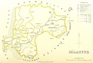
Palanpur Agency, also spelled Pahlunpore Agency, was a political agency or collection of princely states in British India, within the Gujarat Division of Bombay Presidency. In 1933, the native states of the Mahi Kantha Agency, except for Danta, were included in the Western India States Agency. The agency, headquartered at Palanpur, oversaw some 17 princely states and estates in the area, encompassing an area of 6393 square miles (16,558 km2) and a population, in 1901, of 467,271.

<span class="mw-page-title-main">Dhari, Gujarat</span> Village/Town in Gujarat, India

Dhari is a town in Amreli District in Indian state of Gujarat, India. It is an administrative headquarter of the Dhari tehsil(almost 87 villages and ness).Dhari is the most populous town in Amreli District as per census 2011 with 30352 population. Dhari is located on the bank of Shetrunji River, 42 km(26.2 mi) from district headquarter Amreli & 318 km(199.8 mi) from state capital Gandhinagar. Dhari is famous for kesar mango and Asiatic lion. Dhari is capital of East Gir Forest.

Shihori is a village in Banaskantha district of the Indian state of Gujarat. It is the administrative headquarters of the Kankrej Taluka and has a population of more than 10,000.

<span class="mw-page-title-main">Kherva</span> Village in Gujarat, India

Kherva is a village in the Mehsana District, Gujarat, India, situated on State Highway 73 between Gandhinagar and Mehsana. It borders the following villages: Devarasan, Kadavasan, Mulsan, Jagudan, Sanganpur, Punasan, Hebuva, Udalpur, Gunjala, Dharusan, and Dhamnava.

Delvada, also known as Delwada, is a village in Una Taluka, Gir Somnath district, Gujarat, India. It is located on the banks of the Machundri River, 5 km from Una and about 8 km from Diu. Several religious and social groups exist in Delvada. These include: Kolis, Patels, Muslim, Brahmin, Lohana, and Sindhi. Due to its proximity to the Arabian Sea, the weather is extremely humid.

Sami is a town in Sami Taluka of Patan district of Gujarat, India.

Jagana is a village in the Palanpur taluka of Banaskantha district in northern Gujarat, India. The villages Vasna, Bhagal, Sedrasana are located near to Jagana and it is just 6 km away from the district headquarters, Palanpur.

<span class="mw-page-title-main">Kumbharia Jain temples</span> Jain temples in the state of Gujarat

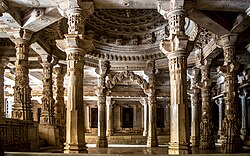
The Kumbharia Jain temples is a group of five Jain temples in the Kumbhariya, Banaskantha district in Gujarat, India. Constructed from 1062 to 1231 CE during the reign of the Chaulukya dynasty, they are noted for their elaborate architecture.

<span class="mw-page-title-main">Ambaji Fair</span>

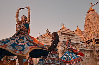
Ambaji Fair is held at Ambaji in Danta taluka of Banaskantha district. Ambaji, 50 km away from Palanpur, creates the same atmosphere as every Poonam fair. But, in all, big fairs are held here on Purnima of Kaartik, Chaitra, Bhadarvo and Asho(Ashwina) months. In which 'Bhadarvi Purnima's fair' is a very important and big fair.

References

  1. 1 2 3 4 "Census of India: Kumbhariya". www.censusindia.gov.in. Retrieved 24 October 2019.
  2. "52nd Report Of The Commissioner For Linguistic Minorities In India" (PDF). nclm.nic.in. Ministry of Minority Affairs. p. 94. Archived from the original (PDF) on 25 May 2017. Retrieved 5 March 2019.
  3. 1 2 Michell, 296-297
  4. .Jain Temple in Kumbhariya, Ambaji Archived 16 April 2014 at the Wayback Machine
  5. Jain Heritage centre at village Kumbhariya, Near Ambaji Archived 16 April 2014 at the Wayback Machine .
  6. Bhatt, Shankarlal C. (2006). Land and People of Indian States and Union Territories: In 36 ..., Volume 33 edited by Shankarlal C. Bhatt. Gyan Publishing House. p. 142. ISBN   9788178353890 . Retrieved 8 March 2015.
  7. .Education Institution Shree Ambaji Arts College in village Kumbhariya, Ambaji
  8. "Kumbhariya, Taranga hills, North Gujarat, Tourism Hubs, Gujarat, India". www.gujarattourism.com. Archived from the original on 13 August 2020. Retrieved 28 December 2019.
  9. "Helipad in every taluka headquaters[sic]". The Times of India. 28 December 2011. Retrieved 2 January 2017.

Sources