Kvalsund Municipality

Last updated • 5 min readFrom Wikipedia, The Free Encyclopedia
Kvalsund Municipality
Kvalsund kommune

Fálesnuori gielda (Northern Sami)
Valasnuoran komuuni (Kven)
Rahkkeravju Kvalsund from the southeast.JPG
View of Ráhkkerávju
Flag of Kvalsund.png
Kvalsund komm.svg
Norway Counties Finnmark Position.svg
Finnmark within Norway
NO 2017 Kvalsund.svg
Kvalsund within Finnmark
Coordinates: 70°29′56.3″N23°58′26.2″E / 70.498972°N 23.973944°E / 70.498972; 23.973944
Country Norway
County Finnmark
District Vest-Finnmark
Established1 July 1869
  Preceded by Hammerfest landdistrikt
Disestablished1 Jan 2020
  Succeeded by Hammerfest Municipality
Administrative centre Kvalsund
Government
  Mayor (2015-2019)Terje Wikstrøm (Ap)
Area
 (upon dissolution)
  Total1,844.29 km2 (712.08 sq mi)
  Land1,739.35 km2 (671.57 sq mi)
  Water104.94 km2 (40.52 sq mi)  5.7%
  Rank#37 in Norway
Highest elevation
[1]
986 m (3,235 ft)
Population
 (2019)
  Total988
  Rank#394 in Norway
  Density0.6/km2 (2/sq mi)
  Change (10 years)
Decrease2.svg −5.4%
Demonym Kvalsundværing [2]
Official language
[3]
   Norwegian form Bokmål
Time zone UTC+01:00 (CET)
  Summer (DST) UTC+02:00 (CEST)
ISO 3166 code NO-2017 [4]

Kvalsund (Northern Sami : Fálesnuorri and Kven : Valasnuora) is a former municipality in Finnmark county in Norway. The area is now part of Hammerfest Municipality. The municipality existed from 1869 until its dissolution in 2020. The administrative centre of the municipality was the village of Kvalsund. Other villages in the municipality included Áisaroaivi, Kokelv, Oldernes, Oldervik, Revsneshamn, Skaidi.

Contents

At the time of its dissolution on 1 January 2020, the 1,844-square-kilometre (712 sq mi) municipality was the 37th largest by area out of the 422 municipalities in Norway. Kvalsund was also the 394th most populous municipality in Norway with a population of 988. The municipality's population density was 0.5 inhabitants per square kilometre (1.3/sq mi) and its population had decreased by 5.4% over the previous 10-year period. [5] [6]

The Kvalsund Bridge (Kvalsundbrua) is a suspension bridge that crosses the Kvalsundet strait from the mainland to the island of Kvaløya.

In 2015, the media said that for four years an application has been filed for establishing Norway's largest copper mine, depending on a permit for creating a zone in Repparfjorden for depositing waste from the mine. [7]

General information

The municipality of Kvalsund was established on 1 July 1869 when it was separated from the Hammerfest landdistrikt (the rural municipality surrounding the town of Hammerfest). Initially, Kvalsund had 514 residents. On 1 January 1963, the Kokelv area in southern Måsøy Municipality (population: 34) was transferred to Kvalsund. [8]

On 1 January 2020, Kvalsund Municipality was merged into the neighboring Hammerfest Municipality, a decision that the people of the two municipalities had agreed to in 2017. [9]

Name

The municipality (originally the parish) is named after the Kvalsundet strait (Old Norse : Hvalsund). The first element comes from the name of the island Kvaløya. The island's name comes form the Old Norse word hvalr which means "whale". The last element is sund which means "strait" or "sound". The Sámi name also translates to "whale strait" ( fáles means "whale" and nuorri means strait). [10]

Coat of arms

The coat of arms was granted on 27 March 1987. The official blazon is "Azure, three salmon argent in pall heads to center" (Norwegian : I blått tre hvite lakser i trepass med hodene innover). This means the arms have a blue field (background) and the charge is three salmon arranged in pall with their heads facing the centre. The salmon have a tincture of argent which means they are commonly colored white, but if it is made out of metal, then silver is used. The blue color in the field and the salmon were chosen to represent fishing in various forms: as a traditional way of living and source of income, as modern fish farming, and as a recreational activity in the area. The arms were designed by Ingunn Bjerkås. [11] [12] [13]

Churches

The Church of Norway had two parishes (sokn) within Kvalsund Municipality. It was part of the Hammerfest prosti (deanery) in the Diocese of Nord-Hålogaland.

Churches in Kvalsund
Parish (sokn)Church nameLocation of the churchYear built
Kvalsund Kvalsund Church Kvalsund 1936
Sennalandet Chapel Áisaroaivi 1961
Kokelv Kokelv Church Kokelv 1960

Culture

Nicolas Nielsen and Kristin Mikkelsdatter photographed in Kvalsund by ethnographer Roland Bonaparte in 1884 Nicolas og kristin.JPG
Nicolas Nielsen and Kristin Mikkelsdatter photographed in Kvalsund by ethnographer Roland Bonaparte in 1884

Aboriginal culture

Until a few hundred years ago, the Coast Sámi culture was completely dominant in Kvalsund. Norwegian and Kven immigration soon made the area multicultural. During Norwegianization much of the traditional culture was lost. Kokelv is the village that has most successfully preserved elements of Sámi culture, and today has a Coast Sámi museum. The gakti of the Kvalsund region is easily recognizable by dots and jags on the collars (for men) and sleeves (for women).

Fægstock

The municipality hosts an annual rock festival known as Fægstock, which takes place in Fægfjord (Northern Sami : Veaigesvuotna, meaning "twilight fiord").

Government

While it existed, Kvalsund Municipality was responsible for primary education (through 10th grade), outpatient health services, senior citizen services, unemployment, social services, zoning, economic development, and municipal roads. During its existence, this municipality was governed by a municipal council of directly elected representatives. The mayor was indirectly elected by a vote of the municipal council. [14] The municipality was under the jurisdiction of the Hålogaland Court of Appeal.

Municipal council

The municipal council (Kommunestyre) of Kvalsund was made up of 15 representatives that were elected to four year terms. The tables below show the historical composition of the council by political party.

Kvalsund kommunestyre 20162019 [15]   
Party name (in Norwegian)Number of
representatives
  Labour Party (Arbeiderpartiet)7
  Conservative Party (Høyre)1
  Christian Democratic Party (Kristelig Folkeparti)3
  Socialist Left Party (Sosialistisk Venstreparti)4
Total number of members:15
Note: On 1 January 2020, Kvalsund Municipality became part of Hammerfest Municipality.
Kvalsund kommunestyre 20122015 [16]   
Party name (in Norwegian)Number of
representatives
  Labour Party (Arbeiderpartiet)10
  Conservative Party (Høyre)2
  Socialist Left Party (Sosialistisk Venstreparti)3
Total number of members:15
Kvalsund kommunestyre 20082011 [15]   
Party name (in Norwegian)Number of
representatives
  Labour Party (Arbeiderpartiet)6
  Christian Democratic Party (Kristelig Folkeparti)1
  Centre Party (Senterpartiet)2
  Socialist Left Party (Sosialistisk Venstreparti)1
  Kvalsund Social Democratic List
(Kvalsund Sosialdemokratiske liste)
2
  Kvalsund and surroundings (Kvalsund og Omegn bygdelag)3
Total number of members:19
Kvalsund kommunestyre 20042007 [15]   
Party name (in Norwegian)Number of
representatives
  Labour Party (Arbeiderpartiet)7
  Christian Democratic Party (Kristelig Folkeparti)1
  Centre Party (Senterpartiet)1
  Socialist Left Party (Sosialistisk Venstreparti)1
  Kvalsund Social Democratic List
(Kvalsund Sosialdemokratiske liste)
3
  Kvalsund and surroundings (Kvalsund og Omegn bygdelag)2
Total number of members:19
Kvalsund kommunestyre 20002003 [15]   
Party name (in Norwegian)Number of
representatives
  Labour Party (Arbeiderpartiet)8
  Christian Democratic Party (Kristelig Folkeparti)1
  Centre Party (Senterpartiet)2
  Socialist Left Party (Sosialistisk Venstreparti)1
  Kvalsund Social Democratic List
(Kvalsund Sosialdemokratiske liste)
5
  Kvalsund and surroundings (Kvalsund og Omegn bygdelag)2
Total number of members:19
Kvalsund kommunestyre 19961999 [17]   
Party name (in Norwegian)Number of
representatives
  Labour Party (Arbeiderpartiet)8
  Christian Democratic Party (Kristelig Folkeparti)2
  Centre Party (Senterpartiet)7
  Socialist Left Party (Sosialistisk Venstreparti)2
Total number of members:19
Kvalsund kommunestyre 19921995 [18]   
Party name (in Norwegian)Number of
representatives
  Labour Party (Arbeiderpartiet)8
  Christian Democratic Party (Kristelig Folkeparti)1
  Centre Party (Senterpartiet)5
  Socialist Left Party (Sosialistisk Venstreparti)3
Total number of members:17
Kvalsund kommunestyre 19881991 [19]   
Party name (in Norwegian)Number of
representatives
  Labour Party (Arbeiderpartiet)9
  Conservative Party (Høyre)1
  Christian Democratic Party (Kristelig Folkeparti)1
  Centre Party (Senterpartiet)3
  Socialist Left Party (Sosialistisk Venstreparti)2
  Liberal Party (Venstre)1
Total number of members:17
Kvalsund kommunestyre 19841987 [20]   
Party name (in Norwegian)Number of
representatives
  Labour Party (Arbeiderpartiet)12
  Conservative Party (Høyre)1
  Christian Democratic Party (Kristelig Folkeparti)1
  Centre Party (Senterpartiet)2
  Liberal Party (Venstre)1
Total number of members:17
Kvalsund kommunestyre 19801983 [21]   
Party name (in Norwegian)Number of
representatives
  Labour Party (Arbeiderpartiet)10
  Conservative Party (Høyre)2
  Christian Democratic Party (Kristelig Folkeparti)1
  Centre Party (Senterpartiet)2
  Liberal Party (Venstre)2
Total number of members:17
Kvalsund kommunestyre 19761979 [22]   
Party name (in Norwegian)Number of
representatives
  Labour Party (Arbeiderpartiet)9
  Conservative Party (Høyre)1
  Christian Democratic Party (Kristelig Folkeparti)2
  Centre Party (Senterpartiet)3
  Liberal Party (Venstre)2
Total number of members:17
Kvalsund kommunestyre 19721975 [23]   
Party name (in Norwegian)Number of
representatives
  Labour Party (Arbeiderpartiet)12
  Conservative Party (Høyre)1
  Christian Democratic Party (Kristelig Folkeparti)1
  Liberal Party (Venstre)3
Total number of members:17
Kvalsund kommunestyre 19681971 [24]   
Party name (in Norwegian)Number of
representatives
  Labour Party (Arbeiderpartiet)14
  Conservative Party (Høyre)2
  Liberal Party (Venstre)1
Total number of members:17
Kvalsund kommunestyre 19641967 [25]   
Party name (in Norwegian)Number of
representatives
  Labour Party (Arbeiderpartiet)14
  Conservative Party (Høyre)2
  Liberal Party (Venstre)1
Total number of members:17
Kvalsund herredsstyre 19601963 [26]   
Party name (in Norwegian)Number of
representatives
  Labour Party (Arbeiderpartiet)12
  Conservative Party (Høyre)2
  Liberal Party (Venstre)3
Total number of members:17
Kvalsund herredsstyre 19561959 [27]   
Party name (in Norwegian)Number of
representatives
  Labour Party (Arbeiderpartiet)11
  Conservative Party (Høyre)2
  Local List(s) (Lokale lister)2
Total number of members:15
Kvalsund herredsstyre 19521955 [28]   
Party name (in Norwegian)Number of
representatives
  Labour Party (Arbeiderpartiet)8
  Farmers' Party (Bondepartiet)1
  List of workers, fishermen, and small farmholders (Arbeidere, fiskere, småbrukere liste)1
  Local List(s) (Lokale lister)2
Total number of members:12
Kvalsund herredsstyre 19481951 [29]   
Party name (in Norwegian)Number of
representatives
  Labour Party (Arbeiderpartiet)8
  Communist Party (Kommunistiske Parti)2
  Local List(s) (Lokale lister)2
Total number of members:12
Kvalsund herredsstyre 19451947 [30]   
Party name (in Norwegian)Number of
representatives
  Labour Party (Arbeiderpartiet)8
  Communist Party (Kommunistiske Parti)2
  Local List(s) (Lokale lister)2
Total number of members:12
Kvalsund herredsstyre 19381941* [31]   
Party name (in Norwegian)Number of
representatives
  Labour Party (Arbeiderpartiet)7
  List of workers, fishermen, and small farmholders (Arbeidere, fiskere, småbrukere liste)3
  Local List(s) (Lokale lister)2
Total number of members:12
Note: Due to the German occupation of Norway during World War II, no elections were held for new municipal councils until after the war ended in 1945.

Mayors

The mayors (Norwegian : ordfører) of Kvalsund: [32]

  • 1869-1870: A. Holmgren
  • 1871-1878: Andreas Nørager Buck
  • 1879-1882: Peder Nilsen
  • 1883-1885: Mathis Abrahamsen
  • 1886-1888: Andreas Nørager Buck
  • 1889-1892: Martin Nilsen
  • 1893-1895: Andreas Nørager Buck
  • 1896-1898: Martin Nilsen
  • 1899-1901: Karl Svendsen
  • 1902-1913: Martin Nilsen
  • 1914-1916: Karl Mölbach Buck
  • 1917-1919: Johannes Olsen
  • 1920-1931: Håkon Pedersen
  • 1932-1934: Edvard Skjeldnes
  • 1935-1935: S. Indrebø
  • 1936-1937: H. Schrøder
  • 1945-1947: Arne Bjørnå
  • 1948-1955: Ole Mathiasen
  • 1956-1959: Hans Arne Arnesen
  • 1960-1967: Erling Nilsen
  • 1968-1974: Henning Bårdsen
  • 1974-1983: Ernst Hokland
  • 1984-1991: Egil Johansen
  • 1992-1995: Svein-Erik Torbergsen
  • 1995-1999: Ragnar Olsen (Ap)
  • 1999-2003: Geir Nesse
  • 2003-2007: Ragnar Olsen (Ap)
  • 2007-2011: Tor Arvid Myrseth (LL)
  • 2011-2015: Ragnar Olsen (Ap)
  • 2015-2019: Terje Wikstrøm (Ap)

Geography

View of the Kvalsund Bridge Kvalsund Bridge 2016.jpg
View of the Kvalsund Bridge

The municipality was mostly located on the mainland, but parts of the municipality were also located on the islands of Kvaløya and Seiland. The Seilandsjøkelen glacier was partially located in Kvalsund, and at 986 metres (3,235 ft) in height, it was the highest point in the municipality. [1] Lakes in the municipality included Bjørnstadvatnet and Doggejávri.

Settlements

The main village in the municipality was called Kvalsund in Norwegian and Ráhkkerávju in Sámi. Historically, that village was called Finnbyen, a name meaning simply "Coast Sámi settlement". Most villages in the municipality had two names: one in Norwegian and one in Sami. Other villages in the municipality included Skáidi ("meeting-place of rivers" in Sámi); Stállugárgu/Stallogargo ("troll beach"); Neverfjord/Návvuotna; and Kokelv/Guoikejohka. Regarding the latter toponyms, the Neverfjord translates to "tinder fjord" and Návvuotna to "cowshed fjord"; while Kokelv is "boiling river" in Norwegian and Guiokejohka means "rushing river" in the Sámi language.

Birdlife

The municipality of Kvalsund had several localities that had a rich and varied bird fauna. One of these was Repparfjordbotn with its large colony of Arctic terns and its autumn numbers of goosander.

Climate

Kvalsund has continental subarctic climate. The Köppen Climate Classification subtype for this climate is "Dfc [ broken anchor ]". [33]

Climate data for Kvalsund
MonthJanFebMarAprMayJunJulAugSepOctNovDecYear
Mean daily maximum °C (°F)−4
(25)
−4
(25)
−2
(28)
2
(36)
6
(43)
11
(52)
14
(57)
13
(55)
9
(48)
4
(39)
0
(32)
−2
(28)
4
(39)
Daily mean °C (°F)−6
(21)
−6
(21)
−4
(25)
−1
(30)
4
(39)
8
(46)
12
(54)
11
(52)
7
(45)
2
(36)
−3
(27)
−5
(23)
2
(35)
Mean daily minimum °C (°F)−8
(18)
−8
(18)
−7
(19)
−3
(27)
1
(34)
6
(43)
9
(48)
8
(46)
4
(39)
0
(32)
−5
(23)
−7
(19)
−1
(31)
Average rainfall mm (inches)11
(0.4)
11
(0.4)
10
(0.4)
16
(0.6)
35
(1.4)
55
(2.2)
61
(2.4)
55
(2.2)
51
(2.0)
50
(2.0)
23
(0.9)
14
(0.6)
392
(15.5)
Average snowfall mm (inches)302
(11.9)
281
(11.1)
229
(9.0)
165
(6.5)
32
(1.3)
1
(0.0)
0
(0)
0
(0)
4
(0.2)
109
(4.3)
233
(9.2)
301
(11.9)
1,657
(65.4)
Average precipitation days (≥ 1 mm)1098891010910131011117
Average rainy days (≥ 1 mm)11237101091093267
Average snowy days (≥ 1 mm)76531000025736
Mean daily daylight hours 1.27.111.816.622.72423.918.313.38.72.8012.5
Average ultraviolet index 2112234321122
Source: [34] [35] [36]

See also

Related Research Articles

<span class="mw-page-title-main">Vardø Municipality</span> Municipality in Finnmark, Norway

Vardø is a municipality in Finnmark county in the extreme northeastern part of Norway. Vardø is the easternmost town in Norway, more to the east than Saint Petersburg or Istanbul. The administrative centre of the municipality is the town of Vardø. Two of the larger villages in the municipality are Kiberg and Svartnes.

<span class="mw-page-title-main">Måsøy Municipality</span> Municipality in Finnmark, Norway

Måsøy is a municipality in Finnmark county, Norway. The administrative centre of the municipality is the village of Havøysund. Other villages include Bakfjord, Gunnarnes, Ingøy, Måsøy, Slåtten, and Snefjord. The municipality is located on the mainland as well as several islands.

<span class="mw-page-title-main">Karasjok Municipality</span> Municipality in Finnmark, Norway

 (Norwegian) or Kárášjohka is a municipality in Finnmark county, Norway. The administrative centre of the municipality is the village of Karasjok. Other villages include Dorvonjárga, Šuoššjávri, and Váljohka.

<span class="mw-page-title-main">Lebesby Municipality</span> Municipality in Finnmark, Norway

Lebesby is a municipality in Finnmark county, Norway. The administrative centre of the municipality is the village of Kjøllefjord. Other villages in the municipality include Ifjord, Kunes, Lebesby, and Veidnes.

<span class="mw-page-title-main">Gamvik Municipality</span> Municipality in Finnmark, Norway

is a municipality in Finnmark county, Norway. The administrative centre of the municipality is the village of Mehamn. The other notable villages in Gamvik include Gamvik and Skjånes. Gamvik is known as one of the poorest and most undeveloped municipalities in Norway. The number of inhabitants rose at one moment in 2012, but in 2014, after the fish factory closed, the population declined dramatically with the departure of the eastern European fishermen.

<span class="mw-page-title-main">Samnanger</span> Municipality in Vestland, Norway

Samnanger is a municipality in the Midhordland region of Vestland county, Norway. The administrative centre of the municipality is the village of Tysse. Other main villages in the municipality include Haga and Bjørkheim in Nordbygda. The municipality is located about 20 kilometres (12 mi) east of the city of Bergen, Norway's second largest city. It surrounds the inner part of the Samnangerfjorden and the surrounding valleys. There are mountains that surround the municipality. The development of hydroelectric power plants started here in 1909.

<span class="mw-page-title-main">Mosvik</span> Former municipality in Nord-Trøndelag, Norway

Mosvik is a former municipality in the old Nord-Trøndelag county in Norway. The municipality was part of the Innherred region. The 219.37-square-kilometre (84.70 sq mi) municipality existed from 1901 until its dissolution in 2012. The old municipality encompassed the southern part of what is now the municipality of Inderøy in Trøndelag county. The municipality was located along the western shore of the Trondheimsfjorden and on the southwestern end of the Beitstadfjorden.

<span class="mw-page-title-main">Hamarøy Municipality</span> Municipality in Nordland, Norway

Hamarøy (Norwegian) or Hábmer (Lule Sami) is a municipality in Nordland county, Norway. It is part of the traditional district of Salten. The administrative centre of the municipality is the village of Oppeid. Other villages include Drag, Hellmobotn, Innhavet, Karlsøy, Korsnes, Presteid, Skutvika, Tømmerneset, Tranøya, and Ulvsvåg.

<span class="mw-page-title-main">Lødingen Municipality</span> Municipality in Nordland, Norway

Lødingen is a municipality in Nordland county in Norway. Lødingen is located on the southeastern corner of the island of Hinnøya, and is part of the traditional district of Ofoten. The administrative centre of the municipality is the village of Lødingen. Other villages in the municipality include Våge and Ytterstad. Lødingen has the nickname "Biketown" because it hosts several annual bicycle races, including "Lofoten Insomnia" and Vestbygd-rittet.

<span class="mw-page-title-main">Tjeldsund Municipality</span> Municipality in Troms, Norway

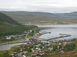
Tjeldsund (Norwegian) or Dielddanuorri (Northern Sami) is a municipality in Troms county, Norway. The southwestern part of the municipality is part of the traditional district of Ofoten and the rest of the municipality is part of Central Hålogaland. The administrative centre of the municipality is the village of Evenskjer. Other important villages include Boltåsen, Fjelldal, Grov, Myklebostad, Ramsund, Renså, Sandstrand, and Tovika. Norges Brannskole is situated in Fjelldal. Marinejegerkommandoen is based south of Ramsund.

<span class="mw-page-title-main">Moskenes Municipality</span> Municipality in Nordland, Norway

Moskenes is a municipality in Nordland county, Norway. The municipality comprises the southern part of the island of Moskenesøya in the traditional district of Lofoten. The administrative centre of the municipality is the village of Reine. Other villages include Sørvågen, Hamnøya, and Å.

<span class="mw-page-title-main">Skånland Municipality</span> Former municipality in Troms, Norway

Skånland is a former municipality in Troms county, Norway. The 495-square-kilometre (191 sq mi) municipality existed from 1926 until its dissolution in 2020 when it was merged into Tjeldsund Municipality. It was part of the Central Hålogaland region, just southeast of the city of Harstad. The administrative centre of the municipality was the village of Evenskjer. Other villages included Grovfjord, Renså, Sandstrand, and Tovik.

<span class="mw-page-title-main">Gratangen Municipality</span> Municipality in Troms, Norway

Gratangen (Norwegian) or Rivtták (Northern Sami) is a municipality in Troms county, Norway. It is part of the traditional region of Central Hålogaland. The administrative centre of the municipality is the village of Årstein.

<span class="mw-page-title-main">Sørreisa Municipality</span> Municipality in Troms, Norway

Sørreisa is a municipality in Troms county, Norway. The administrative centre of the municipality is the village of Sørreisa. Other villages include Grunnreisa, Skøelva, and Smørsgård.

<span class="mw-page-title-main">Tranøy Municipality</span> Former municipality in Troms, Norway

Tranøy is a former municipality in Troms county, Norway. The municipality was situated on the southern coast of the large island of Senja. The municipality existed from 1838 until its dissolution in 2020 when it was merged into the new Senja Municipality. The administrative centre was the village of Vangsvik in the eastern part of the municipality. Other important villages included Stonglandseidet, Skrollsvika, and Å.

<span class="mw-page-title-main">Lenvik Municipality</span> Former municipality in Troms, Norway

Lenvik is a former municipality in Troms county, Norway. The municipality existed from 1838 until its dissolution in 2020. The municipality was partly situated on the mainland and partly on the island of Senja in what is now Senja Municipality. The administrative centre was the town of Finnsnes, where the Gisund Bridge connects Senja to the mainland on Norwegian County Road 86. Other villages in the municipality included Aglapsvik, Gibostad, Botnhamn, Fjordgård, Finnfjordbotn, Husøy, Langnes, Laukhella, Silsand, and Rossfjordstraumen.

<span class="mw-page-title-main">Nordreisa Municipality</span> Municipality in Troms, Norway

Nordreisa (Norwegian), Ráisa, or Raisi (Kven) is a municipality in Troms county, Norway. The administrative centre of the municipality is the village of Storslett. Other villages include Oksfjordhamn, Sørkjosen, and Rotsund.

<span class="mw-page-title-main">Kvænangen Municipality</span> Municipality in Troms, Norway

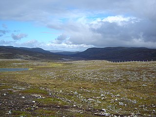
Kvænangen is a municipality in Troms county, Norway. The administrative centre of the municipality is the village of Burfjord. Other notable villages in the municipality include Alteidet, Badderen, Kjækan, and Sekkemo. The European route E6 highway goes through the municipality and over the Sørstraumen Bridge, and many people stop at the Kvænangsfjellet pass to view the scenery of the Kvænangen fjord.

<span class="mw-page-title-main">Hammerfest Municipality</span> Municipality in Finnmark, Norway

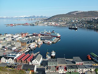
Hammerfest is a municipality in Finnmark county, Norway. The administrative centre of the municipality being the town of Hammerfest which is considered the northernmost town in the world with more than 5,000 inhabitants. Some of the main villages in the municipality include Rypefjord, Kvalsund, Forsøl, Hønsebybotn, Akkarfjord i Kvaløya, Akkarfjord i Sørøya, and Kårhamn.

<span class="mw-page-title-main">Sørøysund Municipality</span> Former municipality in Finnmark, Norway

Sørøysund is a former municipality in Finnmark county, Norway. The 826-square-kilometre (319 sq mi) municipality existed from 1852 until its dissolution in 1992. The area is now part of Hammerfest Municipality. The administrative centre of Sørøysund was the town of Hammerfest, even though the town was not part of Sørøysund Municipality. Notable villages in the municipality included Akkarfjord, Forsøl, Kårhamn, and Rypefjord.

References

  1. 1 2 "Høgaste fjelltopp i kvar kommune" (in Norwegian). Kartverket. 16 January 2024. Archived from the original on 12 March 2019.
  2. "Navn på steder og personer: Innbyggjarnamn" (in Norwegian). Språkrådet.
  3. "Forskrift om målvedtak i kommunar og fylkeskommunar" (in Norwegian). Lovdata.no.
  4. Bolstad, Erik; Thorsnæs, Geir, eds. (26 January 2023). "Kommunenummer". Store norske leksikon (in Norwegian). Kunnskapsforlaget.
  5. Statistisk sentralbyrå. "Table: 06913: Population 1 January and population changes during the calendar year (M)" (in Norwegian).
  6. Statistisk sentralbyrå. "09280: Area of land and fresh water (km²) (M)" (in Norwegian).
  7. Ytreberg, Rune (12 September 2015). "Dette er ikke en lek". Dagens Næringsliv. p. 16.
  8. Jukvam, Dag (1999). Historisk oversikt over endringer i kommune- og fylkesinndelingen (PDF) (in Norwegian). Statistisk sentralbyrå. ISBN   9788253746845.
  9. "Om sammenslåingen" (in Norwegian). Nye Hammerfest kommune. Archived from the original on 18 June 2018. Retrieved 18 June 2018.
  10. Rygh, Oluf (1924). Norske gaardnavne: Finmarkens amt (in Norwegian) (18 ed.). Kristiania, Norge: W. C. Fabritius & sønners bogtrikkeri. pp. 134 and 138.
  11. "Civic heraldry of Norway - Norske Kommunevåpen". Heraldry of the World. Retrieved 22 January 2023.
  12. "Kvalsund, Finmark (Norway)". Flags of the World. Retrieved 22 January 2023.
  13. "Godkjenning av våpen og flagg". Lovdata.no (in Norwegian). Norges kommunal- og arbeidsdepartementet. 27 March 1987. Retrieved 22 January 2023.
  14. Hansen, Tore; Vabo, Signy Irene, eds. (20 September 2022). "kommunestyre". Store norske leksikon (in Norwegian). Kunnskapsforlaget . Retrieved 3 August 2023.
  15. 1 2 3 4 "Table: 04813: Members of the local councils, by party/electoral list at the Municipal Council election (M)" (in Norwegian). Statistics Norway.
  16. "Tall for Norge: Kommunestyrevalg 2011 - Finnmark". Valg Direktoratet. Retrieved 23 October 2019.
  17. "Kommunestyrevalget 1995" (PDF) (in Norwegian). Oslo-Kongsvinger: Statistisk sentralbyrå. 1996. Retrieved 20 February 2020.
  18. "Kommunestyrevalget 1991" (PDF) (in Norwegian). Oslo-Kongsvinger: Statistisk sentralbyrå. 1993. Retrieved 20 February 2020.
  19. "Kommunestyrevalget 1987" (PDF) (in Norwegian). Oslo-Kongsvinger: Statistisk sentralbyrå. 1988. Retrieved 20 February 2020.
  20. "Kommunestyrevalget 1983" (PDF) (in Norwegian). Oslo-Kongsvinger: Statistisk sentralbyrå. 1984. Retrieved 20 February 2020.
  21. "Kommunestyrevalget 1979" (PDF) (in Norwegian). Oslo: Statistisk sentralbyrå. 1979. Retrieved 20 February 2020.
  22. "Kommunevalgene 1975" (PDF) (in Norwegian). Oslo: Statistisk sentralbyrå. 1977. Retrieved 16 March 2020.
  23. "Kommunevalgene 1972" (PDF) (in Norwegian). Oslo: Statistisk sentralbyrå. 1973. Retrieved 16 March 2020.
  24. "Kommunevalgene 1967" (PDF) (in Norwegian). Oslo: Statistisk sentralbyrå. 1967. Retrieved 16 March 2020.
  25. "Kommunevalgene 1963" (PDF) (in Norwegian). Oslo: Statistisk sentralbyrå. 1964. Retrieved 16 March 2020.
  26. "Kommunevalgene og Ordførervalgene 1959" (PDF) (in Norwegian). Oslo: Statistisk sentralbyrå. 1960. Retrieved 16 March 2020.
  27. "Kommunevalgene og Ordførervalgene 1955" (PDF) (in Norwegian). Oslo: Statistisk sentralbyrå. 1957. Retrieved 16 March 2020.
  28. "Kommunevalgene og Ordførervalgene 1951" (PDF) (in Norwegian). Oslo: Statistisk sentralbyrå. 1952. Retrieved 16 March 2020.
  29. "Kommunevalgene og Ordførervalgene 1947" (PDF) (in Norwegian). Oslo: Statistisk sentralbyrå. 1948. Retrieved 16 March 2020.
  30. "Kommunevalgene og Ordførervalgene 1945" (PDF) (in Norwegian). Oslo: Statistisk sentralbyrå. 1947. Retrieved 16 March 2020.
  31. "Kommunevalgene og Ordførervalgene 1937" (PDF) (in Norwegian). Oslo: Statistisk sentralbyrå. 1938. Retrieved 16 March 2020.
  32. Sundt, Eilert (5 July 2019). "Ordførergalleri". Hammerfest kommune (in Norwegian). Retrieved 25 March 2023.
  33. "Climate Summary". Weatherbase.com. Retrieved 25 March 2023.
  34. "Climate and Average Weather Year Round". weatherspark.com. Retrieved 25 March 2023.
  35. "Monthly - Weather averages summary". weatherbase.com. Retrieved 25 March 2023.
  36. "Climate and monthly weather forecast". weather-atlas.com. Retrieved 25 March 2023.