The Chipewyan are a Dene Indigenous Canadian people of the Athabaskan language family, whose ancestors are identified with the Taltheilei Shale archaeological tradition. They are part of the Northern Athabascan group of peoples, and hail from what is now Western Canada.
Peter Pond was an American explorer, cartographer, merchant and soldier who was a founding member of the North West Company and the Beaver Club. Though he was born and died in Milford, Connecticut, most of his life was spent in northwestern North America, on the upper Mississippi and in western Canada.
Patuanak is a community in northern Saskatchewan, Canada. It is the administrative headquarters of the Dene First Nations reserve near Churchill River and the north end of Lac Île-à-la-Crosse. In Dene, it sounds similar to Boni Cheri (Bëghą́nı̨ch’ërë).

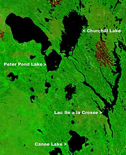
Beaver River is a large river in east-central Alberta and central Saskatchewan, Canada. It flows east through Alberta and Saskatchewan and then turns sharply north to flow into Lac Île-à-la-Crosse on the Churchill River which flows into Hudson Bay.
Highway 918 is a provincial highway in the north-west and far north regions of the Canadian province of Saskatchewan. It runs from Highway 165 near Beauval to Patuanak. The highway follows the Beaver River, runs along the eastern shore of Lac Île-à-la-Crosse, and provides access to Patuanak Airport. It is about 92 kilometres (57 mi) long.
Highway 155 is a paved, undivided provincial highway in the Canadian province of Saskatchewan. It runs from Highway 55 near Green Lake until La Loche, where it intersects with Highway 955. The highway services several communities and provincial recreation sites and is entirely within the Northern Saskatchewan Administration District. It is about 299 kilometres (186 mi) long.
The Sakāwithiniwak or Woodland Cree, are a Cree people, calling themselves Nîhithaw in their own dialect of the language. They are the largest indigenous group in northern Alberta and are an Algonquian people. Prior to the 18th century, their territory extended west of Hudson Bay, as far north as Churchill. Although in western Northern Saskatchewan and Manitoba, by the 18th century, they acted as middlemen in trade with western tribes. After acquiring guns through trade, they greatly expanded their territory and drove other tribes further west and north.

Moose Lake is a relatively small lake in North-eastern Alberta, Canada, which drains north into the Beaver River (Canada). It is located a few kilometres west of the town of Bonnyville. Note there is a second body of water named Moose Lake 65 km NW of Fort Mackay.
Green Lake is a northern village in Saskatchewan, Canada. Its residents are predominantly Métis people. Green Lake is located northeast of Meadow Lake, and northwest of Big River. It lies in the southern boreal forest, and takes its name from nearby Green Lake. Fishing, tourism, and farming, are the major industries.

Amisk Lake is a lake in the east-central part of the Canadian province of Saskatchewan, about 22 kilometres (14 mi) south-west of Flin Flon, Manitoba. 'Amisk' means beaver in Cree. Along the lake's shores is the community of Denare Beach, a provincial recreation site with lake access and camping, and prehistoric limestone crevices. Access to the lake and its amenities is from Highway 167. Amisk Lake was on an important fur trade route in the 18th century.

Frog Portage or Portage du Traite was one of the most important portages on the voyageur route from Eastern Canada to the Mackenzie River basin. It allowed boatmen to move from the Saskatchewan River basin to the Churchill River basin. The Churchill then led west to the Mackenzie River basin. The fur trade route ran from Cumberland House, Saskatchewan north up the Sturgeon-Weir River. At its source the 300-yard Frog Portage ran, with a 20-foot drop, to Trade Lake on the Churchill a few miles west of the mouth of Reindeer River. The route then ran at least 250 miles northwest up the Churchill to Methye Portage which led to the Mackenzie basin.
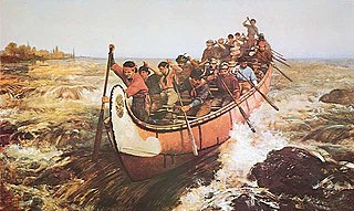
Voyageurs were 18th- and 19th-century French Canadians who transported furs by canoe at the peak of the North American fur trade. The emblematic meaning of the term applies to places and times where that transportation was over long distances. The voyageurs' strength and endurance was regarded as legendary. They were celebrated in folklore and music. For reasons of promised celebrity status and wealth, this position was coveted.
Louis Primeau or Primo was one of the first European fur traders on the Churchill River. Primeau Lake in northern Saskatchewan, Canada is named after him. Little is known of his youth. Morton says that he was born in Quebec of an English father and French mother, but the DCB does not repeat this.

Saskatchewan River fur trade The Saskatchewan River was one of the two main axes of Canadian expansion west of Lake Winnipeg. The other and more important one was northwest to the Athabasca Country. For background see Canadian canoe routes (early). The main trade route followed the North Saskatchewan River and Saskatchewan River, which were just south of the forested beaver country. The South Saskatchewan River was a prairie river with few furs.
Fur trading on the Assiniboine River and the general area west of Lake Winnipeg, in what is now Manitoba, Canada, began as early as 1731.

The Pemmican War was a series of armed confrontations during the North American fur trade between the Hudson's Bay Company (HBC) and the North West Company (NWC) in the years following the establishment of the Red River Colony in 1812 by Lord Selkirk. It ended in 1821 when the NWC merged with the HBC.

The English River Dene Nation is a Dene First Nation band government in Patuanak, Saskatchewan, Canada. Their reserve is in the northern section of the province. Its territories are in the boreal forest of the Canadian Shield. This First Nation is a member of the Meadow Lake Tribal Council (MLTC).

Cold River is a river in the Canadian province of Saskatchewan. The river's source is Cold Lake, which is a large lake on the provincial border of Saskatchewan and Alberta, and its mouth is at the western end of Lac des Îles in Meadow Lake Provincial Park. It is an east flowing river and the entirety of its course is in Meadow Lake Provincial Park and the boreal forest.

Martineau River is a river in the Canadian provinces of Saskatchewan and Alberta. Its source is at Primrose Lake in north-western Saskatchewan and its mouth is at Cold Lake in Alberta. The river travels in a south-westerly direction through muskeg and the boreal forest ecozone of Canada The majority of the river and its tributaries are in Saskatchewan with only the final leg being in Alberta.
Lac des Îles is a lake in Meadow Lake Provincial Park in the Canadian Province of Saskatchewan in the boreal forest ecozone of Canada. The primary inflow is the Cold River and its outflow is the Waterhen River. The lake and associated rivers are part of the Hudson Bay drainage basin as the Waterhen River flows into Beaver River, which meets the Churchill River, a major river that flows into Hudson Bay, at Lac Île-à-la-Crosse.