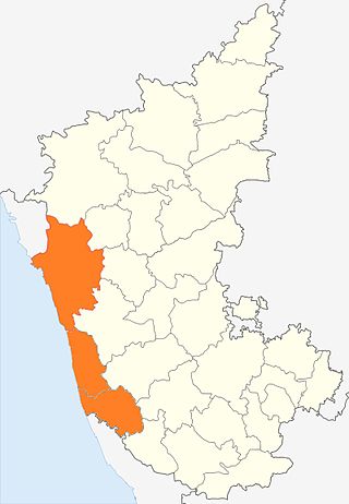
Kanara or Canara, also known as Karavali is the historically significant stretch of land situated by the southwestern coast of India, alongside the Arabian Sea in the present-day Indian state of Karnataka. The subregion comprises three civil districts, namely: Uttara Kannada, Udupi, and Dakshina Kannada. Kassergode was included prior to the States Reorganisation Act.

Dakshina Kannada district is located in the state of Karnataka in India, with its headquarters in the coastal city of Mangalore. It is part of the larger Tulu Nadu region. The district covers an area nestled in between the Western Ghats to its east and the Arabian Sea to its west. Dakshina Kannada receives abundant rainfall during the Indian monsoon. It is bordered by Udupi district to the north, Chikmagalur district to the northeast, Hassan district to the east, Kodagu to the southeast and Kasaragod district of Kerala to the south. According to the 2011 census of India, Dakshina Kannada district had a population of 2,083,625. It is the only district in Karnataka state to have all modes of transport like road, rail, water and air due to the presence of a major hub, Mangalore. This financial district is also known as the Cradle of Indian banking.
Addur is a village in the southern state of Karnataka, India. It is located in the Mangalore taluk of Dakshina Kannada district.
Ajjavara is a village in the southern Indian state of Karnataka. It is located in the Sullia taluk of Dakshina Kannada district in Karnataka.
Aletty is a village in the southern state of Karnataka, India. It is located in the Sullia taluk of Dakshina Kannada district in Karnataka.
Amtady is a village in the southern state of Karnataka, India. It is located in the Bantwal taluk of Dakshina Kannada district in Karnataka.
Aryapu (Rural) is a village in the southern state of Karnataka, India. It is located in the Puttur taluk of Dakshina Kannada district in Karnataka.
Kepu is a village in the southern state of Karnataka, India. It is located in the Bantwal taluk of Dakshina Kannada district in Karnataka.
Kodimbala is a village in the southern state of Karnataka, India. It is located in the Puttur taluk of Dakshina Kannada district in Karnataka.
Narimogru is a village in the southern state of Karnataka, India. It is located in the Puttur taluk of Dakshina Kannada district in Karnataka.
Naringana is a village in the southern state of Karnataka, India. It is located in the Bantwal taluk of Dakshina Kannada district in Karnataka.

Sampaje is a village in the southern state of Karnataka, India. It is located in the Madikeri taluk of Kodagu district in Karnataka. It lies on NH-275 which connects Mangalore city in Dakshina Kannada district with Madikeri town in Kodagu distrtict. It is a border village in between Kodagu and Dakshina kannada.
Veerakamba is a village in the southern state of Karnataka, India. It is located in the Bantwal taluk of Dakshina Kannada district in Karnataka.
Vittalpadanur is a village in the southern state of Karnataka, India. It is located in the Bantwal taluk of Dakshina Kannada district.
102 Nekkilady is a village in the southern state of Karnataka, India. It is located in the Kadaba taluk of Dakshina Kannada district.

Aithoor is a village in the southern state of Karnataka, India. It is located in the Kadaba taluk of Dakshina Kannada district in Karnataka.

Aivarnadu is a village in the southern state of Karnataka, India. It is located in the Sulya taluk of Dakshina Kannada district.

Aivathoklu is a village in the southern state of Karnataka, India. It is located in the Sulya taluk of Dakshina Kannada district in Karnataka.

Ajjibettu is a village in the southern state of Karnataka, India. It is located in the Bantval taluk of Dakshina Kannada district.

Moodabidri Assembly constituency is one of the 224 Legislative Assembly constituencies of Karnataka state in India.


