Lake Roxburgh is an artificial lake, created by the Roxburgh Dam, the earliest of the large hydroelectric projects in the southern South Island of New Zealand. It lies on the Clutha River, some 160 km (99 mi) from Dunedin. It covers an area of some 6 km2 (2.3 sq mi), and extends for nearly 30 km (19 mi) towards the town of Alexandra. The town of Roxburgh lies 5 kilometres (3.1 mi) south of the Dam.
Kingston is a small town at the southernmost end of Lake Wakatipu, just north of the border of Otago and Southland, in New Zealand's South Island. It is 47 kilometres south of Queenstown by a road, "The Devil's Staircase", which winds between the lake to the west and The Remarkables mountains to the east. It is 70 kilometres north of Lumsden, and close to the headwaters of the Mataura River.

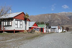
Otematata is a town in the Waitaki District of Otago in New Zealand's South Island. It is defined as a "populated area less than a town" and the 2001 New Zealand census gave the "usually resident population count" as 243. By the 2018 census it had declined to 183 inhabitants. This was considerably higher in the 1960s during the construction of the Benmore and Aviemore dams.
Ashburton Forks, formerly known as Spreadeagle, is a defined locality on the Canterbury Plains between the forks of the Ashburton / Hakatere Rivers and within the Ashburton District of the Canterbury Province of New Zealand's South Island. It is approximately 50 km west of Ashburton and about 17 km from the foot of the Southern Alps.

Moana is a small town in the West Coast Region of the South Island of New Zealand. It is situated on the northern shore of Lake Brunner, and is beside the outflow of the lake into the Arnold River. There is a pedestrian suspension bridge crossing the Arnold from the town to access the lake shore across the river, with some short easy bush walks on each side.
Spencerville is a semi-rural town on the east coast of Canterbury, New Zealand north of Christchurch. The town backs on to Bottle Lake Forest and includes a large park and 80 hectare camping ground. These amenities, as well as wetlands and an animal and bird park make the town a popular camping area for Christchurch residents.

Eiffelton is a lightly populated locality in the Mid-Canterbury region of New Zealand's South Island.

Dunsandel is a small rural town in the Canterbury region of the South Island, New Zealand. The town is located on the Canterbury Plains just south of the Selwyn River / Waikirikiri and about 40 km south of Christchurch. Dunsandel is a junction town on SH1, halfway between Christchurch and Ashburton, with roads leading to Leeston, Southbridge and Hororata. The town provides an important refreshment stop for main road travellers with eateries and coffee shops, as well as acting as a support town for the rural hinterland.

Taupiri is a small town of about 500 people on the eastern bank of the Waikato River in the Waikato District of New Zealand. It is overlooked by Taupiri mountain, the sacred burial ground for the Waikato tribes of the Māori people, located just to the north.

Wharewaka is a suburb of Taupō, New Zealand. It stretches from Rainbow Point to Five Mile Bay on the west side of State Highway 1. Wharewaka lies on a small point of land next to Lake Taupō and 1.6 km northwest of the Taupō Airport.
Tutira is a village to the north of Napier and is part of the Hawke's Bay Region in New Zealand's North Island. It is located on State Highway 2 between Wairoa and Napier.
Orari is a small town in the South Canterbury region of New Zealand's South Island, roughly midway between Ashburton to the north, and Timaru to the south it is the northernmost town of South Canterbury.

Ashburton District is a territorial authority district in the Canterbury Region of the South Island of New Zealand. It encompasses the town of Ashburton, a number of small towns and settlements and the surrounding rural area, roughly coterminous with Mid Canterbury. The district had a population of 36,800 as of June 2023.

Anakiwa is a coastal residential village in the Marlborough region of New Zealand. It sits at the head of Queen Charlotte Sound/Tōtaranui, one of the Marlborough Sounds, 23 km (14 mi) west of Picton and 18 km (11 mi) east of Havelock. At the 2018 census, the village had a usual resident population of 171.

Ashley is a small town in North Canterbury, in the South Island of New Zealand. It used to have a railway station on the Main North Line that runs through the village.
Tai Tapu, previously known as Taitapu, is a small town adjacent to the Halswell River and nestled in the Port Hills, located 6 km east of the town of Lincoln and 18 km south west of Christchurch in the Canterbury region of New Zealand's South Island. State Highway 75 passes through the centre of the village, connecting Christchurch with Akaroa and the Banks Peninsula.
Karapiro is a settlement and rural area in the Waipa District and Waikato region of New Zealand's North Island. It includes both the artificially created Lake Karapiro and the accompanying Karapiro Power Station. Karapiro is located just off State Highway 1, south-west of Cambridge.

Ashburton Central is the central suburb and central business district of Ashburton, in the Ashburton District and Canterbury Region of New Zealand's South Island.
Forest Lakes is a rural locality in the Kāpiti Coast District of the Wellington Region of New Zealand's North Island. It is located between Ōtaki and the northern boundary of Kāpiti Coast. Forest Lakes Road runs west from State Highway 1. The area contains Lake Waitawa, Ngatotara Lagoon, and several smaller lakes. Lake Kopureherehere is just north of the district border.

Motukarara is a locality to the northeast of Lake Ellesmere / Te Waihora in the Selwyn District of New Zealand. State Highway 75 passes through the centre of the village, connecting Christchurch with Akaroa and the Banks Peninsula. The Little River Branch, which operated between 1886 and 1962, ran through Motukarara, and is now a shared walkway and cycleway.