Lanesboro, Pennsylvania | |
---|---|
Coordinates: 41°57′48″N75°34′55″W / 41.96333°N 75.58194°W | |
Country | United States |
State | Pennsylvania |
County | Susquehanna |
Established | 1888 |
Government | |
• Mayor | Chris Maby |
Area | |
• Total | 2.68 sq mi (6.95 km2) |
• Land | 2.62 sq mi (6.78 km2) |
• Water | 0.06 sq mi (0.17 km2) |
Population | |
• Total | 508 |
• Density | 194.12/sq mi (74.94/km2) |
Time zone | UTC-5 (EST) |
• Summer (DST) | UTC-4 (EDT) |
Zip Code | 18827, 18847 |
Area code | 570 |
FIPS code | 42-41336 |
Website | lanesboropa |
Lanesboro is a borough in Susquehanna County, Pennsylvania, United States. The population was 485 at the 2020 census. [3]
Lanesboro was named for Martin Lane, an early settler [4] who first called it Lanesville. The name was changed to Lanesboro by his son Jesse Lane. Lanesboro was incorporated as a borough in 1889. [5]
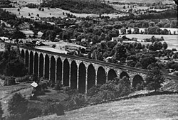
The Starrucca Viaduct was added to the National Register of Historic Places in 1975. [6]
Lanesboro is located at 41°57′48″N75°34′55″W / 41.96333°N 75.58194°W (41.963293, -75.582034). [7]
According to the United States Census Bureau, the borough has a total area of 2.66 square miles (6.9 km2), of which 2.6 square miles (6.7 km2) is land and 0.06 square miles (0.16 km2) (2.26%) is water.
Census | Pop. | Note | %± |
---|---|---|---|
1880 | 348 | — | |
1890 | 876 | 151.7% | |
1900 | 821 | −6.3% | |
1910 | 771 | −6.1% | |
1920 | 805 | 4.4% | |
1930 | 731 | −9.2% | |
1940 | 637 | −12.9% | |
1950 | 591 | −7.2% | |
1960 | 502 | −15.1% | |
1970 | 550 | 9.6% | |
1980 | 465 | −15.5% | |
1990 | 659 | 41.7% | |
2000 | 588 | −10.8% | |
2010 | 506 | −13.9% | |
2020 | 485 | −4.2% | |
2021 (est.) | 482 | [3] | −0.6% |
Sources: [8] [9] [10] [2] |
At the 2000 census there were 588 people, 248 households, and 149 families living in the borough. The population density was 230.6 inhabitants per square mile (89.0/km2). There were 278 housing units at an average density of 109.0 per square mile (42.1/km2). The racial makeup of the borough was 97.79% White, 0.17% Native American, 1.53% Asian, 0.17% Pacific Islander, and 0.34% from two or more races. Hispanic or Latino of any race were 0.68%. [9]
Of the 248 households 29.8% had children under the age of 18 living with them, 45.2% were married couples living together, 8.9% had a female householder with no husband present, and 39.9% were non-families. 33.9% of households were one person and 25.0% were one person aged 65 or older. The average household size was 2.37 and the average family size was 3.04.
The age distribution was 25.7% under the age of 18, 5.3% from 18 to 24, 24.5% from 25 to 44, 24.3% from 45 to 64, and 20.2% 65 or older. The median age was 42 years. For every 100 females, there were 80.4 males. For every 100 females age 18 and over, there were 75.5 males.
The median household income was $27,727 and the median family income was $34,844. Males had a median income of $30,750 versus $20,577 for females. The per capita income for the borough was $13,873. About 9.7% of families and 19.5% of the population were below the poverty line, including 17.3% of those under age 18 and 28.3% of those age 65 or over.
At the 2010 census there were 506 people, 217 households, and 122 families living in the borough. The population density was 194.6 inhabitants per square mile (75.1/km2). There were 243 housing units at an average density of 93.5 per square mile (36.1/km2). The racial makeup of the borough was 96.4% White, 0.4% Black or African American, 0.4% Native American, 0.4% Asian, and 2.4% from two or more races. [11] Of the 217 households 26.7% had children under the age of 18 living with them, 37.8% were married couples living together, 13.4% had a female householder with no husband present, and 43.8% were non-families. 36.9% of households were one person and 24.9% were one person aged 65 or older. The average household size was 2.33 and the average family size was 3.02.
The age distribution was 25.7% under the age of 18, 53.7% from 18 to 64, and 20.6% 65 or older. The median age was 42.5 years.
The median household income was $29,083 and the median family income was $35,179. Males had a median income of $31,141 versus $28,409 for females. The per capita income for the borough was $16,319. About 25.2% of families and 19.6% of the population were below the poverty line, including 16.5% of those under age 18 and 40.9% of those age 65 or over.
Lakeland Highlands is an unincorporated community and census-designated place (CDP) in Polk County, Florida, United States. The population was 11,056 at the 2010 census. It is part of the Lakeland–Winter Haven Metropolitan Statistical Area. It is an affluent residential community located south of the Lakeland city limits, and north of the Mulberry city limits. Lakeland Highlands neighbors Medulla, and together the two communities make up much of what is known as South Lakeland (unincorporated).
Lanesboro is a city in Carroll County, Iowa, United States. The population was 119 at the time of the 2020 census.
Forest Hills is a home rule-class city in Jefferson County, Kentucky, United States. It was formally incorporated by the state assembly in 1959. The population was 444 at the 2010 census.
Aurelius Township is a civil township of Ingham County in the U.S. state of Michigan. As of the 2020 census, the township population was 4,354, a significant increase from 3,525 at the 2010 census.
Bechtelsville is a borough in Berks County, Pennsylvania, United States. The population was 884 at the 2020 census.
Modena is a borough in Chester County, Pennsylvania, United States. The population was 544 at the 2020 census. It was originally called Modeville, after the local Mode family.
Spring City is a borough in Chester County, Pennsylvania, United States. The population was 3,494 at the 2020 census. Spring City is a member of the Spring-Ford Area School District.
Dalton is a borough in Lackawanna County, Pennsylvania, United States. It is part of Northeastern Pennsylvania and is located approximately eight miles north of the city of Scranton in a suburban area known as "the Abingtons." Dalton is also approximately three miles north of Clarks Summit, the hub of the Abington community. The population was 1,283 at the 2020 census.
Jessup is a borough in Lackawanna County, Pennsylvania, United States. The population was 4,532 at the 2020 census.
Mayfield is a borough in Lackawanna County, Pennsylvania, United States, approximately 14 miles (23 km) northeast of Scranton. In the past, it contained a silk mill and a coal mining industry. The population was 1,763 at the 2020 census.
Bear Creek Village is a borough in Luzerne County, Pennsylvania, United States. The population was 290 at the 2020 census.
Courtdale is a borough in Luzerne County, Pennsylvania, United States. The population was 689 at the 2020 census.
Edwardsville is a borough in Luzerne County, Pennsylvania, United States. The population was 4,918 at the 2020 census.
Yatesville is a borough in the Greater Pittston area of Luzerne County, Pennsylvania. The population was 638 as of the 2020 census.
East Bangor is a borough in Northampton County, Pennsylvania, US, with a population of 1,124 at the 2020 census. It is in the Lehigh Valley metropolitan region, which had a population of 861,899 and was the 68th-most populous metropolitan area in the U.S. as of the 2020 census.
Oakland is a borough in Susquehanna County, Pennsylvania, United States. The population of Oakland borough was 564 at the 2020 census.
Union Dale is a borough in Susquehanna County, Pennsylvania, United States. The borough was incorporated in 1885. Union Dale's population was 267 at the 2010 census.
Waymart is a borough in Wayne County, Pennsylvania, United States. Waymart is a small town in the Pocono Mountains of Pennsylvania known for its railroading history, Coal Country roots, and outdoor recreation. The borough's population was 1,341 at the time of the 2010 United States Census.
Edcouch is a city in Hidalgo County, Texas, United States. The population was 3,161 at the 2010 census. It is part of the McAllen–Edinburg–Mission and Reynosa–McAllen metropolitan areas. The town was founded in 1927 and named for Edward Couch, landowner and banker.
Poplar is a village in Douglas County, Wisconsin, United States. The population was 629 at the 2020 census up from 603 at the 2010 census.