Lion's Den | |
---|---|
Coordinates: 17°16′12″S30°01′30″E / 17.27000°S 30.02500°E Coordinates: 17°16′12″S30°01′30″E / 17.27000°S 30.02500°E | |
Country | Zimbabwe |
Province | Mashonaland West |
District | Makonde District |
City | Lion's Den Municipality |
Elevation | 1,151 m (3,776 ft) |
Population (2011 Estimate) | |
• Total | Less than 1,000 |
Time zone | CAT (UTC+2) |
Climate | Cwa |
Lion's Den is a small town in Zimbabwe.
The town lies in Makonde District, Mashonaland West Province, in central northern Zimbabwe. It is located about 25 kilometres (16 mi), northwest of Chinhoyi, the nearest large town, and the location of the district and provincial headquarters. [1] This location is approximately 150 kilometres (93 mi), by road, northwest of Harare, the capital of Zimbabwe, and the largest city in that country. [2] Lion's Den sits on Highway A-1, the main road from Harare to Chirundu, at the International border with Zambia, about 230 kilometres (140 mi), further northwest from Lion's Den. [3] The coordinates of the town are: Latitude:-17.2700; Longitude:30.0250 (17° 16' 12.00"S, 30° 1' 30.00"E). The town sits at an altitude of 3,776 feet (1,151 m), above sea level. [4]
Makonde District is a district in Zimbabwe.
Zimbabwe, officially the Republic of Zimbabwe, is a landlocked country located in southern Africa, between the Zambezi and Limpopo Rivers, bordered by South Africa, Botswana, Zambia and Mozambique. The capital and largest city is Harare. A country of roughly 16 million people, Zimbabwe has 16 official languages, with English, Shona, and Ndebele the most commonly used.
Chinhoyi, known until 1982 as Sinoia, is a town in Zimbabwe.
Lion's Den is a small farming town. Crops raised in the surrounding countryside include cotton, maize and tobacco. In addition, cattle is raised on a commercial basis for milk and beef.
The current population of Lion's Den is not publicly known. In 2011, the population in the town was estimated at less than 1,000 people. [5] The next national population census in Zimbabwe is scheduled from 18 August 2012 through 28 August 2012. [6]
The Republic of Zimbabwe is broken down into 10 administrative Provinces, which are divided into 59 Districts and 1,200 Wards. The districts are listed below, alphabetically:
Provinces are constituent political entities of Zimbabwe. Zimbabwe currently has ten provinces, two of which are cities with provincial status. Zimbabwe is a unitary state, and its provinces exercise only the powers that the central government chooses to delegate. Provinces are divided into districts, which are divided into wards.
The economy of Zimbabwe shrunk significantly after 2000, resulting in a desperate situation for the country – widespread poverty and a 95% unemployment rate. Zimbabwe's participation from 1998 to 2002 in the war in the Democratic Republic of the Congo set the stage for this deterioration by draining the country of hundreds of millions of dollars. Hyperinflation in Zimbabwe was a major problem from about 2003 to April 2009, when the country suspended its own currency. Zimbabwe faced 231 million percent peak hyperinflation in 2008. A combination of the abandonment of the Zimbabwe dollar and a government of national unity in 2009 resulted in a period of positive economic growth for the first time in a decade.
Nyanga is a town in Zimbabwe. At one time, the town was known as Inyanga.
The Chinhoyi Caves are a group of limestone and dolomite caves in north central Zimbabwe. Since 1955 they are designated as a National Park and managed by the Zimbabwe Parks & Wildlife Management Authority.
Alaska is a small town in central northern Zimbabwe in Makonde District, Mashonaland West Province.
Sanyati is a town in Zimbabwe.
For the Dion Boucicault play, please see The Colleen Bawn
Plumtree is a small town in Zimbabwe. Alongside marula trees, wild plum trees grew abundantly in the area, hence the name Plumtree.
Kadoma, formerly known as Gatooma, is a town in Zimbabwe.
Makoni District is a district in Zimbabwe. The name also refers to a parliamentary constituency with coterminous borders.
Karoi is a town in Zimbabwe.
Chimanimani is a town in Zimbabwe.
Murombedzi is a town in Zimbabwe.
Kadoma District is a district in Zimbabwe.
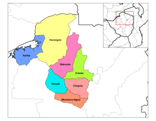
Karoi District is a district of Mashonaland West Province, Zimbabwe. The district is also known as Hurungwe District.
Zvimba District is a district of Mashonaland West Province, Zimbabwe.
Murambinda is a town in Zimbabwe.
Murambinda Mission Hospital (MMH), is a hospital in Zimbabwe. The hospital, also known as Murambinda Hospital, is located in the town of Murambinda, Buhera District, Manicaland Province, in eastern Zimbabwe. Its location is approximately 30 kilometres (19 mi), by road, northeast of the village of Buhera, where the district headquarters are located. This location lies approximately 140 kilometres (87 mi), by road, southwest of the city of Mutare (pop:184,205), the location of the provincial headquarters.
R3 Highway is a primary road in Zimbabwe from the capital city Harare to Chirundu.
Chirundu-Beitbridge Road Corridor is a Trans-African Highway Network Zimbabwean link between South Africa and Zambia. It is also part of the North–South Corridor Project.