List of Inland Ferries in British Columbia

Last updated

This list details the privately operated ferry routes traversing lakes and rivers of inland British Columbia, Canada. This list does not include coastal routes operated by BC Ferries and/or its subcontractors.

Contents

List of current routes

The current inland ferries in BC are as follows: [1]

Route NameRoute DetailsVessel Name(s)Vessel Type(s)Vehicle CapacityPassenger CapacityCrossing TimeOperated ByNotesReference(s)
Adams Lake Cable Ferry Crosses Adams Lake between Chase and Sorrento, off BC Highway 1. M.V. Adams Lake II Cable 10485 minutes Waterbridge Ferries Incorporated [2]
Arrow Park Cable Ferry Crosses the juncture of Upper Arrow Lake and Lower Arrow Lake southwest of Nakusp, off BC Highway 6. M.V. Arrow Park II Cable 24485 minutes Waterbridge Ferries Incorporated [3]
Barnston Island Ferry Crosses the Parsons Channel on the Fraser River between Port Kells and Barnston Island. M.V. Centurion VI (Tugboat) + Barnston Island Replacement Barge (Barge) Tugboat and Barge 5525 minutes Western Pacific Marine [4]
Big Bar Reaction Ferry Crosses the Fraser River northwest of Clinton.Vessel Unknown Reaction 21210 minutes Interior Roads Replaced by an aerial passenger tramway during icy or low water conditions. [5]
Digby Island Ferry Crosses Prince Rupert Harbour between Fairview and Digby. M.V. Digby Island Ferry Conventional1215620 minutes City of Prince Rupert [6]
François Lake Ferry Crosses François Lake between the community of François Lake (also known as Northbank) and Southbank, on BC Highway 35. M.V. François Forrester/M.V. Omineca Princess Conventional52 (M.V. François Forrester); other vessel not known.145 (M.V. François Forrester); other vessel not known.15 minutes Waterbridge Ferries Incorporated [7]
Glade Cable Ferry Crosses the Kootenay River at Tarry's, off BC Highway 3A. M.V. Glade II Cable 10483 minutes Western Pacific Marine [8]
Harrop Cable Ferry Crosses the west arm of Kootenay Lake between Longbeach and Harrop, off BC Highway 3A. M.V. Harrop II Cable 24985 minutes Western Pacific Marine [9]
Kootenay Lake Ferry Crosses Kootenay Lake between Balfour and Kootenay Bay, on BC Highway 3A. M.V. Osprey 2000/M.V. Balfour Conventional80/28250/15035 minutes Western Pacific Marine [10]
Little Fort Reaction Ferry Crosses the North Thompson River at Little Fort, off BC Highway 5.Vessel Unknown Reaction 2125 minutes Argo Road Maintenance Incorporated [11]
Lytton Reaction Ferry Crosses the Fraser River just north of Lytton, off BC Highway 12.Vessel Unknown Reaction 2185 minutes Yellowhead Road & Bridge (Nicola) Limited [12]
McLure Reaction Ferry Crosses the North Thompson River north of Kamloops, off BC Highway 5.Vessel Unknown Reaction 2125 minutes Argo Road Maintenance Incorporated No service during high water or winter freeze up. Detour via Westsyde Road. [13]
Needles Cable Ferry Crosses Lower Arrow Lake between Fauquier and Needles, on BC Highway 6. M.V. Needles Cable 401355 minutes Waterbridge Ferries Incorporated [14]
Upper Arrow Lake Ferry Crosses Upper Arrow Lake between Shelter Bay and Galena Bay at the junction of BC highways 23 and 31. M.V. Columbia Conventional8025020 minutes Waterbridge Ferries Incorporated [15]
Usk Reaction Ferry Crosses the Skeena River between north and south Usk, off BC Highway 16.Vessel Unknown Reaction 2125-7 minutes Nechacko Northcoast Contractors Replaced by an aerial passenger tramway during icy or low water conditions. [16]

List of former routes

former inland ferry routes in BC were as follows:

Route NameRoute DetailsVessel name(s)Vessel Type(s)Vehicle CapacityPassenger CapacityCrossing TimeOperated ByNotes
Agassiz-Rosedale Ferry Crossed the Fraser River between Agassiz and Rosedale. M.V. T'Lagunna/M.V. Eena Conventional18 (M.V. T'Lagunna)100 (M.V. T'Lagunna)Unknown.UnknownReplaced by the Agassiz-Rosedale Bridge in 1956.
Albion Ferry Crossed the Fraser River between Albion and Fort Langley. M.V. T'Lagunna/M.V. Kulleet/M.V. Klatawa Conventional26 (M.V. Kulleet/M.V. Klatawa ). 18 (M.V. T'Lagunna)150 (M.V. Kulleet/M.V. Klatawa) . 100 ( M.V. T'Lagunna).Unknown. Fraser River Marine Transportation Limited (Owned by TransLink, formerly known as the Greater Vancouver Transit Authority, and originally operated the Ministry of Highways).Replaced by the Golden Ears Bridge in 2009.
Alexandria Ferry Crossed the Fraser River at Alexandria, south of Quesnel.UnknownUnknownVehicle capacity not known.Passenger capacity not known.UnknownUnknownNot to be confused with the bridges north of Hope. [17]
Birch Island Ferry Crossed the North Thompson River at Birch Island, east of Clearwater.UnknownUnknownVehicle capacity not known.Passenger capacity not known.UnknownUnknown [17]
Blackpool Ferry Crossed the North Thompson River at Blackpool, south of Clearwater.UnknownUnknownVehicle capacity not known.Passenger capacity not known.UnknownUnknown [17]
Braeside Ferry Crossed the Nechako River at Braeside, east of Vanderhoof.UnknownUnknownVehicle capacity not known.Passenger capacity not known.UnknownUnknown [17]
Castlegar Ferry Crossed the Columbia River between Castlegar and Robson.Unknown Cable Vehicle capacity not known.Passenger capacity not known.Unknown Government of British Columbia Operated from 1910 until the opening of the Robson Bridge in the 1990s. It's northern landing is now the Lion's Head boat launch. [18]
Cedarvale Ferry Crossed the Skeena River at Cedarvale, to the southwest of Kitwanga.UnknownUnknown2 cars or a single pick-up truck.Passenger capacity not known.UnknownUnknownService ended in 1975. No replacement bridge was constructed. [17]
Chilliwack-Harrison Ferry Navigated the Fraser and Harrison Rivers between an area near Chilliwack and Harrison Hot Springs.UnknownUnknownVehicle capacity not known.Passenger capacity not known.UnknownPossibly subsidized by the Government of British Columbia [17]
Chinook Cove Ferry Crossed the North Thompson River at Chinook Cove, north of Barriere.UnknownUnknownVehicle capacity not known.Passenger capacity not known.UnknownUnknown [17]
Clayhurst Ferry Crossed the Peace River near Clayhurst.UnknownUnknownVehicle capacity not known.Passenger capacity not known.UnknownUnknownReplaced by bridge. [17]
Copper City Ferry Crossed the Skeena River at Copper City.UnknownUnknownVehicle capacity not known.Passenger capacity not known.UnknownUnknown [17]
Dunster Ferry Crossed the Fraser River at Dunster.UnknownUnknownVehicle capacity not known.Passenger capacity not known.UnknownUnknownDate of cessation of service unknown. Bridge in place today. [17]
Fort St. James Ferry Crossed the Stuart River near Fort St. James.UnknownUnknownVehicle capacity not known.Passenger capacity not known.UnknownUnknown [17]
Goldstream Ferry Crossed the Columbia River at Lake Revelstoke, likely near the mouth of the Goldstream River, north of Revelstoke.UnknownUnknownVehicle capacity not known.Passenger capacity not known.UnknownUnknownDate of cessation of service unknown. Not replaced. [17]
Gravelle (Gravel's) Ferry Crossed the Quesnel River about 21 km southeast of Quesnel.UnknownUnknownVehicle capacity not known.Passenger capacity not known.UnknownUnknown
Hall's Landing Ferry Crossed the Columbia River 3 Miles north of Arrowhead.UnknownUnknownVehicle capacity not known.Passenger capacity not known.UnknownUnknownDate of cessation of service unknown. Could be an earlier 24 Mile Ferry. [17]
Hazelton Ferry Crossed the Skeena River at Hazelton.UnknownUnknownVehicle capacity not known.Passenger capacity not known.UnknownUnknown [17]
Herrling Island Ferry Crossed the Fraser River between a location near Agassiz and Herrling Island.Unknown Cable Vehicle capacity not known.Passenger capacity not known.UnknownUnknownDate of cessation of service unknown. Not replaced. [19]
Hulatt Ferry Likely crossed the Nechako River at Hulatt east of Vanderhoof.UnknownUnknownVehicle capacity not known.Passenger capacity not known.UnknownUnknownDate of cessation of service unknown. Not replaced. [17]
Isle Pierre Ferry Crossed the Nechako River at Isle Pierre, west of Prince George.UnknownUnknownVehicle capacity not known.Passenger capacity not known.UnknownUnknownService ended around 1983. [17]
Kitwanga Ferry Crossed the Skeena River at Kitwanga.UnknownUnknownVehicle capacity not known.Passenger capacity not known.UnknownUnknown [17]
Ladner Ferry Crossed the Fraser River between Ladner and Richmond. M.V. Delta Princess Conventional3520010 minutes Government of British Columbia Replaced by the George Massey Tunnel in 1959.
Lewis Ferry Crossed the Kootenay River at Lewis, northwest of Creston.UnknownUnknownVehicle capacity not known.Passenger capacity not known.UnknownUnknownDate of cessation of service unknown. Not replaced. [17]
Marguerite/Macalister Ferry Crossed the Fraser River near Marguerite.UnknownUnknownVehicle capacity not known.Passenger capacity not known.5 minutes [20] Government of British Columbia Macalister renamed Marguerite in the 1960s. Serviced ended around 2003 to the dismay of residents. [17]
McBride Ferry Crossed the Fraser River at McBride.UnknownUnknownVehicle capacity not known.Passenger capacity not known.UnknownUnknownReplaced by a bridge. [17]
Miller's Ferry Crossed the Fraser River at Lillooet, connecting the Cariboo Road.Unknown Cable Vehicle capacity not known.Passenger capacity not known.UnknownUnknownReplaced by a truss bridge in 1888.
Mission-Matsqui Ferry Ferry Crossed the Fraser River between Mission and Matsqui.UnknownUnknownVehicle capacity not known.Passenger capacity not known.UnknownUnknownReplaced by road/rail bridge. [17]
Miworth/No. 3 IR Ferry Crossed the Nechako River at Miworth, west of Prince George.UnknownUnknownVehicle capacity not known.Passenger capacity not known.UnknownUnknownService ended in the 1940s. [17]
Monte Creek Ferry Crossed the South Thompson River at Monte Creek.UnknownUnknownVehicle capacity not known.Passenger capacity not known.UnknownUnknown [17]
New Westminster-Brownsville Ferry Crossed the Fraser River between New Westminster and Brownsville (also known as South Westminster), in what is now Surrey. M.V. K de K Conventional [21] None carriedPassenger capacity not known.UnknownUnknownReplaced by the New Westminster Railway Bridge. Operated from 1882. [22]
North Bend Aerial Ferry Crossed the Fraser River between Boston Bar and North Bend.Unknown Aerial tramway 1Passenger capacity not known.UnknownUnknownReplaced by the Cog Harrington Bridge in 1986.
Okanagan Lake Ferry Crossed Okanagan Lake between Kelowna and Westbank. M.V. Lequime/M.V. Lloyd-Jones/M.V. Pendozi/Conventional30 ( M.V. Pendozi ); others not known.325 ( M.V. Lequime ); others not known.Unknown Government of British Columbia Replaced by the Okanagan Lake Bridge in 1958.
Pacific Ferry Crossed the Skeena River at Pacific, located between Usk and Cedarvale.UnknownUnknownVehicle capacity not known.Passenger capacity not known.UnknownUnknown [17]
Pavilion Aerial Ferry Crossed the Fraser River between Pavilion and West Pavilion.Unknown Aerial tramway Vehicle capacity not known.Passenger capacity not known.UnknownUnknownCurrently not in use.
Pitt River Ferry Crossed the Pitt River between Pitt Meadows and what is now Port Coquitlam.Vessel UnknownConventional - Gasoline Engine [23] Vehicle capacity not known.Passenger capacity not known.Unknown. George Mouldey with subsidies from the Government of British Columbia. [24] [25] Ran from 27 September 1902 [26] until March 1915. [27] Replaced by the first Pitt River Bridge.
Pritchard Ferry Crossed the South Thompson River at Pritchard.UnknownUnknownVehicle capacity not known.Passenger capacity not known.UnknownUnknownReplaced by a bridge. [17]
Quesnel Ferry Crossed the Fraser River at Quesnel.UnknownUnknownVehicle capacity not known.Passenger capacity not known.UnknownUnknownReplaced by the Fraser River Walking Bridge in 1929. [17]
Remo/Breckenridge (Landing) Ferry Crossed the Skeena River just west of Terrace at Remo.UnknownUnknownVehicle capacity not known.Passenger capacity not known.UnknownUnknown Breckenridge renamed Remo at an unknown time. [17]
Soda Creek Ferry Crossed the Fraser River at Soda Creek.UnknownUnknownVehicle capacity not known.Passenger capacity not known.UnknownUnknown [17]
Taylor Flats (Taylor) Ferry Crossed the Peace River at Taylor, possibly near Taylor Landing Provincial Park.UnknownUnknownVehicle capacity not known.Passenger capacity not known.UnknownUnknownProbably replaced by the first Peace River Bridge. [17]
Terrace Ferry Crossed the Skeena River at Terrace via Ferry Island.UnknownUnknownVehicle capacity not known.Passenger capacity not known.UnknownUnknownReplaced by the Old Terrace Bridge in 1925. [17]
Trail Ferry Crossed the Columbia River at Trail. [28] UnknownUnknownN/APassenger capacity not known.Unknown City of Trail Possibly Replaced by the "Old Bridge" in 1912.
Vavenby Ferry Crossed the North Thompson River at Vavenby, east of Clearwater.UnknownUnknownVehicle capacity not known.Passenger capacity not known.UnknownUnknown [17]
Vinsulla Ferry Crossed the North Thompson River between Black Pines and Vinsulla.UnknownUnknownVehicle capacity not known.Passenger capacity not known.UnknownUnknown [17]
West Creston Ferry/Reclamation Farm Ferry Crossed the Kootenay River between the Lower Kootenay 1C Reserve and West Creston.UnknownUnknown10 Cars in later years. [29] Passenger capacity not known.Unknown Government of British Columbia Possibly the same ferry. [17]

Related Research Articles

<span class="mw-page-title-main">British Columbia</span> Province of Canada

British Columbia is the westernmost province of Canada, situated between the Pacific Ocean and the Rocky Mountains. It has a diverse geography, with rugged landscapes that include rocky coastlines, sandy beaches, forests, lakes, mountains, inland deserts and grassy plains, and borders the province of Alberta to the east and the Yukon and Northwest Territories to the north. With an estimated population of 5.3 million as of 2022, it is Canada's third-most populous province. The capital of British Columbia is Victoria and its largest city is Vancouver. Vancouver is the third-largest metropolitan area in Canada; the 2021 census recorded 2.6 million people in Metro Vancouver.

<span class="mw-page-title-main">Victoria, British Columbia</span> Capital city of British Columbia, Canada

Victoria is the capital city of the Canadian province of British Columbia, on the southern tip of Vancouver Island off Canada's Pacific coast. The city has a population of 91,867, and the Greater Victoria area has a population of 397,237. The city of Victoria is the 7th most densely populated city in Canada with 4,405.8 inhabitants per square kilometre (11,411/sq mi).

<span class="mw-page-title-main">Vancouver Island</span> Southwesternmost Island of Canada

Vancouver Island is an island in the northeastern Pacific Ocean and part of the Canadian province of British Columbia. The island is 456 km (283 mi) in length, 100 km (62 mi) in width at its widest point, and 32,134 km2 (12,407 sq mi) in area. The island is the largest by area and the most populous along the west coasts of the Americas.

The British Columbia Hydro and Power Authority, operating as BC Hydro, is a Canadian electric utility in the province of British Columbia. It is the main electricity distributor, serving more than 4 million customers in most areas, with the exception of the City of New Westminster, where the city runs its own electrical department and portions of the West Kootenay, Okanagan, the Boundary Country and Similkameen regions, where FortisBC, a subsidiary of Fortis Inc. directly provides electric service to 213,000 customers and supplies municipally owned utilities in the same area. As a provincial Crown corporation, BC Hydro reports to the BC Ministry of Energy, Mines and Low Carbon Innovation, and is regulated by the British Columbia Utilities Commission (BCUC). Its mandate is to generate, purchase, distribute and sell electricity.

<span class="mw-page-title-main">Castlegar, British Columbia</span> City in British Columbia, Canada

Castlegar is the second-largest community in the West Kootenay region of British Columbia, Canada. In the Selkirk Mountains, at the confluence of the Kootenay and Columbia Rivers, it is a regional trade and transportation centre, with a local economy based on forestry, mining and tourism.

<span class="mw-page-title-main">Arrow Lakes</span> Lakes in British Columbia, Canada

The Arrow Lakes in British Columbia, Canada, divided into Upper Arrow Lake and Lower Arrow Lake, are widenings of the Columbia River. The lakes are situated between the Selkirk Mountains to the east and the Monashee Mountains to the west. Beachland is fairly rare, and is interspersed with rocky headlands and steep cliffs. Mountain sides are heavily forested, and rise sharply to elevations around 2,600 metres.

<span class="mw-page-title-main">Pitt River Bridge</span> Bridge in Port Coquitlam, Pitt Meadows

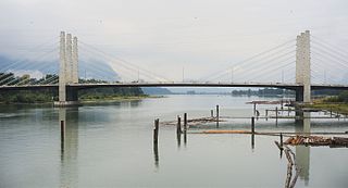
The Pitt River Bridge is a cable-stayed bridge that spans the Pitt River between Port Coquitlam and Pitt Meadows in British Columbia, Canada. The bridge is part of Highway 7, carrying Lougheed Highway across the river. The current bridge opened on October 4, 2009. The bridge includes a 380 m cable stay bridge structure, 126 m of multi-span approaches, a 50 m interchange structure and approximately 2 km of grade construction. Total project cost for the bridge was $200 million

<span class="mw-page-title-main">Slocan, British Columbia</span> Village in British Columbia, Canada

The Village of Slocan is in the West Kootenay region of southeastern British Columbia. The former steamboat landing and ferry terminal is at the mouth of Springer Creek, at the foot of Slocan Lake. The locality, on BC Highway 6 is about 69 kilometres (43 mi) by road north of Castlegar and 183 kilometres (114 mi) by road and ferry south of Revelstoke.

<span class="mw-page-title-main">Katrine Conroy</span> Canadian politician

Katrine Conroy is an MLA for Kootenay West and Minister of Forests in the Canadian province of British Columbia.

The British Columbia Ministry of Transportation and Infrastructure is the British Columbia government ministry responsible for transport infrastructure and law in the Canadian province of British Columbia. It is currently led by Rob Fleming.

<span class="mw-page-title-main">Big Bar Ferry</span>

Big Bar Ferry is a cable ferry across the Fraser River in British Columbia, Canada. It is located about 60 kilometres (37 mi) north of the town of Lillooet and 72 kilometres (45 mi) west of Clinton. 6 km upstream from the ferry is French Bar Canyon, while downstream is High Bar Canyon . The ferry connects the dirt ranch road up the west side of the Fraser from Lillooet to Big Bar and Kostering, which connect via road to Jesmond and Big Bar Lake, and beyond to BC Highway 97.

Robson is an unincorporated community in the West Kootenay region of southeastern British Columbia. The former steamboat landing and railway terminal is on the northeast side of the Columbia River. The residential area is off Broadwater Road, within the northwest part of Greater Castlegar.

<span class="mw-page-title-main">Needles Ferry</span> Cable ferry in British Columbia, Canada

The Needles Ferry is a cable ferry across Lower Arrow Lake in the West Kootenay region of southeastern British Columbia. Linking Needles and Fauquier, the ferry, part of BC Highway 6, is by road about 135 kilometres (84 mi) southeast of Vernon and 57 kilometres (35 mi) southwest of Nakusp.

<span class="mw-page-title-main">Monashee Pass</span> Mountain pass in British Columbia, Canada

Monashee Pass, 1,189 m (3,901 ft), is a mountain pass in the Monashee Mountains of the Southern Interior of British Columbia, Canada. Located southeast of Cherryville, the pass is used by British Columbia Highway 6 connecting Vernon to Nakusp on Arrow Lake, and beyond to the cities of the West Kootenay. It is the "prominence col" for Big White Mountain, which is the highest mountain to its southwest.

<span class="mw-page-title-main">Kootenay Lake ferry</span>

The Kootenay Lake ferry is a ferry across Kootenay Lake in southeastern British Columbia, which operates between Balfour, on the west side of the lake, and Kootenay Bay, on the east side. The MV Osprey 2000 and the MV Balfour are the two vessels used.

<span class="mw-page-title-main">Barnston Island Ferry</span>

The Barnston Island Ferry is a ferry across Parson's Channel between Barnston Island and Port Kells, Surrey, in Metro Vancouver.

Tarrys is an unincorporated community spanning both shores of the Kootenay River in the West Kootenay region of southeastern British Columbia. The location, on BC Highway 3A, is by road about 14 kilometres (9 mi) northeast of Castlegar, and 30 kilometres (19 mi) southwest of Nelson.

A series of ferries and bridges have crossed the Fraser River in the vicinity of Lillooet in the Squamish-Lillooet region of southwestern British Columbia. From the 1850s, these crossings have connected both north–south and local traffic.

<span class="mw-page-title-main">Upper Arrow Lake Ferry</span> Ferry in British Columbia, Canada

The Upper Arrow Lake Ferry is a ferry across Upper Arrow Lake in the West Kootenay region of southeastern British Columbia. Linking Shelter Bay and Galena Bay, the ferry, part of BC Highway 23, is by road about 52 kilometres (32 mi) south of Revelstoke and 47 kilometres (29 mi) north of Nakusp.

The Harrop Ferry is a cable ferry at Harrop Narrows on the west arm of Kootenay Lake in the West Kootenay region of southeastern British Columbia. The crossing, off BC Highway 3A, is by road about 27 kilometres (17 mi) northeast of Nelson and 7 kilometres (4 mi) west of Balfour.

References

  1. Province of British Columbia (2020). "Inland Ferries". gov.bc.ca. Retrieved 2020-09-11.
  2. Province of British Columbia (2020). "Adams Lake Cable Ferry". gov.bc.ca. Retrieved 2020-09-11.
  3. Province of British Columbia (2020). "Arrow Park Cable Ferry". gov.bc.ca. Retrieved 2020-09-11.
  4. Province of British Columbia (2020). "Barnston Island Ferry". gov.bc.ca. Retrieved 2020-09-11.
  5. Province of British Columbia (2020). "Big Bar Reaction Ferry". gov.bc.ca. Retrieved 2020-09-11.
  6. "Digby Island Ferry". Prince Rupert Airport. 2016-07-18. Retrieved 2022-05-20.
  7. Province of British Columbia (2020). "Francois Lake Ferry". gov.bc.ca. Retrieved 2020-09-11.
  8. Province of British Columbia (2020). "Glade Cable Ferry". gov.bc.ca. Retrieved 2020-09-11.
  9. Province of British Columbia (2020). "Harrop Cable Ferry". gov.bc.ca. Retrieved 2020-09-11.
  10. Province of British Columbia (2020). "Kootenay Lake Ferry". gov.bc.ca. Retrieved 2020-09-11.
  11. Province of British Columbia (2020). "Little Fort Reaction Ferry". gov.bc.ca. Retrieved 2020-09-11.
  12. Province of British Columbia (2020). "Lytton Reaction Ferry". gov.bc.ca. Retrieved 2020-09-11.
  13. Province of British Columbia (2020). "McClure Reaction Ferry". gov.bc.ca. Retrieved 2020-09-11.
  14. Province of British Columbia (2020). "Needles Cable Ferry". gov.bc.ca. Retrieved 2020-09-11.
  15. Province of British Columbia (2020). "Upper Arrow Lake Ferry". gov.bc.ca. Retrieved 2020-09-11.
  16. Province of British Columbia (2020). "Usk Reaction Ferry". gov.bc.ca. Retrieved 2020-09-11.
  17. 1 2 3 4 5 6 7 8 9 10 11 12 13 14 15 16 17 18 19 20 21 22 23 24 25 26 27 28 29 30 31 32 33 British Columbia Department of Public Works. REPORT OF THE MINISTER OF PUBLIC WORKS OF THE PROVINCE OF BRITISH COLUMBIA FOR THE FISCAL YEAR 1918-1919 (Report). Government of British Columbia.
  18. City of Castlegar. "History". castlegar.ca. City of Castlegar.
  19. British Columbia Ministry of Public Works (1935). Report of the Minister of Public Works for the Fiscal Year 1933/34 (Report). Victoria: Government of British Columbia. p. 96. doi:10.14288/1.0305802. J110.L5 S7; 1935_V02_05_O1_O104.
  20. Government of British Columbia (2001-08-02). "Inland Ferry Schedules". th.gov.bc.ca. Archived from the original on 2001-08-02. Retrieved 2022-07-14.
  21. "["K de K" steam ferry on the Fraser River] - City of Vancouver Archives". searcharchives.vancouver.ca. Retrieved 2022-07-14.
  22. "Brownsville Park and Sandbar :: The City of Surrey, British Columbia". web.archive.org. 2015-09-20. Archived from the original on 2015-09-20. Retrieved 2022-07-14.
  23. "Correspondence". The Sun. 24 February 1914 via proquest.com.
  24. "Your History: Born on the Pitt River Bridge (or Thereabouts)". Tri-City News. 16 October 2009 via proquest.com.
  25. "Public Works". The Province. 5 June 1903 via proquest.com.
  26. "Interesting Items". The Province. 29 September 1902 via proquest.com.
  27. "New Bridge Completed". The Daily Province. 5 March 1915 via proquest.com.
  28. British Columbia Archives. "OLD MSS LANDS RECORDS AT THE BC ARCHIVE" (PDF). royalbcmuseum.ca. Royal BC Museum.
  29. Priestley, Les (15 August 1982). "Ferries of British Columbia". Times Colonist. Times Colonist. Times Colonist. Retrieved 14 July 2022.