Pretoria is South Africa's administrative capital, serving as the seat of the executive branch of government, and as the host to all foreign embassies to South Africa.

The City of Tshwane Metropolitan Municipality, also known as the City of Tshwane, is the metropolitan municipality that forms the local government of northern Gauteng in South Africa. The metropolitan area is centred on the city of Pretoria with surrounding towns and localities included in the local government area.

Hammanskraal is an trans-provincial region anchored in northern Gauteng province, South Africa. The region consists of multiple residential, industrial, and commercial areas in a decentralized settlement pattern.

The R25 is a provincial route in South Africa that connects Johannesburg with Groblersdal via Kempton Park, Bapsfontein and Bronkhorstspruit.
Ga-Rankuwa is a large settlement located about 37 km north-west of Pretoria. Provincially it is in Gauteng province, but it used to fall in Bophuthatswana during the apartheid years, and under the North West province until the early 2000s.
Mabopane is a residential township in South Africa. It is situated in the Tshwane Metropolitan Municipality, to the north of Pretoria in Gauteng.
Radio and TV broadcasting in Pretoria is supplied via a network of VHF/FM and UHF transmitters and repeaters owned and operated by Sentech - South Africa's state-owned broadcast signal distributor - from four transmitter sites in and around the city. A number of community radio stations operate transmitters from non-Sentech sites.

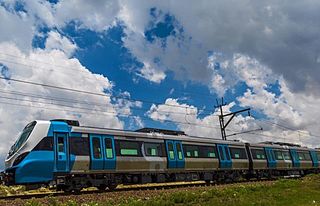
Metrorail Gauteng is a network of commuter rail services in Gauteng province in South Africa, serving the Johannesburg and Pretoria metro areas. It is operated by Metrorail, a division of the Passenger Rail Agency of South Africa (PRASA).
Pretoria Taal, or Pretoria Sotho, is the urban lingua franca of Pretoria and the Tshwane metropolitan area in South Africa. It is a combination of Sepedi-Tswana and influences from Tsotsitaal, Afrikaans and other Bantu languages of the region. It is spoken by most black residents of all ages and levels of education in Tshwane. Though it is most commonly used in informal situations, it is also used in schools and at political events in which people have different language backgrounds. Standard Setswana and Northern Sotho are not commonly used in schools except in SeTswana and Northern Sotho lessons. Pretoria Taal is mutually intelligible with SeTswana and Northern Sotho.
The R513 is a Regional Route in South Africa that connects Hartbeespoort with Bronkhorstspruit via Akasia, Pretoria North and Cullinan.
The R566 is a Regional Route in South Africa that connects Brits with Pretoria North via Ga-Rankuwa and Rosslyn.
The following is a timeline of the history of Pretoria, in the City of Tshwane Metropolitan Municipality, Gauteng province, South Africa.
The Tshwane riots occurred in the South African city of Pretoria and the surrounding City of Tshwane Metropolitan Municipality for several days from 20 June 2016, leading to the deaths of at least five people.
Equestria is a suburb of Pretoria, South Africa, situated approximately 18 kilometres east of the city centre.
The M10 road is a long metropolitan route in the City of Tshwane in Gauteng, South Africa. It connects Sunderland Ridge with Mamelodi via Lyttelton and Garsfontein.
The M30 road is a metropolitan route in the City of Tshwane in Gauteng, South Africa. It connects Brooklyn with Welbekend via Menlyn and Garsfontein. It is an alternative route to the M6 between Brooklyn and Welbekend.
The M1 road is a short metropolitan route in the City of Tshwane in Gauteng, South Africa. It connects Pretoria West and the Pretoria CBD with Pretoria North via Mayville.
The M21 road is a long metropolitan route in the City of Tshwane in Gauteng, South Africa. It connects Ga-Rankuwa with Hammanskraal via Mabopane and Soshanguve.
The M33 road is a short metropolitan route in the City of Tshwane in Gauteng, South Africa. It consists of only one road in Pretoria East, connecting Constantia Park with Lynnwood Ridge.


