List of castles in the Netherlands

Last updated

This is a list of castles in the Netherlands per province.

Contents

Overview of castles in the Netherlands

Drenthe

See also List of havezates in Drenthe

CastleLocationImage
Coevorden Castle Coevorden, Drenthe Kasteel van coevorden.jpg

Flevoland

CastleLocationImage
Almere Castle Almere, Flevoland Kasteel Almere 2a.jpg

Friesland

See List of stins in Friesland

Gelderland

CastleLocationImage
Ammersoyen Castle Ammerzoden, Gelderland
51°45′06″N5°13′45″E / 51.75167°N 5.22917°E / 51.75167; 5.22917
Ammersoyen 120307-3.JPG
Batenburg Castle Batenburg, Gelderland
51°49′25″N5°37′52″E / 51.82361°N 5.63111°E / 51.82361; 5.63111
Batenburg 01806.JPG
Bemmel Castle Bemmel, Gelderland
51°53′33″N5°53′44″E / 51.89250°N 5.89556°E / 51.89250; 5.89556
Bemmel.JPG
Bergh Castle 's-Heerenberg, Gelderland
51°52′27″N6°14′27″E / 51.87417°N 6.24083°E / 51.87417; 6.24083
Huis Bergh.JPG
Biljoen Castle Rheden, Gelderland
51°59′48″N5°59′33″E / 51.99667°N 5.99250°E / 51.99667; 5.99250
Biljoen DSCF0010.JPG
Blankenborg Castle Beuningen, Gelderland
51°51′52″N5°46′12″E / 51.86444°N 5.77000°E / 51.86444; 5.77000
Beuningen Rijksmonument 9538 Torentje restant kasteel de Blankenburgh.JPG
Brakel Castle Brakel, Gelderland
51°49′01″N5°05′56″E / 51.81694°N 5.09889°E / 51.81694; 5.09889
Ruine van Brakel.jpg
Cannenburgh Castle Vaassen, Gelderland
52°17′30″N5°58′00″E / 52.29167°N 5.96667°E / 52.29167; 5.96667
Vaassen, de Cannenburch RM15361 positie2 foto2 2013-08-01 14.55.jpg
Doddendael Castle Ewijk, Gelderland
51°52′27″N5°44′51″E / 51.87417°N 5.74750°E / 51.87417; 5.74750
Ewijk (Beuningen) Rijksmonument 520284 Huis van Slot Doddendaal.JPG
Doornenburg Castle Doornenburg, Gelderland
51°53′37″N5°59′56″E / 51.89361°N 5.99889°E / 51.89361; 5.99889
Kasteel doornenburg.jpg
Doorwerth Castle Doorwerth, Gelderland
51°58′00″N5°47′20″E / 51.96667°N 5.78889°E / 51.96667; 5.78889
Castle doorwerth colour.jpg
Goudenstein Castle Haaften, Gelderland
51°49′00″N5°13′00″E / 51.81667°N 5.21667°E / 51.81667; 5.21667
Goudenstein.jpg
Hackfort Castle Vorden, Gelderland
52°06′00″N6°16′37″E / 52.10000°N 6.27694°E / 52.10000; 6.27694
Hackfort.jpg
Hatert Castle Nijmegen, Gelderland
51°48′32″N5°49′09″E / 51.80889°N 5.81917°E / 51.80889; 5.81917
Hatert.jpg
Hernen Castle Hernen, Gelderland
51°50′4″N5°40′35″E / 51.83444°N 5.67639°E / 51.83444; 5.67639
Kasteel Hernen.jpg
Jachtslot Sint Hubertus Otterlo, Gelderland
52°07′18″N5°49′58″E / 52.12167°N 5.83278°E / 52.12167; 5.83278
Hubertusslot.jpg
De Kelder Castle
Hagen Castle
Doetinchem, Gelderland
51°59′22″N6°16′13″E / 51.98944°N 6.27028°E / 51.98944; 6.27028
Havezate Hagen voorkant.jpg
Keppel Castle Laag-Keppel, Gelderland
51°59′37″N6°13′38″E / 51.99361°N 6.22722°E / 51.99361; 6.22722
Kasteel keppel 2007.jpg
Kinkelenburg Castle Bemmel, Gelderland
51°53′23″N5°53′46″E / 51.88972°N 5.89611°E / 51.88972; 5.89611
Kinkelenburg.JPG
Merckenburg Castle Heukelum, Gelderland
51°52′40″N5°05′24″E / 51.87778°N 5.09000°E / 51.87778; 5.09000
Kasteel Heukelum.jpg
Loevestein Castle Poederoijen, Gelderland
51°48′59″N5°01′14″E / 51.81639°N 5.02056°E / 51.81639; 5.02056
Slotloevestein.jpg
Huis van Malsen
Castle van Well
Well, Gelderland
51°44′47″N5°12′24″E / 51.74639°N 5.20667°E / 51.74639; 5.20667
WellGld-Kasteel.jpg
Middachten Castle De Steeg, Gelderland
52°01′09″N6°04′11″E / 52.01917°N 6.06972°E / 52.01917; 6.06972
Kasteel Middachten.jpg
Het Oude Loo Apeldoorn, Gelderland
52°14′07″N5°56′32″E / 52.23528°N 5.94222°E / 52.23528; 5.94222
Oude Loo 2.jpg
Nederhemert Castle Nederhemert, Gelderland
51°45′15″N5°09′15″E / 51.75417°N 5.15417°E / 51.75417; 5.15417
Nederhemert (2).JPG
Nijenbeek Castle Voorst, Gelderland
52°11′12″N6°09′42″E / 52.18667°N 6.16167°E / 52.18667; 6.16167
Slot Nijenbeek southside.JPG
Ophemert Castle Ophemert, Gelderland
51°50′53″N5°23′26″E / 51.84806°N 5.39056°E / 51.84806; 5.39056
Kasteel ophemert.JPG
Poelwijk Castle Gendt, Gelderland
51°52′19″N5°57′55″E / 51.87194°N 5.96528°E / 51.87194; 5.96528
Poelwijk 2.jpg
Rosendael Castle Rozendaal, Gelderland
52°00′34″N5°57′52″E / 52.00944°N 5.96444°E / 52.00944; 5.96444
Kasteel Rosendael (Rozendaal-NL) (Foto-mo).jpg
Huis te Ruurlo Ruurlo, Gelderland
52°04′44″N6°26′42″E / 52.07889°N 6.44500°E / 52.07889; 6.44500
Huis ruurlo.JPG
Ryswyk Castle Groessen, Gelderland
51°55′37″N6°01′59″E / 51.92694°N 6.03306°E / 51.92694; 6.03306
Slangenburg Castle Doetinchem, Gelderland
51°57′38″N6°21′39″E / 51.96056°N 6.36083°E / 51.96056; 6.36083
Slangenburg 33.JPG
Het Valkhof Nijmegen, Gelderland
51°50′52″N5°52′15″E / 51.84778°N 5.87083°E / 51.84778; 5.87083
Dead Man Running @ de-Affaire Nijmegen.jpg
Huis te Vorden Vorden, Gelderland
52°06′05″N6°19′21″E / 52.10139°N 6.32250°E / 52.10139; 6.32250
Vorden 041.JPG
Waardenburg Castle Waardenburg, Gelderland
51°49′54″N5°15′59″E / 51.83167°N 5.26639°E / 51.83167; 5.26639
Kasteel Waardenburg Waardenburg Castle (4510403357).jpg
Wageningen Castle Wageningen, Gelderland
51°57′59″N5°40′01″E / 51.96639°N 5.66694°E / 51.96639; 5.66694
Wageningen old city ruins.JPG
Waliën Castle Winterswijk, Gelderland
51°59′30″N6°44′06″E / 51.99167°N 6.73500°E / 51.99167; 6.73500
Walien.jpg
Wisch Castle
Hof Terborg
Terborg, Gelderland
51°55′03″N6°21′23″E / 51.91750°N 6.35639°E / 51.91750; 6.35639
Kasteel wisch terborg.jpg
Wijenburg Castle Echteld, Gelderland
51°54′34″N5°30′01″E / 51.90944°N 5.50028°E / 51.90944; 5.50028
Wijenburg achterkant 2.jpg

Groningen

See List of borgs in Groningen (province)

Limburg

CastleConstruction dateLocationImage
Baarlo Castle Maasbree, Limburg
51°19′44″N6°05′58″E / 51.32889°N 6.09944°E / 51.32889; 6.09944
Baarlo.jpg
Bleijenbeek Castle Bleijenbeek, Limburg
51°38′06″N6°03′05″E / 51.63500°N 6.05139°E / 51.63500; 6.05139
Bleijenbeek-Afferden (2).JPG
Château Neercanne Maastricht, Limburg
50°49′07.9″N5°40′03″E / 50.818861°N 5.66750°E / 50.818861; 5.66750
Chateau Neercanne Neercanne Castle (Explore) (6317792842).jpg
Château St. Gerlach Houthem, Limburg
50°52′10.4″N5°47′57.7″E / 50.869556°N 5.799361°E / 50.869556; 5.799361
Overzicht voorgevel Proostenhuis met rechts de kerk - Houthem - 20423071 - RCE.jpg
Genhoes Castle Oud-Valkenburg, Limburg
50°51′20″N5°51′22″E / 50.85556°N 5.85611°E / 50.85556; 5.85611
Kasteel Genhoes 5a.jpg
Hillenraad Castle Late 14th century with

additions (e.g., towers)

in the 17th and 18th century

Swalmen, Limburg
51°13′18″N6°2′03″E / 51.22167°N 6.03417°E / 51.22167; 6.03417
Hillenraad Castle.jpg
Hoensbroek Castle Hoensbroek, Limburg
50°55′01″N5°55′05″E / 50.91694°N 5.91806°E / 50.91694; 5.91806
Heerlen-Kasteel Hoensbroek-1.JPG
Jansgeleen Castle Spaubeek, Limburg
50°56′00″N5°51′00″E / 50.93333°N 5.85000°E / 50.93333; 5.85000
StJansGeleen-004.jpg
Landsfort Heerlen Heerlen, Limburg
50°53′16″N5°58′49″E / 50.88778°N 5.98028°E / 50.88778; 5.98028
Heerlen Pancratiuskerk en Schelmentoren.jpg
Mheer Castle Mheer, Limburg
50°46′49″N5°47′27″E / 50.78028°N 5.79083°E / 50.78028; 5.79083
Mheer-001.JPG
Ouborg Castle Approximately 1300 Swalmen, Limburg
51°13′54″N6°1′32″E / 51.23167°N 6.02556°E / 51.23167; 6.02556
Naborch2010.jpg
Rivieren Castle Voerendaal, Limburg
50°53′50″N5°55′28″E / 50.89722°N 5.92444°E / 50.89722; 5.92444
KesjtieelReviere.jpg
Schaloen Castle Oud-Valkenburg, Limburg
50°51′25″N5°51′03″E / 50.85694°N 5.85083°E / 50.85694; 5.85083
Kasteel Schaloen.jpg
Ter Worm Castle Heerlen, Limburg
50°53′22″N5°56′59″E / 50.88944°N 5.94972°E / 50.88944; 5.94972
Terworm-022.jpg
Valkenburg Castle Valkenburg aan de Geul, Limburg
50°51′43″N5°49′52″E / 50.86194°N 5.83111°E / 50.86194; 5.83111
Kasteel Valkenburg gezien vanaf lourdesgrot.jpg
Well Castle Well, Limburg
51°33′9″N6°5′20″E / 51.55250°N 6.08889°E / 51.55250; 6.08889
Kasteel Well Photo.jpg
Wittem Castle Wittem, Limburg
50°48′50″N5°54′36″E / 50.81389°N 5.91000°E / 50.81389; 5.91000
WITTEM-002.JPG

North Brabant

CastleLocationImage
Aldendriel Castle Mill, North Brabant
51°41′14.54″N5°47′17.83″E / 51.6873722°N 5.7882861°E / 51.6873722; 5.7882861
Mill - Kasteelsestraat 2 - Kasteel Aldendriel (2).JPG
Great Castle Deurne, North Brabant
51°28′11″N5°48′10″E / 51.46972°N 5.80278°E / 51.46972; 5.80278
GrootKasteel.jpg
Bouvigne Castle Breda, North Brabant
51°33′45″N4°47′00″E / 51.56250°N 4.78333°E / 51.56250; 4.78333
Bredabouvigne.jpg
Breda Castle Breda, North Brabant
51°35′17″N4°46′19″E / 51.58806°N 4.77194°E / 51.58806; 4.77194
Breda kasteel.jpg
Croy Castle Aarle-Rixtel, North Brabant
51°30′00″N5°37′27″E / 51.50000°N 5.62417°E / 51.50000; 5.62417
CroyCastleTheNetherlands.jpg
Dussen Castle Werkendam, North Brabant
51°44′02″N4°58′10″E / 51.73389°N 4.96944°E / 51.73389; 4.96944
20070705Kasteel Dussen.jpg
Dommelrode Castle Sint-Oedenrode, North Brabant
51°33′36″N5°27′40″E / 51.56000°N 5.46111°E / 51.56000; 5.46111
Dommelrode-St. Oedenrode (10).JPG
Geldrop Castle Geldrop-Mierlo, North Brabant
51°25′29″N5°33′35″E / 51.42472°N 5.55972°E / 51.42472; 5.55972
Kasteel Geldrop, achterzijde.JPG
Heeswijk Castle Heeswijk, North Brabant
51°39′21″N5°26′26″E / 51.65583°N 5.44056°E / 51.65583; 5.44056
Kasteel Heeswijk 09.JPG
Heeze Castle
Eymerick Castle
Heeze, North Brabant
51°22′52″N5°35′15″E / 51.38111°N 5.58750°E / 51.38111; 5.58750
Heeze001.JPG
Henkenshage Sint-Oedenrode, North Brabant
51°33′32″N5°27′23″E / 51.55889°N 5.45639°E / 51.55889; 5.45639
Henkenshage-St. Oedenrode (2).JPG
Helmond Castle Helmond, North Brabant
51°28′37″N5°39′10″E / 51.47694°N 5.65278°E / 51.47694; 5.65278
Helmond achter 4.jpg
Maurick Castle Vught, North Brabant
51°39′31″N5°18′20″E / 51.65861°N 5.30556°E / 51.65861; 5.30556
CastleMaurickVught.JPG
Nemerlaer Castle Haaren, North Brabant
51°35′21″N5°13′54″E / 51.58917°N 5.23167°E / 51.58917; 5.23167
KasteelNemerlaer.jpg
Loon op Zand Castle Loon op Zand, North Brabant
51°37′28″N5°04′28″E / 51.62444°N 5.07444°E / 51.62444; 5.07444
515255 Kasteel Loon op Zand.jpg
Onsenoort Castle Nieuwkuijk, North Brabant
51°42′07″N5°11′25″E / 51.70194°N 5.19028°E / 51.70194; 5.19028
Onsenoort.JPG
Small Castle Deurne, North Brabant
51°28′24″N5°48′15″E / 51.47333°N 5.80417°E / 51.47333; 5.80417
Klein Kasteel Deurne NL voorzijde B.jpg
Stapelen Castle Boxtel, North Brabant
51°34′59″N5°19′27″E / 51.58306°N 5.32417°E / 51.58306; 5.32417
Kasteel Stapelen.jpg
Strijen Castle Oosterhout, North Brabant
51°39′19″N4°51′32″E / 51.65528°N 4.85889°E / 51.65528; 4.85889
Ruineoosterhout.jpg
Slotje Limburg Oosterhout, North Brabant
51°38′25.19″N4°51′30.53″E / 51.6403306°N 4.8584806°E / 51.6403306; 4.8584806
F1020032.JPG
Tongelaar Castle Beers, North Brabant
51°42′47″N5°46′48″E / 51.71306°N 5.78000°E / 51.71306; 5.78000
Gassel-Mill, chateau Tongelaar (manoir).JPG
Zwijnsbergen Castle Helvoirt, North Brabant
51°38′32″N5°13′19″E / 51.64222°N 5.22194°E / 51.64222; 5.22194
Zwijnsbergen ponys 2.JPG

North Holland

CastleLocationImage
Slot Assumburg Heemskerk, North Holland
52°30′18″N4°41′07″E / 52.50500°N 4.68528°E / 52.50500; 4.68528
Heemskerk kasteel.jpg
Brederode Castle Santpoort, North Holland
52°25′31″N4°37′21″E / 52.42528°N 4.62250°E / 52.42528; 4.62250
Santpoort brederode.jpg
Huis ter Kleef Haarlem, North Holland
52°23′44″N4°38′13″E / 52.39556°N 4.63694°E / 52.39556; 4.63694
Ruines Huis ter Kleef.jpg
Slot Heemstede Heemstede, North Holland
52°20′23″N4°37′53″E / 52.33972°N 4.63139°E / 52.33972; 4.63139
Oudeslot.jpg
Ilpenstein Castle Ilpendam, North Holland
52°27′52″N4°57′27″E / 52.46444°N 4.95750°E / 52.46444; 4.95750
Ilpenstein (1622-1872).jpg
Muider Castle (Muiderslot) Muiden, North Holland
52°20′03″N5°04′17″E / 52.33417°N 5.07139°E / 52.33417; 5.07139
Muiderslot by Edi Weissmann.jpg
Radboud Castle Medemblik, North Holland
52°46′21″N5°06′47″E / 52.77250°N 5.11306°E / 52.77250; 5.11306
Kasteel Radboud.JPG

Overijssel

CastleLocationImage
Huize Almelo Almelo, Overijssel
52°21′29″N6°40′18″E / 52.35806°N 6.67167°E / 52.35806; 6.67167
Huize Almelo.jpg
Rechteren Castle Dalfsen, Overijssel
52°29′52″N6°17′20″E / 52.49778°N 6.28889°E / 52.49778; 6.28889
11665 Rechteren kasteel 2010.JPG
Twickel Castle Delden, Overijssel
52°15′59″N6°42′54″E / 52.26639°N 6.71500°E / 52.26639; 6.71500
2006-07-15 11.20 Delden, kasteel Twickel.JPG
Waardenborg Castle Holten, Overijssel
52°16′53″N6°25′07″E / 52.28139°N 6.41861°E / 52.28139; 6.41861
517-25-Wielen-2005.jpg

South Holland

CastleLocationImage
Huys Dever Lisse, South Holland
52°14′56″N4°32′51″E / 52.24889°N 4.54750°E / 52.24889; 4.54750
Lissededever.jpg
Duivenvoorde Castle Voorschoten, South Holland
52°06′41″N4°25′03″E / 52.11139°N 4.41750°E / 52.11139; 4.41750
Kasteel Duivenvoorde 015.jpg
Burcht van Leiden Leiden, South Holland
52°09′32″N4°29′33″E / 52.15889°N 4.49250°E / 52.15889; 4.49250
De burcht leiden 2003.jpg
Rhoon Castle Rhoon, South Holland
51°51′37″N4°25′05″E / 51.86028°N 4.41806°E / 51.86028; 4.41806
Rhoon 006.jpg
Slot Teylingen Voorhout, South Holland
52°13′52″N4°31′09″E / 52.23111°N 4.51917°E / 52.23111; 4.51917
Teylingen.jpg

Utrecht

See also List of manors in Utrecht

CastleLocationImage
Amerongen Castle Amerongen, Utrecht
51°59′44″N5°27′31″E / 51.99556°N 5.45861°E / 51.99556; 5.45861
2006-04-25 10.48.1 Amerongen, kasteel.JPG
Beesde Castle
Huis Cammingha
Bunnik, Utrecht
52°04′19″N5°11′46″E / 52.07194°N 5.19611°E / 52.07194; 5.19611
De Beesde Bunnik.jpg
Beverweerd Castle Werkhoven, Utrecht
52°01′55″N5°15′00″E / 52.03194°N 5.25000°E / 52.03194; 5.25000
Beverweerd.jpg
Bolenstein Maarssen, Utrecht
52°08′24″N5°02′11″E / 52.14000°N 5.03639°E / 52.14000; 5.03639
Boelenstein maarssen.jpg
Huis Doorn Doorn, Utrecht
52°01′53″N5°20′19″E / 52.03139°N 5.33861°E / 52.03139; 5.33861
2007-04-09 14.41 Doorn, huize Doorn foto4.JPG
Drakensteyn Castle Lage Vuursche, Utrecht
52°10′47″N5°13′38″E / 52.17972°N 5.22722°E / 52.17972; 5.22722
Madurodam - Kasteel Drakestein.jpg
Duurstede Castle Wijk bij Duurstede, Utrecht
51°58′10″N5°20′36″E / 51.96944°N 5.34333°E / 51.96944; 5.34333
Wijk bij duurstede kasteel1.jpg
De Haar Castle Vleuten, Utrecht
52°07′17″N4°59′11″E / 52.12139°N 4.98639°E / 52.12139; 4.98639
Kasteel de Haer.jpg
Gunterstein Castle Breukelen, Utrecht
52°10′20″N5°0′21″E / 52.17222°N 5.00583°E / 52.17222; 5.00583
Gunterstein.jpg
Hamtoren (Den Ham Castle) Vleuten, Utrecht
52°06′20″N4°59′44″E / 52.10556°N 4.99556°E / 52.10556; 4.99556
Hamtoren Vleuten.jpg
Hardenbroek Castle Driebergen, Utrecht
52°00′39″N5°17′01″E / 52.01083°N 5.28361°E / 52.01083; 5.28361
Hardenbroek-1998.jpg
Harmelen Castle Harmelen, Utrecht
52°05′46″N4°58′03″E / 52.09611°N 4.96750°E / 52.09611; 4.96750
Hinderstein Castle Langbroek, Utrecht
52°00′52″N5°18′40″E / 52.01444°N 5.31111°E / 52.01444; 5.31111
Hinderstein-1999.jpg
Loenersloot Castle Loenersloot, Utrecht
52°13′46″N4°59′49″E / 52.22944°N 4.99694°E / 52.22944; 4.99694
Kasteel loenersloot.jpg
Lunenburg Castle Langbroek, Utrecht
52°00′43″N5°19′12″E / 52.01194°N 5.32000°E / 52.01194; 5.32000
Moersbergen Castle Doorn, Utrecht
52°01′37″N5°19′11″E / 52.02694°N 5.31972°E / 52.02694; 5.31972
Moersbergen.jpg
Nijenrode Castle Breukelen, Utecht
52°09′49″N5°00′33″E / 52.16361°N 5.00917°E / 52.16361; 5.00917
Nijnerode.jpg
Sterkenburg Castle Sterkenburg, Utrecht
52°01′24″N5°17′01″E / 52.02333°N 5.28361°E / 52.02333; 5.28361
Sterkenburg aanzicht.jpg
Vredenburg Castle Utrecht (city), Utrecht
52°05′33″N5°06′50″E / 52.09250°N 5.11389°E / 52.09250; 5.11389
Fundamenten kasteel Vredenburg.jpg
Woerden Castle Woerden, Utrecht
52°05′06″N4°53′17″E / 52.08500°N 4.88806°E / 52.08500; 4.88806
Kasteel Woerden 02.JPG
Zuylen Castle Oud-Zuilen, Utrecht
52°04′37″N5°04′23″E / 52.07694°N 5.07306°E / 52.07694; 5.07306
Slot Zuylen.jpg

Zeeland

CastleLocationImage
Baarland Castle Baarland, Zeeland
51°24′31″N3°53′13″E / 51.408633°N 3.886885°E / 51.408633; 3.886885
Baarland1.jpg
Haamstede Castle Haamstede, Zeeland
51°41′51″N3°44′30″E / 51.69750°N 3.74167°E / 51.69750; 3.74167
Slot Haamstede met poortgebouw.JPG
Hellenburg Baarland, Zeeland
51°24′32″N3°52′46″E / 51.40889°N 3.87944°E / 51.40889; 3.87944
HellenburgRuine.jpg
Moermond Castle Renesse, Zeeland
51°44′00″N3°47′11″E / 51.73333°N 3.78639°E / 51.73333; 3.78639
Schloss Moermond.jpg
Sabbinge Castle Oud-Sabbinge, Zeeland
51°31′56″N3°47′58″E / 51.53222°N 3.79944°E / 51.53222; 3.79944
Oud-Sabbinge.jpg
Westhove Castle Domburg, Zeeland
51°34′10″N3°31′19″E / 51.56944°N 3.52194°E / 51.56944; 3.52194
Kasteel Westhove oostkapelle.jpg

See also

Related Research Articles

The Union of Utrecht was a treaty signed on 23 January 1579 in Utrecht, Netherlands, unifying the northern provinces of the Netherlands, until then under the control of Habsburg Spain.

<span class="mw-page-title-main">Loevestein Castle</span> Dutch medieval castle in Zaltbommel

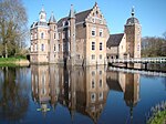
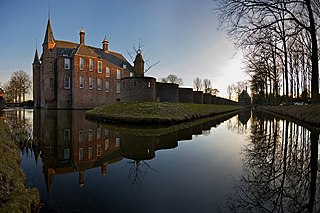
Loevestein Castle is a medieval castle in the municipality of Zaltbommel, Gelderland, the Netherlands.

<span class="mw-page-title-main">Vollenhove</span> City in Overijssel, Netherlands

Vollenhove is a city in the Dutch province of Overijssel. It is located in the municipality of Steenwijkerland, southwest of Steenwijk. Until the Noordoostpolder was drained, it was located on the coast of the Zuiderzee.

<span class="mw-page-title-main">Muiden Castle</span> Castle at the mouth of the Vecht river in the Netherlands

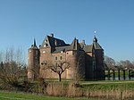
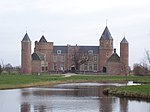
Muiden Castle is a castle in the Netherlands, located at the mouth of the Vecht river, some 15 kilometers southeast of Amsterdam, in Muiden, where it flows into what used to be the Zuiderzee. It is one of the better known castles in the Netherlands and featured in many television shows set in the Middle Ages.

<span class="mw-page-title-main">Fraeylemaborg</span> Historic house museum in Slochteren, Netherlands

The Fraeylemaborg is a borg in the village of Slochteren in the Netherlands. At present the Fraeylemaborg is a historic house museum. The museum had 31,509 visitors in 2013.

<span class="mw-page-title-main">Heeze Castle</span> Castle in the Netherlands

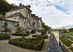
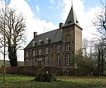
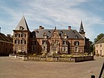
Heeze Castle is situated in the Netherlands, south of Eindhoven. It used to be the centre of the seigneury of Heeze, Leende and Zesgehuchten, part of the Duchy of Brabant. In the Middle Ages, it was owned by the de Horne family. In the seventeenth Century Pieter Post designed a new castle, of which the first part was built in 1665. After Pieter Post died, the work was completed by his son Maurits Post.

<span class="mw-page-title-main">Valkenburg Castle</span> Ruined castle in Valkenburg aan de Geul, Netherlands

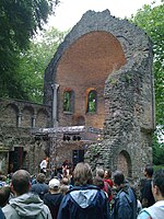
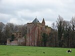
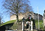
Valkenburg Castle is a ruined castle in Valkenburg aan de Geul, Netherlands. It is unique in the Netherlands in that it is the only castle in the country built on a hill. The castle is listed in the top hundred of Dutch cultural monuments.

The Netherlands has several levels of administrative subdivisions. The first level of subdivision consists of 12 provinces. The second level of subdivision consists of 342 municipalities.

<span class="mw-page-title-main">Menkemaborg</span> Historic house museum in Uithuizen, Netherlands

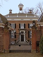
The Menkemaborg is a borg (castle) in the village of Uithuizen in Groningen in the Netherlands. Since 1927, the borg is a historic house museum.

<span class="mw-page-title-main">Heemstede Castle</span> Castle in the Netherlands, now demolished

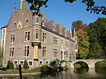
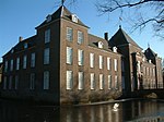
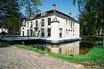
Heemstede Castle is the site of the old castle of Heemstede. The property is situated at the site of the former castle 'Heerlijkheid Heemstede', or 'Huis te Heemstede', at a strategic position on mouth of the Spaarne river on the Haarlem lake.

<span class="mw-page-title-main">Nietap</span> Village in Drenthe, Netherlands

Nietap is a village in the Netherlands and is part of the Noordenveld municipality in Drenthe.

<span class="mw-page-title-main">Jansgeleen Castle</span>

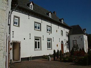
Jansgeleen Castle, now erroneously called Sint-Jansgeleen or Sint Jansgeleen, was a medieval castle in the little village of Spaubeek, in the Dutch province of Limburg. Spaubeek is located in the municipality of Beek, about 3 km south of the town of Geleen. Spaubeek was a separate municipality until 1982, when it was merged with Beek.

<span class="mw-page-title-main">Stins</span>

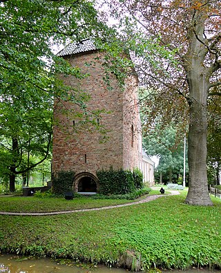
A stins is a former stronghold or villa in the province of Friesland, the Netherlands. Many stinsen carry the name "state".

<span class="mw-page-title-main">Croy Castle</span> Castle in the Netherlands

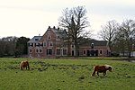
The castle Croy is a castle in the Dutch province North Brabant, near the village Aarle-Rixtel which is part of the municipality of Laarbeek. From 1642 until 1968 Croy belonged to the municipality Stiphout.

<span class="mw-page-title-main">Zuylen Castle</span>

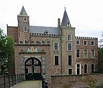
Zuylen Castle is a Dutch castle at the village of Oud-Zuilen just north of the city of Utrecht. It is located along the river Vecht at the southern end of the Vechtstreek.

<span class="mw-page-title-main">Huis Bergh</span> Castle in s-Heerenberg city, the Netherlands

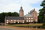
Huis Bergh is a castle in 's-Heerenberg city and is one of the largest castles in the Netherlands. It gives its name to the Land van den Bergh and was previously owned by the counts van Bergh.

<span class="mw-page-title-main">Qbuzz</span> Dutch public transport bus company

Qbuzz is a public transport company in the Netherlands that operates services in South Holland, Utrecht, Drenthe and Groningen. Founded in 2008, it was a subsidiary of Nederlandse Spoorwegen from 2013 until 2017. It is currently owned by Ferrovie dello Stato Italiane.

<span class="mw-page-title-main">Borg (castle)</span>

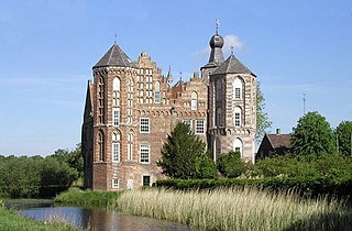
A borg is a former stronghold or villa in the province of Groningen, Netherlands. Borgs used to belong to noblemen or prominent citizens. A comparable building in the neighboring province of Friesland is called a stins.

References