
The Kanangra-Boyd National Park is a protected national park that is located in the Central Tablelands region, west of the Southern Highlands and Macarthur regions, in New South Wales, in eastern Australia. The 68,660-hectare (169,700-acre) national park is situated approximately 180 kilometres (110 mi) south-west of Sydney and is contiguous with the Blue Mountains National Park and the Nattai National Park. The park was established in 1969.

Oberon is a town located within the Oberon Council local government area, in the central tablelands region of New South Wales, Australia. The main industries are farming, forestry and wood products. The town usually receives snowfall during the winter months, owing to its high elevation. At the 2016 census, Oberon had a population of 3,256 people.

The Six Foot Track was originally a bridle trail from Katoomba to the Jenolan Caves, and is now a walking trail of 44.3 kilometers.

The Wombeyan Caves are caves that have formed in marble, in the Wombeyan Karst Conservation Reserve, New South Wales, Australia. Wombeyan Caves is a tourist attraction and local holiday area, as well as a reserve for endangered species, such as several species of wallaby, bird, possum, and wombat.
Megalong Valley is part of the Blue Mountains of New South Wales, Australia. It is located west of Katoomba. On its eastern side, the valley is separated from the Jamison Valley by Narrow Neck Plateau. The Shipley Plateau overlooks part of the valley.
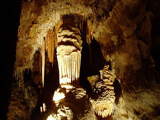
The Jenolan Caves are limestone caves located within the Jenolan Karst Conservation Reserve in the Central Tablelands region, west of the Blue Mountains, in Jenolan, Oberon Council, New South Wales, in eastern Australia. The caves and 3,083-hectare (7,620-acre) reserve are situated approximately 175 kilometres (109 mi) west of Sydney, 20 kilometres (12 mi) east of Oberon and 30 kilometres (19 mi) west of Katoomba.

A show cave — also called tourist cave, public cave, and in the United States, commercial cave — is a cave which has been made accessible to the public for guided visits.

Oberon Council is a local government area in the Central West region of New South Wales, Australia.

Mount Trickett, a mountain on the Great Dividing Range, is located approximately 6 kilometres (3.7 mi) west of Jenolan Caves, in the Central Tablelands region of New South Wales, Australia.
Styx River, a perennial stream of the Macleay River catchment, is located in the Northern Tablelands district of New South Wales, Australia.

The Bicentennial National Trail (BNT), originally known as the National Horse Trail, is one of the longest multi-use, non-motorised, self-reliant trails in the world, stretching 5,330 kilometres from Cooktown, Queensland, through New South Wales and the Australian Capital Territory to Healesville, 60 km north-east of Melbourne. This trail runs the length of the rugged Great Dividing Range through national parks, private property and alongside wilderness areas. The BNT follows old coach roads, stock routes, brumby tracks, rivers and fire trails. It was originally intended for horses, but is these days promoted also for cycling and walking, though it is not yet entirely suited to these two activities.
Mount Bindo, a mountain on the Great Dividing Range, is located in the Central Tablelands region of New South Wales, Australia.

The Borenore Caves, contained within the Borenore Karst Conservation Reserve, are a series of limestone caves that are located in the Central West region of New South Wales, Australia. The caves are renowned for their karst qualities, namely the numerous fossils from a long-lived reef complex from the Silurian period. Fossils include corals, crinoids, brachiopods, gastropods, pentamerids, colonial tryplasmids and trilobites. Borenore's karst is surrounded by igneous rock that flowed from volcanic eruptions at nearby Mount Canobolas.

The Jenolan River, a perennial river that is part of the Hawkesbury-Nepean catchment, is located in the Central Tablelands region of New South Wales, Australia.
Sydney University Speleological Society (SUSS) is a caving group based in Sydney, Australia, which aims to unite University of Sydney graduates, undergraduates, staff and all other people who are interested in the exploration and mapping of cave systems. The society fosters speleology as a science and sport and co-operates with other bodies in the furtherance of these aims. SUSS was founded in 1948 and is the oldest caving group on mainland Australia. It has been heavily involved in the exploration and mapping of various Australian cave systems since its formation. The society pioneered the sport of cave diving in Australia and was a founding member of the Australian Speleological Federation.
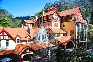
The Jenolan Caves House is a large, heritage-listed hotel, built in stages between 1879 and 1926. It is located in the remote Jenolan Caves Karst Conservation Reserve, Blue Mountains National Park, on the western edge of the Blue Mountains UNESCO World Heritage Area, in New South Wales, Australia.

Jenolan Caves Road is a rural road in New South Wales, Australia, linking the Great Western Highway at Hartley to Edith Road at Jenolan.