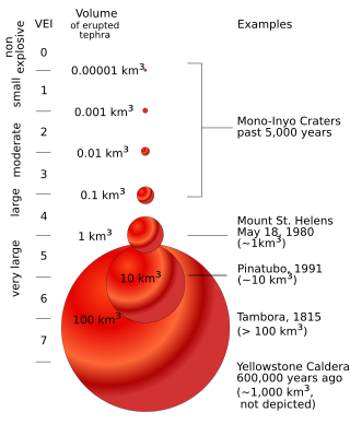
This is a list of volcanoes that have had large explosive eruptions during the Holocene (since about 11,650 years Before Present), with a VEI of 5 or higher, or plume height of at least 30 km. To date, there have been no eruptions with a confirmed VEI of 8 in the Holocene, and only a few VEI-7 eruptions are thought to have occurred during this time, with the most recent being the 1815 eruption of Mount Tambora. This is not a complete list.
VEI [1] | Volcano | Volcanic arc/belt, subregion, or hotspot | Bulk or DRE material volume (km3) [2] | Plume height (km) [2] | Date [1] | Tephra or eruption name | Notes |
---|---|---|---|---|---|---|---|
5 | Hunga Tonga-Hunga Haʻapai | Tonga-Kermadec Islands volcanic arc | 9.5 | 58 | 2022-01-15 | 2022 Hunga Tonga–Hunga Haʻapai eruption and tsunami | Largest atmospheric explosion recorded by modern instrumentation, heard as far away as Alaska, 10,000 km distant. |
5 | Puyehue-Cordón Caulle | Andean Volcanic Belt | 1 | 14 | 2011-06-04 | 2011–2012 Puyehue-Cordón Caulle eruption | Major flight disruptions in the Southern Hemisphere. |
4 | Chaitén | Andean Volcanic Belt | 30 | 2008-05-02 | |||
4 | Mount Tavurvur | Bismarck Volcanic Arc | 30 | 1994-09-19 | |||
5 | Mount Hudson | Andean Volcanic Belt | 4.3 | 18 | 1991-08-08 | ||
6 | Mount Pinatubo [3] | Luzon Volcanic Arc | 13 | 40 | 1991-06-15 | 1991 eruption of Mount Pinatubo | |
3 | Nevado del Ruiz | Andean Volcanic Belt | 31 | 1985-11-13 | Armero tragedy | ||
5 | El Chichón | Chiapanecan Volcanic Arc | 2 | 32 | 1982-04-04 | tephra unit A | |
5 | Mount St. Helens [3] | Cascade Volcanic Arc | 1.3 | 24 | 1980-05-18 | 1980 eruption of Mount St. Helens | landslide volume 0.7 mi3 (2.9 km3) |
5 | Mount Agung | Sunda Arc, Bali | 1 | 28 | 1963-03-17 | ||
5 | Bezymianny | Kamchatka | 1.9 | 45 | 1955 | ||
5 | Kharimkotan | Kuril Islands | 1 | 1933 | |||
5 | Quizapú | Andean Volcanic Belt | 9.5 | 30 | 1932 | ||
5 | Submarine Volcano NNE of Iriomote Island | Japan | 1 | 1924-10-31 | Underwater volcano. | ||
6 | Novarupta [3] | SW Alaska, Aleutian Arc | 31.2 | 26 | 1912-06-06 | ||
5 | Ksudach | Kamchatka | 1.75 | 22 | 1907-03-28 | ||
6 | Santa María [3] | Central America Volcanic Arc, Guatemala | 20 | 34 | 1902-10-24 | ||
5 | Mount Tarawera | Taupō Volcanic Zone | 2 | 34 | 1886-06-15 | 1886 eruption of Mount Tarawera | |
6 | Krakatoa [3] | Sunda Arc | 26 | 80 | 1883-08-26 | 1883 eruption of Krakatoa | The eruption of Krakatoa caused the loudest sound in recorded history |
5 | Askja | Iceland | 1.83 | 26 | 1875-03-28 | ||
5 | Shiveluch | Kamchatka | 2 | 1854-02-18 | |||
5 | Mount Agung | Sunda Arc, Bali | 1 | 1843 | |||
5 | Cosigüina | Central America Volcanic Arc, Nicaragua | 4.25 | 28 | 1835-01-20 | ||
5 | Mount Galunggung | Sunda Arc, Java | 2 | 1822-10-08 | killed over 4,000 people | ||
7 | Mount Tambora [3] | Sunda Arc, Sumbawa | 160-213 | 43 | 1815-04-10 | 1815 eruption of Mount Tambora | Caused the year without a summer, which caused crops to fail and killed over 100,000-200,000 people |
6 | Source unknown | Source unknown | 1808/1809 | Undocumented 1808 eruption [4] | |||
5 | Mount St. Helens | Cascade Volcanic Arc | 1.5 | 16 | 1800 | T (Goat Rocks) | |
5 | Katla | Iceland | 1 | 1755-10-17 | |||
5 | Mount Tarumae | Hokkaidō | 4 | 1739-08-18 | Ta-a | ||
5 | Katla | Iceland | 1 | 1721-05-11 | |||
5 | Mount Fuji | Honshū | 1.7 | 1707-12-16 / 1708-2-24 | Hōei eruption of Mount Fuji | ||
5 | Tangkoko | Sangihe Volcanic Arc | 1 | 1680 | |||
5 | Mount Gamkonora | Halmahera Volcanic Arc | 1 | 1673-05-20 | |||
5 | Mount Tarumae | Hokkaidō | 2.8 | 1667-09-24 | Ta-b | ||
5 | Mount Usu | Hokkaidō | 2.78 | 1663-08-16 | |||
6 | Long Island, PNG | Bismarck Volcanic Arc | > 30 | 1660 CE | Tibito tephra | ||
5 | Shiveluch | Kamchatka | ≥ 2 | 1652 CE ±11 | SH1 | ||
5 | Mount Melibengoy, [5] Philippines | Mindanao | 1 | 1640-12-26 | |||
5 | Komagatake | Hokkaidō | 2.9 | 1640-07-31 | Ko-d | landslide volume 1.72 – 2 km3 | |
5 | Mount Vesuvius | Campanian volcanic arc | 1.1 | 28 | 1631-12-16 | ||
5 | Furnas | São Miguel Island, Azores | 2.1 | 13 | 1630-09-03 | ||
5 | Katla | Iceland | 1 | 1625-09-02 | |||
6 | Huaynaputina | Andes, Central Volcanic Zone | 30 | 46 | 1600-02-19 | ||
5 | Raung | Sunda Arc, Java | 1 | 1593 CE | |||
5 | Kelud | Sunda Arc, Java | 1 | 1586 CE | |||
6 | Billy Mitchell | Bougainville & Solomon Is. | 13.5 | 1580 CE | BM2 | ||
5 | Água de Pau | São Miguel Island, Azores | 1.3 | 19 | 1563-06-28 / 1563-07-26 | ||
5 | Mount St. Helens | Cascade Volcanic Arc | 1.5 | 21 | 1482 CE | We (Kalama) | |
5 | Mount St. Helens | Cascade Volcanic Arc | 7.7 | 24 | 1480 CE | Wn (Kalama) | |
6 | Bárðarbunga | Iceland | 10 | 1477 CE | Veidivatnahraun | ||
5 | Sakurajima | Kyūshū | 1 | 1471-1476 CE | |||
7 | 1452/1453 mystery eruption | Unknown | 108 | 1452 - 1453 | |||
5 | Mount Pinatubo | Luzon Volcanic Arc | 1 | 1450 CE ±50 | Buag eruptive period | ||
5 | Öræfajökull | Iceland | 2.3 | 30 [6] | 1362-06-05 | Then called Knappafellsjökull. Completely destroyed Litlahérað . Volcano renamed after eruption. | |
5 | El Chichón | Chiapanecan Volcanic Arc | 2.8 | 31 | 1360 CE ±100 | tephra unit B | |
6 | Quilotoa | Andes, Northern Volcanic Zone | 21 | 35 | 1280 CE | ||
5 | Katla | Iceland | 1 | 1262 CE | |||
7 | Mount Samalas | Lombok Island | 130-200 | 43 | 1257 CE | 1257 Samalas eruption; | May have triggered the Little Ice Age [7] |
5 | Mount Asama | Honshū | 1.3 | 1108-08-29 / 1108-10-11 | Asama-B, Tennin eruption | ||
5 | Hekla | Iceland | 1.2 | 1104-10-15 | H1 tephra | ||
5 | Ubinas | Andes, Central Volcanic Zone | 2.8 | 1082 ±82 | |||
5 | Lake Mashū | Hokkaidō | 4.6 | 1080 ±100 | Ma-b | ||
5 | Shiveluch | Kamchatka | ≥ 2 | 1034 CE ±11 | SH2 | ||
5 | Billy Mitchell | Bougainville & Solomon Is. | 7 | 1030 CE | BM1 | ||
7 | Baekdu Mountain [3] | Balhae (China – North Korea border) | 120 | 36 | ~946 CE | Baegdusan-Tomakomai Tephra | Millennium eruption, Caldera stage IV |
5 | Katla | Iceland | 4.5 | 15 | 934-940 CE | Eldgjá eruption | over 18 km3 of basalt erupted from a fissure vents |
6 | Ceboruco | Trans-Mexican Volcanic Belt | 10.95 | 31 | 930 CE ±200 | Jala Pumice | |
5 | Towada [8] | Honshū | 6.54 | 30 | 915-08-17 | eruption episode A | |
5 | Puyehue | Andean Volcanic Belt | 4.32 | 860 CE ±75 | MH tephra | ||
6 | Mount Churchill | eastern Alaska | 50 | 45 | 847 CE ±1 | WRAe | Formed the Pumice Terrace |
5 | El Chichón | Chiapanecan Volcanic Arc | > 1 | 780 CE ±100 | tephra unit D | ||
6 | Pago | Bismarck Volcanic Arc | 20 | 710 CE ±75 | Witori-Galilo tephra | ||
5 | Pago | Bismarck Volcanic Arc | 6 | 690 CE ±90 | Witori-Kimbe 4 tephra | ||
6 | Rabaul | Bismarck Volcanic Arc | 24 | 683 CE | Rabaul Pyroclastics | ||
6 | Dakataua | Bismarck Volcanic Arc | 10 | 653 CE ±18 | Dk | ||
5 | Shiveluch | Kamchatka | ≥ 2 | 650 CE ±40 | SH3 | ||
5 | Opala | Kamchatka | 3.7 | 20 | 610 CE ±50 | Baranii Amphitheatre crater | |
5 | Shiveluch | Kamchatka | ≥ 2 | 600 CE | |||
5 | Mount Haruna | Honshū | 1.6 | 550 CE ±10 | Futatsudake-Ikaho eruption | ||
6-7 | Unknown source | Unknown | 535 CE | David Keys, Ken Wohletz, and others have postulated that a violent volcanic eruption, possibly of Krakatoa, in 535 was responsible for the global climate changes of 535–536. [9] Keys explores what he believes to be the radical and far-ranging global effects of such a putative 6th-century eruption in his book Catastrophe: An Investigation into the Origins of the Modern World. This eruption was believed to have been even more violent than Krakatoa's 1883 eruption, and also the one that created Krakatoa's original caldera, which resulted in the creation of Verlaten Island and Lang Island. [10] However, there are other explanations for the climate change, including an eruption of Ilopango in El Salvador, in Central America. | |||
5 | Mount Vesuvius | Campanian volcanic arc | 1.2 | 25 | 472-11-05 | Pollena | |
6-7 | Lake Ilopango | Central America Volcanic Arc, El Salvador | 84-104 | 31 | 450 CE ±20 | ||
5 | Akutan | Aleutian Arc | 1 | 340 | Akutan tephra | ||
5 | Pago | Bismarck Volcanic Arc | 6 | 310 CE ±100 | Witori-Kimbe 3 tephra | ||
6 | Ksudach | Kamchatka | 18.5 | 30 | 240 CE ±100 | KS1 | |
7 | Taupō Volcano [3] | Taupō Volcanic Zone | 110 | 51 | 233 ±13 CE | Hatepe eruption | |
5 | Masaya [3] | Central America Volcanic Arc, Nicaragua | 6.6 | 26 | 150 | Masaya Tuff | |
5 | Furnas | São Miguel Island, Azores | 1.54 | 17 | 80 ±100 | Tephra layer C | |
5 | Mount Vesuvius | Campanian volcanic arc | 3.25 | 32 | 79-10-24? | Eruption of Mount Vesuvius in 79 | |
6 | Mount Churchill | eastern Alaska | 10 | 60 CE ±200 | WRAn | ||
6 | Ambrym | Vanuatu | 70 | 50 CE ±100 | Ambrym Pyroclastic Series | ||
6 | Apoyeque | Central America Volcanic Arc, Nicaragua | 18 | 40 | 50 BCE ±100 | Apoyeque, Chiltepe Tephra | |
6 | Okmok Caldera | Umnak, Aleutian Arc | 50 | 100 BCE ±50 | Okmok II | ||
5 | Mount Etna | Campanian volcanic arc | 1 | 26 | 122 BCE | S flank, summit (Cratere del Piano caldera) | |
5 | Masaya [3] | Central America Volcanic Arc, Nicaragua | 3.4 | 29 | 170 BCE ±100 | Masaya Tuff | |
5 | Popocatépetl | Trans-Mexican Volcanic Belt | 3.2 | 30 | 200 BCE ±300 | I.A1 Yellow Pumice | |
6 | Raoul Island | Kermadec Islands | 28.8 | 250 BCE ±75 | Fleetwood | ||
5 | Mount Meager massif | Garibaldi Volcanic Belt | ⩾ 1 | 410 BCE ±200 | Bridge River eruption | ||
5 | Mount St. Helens | Cascade Volcanic Arc | 1.2 | 15 | 530 BCE | Ps/Pu (Pine Creek) | |
5 | Mount Tarumae | Hokkaidō | 3.3 | 550 BCE | Ta-c | ||
5 | Mount Tongariro | Taupō Volcanic Zone | 1.2 | 550 BCE ±200 | |||
5 | Shiveluch | Kamchatka | 1 | 780 BCE | SH5 | ||
5 | Yantarni Volcano | SW Alaska, Aleutian Arc | 1 | 800 BCE ±500 | |||
5 | Mount Fuji | Honshū | 1 | 930 BCE | Upper SE flank, Tephra layer Zu | ||
5 | Khodutka | Kamchatka | 1.25 | 930 BCE ±100 | KHD tephra | ||
5 | Shiveluch | Kamchatka | > 1 | 950 BCE | |||
6 | Mount Pinatubo | Luzon Volcanic Arc | 12.5 | 1050 BCE ±150 | Maraunot eruptive period | ||
5 | Hekla | Iceland | 7.5 | 1100 BCE ±50 | H3 tephra | ||
5 | Mount Tarawera | Taupō Volcanic Zone | 8 | 29 | 1310 BCE ±12 | Kaharoa eruption | |
5 | Mount Fuji | Honshū | 1 | 1350 BCE | Tephra layer Os | ||
5 | Avachinsky | Kamchatka | 1.75 | 1350 BCE | Tephra layer IIAV3 | ||
6 | Pago | Bismarck Volcanic Arc | 30 | 1370 BCE ±160 | Witori-Kimbe 2 tephra | ||
6 | Taupō Volcano | Taupō Volcanic Zone | 17 | 37 | 1460 BCE ±40 | Waimihia eruption | |
5 | Avachinsky | Kamchatka | ≥ 3.6 | 1500 BCE | Tephra layer AV1 | ||
5 | Etna | Campanian volcanic arc | 1 | 1500 BCE ±50 | |||
5 | Hayes Volcano | SW Alaska, Aleutian Arc | 8.1 | 1550 BCE | Hayes Tephra set H | ||
7 | Youngest Caldera, Santorini | South Aegean Volcanic Arc | 123 | 36 | 1610 BCE | Minoan eruption | |
6 | Mount Aniakchak | SW Alaska, Aleutian Arc | 50 | 1645 BCE ±10 | Aniakchak II | ||
6 | Mount Veniaminof | SW Alaska, Aleutian Arc | 50 | 1750 BCE | V2 | ||
5 | Mount St. Helens | Cascade Volcanic Arc | 3.5 | 1770 BCE ±100 | Ye (Smith Creek) | ||
5 | Villarrica | Andean Volcanic Belt | 3.3 | 1810 BCE ±200 | Pucón Ignimbrite | ||
6 | Mount St. Helens | Cascade Volcanic Arc | 15.3 | 1860 BCE | Yn (Smith Creek) | ||
6 | Mount Hudson | Andes, Southern Volcanic Zone | 12 | 1890 BCE | |||
5 | Mount Dana | SW Alaska, Aleutian Arc | 1 | 1890 BCE | 1890 BCE eruption | ||
6 | Black Peak | SW Alaska, Aleutian Arc | 30 | 1900 BCE ±150 | |||
5 | Shiveluch | Kamchatka | > 1 | 2000 BCE | SHsp | ||
6-7? | Deception Island [11] | South Shetland Islands | 30-60 (DRE) | 2030 BCE | Outer Coast Tuff | ||
5 | El Chichón | Chiapanecan Volcanic Arc | 2 | 2030 BCE ±100 | Unit K (SI; Espindola 2000) Unit E (Macias 1997) | ||
6 | Long Island, PNG | Bismarck Volcanic Arc | > 10 | 2040 BCE ±100 | biliau beds | ||
5 | Rungwe | Great Rift Valley, Tanzania | 2.2 | 30 | 2050 BCE | Rungwe pumice | |
5 | Nishiyama, Hachijō-jima | Izu–Bonin–Mariana Arc | 1.2 | 2050 BCE | Mitsune-7 scoria | ||
5 | Shiveluch | Kamchatka | > 1 | 2100 BCE | SHsp | ||
5 | Phlegraean Fields | Campanian volcanic arc | 1.8 | 27 | 2150 BCE ±500 | Agnano Monte Spina | |
5 | Mount Galunggung | Sunda Arc, Java | 1 | 2250 BCE ±150 | |||
7 | Cerro Blanco (Argentina) | Andes, Central Volcanic Zone | 172 | 2300 BCE ±160 | |||
5 | Hekla | Iceland | 5.6 | 2310 BCE ±20 | H4 tephra | ||
5 | Mount St. Helens | Cascade Volcanic Arc | 1.2 | 2340 BCE | Yb (Smith Creek) | ||
5 | Mount Vesuvius | Campanian volcanic arc | 2.0 | 31 | 2420 BCE ±40 | Avellino eruption | |
5 | Apoyeque | Central America Volcanic Arc, Nicaragua | 1 | 16 | 2550 BCE ±1500 | W Chiltepe Peninsula, Mateare Tephra | |
5 | Shiveluch | Kamchatka | > 1 | 2620 BCE ±300 | SHdv | ||
5 | Lake Ikeda | Kyūshū | 2.3 | 2690 BCE ±75 | Ikeda-ko caldera, Tephra layer Ikp | ||
5 | Piton de la Fournaise | Réunion | 1.8 | 2700 BCE | Bellecombe Ash Member | ||
5 | Ilyinsky | Kamchatka | 1.3 | 2850 BCE | ZLT-tephra; IL-tephra | ||
5 | Água de Pau | São Miguel Island, Azores | 5.4 | 30 | 2990 BCE | Fogo A | |
5 | Chaitén | Andean Volcanic Belt | 4.7 | 3100 BCE ±220 | Cha2/Mic2 tephra | ||
5-6 | Fisher Caldera | Unimak, Aleutian Arc | 5.5 DRE | 3170 BCE ±75 | Turquoise Cone | ||
5 | Avachinsky | Kamchatka | 1.5 | 3200 BCE ±150 | Tephra layer IAv20; AV3 | ||
5 | Lake Numazawa [8] | Honshū | 4.71 | 3400 BCE | |||
5 | Shiveluch | Kamchatka | ≥ 2 | 3500 BCE | |||
6 | Mount Pinatubo | Luzon Volcanic Arc | 12.5 | 3550 BCE | Crow Valley eruptive period | ||
5 | Mount Tarawera | Taupō Volcanic Zone | 6 | 3576 BCE ±145 | Whakatane tephra | ||
6 | Taal | Luzon Volcanic Arc | 50 | 3580 BCE | Taal scoria pyroclastic flow | ||
5 | Shiveluch | Kamchatka | ≥ 2 | 3650 BCE | |||
5 | Popocatépetl | Trans-Mexican Volcanic Belt | ⩾ 5 | 39 | 3700 BCE ±300 | I.A1 Yellow Pumice | |
5 | Kaguyak | SW Alaska, Aleutian Arc | 3.9 | 3850 BCE | Caldera formation | ||
6 | Pago | Bismarck Volcanic Arc | 10 | 4000 BCE ±210 | Witori-Kimbe 1 tephra | ||
6 | Masaya Volcano | Central America Volcanic Arc, Nicaragua | 14.8 | 28 | 4050 BCE | ||
5 | Hekla | Iceland | 1 | 4110 BCE ±100 | Hekla Ö tephra | ||
5 | Towada | Honshū | 9.18 | 29 | 4150 BCE | eruption episode C | |
5 | Apoyeque | Central America Volcanic Arc, Nicaragua | 1.9 | 28 | 4160 BCE ±30 | Laguna Xiloá | |
5 | Avachinsky | Kamchatka | ≥ 4 | 4340 BCE ±75 | Tephra layer IAv12; AV4 | ||
7 | Kikai Caldera | Ryukyu Islands | 180 | 43 | 4350 BCE | Akahoya eruption | |
6-7 | Macauley Island | Kermadec Islands | 100 | 4360 BCE ±200 | |||
5 | Shiveluch | Kamchatka | ≥ 2 | 4400 BCE | |||
5 | Komagatake | Hokkaidō | 3 | 4600 BCE ±50 | Ko-g | ||
5 | Nishiyama, Hachijō-jima | Izu–Bonin–Mariana Arc | 1.2 | 4650 BCE | Mitsune-5 scoria | ||
6 | Mount Hudson | Andes, Southern Volcanic Zone | 18 | 4750 BCE | |||
5 | Ksudach | Kamchatka | 7.5 | 4900 BCE | KS2 | ||
5 | Tavui | Bismarck Volcanic Arc | 5.75 | 4946 BCE ±40 | Raluan Pyroclastics | ||
5 | Mayor Island / Tūhua | Taupō Volcanic Zone | 1.6 | 5060 BCE ±200 | Taratimi Bay | ||
5 | Puyehue | Andean Volcanic Belt | 1.66 | 5080 BCE ±150 | PU-2 tephra | ||
5 | Hekla | Iceland | 1.7 | 5150 BCE | H5 tephra | ||
5 | Ksudach | Kamchatka | 3 | 5200 BCE | KS3 | ||
5 | Ichinsky | Kamchatka | 2.5 | 5400 BCE | |||
5 | Shiveluch | Kamchatka | 1.2 | 5500 BCE | |||
6 | Lake Mashū | Hokkaidō | 18.6 | 5550 BCE | Ma-f/g/h/i/j | ||
6 | Tao-Rusyr Caldera | Onekotan, Kuril Islands | 55 | 5550 BCE ±75 | |||
7 | Crater Lake (as Mount Mazama) | Cascade Volcanic Arc | 120 | 55 | 5680 BCE ±150 | Mazama Tephra | Caldera formation |
6 | Khangar | Kamchatka | 15 | 5700 BCE ±16 | KHG tephra | ||
6 | Crater Lake | Cascade Volcanic Arc | 10 | 5900 BCE ±50 | Lower Pumice, Llao Rock | ||
5 | Avachinsky | Kamchatka | 9 | 5980 BCE ±100 | Tephra layer IAv2 | ||
6 | Menengai | East African Rift | 70 | 6050 BCE | |||
5 | Mount Tarawera | Taupō Volcanic Zone | 1.2 | 6060 BCE ±50 | Haroharo (Te Horoa & other domes) | ||
5 | Makushin Volcano | Unalaska, Aleutian Arc | 7.5 | 6100 BCE ±50 | |||
6 | Mount Aniakchak | Aleutian Arc | 30 | 6300 BCE ±1250 | Aniakchak I | ||
6? | Karkar Island | Bismarck Volcanic Arc | 20 | 6318 BCE | Wadau deposit | ||
5 | Kizimen | Kamchatka | 4.9 | 6400 BCE ±50 | KZII | ||
7 | Kurile Lake | Kamchatka | 155 | 6440 BCE ±25 | Ilinsky eruption | ||
6 | Karymsky | Kamchatka | 14.5 | 6600 BCE | Tephra layer KRM | ||
5 | Pico de Orizaba | Trans-Mexican Volcanic Belt | 1 | 6710 BCE ±150 | Upper Citlaltépetl ignimbrite | ||
5 | Calbuco | Southern Chile & Argentina | 1 | 6760 BCE ±825 | Ca8 tephra layer | ||
5 | Shiveluch | Kamchatka | 1 | 6800 BCE | |||
5 | Mount Vesuvius | Campanian volcanic arc | 5.1 | 22.5 | 6940 BCE ±100 | Mercato eruption | |
5 | Mount Tarumae | Hokkaidō | 1.9 | 6950 BCE | Ta-d | ||
5 | Shiveluch | Kamchatka | ≥ 2 | 7150 BCE | |||
5 | Towada | Honshū | 2.5 | 25 | 7250 BCE | eruption episode E | |
6? | Okmok Caldera | Umnak, Aleutian Arc | 75 | 7276 BCE ±1180 | Okmok I | ||
5 | Shiveluch | Kamchatka | ≥ 1 | 7300 BCE | |||
5 | Shiveluch | Kamchatka | ≥ 2 | 7400 BCE ±150 | |||
6-7 | Fisher Caldera | Unimak, Aleutian Arc | 55 DRE | 22 | 7420 BCE ±200 | Fisher Tuff | Caldera formation |
5? | Morne Trois Pitons | Dominica, Lesser Antilles island arc | 2.4 | 7441 BCE ±94 | PPR3 - Link fall | ||
6 | Mount Pinatubo | Luzon Volcanic Arc | ⩾10 | 7460 BCE ±150 | Tayawan caldera, Pasbul eruptive period | ||
6 | Lvinaya Past | Kuril Islands | 75 | 7480 BCE ±50 | Moikeshi | ||
5 | Mount Tarawera | Taupō Volcanic Zone | 7560 BCE ±18 | Lake Rotoma | |||
5 | Roundtop Volcano | Unimak, Aleutian Arc | 7 | 7600 BCE ±500 | |||
5 | Chaitén | Andean Volcanic Belt | 3.54 | 30 | 7750 BCE ±200 | Cha1 tephra | |
6? | Água de Pau | São Miguel Island, Azores | 11.5 | 8000 BCE | Inner Caldera Formation | ||
7? | Semisopochnoi Island | Aleutian Arc | 120 | 8000 BCE | Caldera formation | ||
5 | Kizimen | Kamchatka | 4 | 8050 BCE | KZI | ||
6 | Aira | Kyūshū | 12 | 8050 BCE ±1000 | Wakamiko Caldera | ||
5 | Taupō Volcano | Taupō Volcanic Zone | 4.8 | 37 | 8130 BCE ±200 | Unit E (Opepe Tephra) | |
6 | Grímsvötn | Iceland | 15 | 8230 BCE ±50 | Saksunarvatn tephra | ||
5 | Lake Ngozi | Great Rift Valley, Tanzania | 7 | 8250 BCE | Kitulo pumice | ||
5 | Towada | Honshū | 1.3 | 23 | 8250 BCE | eruption episode F | |
5 | Calbuco | Southern Chile & Argentina | 1 | 8460 BCE ±155 | Ca1 tephra layer | ||
6 | Ulreung | South Korea | 28.5 | 8750 BCE | Ulleungdo-Oki tephra | ||
5 | Askja | Iceland | 3.45 | 8910 BCE ±200 | Dyngjufjöll Tephra | ||
6? | Longonot | Great Rift Valley, Kenya | 50 | 8910 BCE | |||
5 | Taupō Volcano | Taupō Volcanic Zone | 1 | 28 | 9240 BCE ±75 | 4 km W of Te Kohaiakahu Point, Unit C (Poronui) | |
5 | Mount Tongariro | Taupō Volcanic Zone | 1 | 9350 BCE | |||
5 | Mount Tongariro | Taupō Volcanic Zone | 1 | 9450 BCE | Poutu Lapilli (Mangamate) | ||
5 | Taupō Volcano | Taupō Volcanic Zone | 1.4 | 27 | 9460 BCE ±200 | ||
5 | Hijiori | Honshū | 2.3 | 9550 BCE ±500 | Obanazawa Pumice | ||
5 | Mount Tongariro | Taupō Volcanic Zone | 1 | 9650 BCE |
Lake Toba is a large natural lake in North Sumatra, Indonesia, occupying the caldera of a supervolcano. The lake is located in the middle of the northern part of the island of Sumatra, with a surface elevation of about 900 metres (2,953 ft), the lake stretches from 2.88°N 98.52°E to 2.35°N 99.1°E. The lake is about 100 kilometres long, 30 kilometres (19 mi) wide, and up to 505 metres (1,657 ft) deep. It is the largest lake in Indonesia and the largest volcanic lake in the world. Toba Caldera is one of twenty Geoparks in Indonesia, and was recognised in July 2020 as one of the UNESCO Global Geoparks.
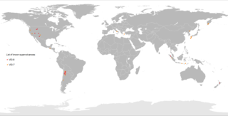
A supervolcano is a volcano that has had an eruption with a Volcanic Explosivity Index (VEI) of 8, the largest recorded value on the index. This means the volume of deposits for such an eruption is greater than 1,000 cubic kilometers.
The volcanic explosivity index (VEI) is a relative measure of the explosiveness of volcanic eruptions. It was devised by Christopher G. Newhall of the United States Geological Survey and Stephen Self at the University of Hawaii in 1982.
The year 1816 is known as the Year Without a Summer because of severe climate abnormalities that caused average global temperatures to decrease by 0.4–0.7 °C (0.7–1 °F). Summer temperatures in Europe were the coldest on record between the years of 1766–2000. This resulted in major food shortages across the Northern Hemisphere.
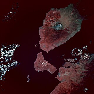
Mount Tambora, or Tomboro, is an active stratovolcano in West Nusa Tenggara, Indonesia. Located on Sumbawa in the Lesser Sunda Islands, it was formed by the active subduction zones beneath it. Before 1815, its elevation reached more than 4,300 metres high, making it one of the tallest peaks in the Indonesian archipelago.
The volcanic winter of 536 was the most severe and protracted episode of climatic cooling in the Northern Hemisphere in the last 2,000 years. The volcanic winter was caused by an eruption, with several possible locations proposed in various continents. Most contemporary accounts of the volcanic winter are from authors in Constantinople, the capital of the Eastern Roman Empire, although the impact of the cooler temperatures extended beyond Europe. Modern scholarship has determined that in early AD 536, an eruption ejected massive amounts of sulfate aerosols into the atmosphere, which reduced the solar radiation reaching the Earth's surface and cooled the atmosphere for several years. In March 536, Constantinople began experiencing darkened skies and cooler temperatures.
A volcanic winter is a reduction in global temperatures caused by volcanic ash and droplets of sulfuric acid and water obscuring the Sun and raising Earth's albedo after a large, particularly explosive volcanic eruption. Long-term cooling effects are primarily dependent upon injection of sulfur gases into the stratosphere where they undergo a series of reactions to create sulfuric acid which can nucleate and form aerosols. Volcanic stratospheric aerosols cool the surface by reflecting solar radiation and warm the stratosphere by absorbing terrestrial radiation. The variations in atmospheric warming and cooling result in changes in tropospheric and stratospheric circulation.
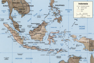
The Sunda Arc is a volcanic arc that produced the volcanoes that form the topographic spine of the islands of Sumatra, Nusa Tenggara, and Java, the Sunda Strait and the Lesser Sunda Islands. The Sunda Arc begins at Sumatra and ends at Flores, and is adjacent to the Banda Arc. The Sunda Arc is formed via the subduction of the Indo-Australian Plate beneath the Sunda and Burma plates at a velocity of 63–70 mm/year.
Lake Ilopango is a crater lake which fills an 8 by 11 km volcanic caldera in central El Salvador, on the borders of the San Salvador, La Paz, and Cuscatlán departments. The caldera, which contains the second largest lake in the country and is immediately east of the capital city, San Salvador, has a scalloped 100 m (330 ft) to 500 m (1,600 ft) high rim. Any surplus drains via the Jiboa River to the Pacific Ocean. An eruption of the Ilopango volcano is considered a possible source for the extreme weather events of 535–536. The local military airbase, Ilopango International Airport, has annual airshows where international pilots from all over the world fly over San Salvador City and Ilopango lake.
This timeline of volcanism on Earth includes a list of major volcanic eruptions of approximately at least magnitude 6 on the Volcanic explosivity index (VEI) or equivalent sulfur dioxide emission during the Quaternary period. Other volcanic eruptions are also listed.
Mount Tambora is a volcano on the island of Sumbawa in present-day Indonesia, then part of the Dutch East Indies, and its 1815 eruption was the most powerful volcanic eruption in recorded human history. This volcanic explosivity index (VEI) 7 eruption ejected 160–213 cubic kilometres (38–51 cu mi) of material into the atmosphere, and was the most recent confirmed VEI-7 eruption.
The 1808 mystery eruption is a large volcanic eruption (VEI-6) conjectured to have taken place in late 1808, possibly in the southwest Pacific. This eruption is suspected of having contributed to a period of global cooling that lasted several years, analogous to how the 1815 eruption of Mount Tambora (VEI-7) led to the Year Without a Summer in 1816. A VEI-6 eruption is comparable to the 1883 eruption of Krakatoa.
Michael R. Rampino is a Geologist and Professor of Biology and Environmental Studies at New York University, known for his scientific contributions on causes of mass extinctions of life. Along with colleagues, he's developed theories about periodic mass extinctions being strongly related to the earth's position in relation to the galaxy. "The solar system and its planets experience cataclysms every time they pass "up" or "down" through the plane of the disk-shaped galaxy." These ~30 million year cyclical breaks are an important factor in evolutionary theory, along with other longer 60-million- and 140-million-year cycles potentially caused by mantle plumes within the planet, opining "The Earth seems to have a pulse," He is also a research consultant at NASA's Goddard Institute for Space Studies (GISS) in New York City.
There are two mystery volcanic eruptions that took place in the mid-1400s: the 1452/1453 mystery eruption and 1458 mystery eruption. By 2013, the time frame had to be re-evaluated because previous ice core work had poor time resolution so there are references to a 1465 mystery eruption based on work a decade earlier. The poor time frame led some to assume a date in the 1460s and was connected to the unusual atmospheric events during the 1465 wedding of Alfonso II of Naples. The exact location of either eruption is uncertain, but both have been assigned at times to the submerged caldera of Kuwae in the Coral Sea. There is evidence otherwise for both eruptions with northern hemisphere emphasis being against the 1452/3 date and composition studies being against the more recent date. The eruption is believed to have been VEI-7 and possibly even larger than Mount Tambora's 1815 eruption.
Little Ice Age volcanism refers to the massive volcanic activities during the Little Ice Age. Scientists suggested a hypothesis that volcanism was the major driving force of the global cooling among the other natural factors, i.e. the sunspot activities by orbital forcing and greenhouse gas. The Past Global Change (PAGES), a registered paleo-science association for scientific research and networking on past global changes in the University of Bern, Switzerland, suggested that from 1630 to 1850, a total of 16 major eruptions and cooling events had taken place. When a volcano erupts, ashes burst out of the vent together with magma and forms a cloud in the atmosphere. The ashes act as an isolating layer that block out a proportion of solar radiation, causing global cooling. The global cooling effect impacts ocean currents, atmospheric circulation and cause social impacts such as drought and famine. Wars and rebellions were therefore triggered worldwide in the Little Ice Age. It was suggested that the crisis on Ottoman Empire and Ming-Qing Transition in China were typical examples that closely correlated with Little Ice Age.
The Tierra Blanca Joven eruption of Lake Ilopango was the largest volcanic eruption in El Salvador during historic times with a Volcanic Explosivity Index of 6, dating back in the mid 5th century A.D. The eruption ejected about 43.7 cubic kilometres (10.5 cu mi) of dense rock equivalent. The eruption was one of the largest volcanic events on Earth in recorded history, i.e. within the last 7,000 years. The possible dates of the eruption are 431 AD or 535–536 AD thus explaining the extreme weather events of 535–536.