List of peaks named Mount Wilson

Last updated

Several peaks are named Mount Wilson or similar:

Contents

Antarctica

Australia

Canada

United States

NameUSGS linkStateCountyUSGS mapCoordinates
Mount Wilson Alaska Prince of Wales-Outer Ketchikan (CA)Bradfield Canal A-2 56°05′48″N130°21′48″W / 56.09667°N 130.36333°W / 56.09667; -130.36333
Wilson Mountain Alabama Calhoun Colvin Gap 33°54′14″N085°50′15″W / 33.90389°N 85.83750°W / 33.90389; -85.83750
Wilson Mountain Alabama Morgan Somerville 34°25′07″N086°49′05″W / 34.41861°N 86.81806°W / 34.41861; -86.81806
Mount Wilson Arizona Mohave Mount Wilson 35°59′48″N114°36′40″W / 35.99667°N 114.61111°W / 35.99667; -114.61111
Wilson Mountain Arizona Coconino Wilson Mountain 34°55′04″N111°45′04″W / 34.91778°N 111.75111°W / 34.91778; -111.75111
Wilson Mountain Arizona Coconino Munds Park 34°54′45″N111°44′56″W / 34.91250°N 111.74889°W / 34.91250; -111.74889
Wilson Mountain Arkansas Pike Lodi 34°19′27″N093°37′58″W / 34.32417°N 93.63278°W / 34.32417; -93.63278
Wilson Knob Arkansas Pulaski Olmstead 34°57′41″N092°09′33″W / 34.96139°N 92.15917°W / 34.96139; -92.15917
Mount Wilson California Los Angeles Mount Wilson 34°13′26″N118°03′37″W / 34.22389°N 118.06028°W / 34.22389; -118.06028
Willson Peak California Santa Clara Gilroy Hot Springs 37°05′43″N121°26′06″W / 37.09528°N 121.43500°W / 37.09528; -121.43500
Wilson Butte California Mono June Lake 37°46′57″N119°01′34″W / 37.78250°N 119.02611°W / 37.78250; -119.02611
Mount Wilson Colorado Dolores Mount Wilson 37°50′21″N107°59′27″W / 37.83917°N 107.99083°W / 37.83917; -107.99083
Wilson Mesa Colorado Rio Blanco Sleepy Cat Peak 40°12′21″N107°31′14″W / 40.20583°N 107.52056°W / 40.20583; -107.52056
Wilson Peak Colorado San Miguel Mount Wilson 37°51′37″N107°59′05″W / 37.86028°N 107.98472°W / 37.86028; -107.98472
Wilson Knob Georgia Rabun Rabun Bald 34°56′36″N083°19′05″W / 34.94333°N 83.31806°W / 34.94333; -83.31806
Wilson Mountain Georgia Union Coosa Bald 34°48′09″N083°55′33″W / 34.80250°N 83.92583°W / 34.80250; -83.92583
Wilson Mountain Georgia Fannin Noontootla 34°42′29″N084°14′46″W / 34.70806°N 84.24611°W / 34.70806; -84.24611
Willson Peak Idaho Valley Profile Gap 45°03′12″N115°26′48″W / 45.05333°N 115.44667°W / 45.05333; -115.44667
Wilson Peak Idaho Gem Tripod Peak 44°27′27″N116°09′33″W / 44.45750°N 116.15917°W / 44.45750; -116.15917
Wilson Peak Idaho Boise Sunset Mountain 43°58′01″N115°45′02″W / 43.96694°N 115.75056°W / 43.96694; -115.75056
Wilson Mountain Idaho Lemhi Hoodoo Meadows 45°05′17″N114°37′30″W / 45.08806°N 114.62500°W / 45.08806; -114.62500
Wilson Butte Idaho Jerome Star Lake 42°47′06″N114°12′51″W / 42.78500°N 114.21417°W / 42.78500; -114.21417
Wilson Mountain Idaho Benewah Santa 47°09′08″N116°24′31″W / 47.15222°N 116.40861°W / 47.15222; -116.40861
Wilson Peak Idaho Owyhee Wilson Peak 43°18′16″N116°44′40″W / 43.30444°N 116.74444°W / 43.30444; -116.74444
Wilson Mountain Kentucky Estill Leighton 37°36′58″N083°58′14″W / 37.61611°N 83.97056°W / 37.61611; -83.97056
Wilson Mountain Massachusetts Norfolk Newton 42°15′25″N071°12′05″W / 42.25694°N 71.20139°W / 42.25694; -71.20139
Wilson Peak Montana Gallatin Gallatin Peak 45°19′37″N111°19′32″W / 45.32694°N 111.32556°W / 45.32694; -111.32556
Wilson Butte Montana Cascade Antelope Butte 47°23′58″N111°22′55″W / 47.39944°N 111.38194°W / 47.39944; -111.38194
Mount Wilson Nevada Clark Blue Diamond 36°05′37″N115°29′01″W / 36.09361°N 115.48361°W / 36.09361; -115.48361
Mount Wilson Nevada Lincoln Schoolmarm Basin 38°15′00″N114°23′36″W / 38.25000°N 114.39333°W / 38.25000; -114.39333
Mount Wilson Nevada Lyon Wilson Canyon 38°51′02″N119°13′08″W / 38.85056°N 119.21889°W / 38.85056; -119.21889
Mount Wilson Nevada Nye Northumberland Pass 38°55′52″N116°50′31″W / 38.93111°N 116.84194°W / 38.93111; -116.84194
Wilson Mesa New Mexico Colfax Johnson Park 36°51′05″N104°10′38″W / 36.85139°N 104.17722°W / 36.85139; -104.17722
Wilson Mesa New Mexico Colfax Abreu Canyon 36°38′14″N105°06′59″W / 36.63722°N 105.11639°W / 36.63722; -105.11639
Wilson Mountain New Mexico Grant Brushy Mountain 32°47′50″N108°41′30″W / 32.79722°N 108.69167°W / 32.79722; -108.69167
Wilson Mountain New Mexico Grant Wilson Mountain 33°09′17″N108°54′49″W / 33.15472°N 108.91361°W / 33.15472; -108.91361
Wilson Mountain New York St. Lawrence Brother Ponds 44°18′23″N074°51′14″W / 44.30639°N 74.85389°W / 44.30639; -74.85389
Wilson Knob North Carolina Mitchell Micaville 35°59′14″N082°07′31″W / 35.98722°N 82.12528°W / 35.98722; -82.12528
Wilson Mountain North Carolina Ashe Baldwin Gap 36°23′53″N081°43′46″W / 36.39806°N 81.72944°W / 36.39806; -81.72944
Mount Wilson Oregon Wasco Mount Wilson 45°04′01″N121°39′25″W / 45.06694°N 121.65694°W / 45.06694; -121.65694
Wilson Mountain Tennessee Overton Hilham 36°26′03″N085°24′34″W / 36.43417°N 85.40944°W / 36.43417; -85.40944
Wilson Mountain Tennessee Johnson Zionville 36°22′16″N081°43′44″W / 36.37111°N 81.72889°W / 36.37111; -81.72889
Wilson Knob Tennessee Greene Flag Pond 36°04′42″N082°34′37″W / 36.07833°N 82.57694°W / 36.07833; -82.57694
Wilson Knob Tennessee McMinn Englewood 35°24′20″N084°26′42″W / 35.40556°N 84.44500°W / 35.40556; -84.44500
Wilson Mountain Texas Coke Dead Indian Mountain 32°02′59″N100°45′03″W / 32.04972°N 100.75083°W / 32.04972; -100.75083
Wilson Mesa Utah San Juan The Rincon 37°16′08″N110°46′04″W / 37.26889°N 110.76778°W / 37.26889; -110.76778
Wilson Mesa Utah Grand Warner Lake 38°32′33″N109°22′11″W / 38.54250°N 109.36972°W / 38.54250; -109.36972
Wilson Peak Utah Garfield Wilson Peak 37°41′21″N112°18′15″W / 37.68917°N 112.30417°W / 37.68917; -112.30417
Mount Wilson Vermont Addison Lincoln 44°00′17″N072°55′35″W / 44.00472°N 72.92639°W / 44.00472; -72.92639
Wilson Mountain Virginia Alleghany Clifton Forge 37°48′45″N079°47′31″W / 37.81250°N 79.79194°W / 37.81250; -79.79194
Wilson Mountain Virginia Rockbridge Arnold Valley 37°34′35″N079°34′07″W / 37.57639°N 79.56861°W / 37.57639; -79.56861
Wilson Mountain Virginia Bath Burnsville 38°08′25″N079°44′09″W / 38.14028°N 79.73583°W / 38.14028; -79.73583
Wilson Knob Virginia Carroll Lambsburg 36°36′48″N080°52′26″W / 36.61333°N 80.87389°W / 36.61333; -80.87389
Wilson Butte Washington Douglas Alameda Flat 48°01′08″N119°08′19″W / 48.01889°N 119.13861°W / 48.01889; -119.13861
Mount Wilson Washington Asotin Jim Creek Butte 45°59′53″N116°58′39″W / 45.99806°N 116.97750°W / 45.99806; -116.97750
Wilson Mountain Washington Stevens Goddards Peak 48°22′08″N117°35′22″W / 48.36889°N 117.58944°W / 48.36889; -117.58944
Wilson Knob West Virginia Upshur Roanoke 38°52′53″N080°22′54″W / 38.88139°N 80.38167°W / 38.88139; -80.38167
Mount Woodrow Wilson Wyoming Sublette/FremontGannett Peak 43°10′01″N109°39′06″W / 43.16694°N 109.65167°W / 43.16694; -109.65167


Related Research Articles

Mount Kailash peak in the Kailash Range

Mount Kailash, is a 6,638 m (21,778 ft) high peak in the Kailash Range, which forms part of the Transhimalaya in the Tibet Autonomous Region of China.

San Gabriel Mountains mountain range in Los Angeles and San Bernardino Counties, California

The San Gabriel Mountains are a mountain range located in northern Los Angeles County and western San Bernardino County, California, United States. The mountain range is part of the Transverse Ranges and lies between the Los Angeles Basin and the Mojave Desert, with Interstate 5 to the west and Interstate 15 to the east. This range lies in, and is surrounded by, the Angeles National Forest, with the San Andreas Fault as the northern border of the range.

The Presidential Range of the Green Mountains is a mountain range in the U.S. state of Vermont. Its major peaks are named for several U.S. presidents of the period from the Civil War through World War I.

Fourteener Wikimedia list article

In the mountaineering parlance of the Western United States, a fourteener is a mountain peak with an elevation of at least 14,000 feet. There are 96 fourteeners in the United States, all west of the Mississippi River. Colorado has the most (53) of any single state; Alaska is in second place with 29. Many peak baggers try to climb all fourteeners in the contiguous United States, one particular state, or another region.

Heritage Range mountain range

The Heritage Range is a major mountain range, 160 km (99 mi) long and 48 km (30 mi) wide, situated southward of Minnesota Glacier and forming the southern half of the Ellsworth Mountains in Antarctica. The range is complex, consisting of scattered ridges and peaks of moderate height, escarpments, hills and nunataks, with the various units of relief set off by numerous intervening glaciers.

Mount Griggs mountain

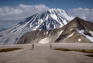
Mount Griggs, formerly known as Knife Peak Volcano, is a stratovolcano, which lies 10 km behind the volcanic arc defined by other Katmai group volcanoes. Although no historic eruptions have been reported from Mount Griggs, vigorously active fumaroles persist in a summit crater and along the upper southwest flank. The fumaroles on the southwest flank are the hottest, and some of the flank fumaroles can roar so loudly that they can be heard from the valley floor. The slopes of Mount Griggs are heavily mantled by fallout from the 1912 eruption of Novarupta volcano. The summit consists of three concentric craters, the lowest and largest of which contains a recent summit cone topped by two craters. The volume of the volcanic edifice is estimated at about 25 cubic kilometres (6.0 cu mi). Isotopic analysis indicates that the source of Griggs' magma is distinct from the other Katmai volcanoes.

Mount Wilson (California) mountain in California, USA

Mount Wilson is a peak in the San Gabriel Mountains, located within the San Gabriel Mountains National Monument and Angeles National Forest in Los Angeles County, California. With only minor topographical prominence the peak is not naturally noticeable from a distance, although it is easily identifiable due to the large number of antennas near its summit. It is a subsidiary peak of nearby San Gabriel Peak.

Mount Wilson can refer to several things:

Lizard Head Wilderness

The Lizard Head Wilderness is a wilderness area in southwest Colorado. It contains 41,309 acres (167.17 km2) and is jointly managed by the Uncompahgre and San Juan National Forests. It is 10 miles (16 km) southwest of the town of Telluride and is named for a prominent rock formation that is said to look like a lizard's head. Lizard Head itself is 13,113 feet (3,997 m) and is a volcanic spire of crumbling rock. Due to the steepness of the cliffs and the poor quality of the rock for fixing ropes, only experienced mountaineers should attempt to summit the spire. Another 37 miles (60 km) of trails in this infrequently visited wilderness, are also strenuous and should be attempted by more advanced backpackers.

Wilson Peak mountain in Colorado, USA

Wilson Peak is a 14,023-foot (4,274 m) mountain peak in the U.S. state of Colorado. It is located in the Lizard Head Wilderness of the Uncompahgre National Forest, in the southern San Juan Mountains. It is the highest point in San Miguel County.

El Diente Peak mountain in United States of America

El Diente Peak is a high summit in the San Miguel Mountains range of the Rocky Mountains of North America. The 14,165-foot (4,317 m) peak is located in the Lizard Head Wilderness of San Juan National Forest, 10.5 miles (16.9 km) north by east of the Town of Rico in Dolores County, Colorado, United States. "El Diente" is Spanish for "The Tooth", a reference to the shape of the peak.

Mount Wilson (Colorado) mountain in United States of America

Mount Wilson is the highest summit of the San Miguel Mountains range of the Rocky Mountains of North America. The prominent 14,252-foot (4,344 m) fourteener is located in the Lizard Head Wilderness of San Juan National Forest, 10.6 miles (17.1 km) north by east of the Town of Rico in Dolores County, Colorado, United States. Mount Wilson should not to be confused with the lower Wilson Peak nearby.

Mount Woodrow Wilson mountain in United States of America

Mount Woodrow Wilson is located in the Wind River Range in the U.S. state of Wyoming. Mount Woodrow Wilson is the eighth-highest mountain in the range and the ninth-highest in Wyoming. The summit is located in the Bridger Wilderness of Bridger-Teton National Forest on the Continental Divide, 1.25 miles (2.01 km) south of Gannett Peak. The flanks of the mountain are covered in snowfields and glaciers, including Dinwoody Glacier to the northeast, Mammoth Glacier to the west and Sphinx Glacier to the south.

Twin Peaks (Wyoming) mountain in Wyoming, United States of America

Twin Peaks is located in the Wind River Range in the U.S. state of Wyoming. Twin Peaks is the 20th highest peak in Wyoming. Twin Peaks is in the Bridger Wilderness of Bridger-Teton National Forest and is .58 mi (0.93 km) southwest of Mount Woodrow Wilson and about the same distance southeast of Split Mountain. Mammoth Glacier flows from the north slopes of the peak while the smaller Twins Glacier flows to the southeast.