
Boone County is a county located in the U.S. state of Kentucky. As of the 2010 census, the population was 118,811, making it the fourth-most populous county in Kentucky. Its county seat is Burlington. The county was formed in 1798 from part of Campbell County. and was named for frontiersman Daniel Boone.

Linn Boyd was a prominent US politician of the 1840s and 1850s, and served as Speaker of the United States House of Representatives from 1851 to 1855. Boyd was elected to the House as a Democrat from Kentucky from 1835 to 1837 and again from 1839 to 1855, serving seven terms in the House. Boyd County, Kentucky is named in his honor.

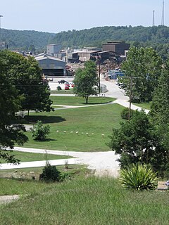
Cannonsburg is a census-designated place (CDP) in Boyd County, Kentucky, United States. As of the 2010 census, it had a population of 856. Cannonsburg is located 8 miles (13 km) southwest of the city of Ashland, a major urban center in northeastern Kentucky. Most of Cannonsburg shares its ZIP code with Ashland; however, parts are within the Catlettsburg ZIP code. The Cannonsburg post office closed in 1929. Cannonsburg is a part of the Huntington-Ashland Metropolitan Statistical Area (MSA). As of the 2010 census, the MSA had a population of 287,702. New definitions from February 28, 2013 placed the population at 363,000.
Kentucky Route 3 is a 79.158-mile-long (127.392 km) state highway in the U.S. state of Kentucky.
Summit is an unincorporated community in Boyd County, Kentucky, United States on US 60 just west of Ashland. Summit serves as a suburb to the city of Ashland and shares the city's ZIP code. Summit is sometimes spelled with two "T's" at the end, although the most common spelling contains only one "T" but either variation is accepted as correct.
Meads is an unincorporated community in Boyd County, Kentucky, United States. It is located along the U.S. Highway 60 corridor south of Ashland.
Princess is a small unincorporated community in Boyd County, Kentucky, United States. Princess is located along Kentucky Route 5, near the intersection of U.S. Route 60 and Kentucky Route 5.
Coalton is an unincorporated community situated along U.S. Route 60, which was formerly known as the Midland Trail in western Boyd County, Kentucky, United States. U.S. Route 60 n Kentucky|U.S. Route 60]] between Rush and Cannonsburg. Coalton is a part of the Huntington-Ashland Metropolitan Statistical Area (MSA). As of the 2010 census, the MSA had a population of 287,702. New definitions from February 28, 2013 placed the population at 361,500. Coalton is located within both the Ashland and Rush postal zip codes.
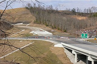
Kentucky Route 67 is a Kentucky State Highway originating at a junction with Interstate 64 near Grayson, Kentucky in Carter County. The route continues through rural ridgetops in Greenup County and briefly touches Boyd County before terminating at U.S. Highway 23 in Greenup County in between Wurtland and Greenup. KY 67 is also known as the Industrial Parkway.
Ironville is an unincorporated community in Boyd County, Kentucky, United States, near the intersection of Kentucky Route 5 and Kentucky Route 766. Due to its proximity to Ashland, Ironville is often considered to be a part of Ashland, although officially it is separate from the city and serves as a suburb to the city. It shares its ZIP code with Ashland as well.
Rockdale is an unincorporated community in Boyd County, Kentucky, United States, located south of Ashland. It is located on Midland Trail at its intersection of Kentucky Route 538 and corridor into the city of Ashland. It was mostly a rural area until the 1970s, when a large subdivision began development, with several hundred tract houses.
Kentucky Route 716 is a 1.565-mile-long (2.519 km), north–south highway running through Summit, in Boyd County.
Kavanaugh, Kentucky is an unincorporated community located in Boyd County, Kentucky, located along U.S. Route 23 directly north of the Lawrence County line. In 1984, the original alignment of U.S. 23 was replaced with a modern four-lane highway. CSX Transportation's Big Sandy Subdivision railroad tracks pass through the community. The railroad was formerly operated by the Chessie System and its predecessor the Chesapeake and Ohio Railway Company.
Garner is an unincorporated community in Knott County, Kentucky, United States. Garner is located at the junction of Kentucky Route 550 and Kentucky Route 1697 3.4 miles (5.5 km) east-northeast of Hindman. Garner had a post office, which closed on November 12, 2011; it still has its own ZIP code, 41817.
Garner is an unincorporated community in Boyd County, Kentucky, United States. Garner is located on Pigeon Roost Creek at the junction of Kentucky Route 854 and Kentucky Route 1945, 10.6 miles (17.1 km) southwest of Catlettsburg.
Little Rock is an unincorporated community in Bourbon County, Kentucky, United States. Little Rock is located on Kentucky Route 537 11 miles (18 km) east of Paris.


