
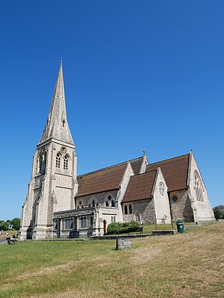
Becontree or is an area of approximately 4 square miles (10 km2) in the London Borough of Barking and Dagenham. It is located 11 miles (17.7 km) east-northeast of Charing Cross and was constructed in the interwar period as the largest public housing estate in the world. The Housing Act 1919 permitted the London County Council to build housing outside the County of London and Becontree was constructed between 1921 and 1935 to cottage estate principles in the parishes of Barking, Dagenham and Ilford, then in the administrative and ceremonial county of Essex. The official completion of the estate was celebrated in 1935, by which time the estate had a population of around 100,000 people in 26,000 homes.

Bethnal Green is an area in the East End of London 3 miles (4.8 km) northeast of Charing Cross. The area emerged from the small settlement which developed around the Green, much of which survives today as Bethnal Green Gardens, beside Cambridge Heath Road. By the 16th century the term applied to a wider rural area, the Hamlet of Bethnal Green, which subsequently became a Parish, then a Metropolitan Borough before merging with neighbouring areas to become the north-western part of the new London Borough of Tower Hamlets.
Blackheath is an area in Southeast London, straddling the border of the Royal Borough of Greenwich and the London Borough of Lewisham. It is located 1-mile (1.6 km) northeast of Lewisham, 1.5 miles (2.4 km) south of Greenwich and 6.4 miles (10.3 km) southeast of Charing Cross, the traditional centre of London.

The London Borough of Hounslow is a London borough in West London, England, forming part of Outer London. It was created in 1965 when three smaller borough councils amalgamated under the London Government Act 1963. It is governed by Hounslow London Borough Council.
Dagenham is a town in East London, England, within the London Borough of Barking and Dagenham. Dagenham is centred 11.5 miles (18.5 km) east of Charing Cross.

Little London is a village situated between the North Hampshire Downs and the gravel plains of the Kennet valley, 7 miles (11 km) north of Basingstoke and 15 miles (24 km) south of Reading. It is situated within Pamber civil parish and backs on to Pamber Forest, a 500-acre (2.0 km2) SSSI and remnant of the much larger ancient Royal Forest of Pamber. It is recorded as having been established for at least 400 years.

Reigate is a town in Surrey, England, around 19 mi (31 km) south of central London. The settlement is recorded in Domesday Book in 1086 as Cherchefelle and first appears with its modern name in the 1190s. The earliest archaeological evidence for human activity is from the Paleolithic and Neolithic, and during the Roman period, tile making took place to the north east of the modern centre.

Elmbridge is a local government district with borough status in Surrey, England. Its principal towns and villages are Esher, Cobham, Walton-on-Thames, Weybridge and Molesey. It directly borders the London Borough of Richmond upon Thames and the London Royal Borough of Kingston upon Thames. Some areas of the borough form a continuation of the Greater London Built-up Area, formerly falling into the Metropolitan Police District.

Chadwell Heath is a town in East London, England. It is split between the London Borough of Barking and Dagenham and the London Borough of Redbridge, around 2 miles (3.2 km) west of Romford and 4 miles (6.4 km) east of Ilford, and 12 miles (19 km) north-east of Charing Cross.

Lesnes Abbey is a former abbey, now ruined, in Abbey Wood, in the London Borough of Bexley, southeast London, England. It is a scheduled monument, and the abbey's ruins are listed at Grade II by Historic England.

Cambridge Heath is an urban area of Bethnal Green in the London Borough of Tower Hamlets, approximately 5.7 km (3.5 mi) north east of Charing Cross. It is named after a former heath in the East End of London. The northern boundary is formed by the Regent's Canal and the area includes Vyner Street, best known for its street art and galleries.

Barking was a local government district, and later civil parish and borough, in southwest Essex, England from 1882 to 1965. It was known as Barking Town from 1882 to 1931. The district included the town of Barking, eastern Beckton and the southwestern part of the Becontree estate. The district was within the Metropolitan Police District and experienced a steady increase in population during its existence. It now forms the western part of the London Borough of Barking and Dagenham and the eastern extremity of the London Borough of Newham in Greater London.
The London Borough of Barnet, located on the northern periphery of London and having much of the area within its boundaries in the Metropolitan Green Belt, has many parks and open spaces. In addition there are large areas taken over by cemeteries and golf courses, and part of Hampstead Heath.
Marks Gate is an area in Little Heath in Ilford at the northern tip of the London Borough of Barking and Dagenham in East London, England. It is located immediately north of Chadwell Heath and to the west of Romford.
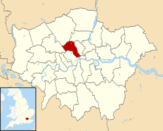
Becontree was an ancient hundred in the south west of the county of Essex, England. Its area has been entirely absorbed by the growth of London; with its name reused in 1921 for the large Becontree estate of the London County Council. Its former area now corresponds to the London Borough of Newham, the London Borough of Barking and Dagenham and parts of the London Borough of Waltham Forest and the London Borough of Redbridge. Its early extent also included parts of what is now the London Borough of Havering.
There are various formal and informal subdivisions of London Borough of Barking and Dagenham and of parts of that borough.
The London Borough of Camden was created in 1965 from the former area of the metropolitan boroughs of Hampstead, Holborn, and St Pancras, which had formed part of the County of London. The borough was named after Camden Town, which had gained its name from Charles Pratt, 1st Earl Camden in 1795. Since the 17th century, many famous people have lived in its various districts and neighbourhoods.
The London Borough of Camden is a London borough in Inner London. Camden Town Hall, on Euston Road, lies 1.4 mi (2.3 km) north of Charing Cross. The borough was established on 1 April 1965 from the area of the former boroughs of Hampstead, Holborn, and St Pancras—which together, prior to that date, had comprised part of the historic County of London.

Little and Lesnes was a hundred, a historical land division, in the county of Kent, England. It occupied the northern part of the Lathe of Sutton-at-Hone, within in the west division of Kent. Little and Lesnes was the northernmost hundred in the whole county of Kent. The hundred existed since ancient times, before the Domesday Book of 1086, until it was made obsolete with the creation of new districts at the end of the nineteenth century.


