
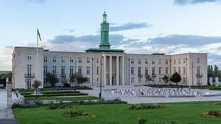
Chingford is a suburban town in east London, England, within the London Borough of Waltham Forest. The centre of Chingford is 9.2 miles (14.8 km) north-east of Charing Cross, with Waltham Abbey to the north, Woodford Green and Buckhurst Hill to the east, Walthamstow to the south, and Edmonton and Enfield to the west. It had a population of 70,583 at the 2021 census.
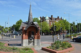
Walthamstow is a town within the London Borough of Waltham Forest in east London. The town borders Chingford to the north, Snaresbrook and South Woodford to the east, Leyton and Leytonstone to the south, and Tottenham to the west. At the 2011 census, Walthamstow had a population of approximately 109,424 and is around 7.5 miles (12 km) north-east of Central London.
Wanstead is an area in East London, England, in the London Borough of Redbridge. It borders South Woodford to the north, Redbridge to the east and Forest Gate to the south, with Leytonstone and Walthamstow to the west. It is located 8 miles northeast of Charing Cross.

The London Borough of Waltham Forest is an outer London borough formed in 1965 from the merger of the municipal boroughs of Leyton, Walthamstow and Chingford.

The London Borough of Redbridge is a London borough established in 1965.

Leytonstone is an area in East London, England, within the London Borough of Waltham Forest. It adjoins Wanstead to the north-east, Forest Gate to the south-east, Stratford to the south-west, Leyton to the west, and Walthamstow to the north-west, and is 7 miles (11 km) north-east of Charing Cross.
Hainault is a large suburban area of Ilford in East London, England, in the London Borough of Redbridge, 12.5 miles (20.1 km) northeast of Charing Cross. Most of the housing in Hainault was built by the London County Council between 1947 and 1953. Originally spanning the parishes of Chigwell, Dagenham, and Ilford, in 1965 the estate was combined in a single London borough and became part of Greater London.

Woodford Green is an area of Woodford in East London, England, within the London Borough of Redbridge. It adjoins Buckhurst Hill to the north, Woodford Bridge to the east, South Woodford to the south, and Chingford to the west. Epping Forest runs through Woodford Green in the west of the area, 9.4 miles (15.1 km) north-east of Charing Cross.

Leytonstone is a London Underground station in Leytonstone in the London Borough of Waltham Forest, east London. It is on the Central line, on the boundary of Zones 3 and 4. Towards Central London, the next station is Leyton, while going east from Leytonstone, the line divides into two branches. On the direct route to Woodford and Epping the next stop is Snaresbrook, and on the Hainault loop it is Wanstead. The station is close to Whipps Cross University Hospital. It is a terminus for some services and returns westbound.

Buckhurst Hill is an affluent suburban town in Epping Forest, Essex, within the Greater London Urban Area and adjacent to the northern boundary of the London Borough of Redbridge. The area developed following the opening of a railway line in 1856, originally part of the Eastern Counties Railway and now on the Central line of the London Underground.

South Woodford is an area of East London, England, within the London Borough of Redbridge. It adjoins Woodford Green to the north, Walthamstow to the west, Snaresbrook and Wanstead to the south and Redbridge to the east, and is 8.9 miles (14.3 km) north-east of Charing Cross. Epping Forest runs adjacent to South Woodford in the west of the area.

Leyton and Wanstead is a constituency in Greater London created in 1997 and represented in the House of Commons of the UK Parliament since 2024 by Calvin Bailey of the Labour Party.

Chingford and Woodford Green is a constituency in North East London represented in the House of Commons of the UK Parliament by Sir Iain Duncan Smith of the Conservative Party since its creation in 1997.

Walthamstow is a constituency in Greater London created in 1974 and represented in the House of Commons of the UK Parliament since 2010 by Stella Creasy, a member of Labour Co-op.

The region of Greater London, including the City of London, is divided into 75 parliamentary constituencies which are sub-classified as borough constituencies, affecting the type of electoral officer and level of expenses permitted. Since the general election of July 2024, 59 are represented by Labour MPs, 9 by Conservative MPs, 6 by Liberal Democrat MPs, and 1 by an independent MP.
Cann Hall is a former civil parish in the south of Leytonstone in the London Borough of Waltham Forest. It is north of Stratford and Forest Gate, east of Leyton, and west of Wanstead Flats, the southernmost tip of Epping Forest.

Wanstead Flats is the southernmost portion of Epping Forest, in Leytonstone and Wanstead, London. The flats and by extension the forest ends at Forest Gate directly to the south. It now falls wholly within the boundaries of the London Boroughs of Redbridge and Waltham Forest, though until 1994 two parts of it were in the London Borough of Newham: one of these was the section between Aldersbrook Road and Capel Road east of the junction between Aldersbrook Road and St Margaret's Road, whilst the other was the strip running along Capel Road between its junctions with Centre Road and Ridley Road. As part of Epping Forest, the Flats is managed by the City of London Corporation.

Woodford Bridge is part of the East London suburb of Woodford, in the London Borough of Redbridge. It is located on an old road between Chigwell and Leytonstone.
Wanstead and Woodford was a constituency in North East London, represented in the House of Commons of the Parliament of the United Kingdom. It elected one Member of Parliament (MP) by the first past the post system of election. The constituency existed from the 1964 general election until it was abolished in the 1997 general election.

Woodford is a town in East London, England, within the London Borough of Redbridge. It is located 9.5 miles (15.3 km) north-east of Charing Cross. Woodford historically formed an ancient parish in the county of Essex. It contained a string of agrarian villages and was part of Epping Forest. From about 1700 onwards, it became a place of residence for affluent people who had business in London; this wealth, together with its elevated position, has led to it being called the Geographical and social high point of East London. Woodford was suburban to London and after being combined with Wanstead in 1934 it was incorporated as a municipal borough in 1937. It has formed part of Greater London since 1965 and comprises the neighbourhoods of Woodford Green, Woodford Bridge, Woodford Wells and South Woodford. The area is served by two stations on the Central line of the London Underground: Woodford and South Woodford.


